Preparations for the 7-8th July NATO Leaders’ Summit in Ankara.involved the opening of a new military headquarters, airport expansion and a new/upgraded road network.
Ankara Airport including runway extension, Ay Yildiz (Crescent and Star) Joint Command Headquarters and parts of the 12.5km new and upgraded road network
Heads of state of all 32 NATO member countries, along with Ukrainain representatives, are expected to attend the NATO Leaders’ Summit in Ankara, capital city of Türkiye, on 7-8th July 2026. The summit will showcase the new Ay Yıldız (Crescent & Star) Joint Command Headquarters, named after the crescent and star of the national flag. Located 15 kilometres west of Ankara the 1,280 hectare complex, larger than many city centres, will host Turkey’s main military institutions including the Defense Ministry, General Staff and the army, navy and air force commands. The NATO summit will be held in the star-shaped part of the campus, prepared specifically for the event and the focal point of a 23,000 square metre ceremonial plaza. Becoming operational in phases, the wider Ay Yildiz campus will ultimately have capacity for 15,000 personnel, the central crescent-shaped building containing five conference halls. Officials have said that Ay Yildiz is larger than the US Pentagon. A new building to host the Foreign Ministry will be constructed next to the military complex. An underground operations centre focused on chemical, ballistic, radiological, nuclear (CBRN) and cybersecurity threats will be located 30 metres beneath the surface.
A new VIP airport
To the north of Ay Yildiz, Etimesgut Aır Base, a military airfield and a main base for the Turkish Air Force, also serving as a training and logistics centre, has been transformed into what some media outlets describe as a new VIP airport for presidents, prime ministers and other high-ranking officials. US President Donald Trump will be arriving for the NATO Summit in his new Air Force One aircraft gifted by Qatar. In the lead-up to the event, just before an opening ceremony on 15th June, President Recep Tayyip Erdoğan’s aircraft was welcomed at the facility, now named Ankara Airport, with a water salute. In time for the summit, over a period of just eight months the runway was lengthened from 2,450 metres to 3,000 metres and widened from 42 metres to 60 metres to handle wide-bodied aircraft. Taxiways have been constructed and a new 160,000 square meter apron has capacity for 44 aircraft. Relocation of the VIP terminal was fast-tracked for completion in time for the NATO Summit and high-ranking visitors can be accommodated in a new 4,800 square metre state guesthouse (an official venue for state functions and meetings). A new parking area is large enough for 310 vehicles.
A new/upgraded road network
The airport expansion project, estimated by the government to cost 10 billion lira (USD320 million), included construction of Baskent Aviation Bridge (Başkent Havacılık Köprüsü) and 12.5 kilometres of new and upgraded roads connecting Ankara Airport with surrounding areas, including a 3 kilometre dedicated connection road between the airport and the NATO Summit venue. Aırport and road expansion impacted on the Ankara Sugar Factory industrial complex, which was established in the late 1950s. Several residential blocks were demolished and some administrative buildings removed. The airport upgrade and road projects have also led to changes to or removal of public transport routes in some neighbouring districts, in some of which, such as Batikent and Eryaman, where residents might experience an increase in aircraft noise.
Pre-summit crackdown
During the lead up to the summit Turkish authorities launched a crackdown on civil society. Protests were banned, along with public gatherings, press conferences and displaying posters. In Ankara, 40,000 police were deployed and on 23rd June 225 people, including academics and activists, were detained on suspicion of links to militants organisations such as Islamic State. Media freedoms were curbed including refusing accreditation dozens of journalists, to the NATO summit. Together with 14 press freedom organisations the International Press Institute (IPI) sent a letter to NATO chief Mark Rutte, calling on the alliance to reconsider the accreditations. One of the journalists whose accreditation was denied, Işın Eliçin of the independent media outlet Halk TV, said, “An unexplained exclusion of journalists restricts media freedom and ultimately the public’s rights…to receive independent information about NATO’s work.” IPI national committee member Uraz Kaspar said, “Every rejected journalist deserves a clear, specific and transparent reason for their denial.” Then, on 4th July, two days before the summit, more than 100 people, members of the TKP (Communist Party) participating in an anti-NATO demonstration in Kizilay Square in central Ankara, were detained by authorities. Protest spread from Ankara to Istanbul where there was a heavy police presence but no clashes were reported.
Thousands of trees were felled for the Sagarmatha Airport project, but it has not been constructed and the abandoned site has turned into pasture.
Aerial imagery of the Sagarmatha Airport site shows deforestation in perparation for construction
The Sagarmatha Airport project, in Triyuga Municipality, Udayapur District of Koshi Province, Nepal, was first announced in 2013. According to the Environmental Impact Assessment (EIA) for the airport 35,514 trees covering 124 hectares of land would be cut down to make way for a 200 metre runway, terminal, taxiways, staff quarters and other infrastructure. In April 2018, responding to protests by local people against felling trees in the local community forest for the airport, the Triyuga Municipality began to consider building the airport on unused land along the banks of the Triyuga and Luhale rivers. A year later surveys of the proposed site were complete and the Ministry of Industry, Tourism, Forest and Environment (MoITFE) announced that construction of the airport was imminent. Site clearance for Sagarmatha Airport did entail large-scale deforestation; by November 2022 70 per cent of the trees in the 105.11 hectare area allocated for the project, at this juncture named Sagarmatha Domestic Airport, had been cut down by the company awarded the tender for construction of the airport. An agreement between the Department of Forestry and Soil Conservation, signed in February 2022, had allowed use of the forested land for the airport.
In January 2024, the Centre for Investigative Journalism-Nepal reported that the Civil Aviation Authority of Nepal (CAAN) had spent Rs 24.7 million (USD169,000) clearing forest for airport construction and approximately 13,687 trees from the community forest had been cut down and sold. Foundation stones marking the start of construction had been laid in three locations. Following a site visit in February 2024 Minister for Culture, Tourism and Civil Aviation, Sudan Kirati said the government would proceed with the airport and committed more funds, “A total of Rs 50 million has been allocated for the construction of the airport.”
In October 2025, Kathmandu Post reported that, after the forest was cleared, no construction works had taken place. The airport had not materialised and 105 hectares of forest cleared for the project was being used as grazing land for cattle. A Division Forest Office Official admitted that the timber was not fully accounted for or utilised properly and said, “Some wood was distributed to local users through community forest groups, but a large quantity was reportedly sold elsewhere”. Some locals alleged that forest officials and community forest group members had colluded in illegal sales of the highest-quality timber. A Triyuga local commented, “They destroyed the forest for an airport that never got built. What’s left now is a pastureland where people graze their cattle.” Environmentalists criticised the government for permitting forest clearance for an unviable airport project. Kushal Babu Basnet, Udayapur chair of the Federation of Community Forestry Users, said “This is a textbook case of how politically driven projects can cause irreversible environmental loss.” Responsibility for protection of the site, at risk of encroachment, was unclear with the Division Forest Office insisting that land ownership had been transferred to CAAN whereas the Land revenue Office denied any record of this.
Sagarmatha Airport is not the only abandoned airport in Nepal, the country has a history of building airports that languish unused. According to a report by CAAN, of Nepal’s 55 domestic airports only 32 were operational with just seven making a profit. A retired CAAN official includes Sagarmatha Airport in a long list of airports constructed at the behest of powerful politicians. Several airports in particularly remote areas had initially served as a ‘lifeline’ for isolated communities as there were no roads; many of these airports were built 1 – 3 hours driving distance from the national highway network. But when roads connecting these airports to national highways were constructed they were utilised by poor locals for whom the airports were not a priority. Weather is another factor affecting viability of new airports, some of which can only be used as seasonal facilities. Former CAAN director general Sanjiv Gautam explained that airport viability depends on the income of the local area, saying “many airports built in past decades have turned into grazing fields”.
Research by the Centre for Investigative Journalism-Nepal into Nepal’s abandoned airports, published in January 2024, mentions Sagarmatha Airport as one of several uncompleted and unused airports incurring significant public costs, ‘From East to West, there are more than 20 domestic airports in various stages of construction and abandonment’. Airports superseded by roads include Jiri Airport, the ‘gateway to Everest’, now used as pastureland following connection to the road network and the non-operational Tikapur Airport, in the far west of Nepal, through which locals have built a road.
Construction of the Great Transfiguration Project – a mega tourism development n the St. Catherine areacomprising luxury hotels, villas, chalets, visitors centre, shopping bazaars, housing and roads –is linked to expansion of St. Catherine Airport.
Great Transfiguration Project (GTP) area, Egypt. Aerial imagery: 2nd July 2023
The Great Transfiguration Project (GTP), a mega tourism development project including hotels, villas, chalets, private housing, shopping bazaars, other facilities and roads in and around the St. Catherine area – a designated UNESCO World Heritage Site which includes St. Catherine’s Monastery and Mount Sinai – was announced by the Egyptian government in March 2021. Within weeks demolitions and construction works by private companies began. An August 2022 statement by the Egyptian Human Rights Forum (EHRF) detailed the project components, situation on the ground, impacts on and response from local communities and NGOs and comments from experts. Many contributors confirmed that GTP implementation had already caused serious, irreversible damage of nature, ecosystems, heritage and negative impacts on local people. EHRF’s statement said authorities had not included the local Jebeleya Bedouin tribe or the wider local community and that local organisations, community representatives, experts and representatives of St. Catherine’s Monastery (one of the oldest continuously inhabited monasteries in the world) and its inhabitants had not been consulted. A St. Catherine’s expert said homes were being demolished without compensation, part of the mosque had been demolished and the cemetery dug up. An eyewitness said many old olive and pistachio trees had been removed and some locals had worked together to replant them in different gardens. Construction of a 70km highway connecting St. Catherine with Al-Tur, on the Gulf of Suez, raised concerns over the environmental impacts. An expert on St. Catherine’s natural environment said, “This highway destroys an area designated by Egypt’s government as a nature protectorate, it cuts through the protected area and splits it in two, causing environmental ruin.”
In March 2022 a Middle East Eye correspondent gathered testimony from several local people concerned about the impacts of the GTP. One resident spoke of concern for the future of the heritage site, saying, “What is sold to us as development is in fact ruining this ancient and beautiful city.” A tourism worker, one of several people commenting on social media and posting photos of demolished buildings, said, “The view to most of the ancient sites of the city will be blockade by the concrete buildings now constructed in it”. One resident spoke of bulldozers tearing down important buildings, replacing them with blocks of concrete. Another resident said, “We wake up every day to discover that some buildings have been demolished and other made of cement constructed instead of them.” Mada Masr reported that two anonymous sources said the government began implementation of the project before submitting environmental impact assessments. A resident raised concerns over the project’s water consumption in a city reliant on wells and tanker trucks from Al-Tur saying, “Where will you get water for those employed in hotels, chalets and homes? They’re building swimming pools while people still wait for the water trucks once a week.” Accommodation built for relocation of residents, apartments in multi-storey buildings, some of which were already housing displaced residents, were very different from Bedouin’s traditional single-floor dwellings with gardens. One resident said, “These do not look like our homes nor do they align with our customs. We would not know how to live comfortably. But when they relocate us, we will have no other choice.”
Concluding a 10th March 2024 inspection tour in St. Catherine to assess the development projects Prime Minister Mostafa Madbouli said the GTP would be Egypt’s gift to the entire world. He said the state had made significant efforts to implement the project, beginning with development of St. Catherine International Airport, located 20km northeast of the city, into an international airport. A World Heritage Watch press release entitled ‘Mount Sinai: A Sacred Landscape Disfigured by a Megatourism Project’, issued on 18th December 2024 stated, “A new urban world is being built around a people of nomadic heritage,” It stated that the site surrounding St. Catherine’s monastery had been transformed. Landscapes had been damaged, the rights of indigenous people violated, houses demolished, important cultural sites destroyed and Bedouins had lost tribal territories. Heritage groups around the world had raised the alarm about the scale of commercial and infrastructure development in St. Catherine. Fourteen plots of land confiscated from the monastery by the Court of Appeals included agricultural land, gardens and buildings protected as antiquities including Saint Panteleimon Church on Mount Sinai which dates back to the 6th-7th centuries. In 2023, UNESCO had asked the Egyptian government to halt further development projects, evaluate the impacts and prepare a conservation plan for the area. The requests were ignored and construction of concrete buildings including luxury hotels, new roads and development of St. Catherine’s Airport into an international facility with a 3km runway, enlarged terminal and VIP lounge continued. Speaking to New Lines Magazine in June 2025 an anonymous resident said, “the fate of personal property that falls in the way of this construction remains unclear. Assurances and fake promises change day by day.” An anonymous expert said Jebeleya people’s homes were being demolished with no compensation. The aforementioned bulldozed cemetery had been paved over to create a parking lot. Plans for 700 new housing units caused worries that Bedouins might be displaced. An anonymous expert said, “Many fear they could be compensated with an apartment, which does not suit their way of life. They need outdoor space – for their livestock and to plant.”
For more information including references for all source material see the case study on EJAtlas, the world’s largest, most comprehensive online database of social conflict around environmental issues – Great Transfiguration Project, Egypt
Earthworks for construction of an airport on Koh Rong island, 25 km from the city of Sihanoukville on Cambodia’s south-west coast, began in January 2024. Satellite imagery shows the airport site, located in a flat area in the centre of the island. The new airport with a 2.650 metre runway will have capacity to handle 138,000 passengers annually upon completion of the first phase and the MoU signed in January 2023 formalised a budget of $300 million. The necessity and viability of Koh Rong International Eco-Tourism Airport seems questionable with two major international airports nearby. Newly constructed Dara Sakor Airport, with capacity for 10 million passengers per annum and scheduled to begin operations in November 2024, is only 21km away. Sihanouk Airport is 45 km away. Also, Koh Rong is already well served by boat; the ferry journey from Sihanoukville only takes about 45 minutes.
Satellite imagery of Koh Rong dated 1st November 2023, showing location of the four coastal villages, Royal Sands resort, long beach, major roads and Koh Rong International Eco-Tourism Airport construction site.
The new airport will be named ‘Koh Rong International Eco-Tourism Airport’. While an airport enables people to visit and explore protected beaches, forests and native wildlife habitats, it does the very opposite of protecting ecosystems, concreting over a vast area for runways, terminals and access roads. Then there is the issue of climate disrupting greenhouse gas emissions from flights, with aviation being energy intensive and dependent upon fossil fuels. And tourism development on Koh Rong has damaged ecosystems and the people depending on them. In 2008, Royal Group, one of the largest investment and development companies in Cambodia, was granted a 99-year land concession to develop the 78 square kilometre island. Realisation of the masterplan – featuring resorts, casinos, marinas, golf courses, two fishing villages and an airport – was delayed but commenced in 2015 with clearance of sites along the southwestern coast including forests along with construction of a road. On 3rd July 2015 Koh Touch villagers held a sit-in protest, blocking construction crews, excavators and a bulldozer, in response to construction of a road which they said would cut through their village and affect their homes. Later that month opposition to development of Koh Rong became more vocal in response to construction equipment and workers appearing on the island. Hundreds of residents began to speak out on social media. As well as cutting trees cliffs and rocky outcrops had been flattened for development, including a new pier on Long Beach, on the southeast of the island.
In August 2015 a number of Koh Kong residents called on officials to review what they called “abusive activities” by Royal Group. Construction had accelerated in recent weeks and workers and machinery had been photographed clearing large areas of forest. Residents accused Royal Group of destroying farmland and crops, including cashew, jackfruit, coconut and mango trees. A village leader said destruction could impact the livelihoods of over 100 families, who had lived on the island since 1995. Villagers said the destruction of their livelihoods was illegal and authorities should monitor the situation. Human rights and environmental campaigners supported residents’ calls for improved oversight and local groups were preparing petitions and other documents to file with provincial and national authorities. Protest groups had been formed in response to a breakdown in communications between residents and Royal Group. One villager said, “They come in and do their work, take whatever they want, but there is no communication”.
Controversy over land titles for Koh Rong villagers was reported in 2017. Some residents who had lived on the island since before 2008 had land titles, although it was uncertain whether these titles would be upheld amid disputes. Those arriving after 2008 did not have land titles. By 2018 over 1,000 land plots, belonging to 500 families, had been recognised by the government, but in April 2018, during the inauguration of the luxurious, five-star Royal Sands Koh Rong resort, about 50 people who had not yet received land titles attempted to join the event but were prohibited from doing so. Prime Minister Hun Sen ordered the Ministry of Land Management to bring an end to the Koh Rong land dispute. In June 2020 53 families protested land clearance; a 35-hectare site they believed rightfully belonged to them was being bulldozed. A Preah Sihanouk Provincial Administration spokesperson called on the protesting families to cooperate with authorities by providing relevant documents and warned them that if they caused chaos legal action would be taken against them. A member of one of the protesting families claimed they had lived in the area since 1992 and said: ”We won’t go anywhere. I will gather to protest at this site. We dare not enter the bulldozing site. I want Prime Minister Hun Sen to see and tackle this issue for us. We all have ownership documents.”
In June 2024 Mongabay reported that a new map of Royal Group’s plans for Koh Rong showed golf course zones, commercial zones, accommodation zones, casinos zones and an international airport. The latest plans did not appear to impact fishing villages but included clearing some of the Koh Rong’s protected forests to make way for golf courses. In total, project plans entail clearing more than 3,100 hectares of the island’s forests. A photo showed bulldozers and trucks working on the airport site. Sixteen years after the land was leased to Royal Group there was still no publicly available social or environmental impact assessment and islanders’ future was uncertain. Some Koh Rong residents hoped to sell their land to Royal Group while others feared that it would be taken from them.
For more information about the airport and tourism projects on Koh Rong island, including references for all source material, see the case study on EJAtlas, the world’s largest, most comprehensive online database of social conflict around environmental issues: Koh Rong island tourism development, Cambodia.
In 2003 construction of an international airport in Sikhuphe, Swaziland was initiated by King Mswati III, who rules the country as sub-Saharan Africa’s last absolute monarch. From its inception commentators warned that the new airport was a waste of resources, diverting funding away from vital projects to fight poverty in Swaziland. In contrast with the one in seven of the coutnry’s inhabitants living in abject poverty King Mswati III enjoyed a lavish lifestyle with 13 palaces, fleets of luxury cars and a private jet.
September 2021 satellite imagery of King Mswati III International Airport and some of the surrounding road network
In March 2014, presiding over an expensive opening ceremony, King Mswati III unveiled the name of the new airport: King Mswati III International Airport. In the lead up to this event he had announced that a new town would be established to support the new airport, which would bring development to the surrounding communities, including Mbadlane, Hlane and Malindza. He proclaimed “After a radius of about five kilometres from the airport, urban structures will be constructed.” More than three years later, in October 2017, the Times of Swaziland reported that King Mswati III International Airport had ‘brought nothing but misery to hundreds of residents of Sikhuphe, in Malindza, where the airfield was constructed’. They had not received any compensation for their relocation, despite a consultant’s recommendation that a sum of approximately US$6 million be allocated for resettlement of 188 homesteads falling within the boundary of the so-called ‘airport city’.
There was a series of protests over impacts of airport and road construction and lack of compensation in 2021. In September, Malindza residents protested disruption of their water supply caused by construction of a road serving the airport, and demanded its restoration. They had been left struggling to access water to sustain their cultivation of vegetables and rearing of livestock after a dam was destroyed by Inyatsi, a firm with close connections to the government which was awarded construction contracts for King Mswati III International Airport along with a major highway connecting South Africa to Mozambique via the airport. In November a group of about 200 residents blocked Inyatsi’s trucks from entering the quarry near King Mswati III International Airport. It was their third protest in three months. In November 2021 some of the residents of Malindza who were displaced to make way for the project and whose houses were damaged by blasting works during construction – of the airport and road leading to it – were still demanding compensation. Blasting had caused cracks in their houses. A group of residents, mainly women, protested for almost a week and camped in the bushes. They had lost patience after struggling for compensation for almost 20 years.
Over 200 residents slept in the bushes demanding compensation for damage to their housesduring construction of King Mswati III Airport. Photo: Swaziland News, 12/11/2021
This case of airport-related injustice is documented on EJAtlas, the world’s largest online database of social conflict around environmental issues: King Mswati II International Airport
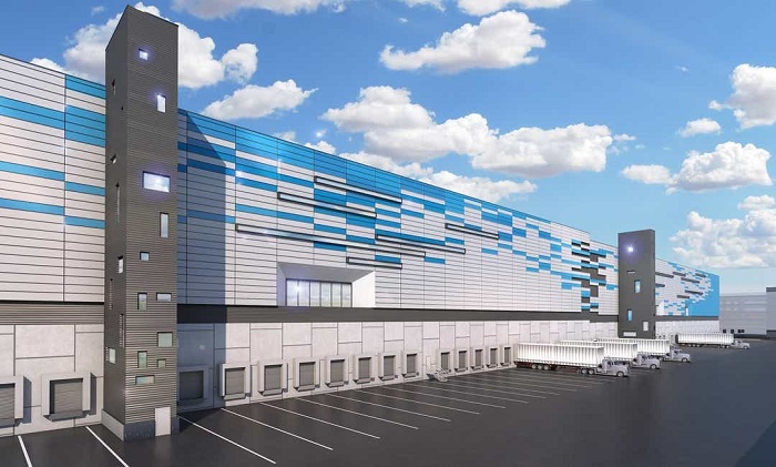
Amazon’s expansion of its e-commerce logistics network, giant distribution and fulfilment centres, continues during the Covid-19 pandemic. Several new facilities are airport-adjacent and many are supported by tax breaks.
Online buying has surged during the Covid-19 pandemic. Confinement of American citizens to their homes under ‘shelter in place’ orders and closure of shops selling non-essential goods have been a gift to e-commerce firms with extensive home delivery networks. E-commerce spending in the US surged by 78% in May, with Amazon, Target and Walmart reporting soaring online sales. Amazon, expanding its market share to nearly 40% of all online sales, has been the biggest winner. The first week of July 2020 marked the twelfth straight week of over 60% year-on-year growth of customer spending on Amazon. And Amazon is consolidating its distribution dominance by adding to its existing large facilities at airports, strategically located in proximity to fulfilment centres (warehouses for receiving and processing orders). A fleet of trucks, estimated to number over 20,000, delivers products and packages to urban centres.
Amazon’s surface shipping network is supported by Amazon Air (formerly known as Amazon Prime Air), a wholly owned subsidiary of the retail, e-commerce and logistics giant. Growth of Amazon Air is accelerating in 2020 and is a cornerstone of Amazon’s drive to challenge the dominance of FedEx, UPS and the United States Postal Service (USPS) in the overnight and 2-day home delivery market. Amazon’s fleet of cargo aircraft is anticipated to grow from 42 at present to 70 by 2021. A fleet of this size would place Amazon Air, its route network almost entirely within North America, among the world’s largest cargo airlines.
Amazon ‘super hub’ at CVG
A massive new air hub at Cincinnati/Northern Kentucky Airport (CVG) appears to be the lynchpin of Amazon’s expansion of domestic deliveries across the US. The new facility is expected to handle 200 flights per day, becoming Amazon Air’s ‘super hub’. Construction has caused problems for neighbouring homes and business premises. For more than a year vibrations from blasting works during construction caused damage to buildings along with uncontrolled dust and noise. Two affected residents filed a complaint seeking to allow residents living within 1 mile of the site to file a class action lawsuit against the contractors building the air hub. A construction worker, Loren Shoemake, was killed in a accident on the site. $40 million in state and local tax incentives and an additional $5 million from CVG Airport were given to Amazon to develop the air cargo hub at CVG and the State of Kentucky built a new interchange on the Interstate-275 highway to serve the development.
Amazon’s growth is partly due to its agressive stragetegy for getting tax breaks. Amazon Tracker, created by Good Jobs First, a non-profit organisation focusing on government and corporate accountability, tallies tax breaks and other subsidies given to Amazon for warehouses, other distribution network facilities and data centers. At the time of writing the total amounted to $2,982,000,000. Amazon facilites at airports benefitting from subsidies include hubs at Lakeland in Polk County, Florida and Will Rogers World Airport, Oklahoma, and distribution centres at Charlotte Douglas Airport in North Carolina and Romulus, Michigan.
Charlotte City Council approved $13.4 million in incentives to Amazon to bring an Amazon facility to Charlotte Douglas Airport. Opening in September 2019, the distribution centre has a footprint of 855,000 square feet, about the size of 15 football pitches. An identically sized Amazon fulfilment centre, on 84 acres of land in Romulus, north of Detroit Metropolitan Airport, was granted a $5 million state subsidy from the Michigan Strategic Fund in 2017. In addition $13.5 million of Michigan tax dollars was allocated for infrastructure around the site. The director of the Detroit Regional Aerotropolis Development Corporation said Amazon would attract other transportation and logistics firms to vacant property near the airport. Efforts to develop 6,000 acres of land within Detroit Regional Aerotropolis began in 2007 but never took off.
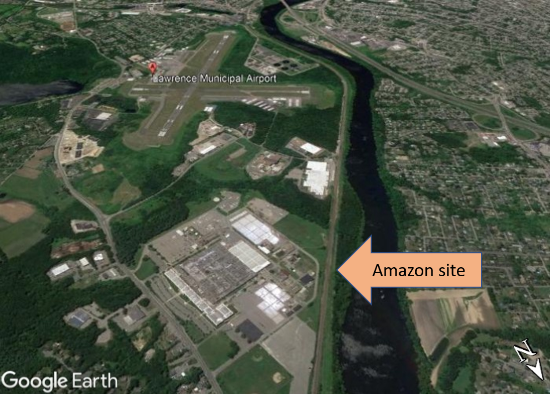
During 2020 Amazon has continued expansion of its surface shipping network, constructing and leasing massive warehouses across the US, in several instances supported by tax breaks and state funding for associated road infrastructure. In June 2020 the town of North Andover, Massachusetts, approved an estimated $27 million in tax incentives to Amazon for a massive 3.8 million square feet, five-storey high distribution centre. A tax increment finance agreement will reduce Amazon’s property tax bill for a decade. The amount is almost equal to the combined total of tax breaks previously granted to the company for other facilities in Massachusetts in the past few years: $16 million in state and local tax incentives for a large distribution centre in Fall River, an estimated $3.5 million for a sortation centre in Stoughton and up to $10 million in property tax breaks from the city of Boston for new offices in the Seaport District. The 110 acre North Andover site, formerly an industrial complex, is adjacent to Lawrence Municipal Airport with easy access to two interstate highways, the I-495 partial beltway around Boston and the I-93 arterial road extending from southwest Boston to St. Johnsbury, Vermont.
Site of new Amazon distribution centre in North Andover, Massachusetts
Over in Ohio construction of an Amazon fulfilment centre with a 2.8 million square feet footprint in Rossford, Wood County, was nearing completion by the end of June 2020. Interior works on robotics and HVAC (heating, ventilation and air conditioning) were underway and the scope of the project had expanded; 300 parking spaces for tractor-trailers in initial designs had increased to 719. Also in Ohio, state funding for a road project in Etna Township, Licking County is related to an Amazon building. One of the biggest speculative developments in the country, the footprint is reportedly 1.2 million square feet. The 15th June 2020 meeting of the Ohio Controlling Board approved release of $800,000 in support of the Amazon project, to extend a road “needed for basic access to the facility.” The 85 jobs that will be created by the road project come at the expense of a hefty subsidy: $9,411 per job. State largesse for Amazon was the polar opposite of swingeing $850,000 cuts to the nearby Southwest Licking School District, part of statewide budget cuts announced in May.
Map showing site of Amazon speculative building in Etna Township and road funded by Ohio Controlling Board. Source: Newark Advocate, 11th June 2020
More Amazon facilities in California
Imminent opening of a large new Amazon distribution centre at Meadows Field Airport in Kern County, California – a four floor facility with a footprint measuring 640,000 square feet – was announced in June 2020. Kern County agreed to give Amazon $3 million in local tax rebates in 2018, a subsidy package that would award the company annual refunds of approximately $275,000 for more than a decade.
Speculation that Amazon is developing a western hub at San Bernardino Airport was confimed on 8th May 2020 when the tenant of a major new air cargo facility was announced and the project named Amazon Air Regional Air Hub. Up until this point the tenant of what had previously been called the Eastgate Air Cargo Facility had not been disclosed. Amazon has already built 14 giant fulfilment centres in the San Bernardino and Riverside communities, known as the Inland Empire and one of the biggest hubs for goods warehousing and distribution in the US. High levels of air pollution from logistics traffic is compounded by geography; the area sits in a valley between two mountain ranges, forming a bowl trapping pollutants and emissions drift inland from Los Angeles. Several studies link poor air quality to health problems.
Eastgate Air Cargo Facility site plan showing distribution and office building, aircraft parking areas, dock doors, parking and operational support areas. Source: Environmental Science Associates, Inc., July 2019
More air cargo flights at San Bernardino Airport will bring more trucks, more traffic and more pollution. Specifications for the air cargo facility include two new driveways into the site with two new bridges crossing the City Creek Bypass Channel. Hundreds of local residents attended meetings to raise concerns over pollution from air cargo flights at the new San Bernardino Airport facililty and the projected 1,568 diesel-fuelled truck trips per day. A coalition of residents, community organisations, labour unions and churches united under the San Bernardino Airport Communities banner to push for good jobs during construction and operation and protection from air pollution, noise and road traffic impacts.
Two local community groups in Sonoma, Northern California, called for public input on a proposal to lease a vast warehouse to Amazon for its North Bay delivery hub project, questioning whether the turning the space into a major regional delivery centre violates the terms of the permit for the building. The property is zoned for light manufacturing, research and development, warehousing and distribution or retail/office use. Norman Gilroy of Mobilize Sonoma and Kathy Pons of the Valley of the Moon Alliance raised concerns that operation of a major regional delivery centre will increase intensity of the building’s use, without planning review or public comment, enquiring about the number of vehicles that will enter and leave the building on a typical day. The facility is anticipated to open in the autumn. In June 2020 neighbouring residents, concerned when they noticed a large crane at work, alerted county officials. An inspector verified that no permit for the work existed, leading to issuance of a ‘stop work’ order and a fine.
Houston, Florida, New York, Connecticut
Construction of a massive Amazon warehouse just southwest of Houston began in June 2020. The new fulfilment centre, on a 93.5 acre site, will have an 855,000 square feet footprint. Amazon built its first facility in the area, in north Houston, a few years ago, receiving a 10-year tax break from Harris County that was expected to save the company $180,000 annually. Elsewhere in the Houston area Amazon also has a fulfilment centre in Brookshire and a sorting facility near George Bush Intercontinental Airport. In central Florida the aforementioned Amazon air cargo hub at Lakeland Linder Airport is taking shape, a 300,000 square foot, three storey building taking up 47 acres of airport land. Then in July Amazon secured approval to build what might be its largest distribution facility in South Florida, near the Homestead Air Reserve Base in south Miami-Dade.
Site of new Amazon distribution centre in Miami-Dade
In New York, work on Amazon’s 450,000 square foot last mile facility in Bloomfield, Staten Island was deemed essential construction during the Covid-19 pandemic. Amazon already has a facility in Staten Island, an 855,000 square foot distribution centre opened on the West Shore in 2017. On 23rd June Amazon inked an agreement to lease space for an even bigger facility in Queens. A disused containerboard factory will be demolished and replaced with a massive 1 million square foot four-storey warehouse which will be the largest in New York City. Simultaneously, steel girders were being erected for an Amazon distribution centre in Clay, a town in Onondaga, a northern suburb of Syracuse. Upon completion, scheduled for autumn 2021 in time for Christmas deliveries, the five-storey, 3.8 million square foot facility will, in term of floorspace, be one of the largest in the world. Jobs will be created, but mainly for robots. Employing just 1,000 people it will be one of Amazon’s most automated sites. Little remains of the golf course that previously occupied the site, for 73 years. Onondaga County Industrial Development Agency approved $70.8 million in tax breaks for this Amazon distribution centre project.
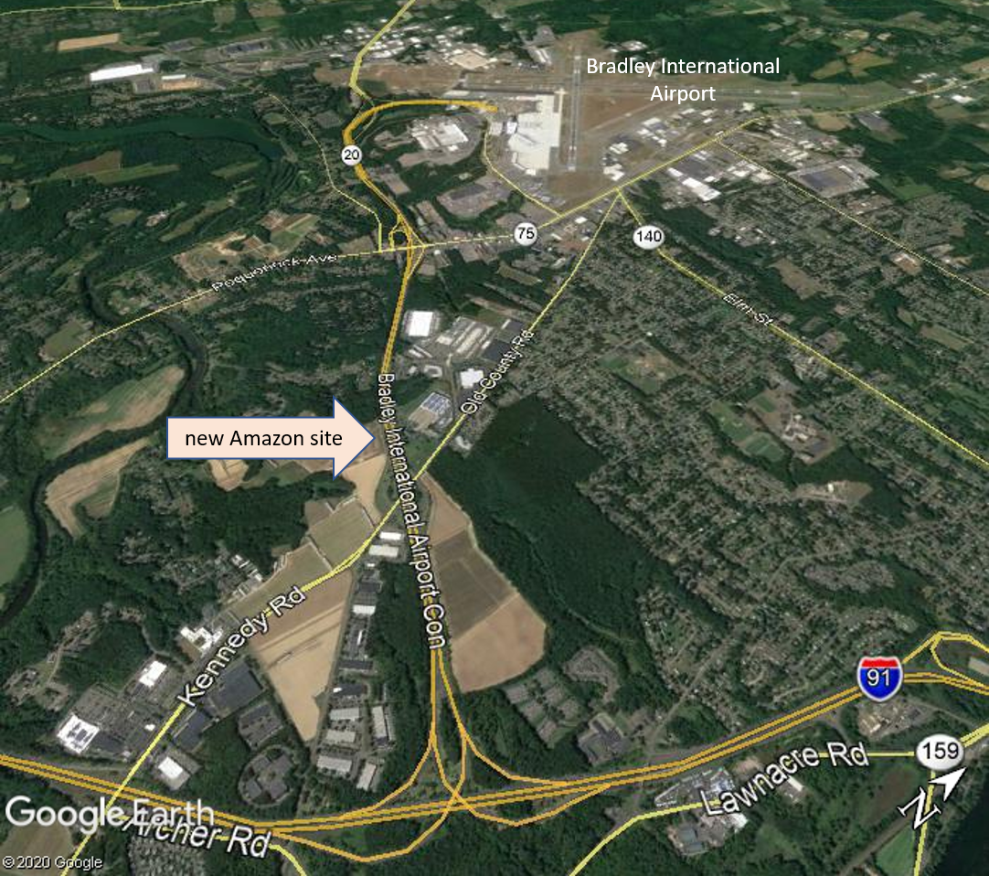
On 26th May 2020 a second Amazon warehouse/distribution centre in Windsor, Connecticut received local land use approvals. The 147 acre hub will be built on former tobacco farmland. Amazon, aiming to start construction in the third quarter of 2020, sought multi-year tax breaks for the development. Windsor’s economic development commission obliged, recommending approval of a seven-year 100% cent tax abatement. The site is on the Bradley Airport Connector highway connecting Bradley Airport with Interstate-91, the major north–south transportation corridor in central Connecticut.
Map showing site of new Amazon warehouse in Windsor, Connecticut, next to Bradley International Airport and connector highway
The tax breaks for the new Amazon facility, approved by Windor town council, were more modest than had been suggested: a three-year 50% abatement of real property taxes plus a 50% reduction in building permit fees. Amazon is projected to net savings of $8.78 million from the deal. Good Jobs First expressed its opinion on granting tax incentives to Amazon in a tweet:
Town gives $8.8 million in incentives to #Amazon, which had already started construction on the fulfillment center being subsidized. It's economic development malpractice to subsidize a project you've already landed. https://t.co/2xGkARQ6A0
On 22nd June Amazon decided to open two distribution centres in the south suburbs of Chicago, in Matteson and Markham, each measuring 855,000 square feet and anticipated to employ 1,000 people. The low employment density ratio is partly due to automation; the facilities will use ‘the newest generation of Amazon robots’ to pick, pack and ship goods. Several officials said Amazons’ decision to locate the warehouses in Matteson and Markham strengthened the case for proceeding with the long proposed south suburban airport in Peotone, as an air cargo hub. The new Amazon facilities are within a few miles of the airport project site. Government funding for road construction linking to the airport site is already allocated: more than $205 million from the Rebuild Illinois infrastructure plan for construction of Interstate 57 (I-57) related to the airport property. David Greising, president and Chief Executive of the Better Government Association, wrote that area would be better served with road and bridge upgrades serving rail and trucking routes than by ‘sinking $205 million into an “airport to nowhere” off I-57 toward Peotone’.
A third major Chicago region airport, on farmland in Peotone, has been proposed since the 1980s. Illinois Department of Transportation started buying land surrounding the site in 2002, amassing 5,000 acres of the proposed 6,000 acres for the ‘inaugural footprint’ for the airport. Farmer Judy Ogalla, who owns land in the proposed airport site where she grows corn, soybeans and wheat, said “We have great soil…It doesn’t have any sense to pave over that when we have an airport in Gary.” Kevin Brubaker of the Environmental Law and Policy Center said construction of the airport would destroy 1,200 acres of flood plains and 180 acres of wetlands. Opposition to Peotone airport has been sustained by Shut This Airport Nightmare Down, a group composed of environmentalists, farmers and other residents.
Amazon’s cloud cluster, data centres housed in another set of ubiquitous grey warehouses, casts an ever heavier earthly footprint. Already Amazon operates more than 50 data centres in Loudoun County, Northern Virginia, the largest single concentration of corporate data centres on the planet. Amazon seeks to expand this by building a massive, 2.5 million square feet, data centre campus south of Dulles Airport. This is one of five potential Amazon data centre projects being developed as the cloud cluster becomes a ‘cloud corridor’. Amazon and its development partners have been land banking, buying parcels of land for future development, adjcacent to Dulles Airport. Some Loudoun County community members are critical of data centre design and location. Over 100 data centres lining major roads dominate the visual landscape and lead to tensions over noise in residential neighbourhoods.
A plan for a major city extending over up to 600 square kilometres around a new airport in Navi Mumbai diverges from the aerotopolis model of development; the land area and number of villages included in the jurisdiction has reduced.
NAINA (Navi Mumbai Airport Influence Notified Area) originated when the Indian government granted clearance for a second Mumbai airport, in Navi Mumbai. One of the conditions for approval of the new airport was ‘that the Master Plan, Development Plan of Navi Mumbai shall be revised and recast in view of the Airport development and to avoid unplanned haphazard growth around the proposed airport’. Factors considered in assessment of the Influence Zone around the new airport included ‘the requirements of International Airport as per the aerotropolis concept’, connectivity and operation of various planning authorities in the region. Appointment of a ‘Planning Authority for a Planned and orderly development within a radial distance of about 25km from the proposed International Airport site’ was deemed necessary. On 10th January 2013 City and Industrial Development Corporation (CIDCO) was appointed as the Special Planning Authority.
Even at this stage it was evident that NAINA (the pink shaded areas on the map) diverged from the aerotropolis model of development. The designated NAINA area was fragmented and not even contiguous with the Navi Mumbai International Airport site (shown on the map as an orange rectangular area to the west of NAINA). The new jurisdiction, encompassing 270 villages in six talukas in the Raigad and Thane districts, a mix of peri-urban and rural areas, was not the recilinear greenfield site of an archetypal aerotropolis.
A large land area was designated for NAINA, estimated at between 550 and 600 square kilometres (1.5 times larger than the city of Mumbai). Inception of NAINA transferred planning powers to CIDCO; notification specified that all proposals for development permission would henceforth be processed by CIDCO. Land acquisition for the initial phase met with opposition. In 2014, while a survey was being undertaken, residents of the 23 villages notified for development in phase 1 of NAINA (to the east of the Navi Mumbai International Airport site) voiced strong objection saying they were not informed about the project which would adversely affect agriculture, their main source of income.
A spokesperson for the 23 villages said people did not trust CIDCO because farmers who lost their land in the 1970s, for development of Navi Mumbai city, had still not been compensated. Affected families had been promised employment but many were still doing odd jobs to make ends meet. Villagers also raised objections to CIDCO’s practice of providing information in English, a language most of them did not understand. A hearing was rocked by protest and villagers claimed that developers’ land was being treated preferentially, left untouched while theirs was earmarked for public utility purposes.
In an article published in Economic & Political Weekly ‘Fragmentary Planning and Spaced of Opportunity in Peri-urban Mumbai‘ Malini Krishnankutty describes how the Interim Development Plan (IDP) prepared for the first phase of NAINA, encompassing 23 villages, ‘reinforces the planners’ lack of deep engagement with the rural’. NAINA’s role of amassing land for implementation of its master plan exemplified modern urban planning’s disregard for rural areas. Such planning interventions viewed land merely as a resource, the rural as a ‘tabula rasa’ destined for urban development, villages from ‘the narrow perspective of providing very specific social amenities or transport infrastructure’, thus rural villagers and their ways of life were rendered invisible. With regard to NAINA she writes:
‘Once again what is visible here is a superimposition of a vision of a city on these villages, a view of urbanisation that is a foregone conclusion, and a lack of engagement with the future of the villagers, once they are divorced from their lands and livelihoods. There is also no engagement of planners with any idea of conservation, tangible or intangible or of productive farmlands’.
NAINA’s proximity to the Navi Mumbai International Airport site had given impetus to speculative interest in the area. The airport and several major road and rail projects in the pipeline – Mumbai Trans Harbour Link (MTHL), Delhi-Mumbai Insustrial Corridor (DMIC) and a road + rail corridor extending from Virar to Alibaug linking peri-urban regions in the Mumbai Metropolitan Region (MMR) – all require land acquisition by the government that ‘inevitably means dispossession and loss of livelihoods’. In addition these infrastructure projects activate the ‘highway urbanisation’ that is prevalent throught India and the global south. Announcement of new infrastructure triggers commodification of land, opening up rural areas for urban development.
During June, July and August 2015 journalist Rahul Batia travelled along the path of the Virar – Alibaug road and rail corridor running through NAINA, talking with people affected by land acquisition for the project. The route of the road, a transportation corridor 126 kilometres in length and 120 metres wide, stretches from the city of Virar to the north of Navi Mumbai, running southwards through NAINA then curving easwards to the coastal town of Alibaug. On the interim development plan the transportation corridor appeared as ‘a thick white strip snaking through residential areas, growth centres, forests, and urban villages’. Twelve kilometres of the road were within NAINA phase 1 and impacts upon the 23 villages within this area loomed.
NAINA map showing route of road through Nere and other villages. Source: cidco naina
The poorest locals were the most perturbed by the ‘corridor of uncertainty’, believing it would ‘hit them hardest’; some were convinced that they had been ‘singled out for some kind of punishment’. There were allegations that the route being marked out for the road curved to avoid homes and land owned by rich and influential residents. Adivasis at a hamlet in Nere, one of the affected villages, came across a mark painted into an approach road and thought it was connected with the new transport corridor. The sarpanch (head of village) of Nere knew little about the road except that people would be relocated to make way for it, and did not know where they would go to. He had not seen the map of NAINA. Pointing out a notice with a yellow diagonal stripe marked ‘CH 51554’ he said, “They came here, made markings, and left. Nobody told us anything.” Inhabitants of the 23 villages in the first phase of NAINA lived in uneasy uncertainty. NAINA officials were holding consultations but many affected residents complained of a ‘disconcerting lack of information available about exactly what shape NAINA will take’ and said that rates for people wanting to build on their land were ‘exhorbitant’.
Opposition to land-pooling scheme
Unrest over NAINA plans continued into in 2016. In February farmers of 111 villages opposing NAINA united to form a committee, Shektari Utkarsh Samiti, and marched from Khargar to Panvel. They voiced many demands for changes to NAINA policy, including that the amount of their land to be given to CIDCO under the land pooling scheme, whereby groups of land owners hand over their land to a government agency for development of infrastructure, with a proportion of the land being returned to the landowners, be decreased from 40 per cent to 30 per cent. In September representatives of 36 villages in the Panvel taluka (administrative district) immediately to the east of the Navi Mumbai International Airport site, said they did not want to be part of NAINA and wished to be excluded from the plans and instead be included in the Panvel municipality. Together these villages cover 69.6 square kilometres, a substantial proportion of the total NAINA area.
Rajendra Patil, a representative of one of the villages, Kolkhe, said that waiting for finalization of NAINA plans had stalled development in their villages, and that the development model was tilted in favour of big developers whilst working against the interests of local farmers. Anesh Dawale, a former head of Shivkar village, said of NAINA’s land pooling scheme: “It is just a garb to release farm lands held by villagers to the builder lobby”. In particular, local people were of the view that the minimum land pooling norm of 18 acres favoured construction magnates. Dawale also said that the curbing of village council powers under NAINA had a negative impact on civic services, a view shared by Panvel’s MLA (Member of Legislative Assembly), Prashant Thakur.
In December 2016 it was reported that 14 villages on the outskirts of Navi Mumbai and included in NAINA feared losing their land due to the project. Community representatives said that authorities were reserving plots of land without consulting local people and that inclusion in NAINA was blocking development in their villages, in contrast with surrounding areas that were flourishing. The 14 villages repeated demands first made in July 2015 to be merged with the civic body NMMC (Navi Mumbai Municipal Corporation) instead.
NAINA area reduced
NAINA was described as ‘potentially the biggest smart city in India‘ at approximately 600 square kilometres in November 2014 but by May 2016 CIDCO appeared to favour polycentric urbanisation, in the form of ‘30 smart cities‘, Special Economic Zones and growth centres. CIDCO officials estimated that, in its initial years of operation, the new airport would handle two to three million passengers, a fraction of the widely publicised projection of 20 million passengers per year in the first phase, rising to 90 million when expanded to full capacity. By July 2017 many parcels of land in the 1st phase of NAINA had not been acquired due to opposition from villagers. The state urban development department had approved development of the 23 villages three months previously but the development plan was still not publicly available.
Map of NAINA, reduced to 474 sq km, September 2017. Source: CIDCO
CIDCO’s Modified Draft Development Plan for NAINA, published in September 2017, anticipates an inflow of passengers from the new airport, but there is no mention of mulitiple millions of passengers annually. The plan does not include the aviation-dependent tourism or freight facilities that form the mainstay of an aerotropolis. The plan details a substantial reduction in NAINA’s footprint and a map shows further fragmentation of the designated areas. Several villages were transferred to other jurisdictions, becoming part of Maharashtra State Road Development Corporation Limited (MSRDC – a development plan for the area along the Mumbai-Pune Expressway), Matheran Eco-Sensitive zone (MESC) and Maharashtra Industrial Development Corporation (MIDC). Thus the number of villages incorporated in the NAINA plan decreased to 224 and the land area was reduced to 474 square kilometres.
The voluntary land-pooling scheme was causing delays, so, in April 2018, at the request of CIDCO, the state government moved to fast-track the NAINA project by way of invoking town planning scheme (TPS) provisions for compulsory participation of villagers residing in areas encompassed in the development plan. Participation in the project was made compulsory for the 23 villages in Phase 1 of NAINA. A draft plan for this 37 square kilometre pilot area was published, giving villagers just 30 days to make suggestions and objections, enabling CIDCO tosanction the scheme in three months. CIDCO also moved to expedite road building, using a fast-track TPS process, allowing a total of 21 months from announcement to execution.
Diverting water to NAINA
NAINA will take up water as well as land. CIDCO’s September 2017 Modified Draft Development Plan for NAINA calculates NAINA phase 1 water demands to be 8.33 MLD (millions of litres per day) in 2021, rising to 29.75 MLD by 2031 then reaching 45.07 MLD by 2041. New sources of water are anticipated to meet the increasing demands of NAINA and other CIDCO projects: the Balganga dam from which 150 MLD would be available for NAINA and Khopta Area (another CIDCO project) and the proposed Kondhane dam from which CIDCO expects to receive 250 MLD. The state transferred the Kondhane dam project from the water resources department to CIDCO in August 2017. The dam will draw water from the Ulhas river.
Shortage of water supplies is a perennial problem in many areas of Mumbai. In 2018 water scarcity was exacerbated by construction activity for Navi Mumbai Airport, which put pressure on water supplies impacting on surrounding communities, including those within NAINA. By May 2018 Panvel had been suffering a severe water crisis for three months. Every summer water scarcity forced residents to rely on water tankers. But in 2018 the situation was more serious. Many areas in Panvel were only receiving water on alternate days. Villages under NAINA were only getting water every three or four days. A resident of Khanda colony, Vishnu Gavali, filed a public interest litigation (PIL) requesting the court to direct civic authorities to resolve the issue. The PIL states that, under the constitution, all citizens have the right to food, water and a decent environment, and that CIDCO was failing in its duty to provide basic amenities. Gavali said “As airport work has started, a lot of water is being used for the construction activities but sadly, the locals have been neglected.” A resident of Roadpali said “Cidco has given permissions for so many upcoming projects in the city, I don’t understand how they would fulfill water needs of so many projects.”
In March 2019 residents of Panvel gathered near the CIDCO water tank premises in protest over poor and erratic water supplies, denying their fundamental rights to a basic amenity. Leader of the delegation, Apoorva Prabhu, said they had suffered water scarcity for six months and were requesting regular water supplies of least two hours daily. In September 2019, with many areas facing water shortages, CIDCO took measures to ensure that NAINA would not be affected by the water crisis. A detailed project report (DPR) on Kondhane dam, to help ensure adequate water for NAINA, was expected to be completed within a year and revive the project.
Objections to NAINA plans
On 28th June 2019 the Times of India reported that the urban development department would publish the final approved plans for NAINA and Maharashtra State Road Development Corporation Limited MSRDC after the monsoon season. Citizens demanded the government publish the report of the planning committee on the objections and suggestions made by the public in order for there to be transparency over whether or not these concerns raised were addressed or not. Pankaj Joshi, architect and executive director of the Urban Design Institute said “Objections were raised to the government proposing industries in green zones in the metropolitan regional plan. The entire green belt will become brown if it is approved.”
Map of NAINA September 2019, area shrunk to 371 sq km. Source: Times of India
By September 2019 NAINA, promoted as India’s largest planned city in 2014, had shrunk to just over half its original size. The plan for a new city, spread over up to 600 square kilometres of land, had shrunk substantially, now occupying a 371 square kilometre plot. The map indicated further fragmentation of the NAINA area and the number of villages incorporated in the plan had reduced from 270 to 175. The most recent government notification granted sanction for the development plan for the remaining 152 villages covering 334 square kilometres, along with the 23 villages included in the 37 square kilometres allocated for phase 1.
Unrest among farmers affected by land acquisition for NAINA was reported again in January 2020. A protest against CIDCO had already taken place and farmers were planning further agitation. Several local leaders were raising their voices against the scheme. By 17th March CIDCO was reportedly ‘going ahead aggressively’ with implementation of NAINA, in the face of unrest by impacted people. About 10,000 farmers from the 23 villages of the first phase of NAINA were planning a demonstration. The farmers alleged that the town planning scheme was not beneficial to them and demanded a review. Vaman Shelke of NAINA Prakalpbadhit Shetkari Utkarsh Committee (NPSUC) said they were given notice if carrying out any construction work on their land, leaving them with no option but to accept the scheme. “This is a participatory scheme and we cannot be forced to join” said Shelke, explaining that farmers were demanding return of 50 per cent of developed land under the land pooling scheme instead of 40 per cent, along with additional benefits for loss of their agricultural land.
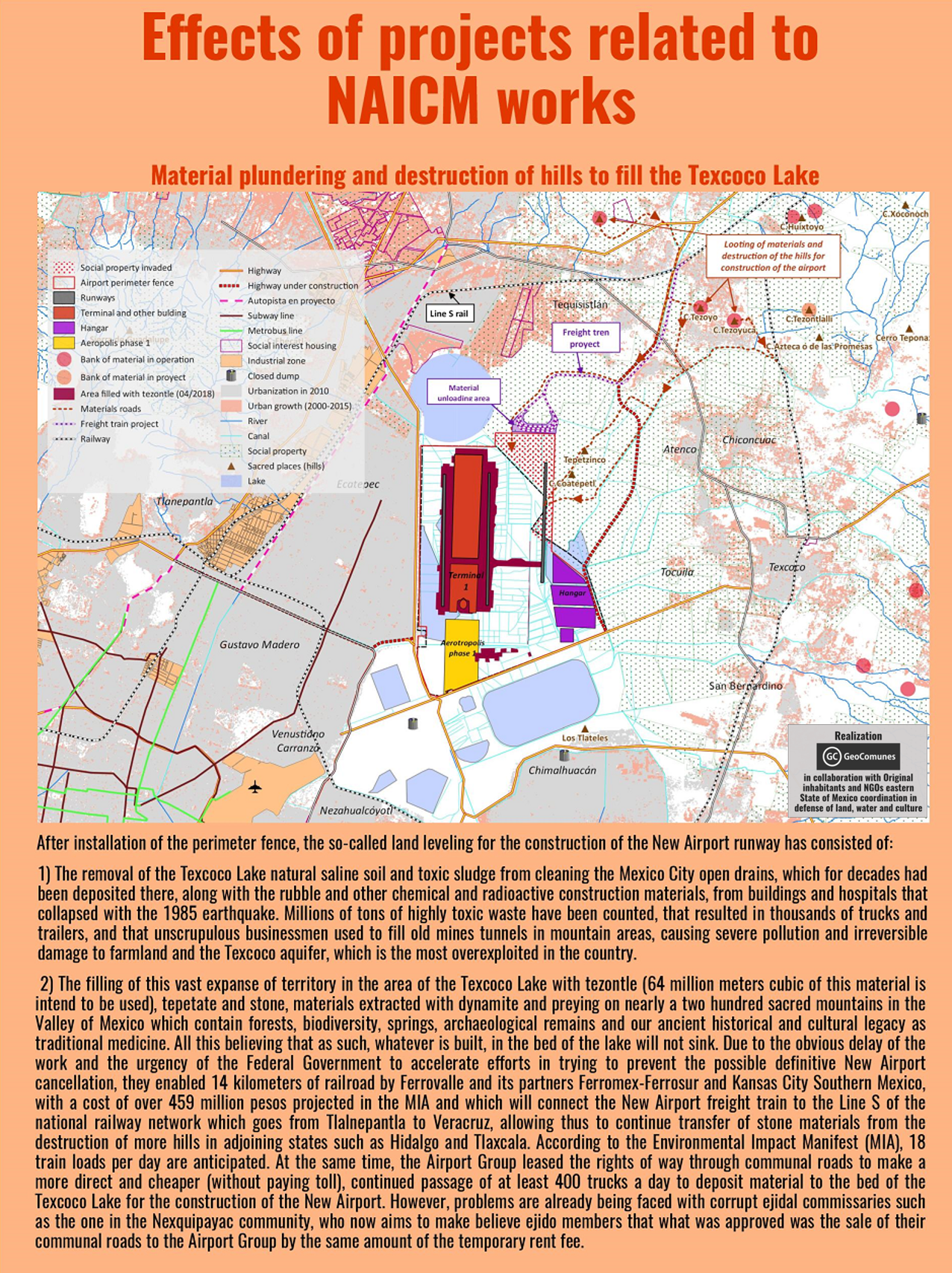
GAAM is delighted to share an incredibly informative set of maps elucidating the complex socio-economic and environmental impacts of construction of New Mexico City International Airport (NAICM). The maps were produced by GeoComunes, a collective working with communities to use maps as an analytical tool to strengthen the struggle for defence of common goods, in collaboration with affected residents and NGOs supported by Coordinadora de Pueblos y Organizaciones del Oriente del Estado de México (CPOOEM), which supports people’s defence of land, water and culture in eastern Mexico. The NAICM site, covering over 4,431 hectares, is the waterlogged Texcoco lakebed. Aerotropolis development is planned: a specific area within the airport site and commercial and industrial development over an extensive area surrounding it.
The first map, below, shows uncontrolled urbanization between 2000 and 2015, preceded by highway expansion, driven by real estate and encroaching on ejidos (communally held agricultural land) near the shores of Texcoco Lake. Landfill sites receiving waste from Mexico City have damaged farmland and polluted aquifers. The airport site is in the ‘Zona Federal’ area in the centre of the map. The existing Mexico City International Airport (officially named Benito Juárez International Airport) is shown near the bottom of the map.
A perimeter fence has been erected around the NAICM Phase 1 project area. The site includes ejidal lands, in spite of assurances that the airport would be built entirely on federally-owned land. Ejidal lands were also appropriated for a highway and housing developments, and many Ejidos (land holders) were violently evicted by state security forces. Plans for Aerotropolis phase 1 include a shopping mall, hotels, industrial park, exclusive high-end housing, golf courses and a free trade zone.
The third map shows satellite imagery of the three Ejido areas directly affected by airport construction. Over 330 hectares of ejidal lands, in the communities of Ixtapan, Nexquipayac and Atenco, were seized from its rightful owners by the government and now lie within the NAICM perimeter fence.
Land-levelling to prepare the site for construction of the airport involved clearing saline sludge from the lakebed and toxic waste that has been dumped, polluting the Texcoco aquifer and damaging farmland. Extraction of materials for use in has had a devastating impact on sacred mountains, in the Valley of Mexico. Blasting with dynamite has damaged, forests, biodiversity, springs and archaeological remains. It is estimated that 64 million tonnes of tezontle (red volcanic rock) along with stone and other materials, carried on 400 trucks per day, will be deposited to fill in the Texcoco lakebed.
Water drained from the Lake Texcoco area will be channelled into Nabo Carrillo, an artificial lake and newly created lagoons, along with water from the area east of the airport site channelled via several culverted rivers. Lying at the bottom of a downward slope the airport site is at risk of flooding from concentration of water flow in this area. The flood risk could become more severe as Texcoco lakebed is sinking at a rate of about 12 inches annually.
An extensive road network linking NAICM to key urban centres is planned and under construction, encroaching on ejidal land and opening up additional land for real estate and commercial development. Many of the roads are toll roads which will generate profits for construction firms holding the concessions and thus set to benefit from the traffic flow.
Data from all the maps is combined in the final map, which covers a wider geographical area revealing the extent of the urbanization that is underway and planned. See the larger version of the map for more detail. NAICM is shown within a wider context as the most important of, and the focal point for, a series of megaprojects combining to form a ‘Megalopolis’, an agglomeration of cities and other urban areas. New road and rail corridors will foster further real estate development. Mexico City already suffers chronic water shortages and springs and groundwater are over-exploited. The current model of urbanization will increase stress on water supplies and aqueducts are planned to access more distant sources.
All the maps of NAICM and aerotropolis plans can be seen here in their entirety and are best viewed on the largest computer screen that you can find so you can zoom in and see the intricate detail.
Approval of plans for Bulacan Aerotropolis in Manila Bay, one of the biggest megaprojects in the Philippines, threatens 700 families with displacement and loss of their fishing livelihoods. Thousands more fisherfolk would be affected by land reclamation for the 2,500 hectare airport and ‘airport city’ complex.
On 25th April the National Economic and Development Authority (NEDA) of the Philippines approved plans for a new airport and metropolis, i.e. an aerotropolis, in Bulacan province, Manila Bay. Residents of the village of Taliptip and seven other areas will be affected by the project and at least 700 families face displacement. They make their living from selling their fishing catch in a nearby town and from making fishing nets. Their income is low but life is good and they do not want to leave. A woman who has lived in Taliptip for 43 years is worried for the future of her children and grandchildren. They were not informed about the airport plans and have been told they will be relocated, but not where, or how they might make an alternative livelihood.
Local communities resisting loss of their homes and incomes for the airport project are being supported by environmental and church groups and people can follow the local people’s struggle on the Save Taliptip Facebook page. Leon Dulce, national coordinator of the Kalikasan-People’s Network for the Environment, writes that the Bulacan aerotropolis plan is being pursued aggressively and was kept hidden from Taliptip residents until news broke of President Duterte’s approval of the project. The seas surrounding Taliptip support the livelihoods of about 5,000 fisherfolk and salt-makers, who face being displaced for the project.
Living in hardship has made Taliptip’s people resourceful, they live off the grid using solar power and batteries for their modest electricity needs. The fishing catch has dwindled but they are determined to remain in their homes maintain their established communities. A fisherman from Sitio Kinse, an island community in the midst of the mangroves along the shoreline said: “So long as the sea is here, there is hope … What will we fish if all this were turned into cement?” Fisherfolk take care of mangroves, a vital habitat for many bird species including egrets, terns, kingfishers and swallows, along with shellfish living among its roots. At the beginning of May there was a ‘massive mangrove cutting spree’ in Taliptap, reportedly undertaken by SMC, possibly without the required environmental clearance and thought to be connected with Bulacan aerotropolis. On 12th May Pinoy Weekly posted a photo of Taliptip mangroves that had been cut.
LOOK: Several trees of api-api, a species of mangrove, were cut in Brgy. Taliptip Bulakan, Bulacan. San Miguel Corp. was recently awarded by DENR an original proponent status to build a P700-B aerotropolis in Brgy. Taliptip. pic.twitter.com/aWfjsemSvi
National fisherfolk alliance Pamalakaya also opposes the new airport. Chairperson Fernanado Hicap said the project will cause environmental disaster in Manila Bay; destruction of marine ecosystems would threaten the livelihoods of more than 20,000 fisherfolk in Bulacan and neighbouring towns. Hicap also lambasted the broader Build, Build, Build (BBB) infrastructure development programme that the new airport is part of, for selling coastal waters and public lands to large developers and foreign investors. Constructing an airport in Manila Bay would require extensive land reclamation works, creating new land from the sea and wreaking destruction on fishing grounds.
Developers and governments often opt for land reclamation, as an alternative to building on farmland and obviating the loss of productive agricultural land and displacement of rural communities. But dredging up vast volumes of sediment from the ocean bed exacts a terrible ecological toll; ecosystems including mangroves, coral reefs and coastal flats are eradicated when sediment is dumped on top them. The new airport is just one of five land reclamation projects Duterte’s administration has approved in Manila Bay, described by Hicap as disregarding the “socio-economic rights of hundreds of thousands of fisherfolk and coastal settlers”. Land reclamation for the Bulacan airport project is likely to impact not just on the town of Balakan but on the neighbouring towns of Hagonoy and Paombong and the city of Malolos.
A mega-airport and a new metropolis
A mega-airport is planned, with six parallel runways and initial capacity for 100 million passengers annually, more than double the passenger throughput at the existing main Manila airport, Ninoy Aquino International Airport, the busiest in the Philippines. With a budget of P735.63 billion (US$14.2 billion) the new airport in Bulacan is the country’s most expensive transport project to date, by far the most costly of eight infrastructure projects approved as part of the Build, Build, Build (BBB) programme on 25th April by the National Economic and Development Authority (NEDA) Board, chaired by President Rodrigo Duterte.
San Miguel Corp (SMC), the Philippines’ biggest company by revenue – a conglomerate with interests spanning infrastructure, real estate, mining, petroleum, power and food & beverages – is set to build, operate and maintain Bulacan airport and aerotropolis. The plan spans 2,500 hectares, comprising 1,168 hectares allocated for the airport and 1,332 hectares for an adjoining ‘airport city’. The video below includes a graphic showing the basic layout.
SMC’s unsolicited proposal to build Bulacan Airport, revealed after scrutiny by the Department of Transportation in November 2017, featured additional SMC projects, in the form of the obligatory surface transportation network that is inherent to the aerotropolis development model. An SMC-built expressway linking the airport to the North Luzon Expressway is planned, which would in turn link to SMC-backed Metro Rail Transit Line-7. By the time NEDA approved the Bulacan airport proposal in April 2018 the expressway project specified a revenue stream for SMC, an 8.4 kilometre airport toll road. NEDA gave SMC’s proposal for Bulacan airport the green light in spite of Department of Finance concerns that the project is to be implemented by SMC subsidiary San Miguel Holdings Corp, whose capitalization is smaller than the airport project.
Clark Airport – another aerotropolis, another new metropolis
Some potential Bulacan Airport investors were cautious about the project because expansion of Clark Airport could serve similar markets. NEDA has approved US$241 million expansion of Clark Airport as another priority under Build, Build, Build. Finance Secretary Carlos Dominguez highlighted Clark Airport growth at an Asian Development Bank briefing saying “Clark will will soon be the showcase of the Duterte administration’s economic strategy”. In December 2017 the government awarded the GMR-Megawide consortium the construction contract for trebling Clark Airport’s capacity from current 4 million passengers annually to 12 million by 2020. President and CEO of Clark Airport, Alexander Cauguiran, has stated larger-scale expansion plans, for increasing capacity to 80 million passengers annually upon completion of a fourth phase of development.
A former US military base which is already an economic hub, Clark Airport is also being developed as an aerotropolis, encompassed within a wider area already primed with surface transportation infrastructure and lavish incentives for investors. Clark Airport is part of Clark Freeport, a 4,400 hectare tax and duty incentivized area. Further development of Clark Freeport is prioritized in NEDA supported infrastructure projects; the US$957 million Subic-Clark railway, connecting to the Philippines other freeport zone, has been approved. Clark Freeport adjoins a larger area, the 27,600 hectare Clark Special Economic Zone, where firms can avail themselves of a generous suite of tax breaks including income tax and corporate income tax holidays of up to eight years and exemptions from local government taxes.
In April 2015, as the government infused P1.2 billion (US$27 million) for a low cost passenger terminal, it was reported that the government was ‘pouring investments into Clark aerotropolis’ development’. Nearly three years later, in March 2018, the Bases Conversion and Development Authority (BCDA) pitched Clark Airport to global investors as an ‘airport city’ and ‘growth center’. BCDA senior vice president John Bingcang said “Clark is on its way to becoming Asia’s next aerotropolis with the development not only of the airport, but the Clark Freeport as well” and invited investment in construction of a US$67 million access road to another airport city component, the “smart, green, and resilient” New Clark City. At completion covering an area of 93 square kilometres, planners envisage that New Clark City will be larger than Manhattan, housing 2 million people. Claims that the new metropolis will be sustainable, reduce carbon emissions and ‘pollution-free’, are undermined by aviation dependence. New Clark City is regarded by BCDA as complementing expansion of the airport.
Land disputes and displacement
Development of Clark Airport within Clark Freeport, in the 2,367 hectare Clark Civil Aviation Complex (CCAC), has triggered land disputes. In July 2016 117 farmers cultivating about 200 hectares of CCAC land appealed to President Duterte, drawing attention to their request to Clark International Airport Corporation (CIAC) to grant them ‘Disturbance Compensation‘. The president of a farmers’ cooperative said construction of factories and an industrial complex had begun without prior consultation. Farmers protested at the construction site, stating that they were willing to surrender farmlands but demanding just compensation plus reimbursement for loss of farm buildings and crops. Almost a year later, in June 2017, cultivation of grains, vegetables and spices in the CCAC appeared to be attracting birds. A Commission on Audit (COA) report blamed farming activities of people it referred to as ‘illegal settlers’ on 647 hectares of land for an increase in bird strikes, collisions with aircraft that can pose a safety risk.
GMR-Megawide is keen on bidding for the operation and management contract of Clark Airport, and already operates Mactan-Cebu Airport, the second busiest in the Philippines. A second terminal is scheduled to open within a few weeks and GMR-Megawide Cebu Airport Corp (GMCAC) plans for further expansion, a third terminal and second runway that would increase airport capacity from the current level of approximately 10 million passengers per year to 28 million passengers by 2039. The project entails reclaiming 300 hectares of Magellan Bay. This option, chosen in a proposal supported by some Cebu congressmen, was seen as preferable to expanding over land as that would have impacts upon between 10,000 and 12,000 households.
SMC, through its subsidiary Trans Aire Development Holdings Corp (TADHC) holds the concession to operate Boracay Airport, the main gateway to the Philippines’ most well-known tourist island. On 16th September 2015 residents facing land expropriation for expansion of the airport protested against plans to purchase their land at a fraction of its market value. The president of Caticlan Land Owners Association said the market rate for real estate in the area was between five and ten times higher per square metre than residents were being offered. Yet some residents had already received court orders instructing them to vacate their homes. Demonstrators gathered outside the airport terminal with placards reading: ‘No To Expansion Caticlan/Boracay Airport’, ‘Stop Harrassment’, ‘Airport Expansion is Killing us’, ‘Expropriation is Oppression’, ‘No to Expropriation, Yes to Fair Negotiation’, ‘CAAP / San Miguel Have Mercy ON US’ and ‘Government for the People, Not Government for San Miguel Corp’. About 200 families were affected by expansion of the airport and in November 2015 the Commission in Human Rights (CHR) in Western Visayas took cognizance of the complaints raised by landowners.
Some residents had no choice but to accept the low compensation offer. By April 2016 a number of families had been evicted to make way for airport expansion and become squatters. Local residents asked TADHC and the Civil Aviation Authority of the Philippines (CAAP) for clarification of the scope of Boracay Airport expansion plans, estimated to affect about 8,000 people. By October 2017 SMC was building a new terminal at Boracay Airport and, separate from airport development, expanding the footprint of its tourism related development on 130 hectares of land. Groundbreaking for a 400 room Marriott Hotel was imminent and plans included more hotels, an entertainment complex and an ocean park.
A plan for a new airport, one of the largest in the world on a 2,600 hectare site in the Kandal District of Cambodia, with an accompanying ‘Airport City’, has reignited one of the country’s fiercest land disputes.
In January the Cambodian government approved a plan for a new airport, one of the largest in the world by land area, on farmland in the Kandal Province, about 30 kilometres south of Phnom Penh. Construction of the new airport is anticipated to commence in 2019 and a 21st December 2017 document from the Council of Ministers approved an investment proposal from Cambodia Airport Investment, a joint venture between the State Secretariat of Aviation (SSCA) and Overseas Cambodia Investment Corporation (OCIC). OCIC is a private firm, one of the largest finance, infrastructure and real estate companies in Cambodia, owned by tycoon Pung Khiev Se, with a track record of financing major development projects.
The land area earmarked for the airport project, 2,600 hectares, is more than six times larger than the existing Phnom Penh Airport’s 400 hectares and considerably larger than Beijing Capital Airport, the world’s second busiest passenger airport, with a 1,480 hectare site and handling over 94 million passengers in 2016. Predominantly low-lying agricultural land, the proposed site is on the northwestern shore of a large lake, Boueng Cheung Loung. Preparing the lakeside area of the proposed site for airport construction would require land reclamation and it is thought that there is some overlap with the lake itself.
A map produced by GAAM shows the proposed airport site, based on a modified satellite image published in the Phnom Penh Post. The authors of the article were not certain whether the proposed airport site is state-owned or part of OCIC’s vast land bank. The rectangular area outlined in orange, measuring 1,000 hectares, appears to be allocated for the airport. The adjoining rectangular area, outlined in yellow, measuring approximately 1,800 hectares, appears to be earmarked for development of an ‘Airport City’, described by SSCA spokesman Sinn Chanserey Vutha as a mixed-use development including a commercial centre and residential housing. Chanserey Vutha explained that investors will not be able to generate a profit from the airport itself, so the land for the Airport City is being offered to investors for generating profits from commercial centres and other amenities.
Land rights protests as villagers fear eviction
Announcement of the new airport and associated development sent land prices soaring upwards and within days land for sale signs were hastily erected. Rice fields and lakeside properties in the area that had been valued at between US$20,000 – 50,000 per hectare before announcement of the new airport began selling for as much as US$100,000 or even US$200,000 per hectare. Kandal District villagers were shocked by sudden news of the airport project, along with publication of maps appearing to show the new airport and a massive multi-use development on land they have resided on and near for more than two decades. Their land ownership is disputed by a local ‘oknha’ or tycoon, Seang Chanheng, who has long laid claim to it. A government-aligned media outlet, Fresh News, released documents purporting to show that the land had belonged to Seang Chenheng all along, but even provincial authorities profess uncertainty regarding rights to the land. Regardless of this uncertainty, a large area of disputed land was recently purchased for the airport project, by OCIC in partnership with the SSCA.
Several communes in the Kandal Stung district are wracked by long-running land disputes; the airport project has raked up old tensions and new potential conflicts are looming. Already, there are indications that the authorities are siding with Chanheng’s company and criminalizing protest by villagers residing near the land earmarked for the new development. At the beginning of February over 100 villagers blocked bulldozers from digging a dam on disputed land adjacent to the proposed airport site. Subsequently, Kandal Military Police summoned six villagers to appear for questioning after Chanheng accused them of “incitement” and obstructing her machinery. Oeung Sary, one of the villagers called in for questioning, was undeterred by the order, saying “We will go to meet with the Military Police whether they arrest us or not, because we are fighting for our land…We have no guns or power to fight them with. If they want to jail us, let them jail us.”
On 19th February affected villagers staged a major protest. Over 200 people from four communes gathered at Kandal Provincial Hall to voice their complaints regarding land earmarked for the new airport and seek resolution of the dispute with Seang Chanheng. Oeung Sary remained defiant and determined to stay on the land. Refusing to appear before the military police she said “We will not go to answer. If they want to arrest us, let it be” and accused the government of “bias” in favour of Chanheng’s company. Another villager, Sorn An, said she was one of several villagers who had sold land, in her case belonging to her grandmother, to Chanheng’s company but been underpaid, selling it for $250 per hectare but receiving a fraction this amount, just $25 or $50. She said they had been intimidated during negotiation over the land, that representatives of the company had slammed the table in front of them, threatened them, locked the door and called the police.
Reigniting one of Cambodia’s fiercest land disputes
One of the fiercest and lengthiest land disputes in Cambodia has been reignited by the new airport project. Nearly 300 families living in three villages in the Kandal District, still bearing their Pol Pot era names of Point 92, Point 93 and Point 94, have resided in the area for more than twenty years. Before the residents settled upon it the land was uncultivated. Their ownership of it appears to be legitimate on the basis of a 2001 law that people living peacefully on uncontested land for five years can lay claim to it.
But in 2005 Chenheng’s men began bulldozing the land in order to claim ownership of it. The villagers achieved a rare legal victory in 2006-7 when the Kandal Provincial Court upheld their claim to the land. Some families were issued with temporary land titles, but the official land titles that they were assured of were not issued. Chanheng’s company began clearing the land again in 2009, bulldozing villagers’ farms and a much loved local temple. Company security guards and Military Police fired on villagers who came to protest, wounding three of them. Prime Minister Hun Sen did not respond to a protest outside his house. In 2010 ten villagers attempting to block bulldozers from destroying their ripening rice crops were arrested and charged with land grabbing and incitement in connection with the protests, a move decried as harassment by human rights organizations.
Suddenly, in 2014, the Supreme Court ruled that the disputed land belongs to Min You Cultural Foundation, a company which appeared to be unregistered with no trace of it to be found in Ministry of Commerce records. The Court made this ruling even though it acknowledged “many irregularities” in the sale of the land to this company. Villagers had not heard of the company or the court case or the hearing and were not even called to testify at the hearing.
As land disputes erupt again in the wake of the planned new airport, with villagers fearing they will be stripped of their land and evicted, human rights groups argue that development on the land should cease until land disputes are resolved. Vann Sopathi, business and human rights coordinator for the Cambodian Center for Human Rights, said that government and developers should conduct a social and environmental impact assessment of the airport project, and that it should not be permitted to proceed until a mutually acceptable solution is agreed between the company and the affected people.
Villagers are not the only people embroiled in land disputes relating to the new airport; several high-ranking officials own land in the Kandork commune which overlaps with the northernmost portion of the proposed site and a group of them complained of encroachment by an un-named Chinese company. Villagers were hired to guard their plots and one woman said she had climbed onto a bulldozer to prevent men digging her employer’s land.
Cambodia is beset with a multitude of land disputes due to ambiguities over, and haphazard implementation of, land rights laws. The dispute over the land that is now announced as the site for a new airport is a typical example of tensions between elites with legal claims and villagers who have lived on the land for long periods and whose informal claims are backed by local authorities. Such land disputes are usually settled in favour of people with power and money, as they have the necessary influence and social connections to produce the requisite documentation.
Airport project financing
The projected cost of the new airport is $1.5 billion. Of this sum, OCIC will invest US$280 million and US$120 million will come from public funds, but the bulk of the funding, $1.1 billion, will come from “foreign banks” that at the time of the announcement remained unspecified. But it is clear that at least a significant proportion of the foreign investment will be from China. OCIC signed a “co-operation framework agreement” for the new airport with the state-run China Development Bank. Chinese financing of the new airport is one of 19 agreements to develop Cambodia’s infrastructure, agriculture and health system, signed on 11th January during a visit by Premier Li Keqiang. The deals were signed by various representatives of the Cambodian and Chinese governments in a ceremony lasting less than 10 minutes. Officials did not ask any questions and few details were given about the agreements, even though they are likely to impact heavily on Cambodia’s future development.
At this juncture it is unclear whether the new airport is intended supplement or replace the established Phnom Penh Airport. SSCA spokesman Chanserey Vutha declined to comment on whether the existing airport will be dismantled once the new airport becomes operational. Closing down the existing airport would render the considerable amount of investment in the facility in recent years wasteful and short-sighted. A US$100 million expansion of Phnom Penh and Siem Reap airports commenced in 2014, extending the passenger terminals and parking lots and enlarging the commercial space with more shops and food and beverage outlets. In December 2017, as plans for the new airport were announced, a new US$26 million arrivals hall was inaugurated at Phnom Penh Airport, incorporating extension of the boarding concourse.
China has also confirmed financing for a new airport in Siem Reap, a resort town most renowned for Cambodia’s most famous tourist attraction, the Angkor Wat temple complex. The new airport is to be constructed on a 700 hectare site in the Sotr Nikom district 50 kilometres outside Siem Reap city. Groundbreaking, marking the beginning of construction of the new airport, is imminent. The US$880 million agreement with China’s Yunnan Investment Holding Ltd (YIHL) allowing the state-owned company to manage the new Siem Reap airport under a 55-year build-operate-transfer (BOT) concession was actually announced in August 2017, with YIHL reportedly having already commenced land clearance. Double the capacity of the existing Siem Reap Airport the new airport will be able to handle 10 million passengers per year.
Road projects
Number 13 in the list of 19 China-Cambodia development deals is an expressway linking two hotspots for Chinese investment: Sihanoukville and the existing Phnom Penh Airport. Sihanoukville, a resort city on the Gulf of Thailand, is a major destination for Chinese property investment, construction boom in recent years, hotels, casinos and thousands of apartments. China has also invested heavily in Sihanoukville Special Economic Zone, promoted as Cambodian equivalent of the Shenzhen tech hub, with about 100 Chinese firms already operational.
The Sen Sok district surrounding Phnom Penh Airport is also a magnet for Chinese residential development and investment. The 190 kilometre highway, 4 lanes wide for most of its length, is expected to cost nearly US$2 billion. It could lead to evictions. Ministry of Public Works and Transport spokesman, Va Sim Sorya, said that the expressway would likely infringe upon people’s homes and land, but that it would be the responsibility of China’s state-owned China Communication Construction Co. to provide fair compensation for affected people, with the assistance of the ministry.
The planned new Phnom Penh airport appears to be linked with another road project. An article on the Construction & Property website, which includes a map of the new airport site and a video of the joint Cambodia and China signing ceremony, shows Ringroad Number 3 running through the north of the site. The Cambodian government is building three ring roads around the outskirts of Phnom Penh; construction of the third outer ring road, part of an expressway development masterplan US$9 billion expenditure on 850 kilometres of roads by 2020, is expected to commence in 2018.
Evictions for OCIC ‘satellite city’
By land area, the airport and ‘Airport City’ project is an even bigger project for OCIC than its 387 hectare, Chroy Changvar satellite city. The airport project’s US$1.5 billion budget is comparable with US$1.6 billion for Chroy Changvar, which is now under construction and the largest property development in Phnom Penh. A protracted land dispute with residents from six communities, living on and depending upon the land for years, dates back to 1994 when the government banned construction of homes on the land, designating it for development two years later. In 1998 Prime Minister Hun Sen reassured landowners who had lived on the site for a minimum of five years that they would not be evicted, reiterating this in a 2002 speech. A number of residences were duly excluded from the project site. But 200 families were not so fortunate, in spite of being in possession of official documentation proving their land ownership, and in 2016 were informed they would have to accept the compensation offer.
In February 2016 100 people representing 359 affected families facing eviction for Chroy Changvar petitioned Phnom Penh City Hall in a bid to resolve the land dispute with OCIC. They urged the government to halt alleged housing rights violations, calling either for higher compensation of US$400 per square metre as opposed to OCIC’s offer of just US$15, or to be given back half of their land, not merely 10 per cent of it as was proposed. In April 2016, in spite of the ongoing land dispute, OCIC, protected by 50 security guards, resumed bulldozing to make way for a new road and drainage system to serve the planned city, in spite of two families laying claim to the land being cleared and one resident stating that she had not been compensated. High security echoed 2014 when security guards stopped an attempt by 40 villagers to stop machinery pumping sand onto wetlands, causing water to rush back into the river, destabilizing their homes and putting them at risk of flooding. Protest continued into 2017, in February 40 villagers gathered to demand compensation for land taken for the new city.
Cambodia’s crackdown on democracy and human rights
China is, by far, Cambodia’s biggest trading partner and and its biggest source of foreign aid, investment and tourists. Backing from China has bolstered the Hun Sen government, the world’s longest serving Prime Minister, since 1985, and its investment increases in the face of a crackdown on democracy, freedom of expression and human rights. Cambodia is regressing to its authoritarian past as a political crackdown silences opposition figures, civil society groups and independent media. Critics are slammed with accusations of treason, defamation, collusion with foreign governments and being a threat to national security. Democracy is in a death spiral. The Cambodia National Rescue Party (CNRP) has been dissolved, its leader Kem Sokha is in jail awaiting trial on charges of ‘treason’ and 118 senior party members have been banned from political activity for five years. CNRP is the only real opposition party, so Hun Sen’s Cambodian People’s Party (CCP) will effectively run unchallenged in the upcoming national elections in July. Human Rights Watch warned of the “death of democracy”.
In November 2017 two former Radio Free Asia (RFA) journalists were charged with espionage; still in custody, they could face a 15 year jail sentence if found guilty. They were arrested on the basis of a vaguely worded provision in the penal code criminalizing passing information to a foreign state that could damage national security. Their defence lawyer says the charges against them are baseless and a petition for their release is currently before the Supreme Court. Under the same provision, an Australian film-maker was jailed for flying a drone at an opposition rally. Two former Cambodia Daily reporters were charged with incitement after asking questions during the lead-up to the June 2017 local elections. Both RFA and Cambodia Daily closed down their Cambodia newsrooms after being suddenly issued with enormous tax bills, US$6.3 million with one month to pay in the case of Cambodia Daily, a 24-year old independent newspaper which published its final edition with the damning headline “Descent Into Outright Dictatorship”. A representative of the Committee to Protect Journalists said that the Cambodian government’s arrests and threats against journalists are a “clear and present danger to press freedom”.
The tightening grip of repression is also restricting activists. Amnesty International called for convictions against two environmental activists who filmed large vessels off Cambodia’s coast suspected of illegally carrying sand for export. Hun Vannak and Doem Kundy, from the NGO Mother Nature, were sentenced to one year in prison plus fines for this exposé aiming to galvanize action to curb the illicit trade on 26th January 2018. Foreign NGOs have been targeted, for example staff of US-based National Democratic Institute were ordered to leave the country, accused of receiving assistance from foreign governments.
As the Cambodian government persecutes citizens and NGOs for collaboration with foreign governments it is bending over backwards to enable China to increase its economic and geopolitical influence. As the 19 agreements for billions of dollars worth of Chinese investment in Cambodia’s infrastructure, including the new airport, were signed Cambodia pledged its support for China’s international goals. Specifically, Cambodia agreed to support China’s claims to disputed territory in the South China Sea, where jurisdictional disputes and construction of ports, military installations and airstrips are straining its relationships with several countries in Southeast Asia. China also gains increased access to Cambodian resources, such as oil, gas and timber, and can take advantage of low tax rates and cheap labour. Critics argue that Cambodia is selling itself short and will pay a price for China’s financial support, warning of ending up in its giant ally’s pocket and already losing its voice on regional issues.
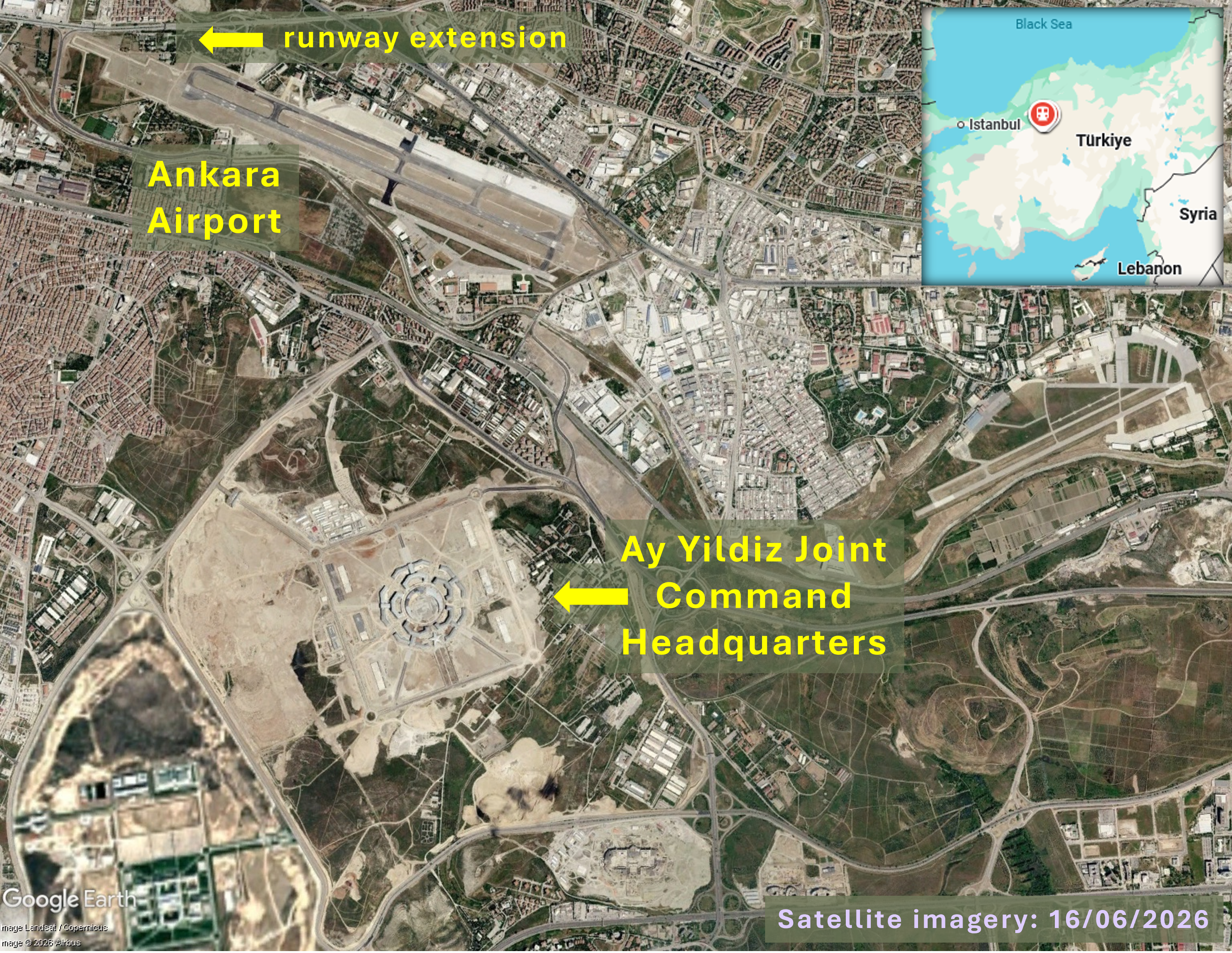
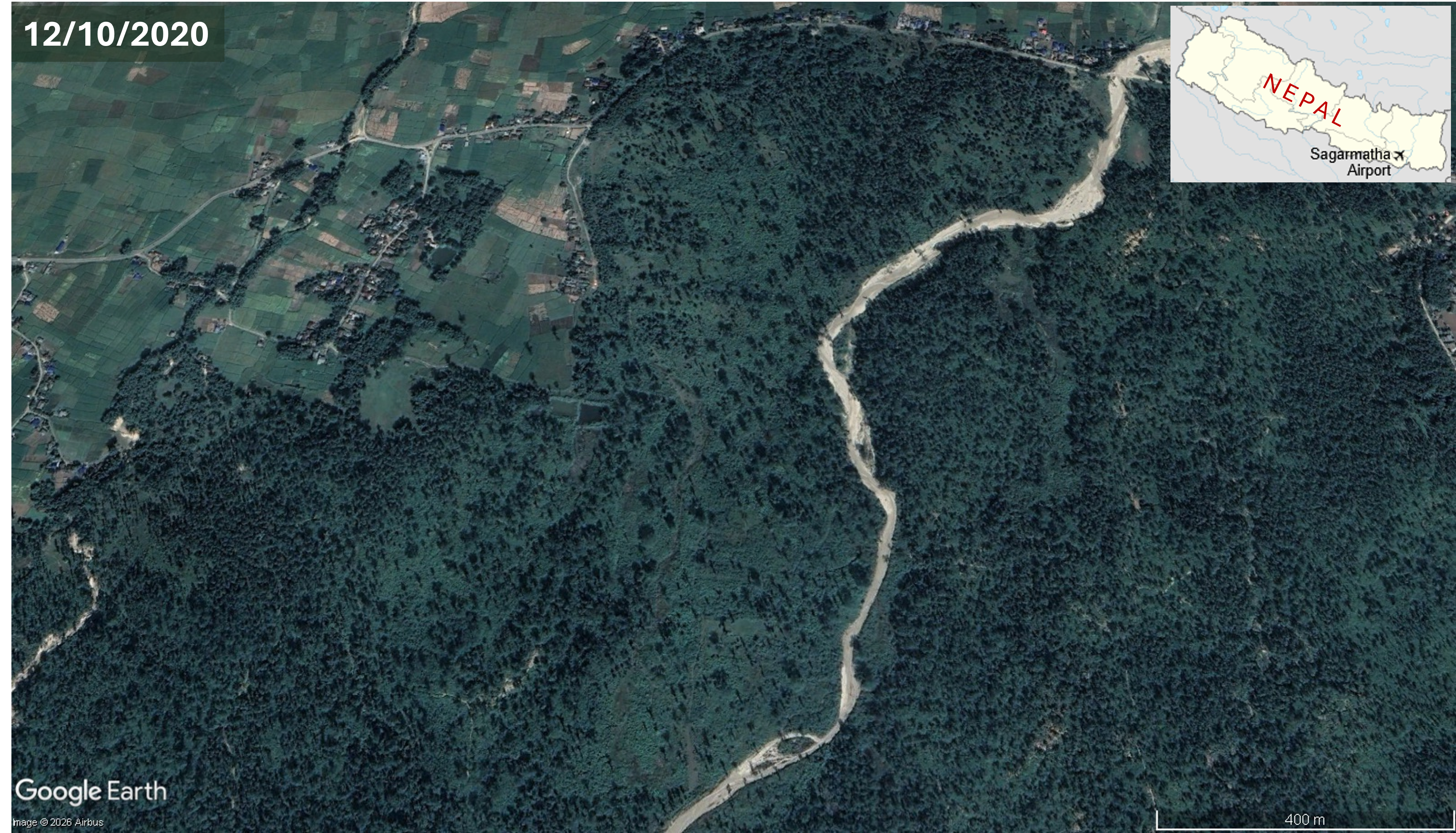
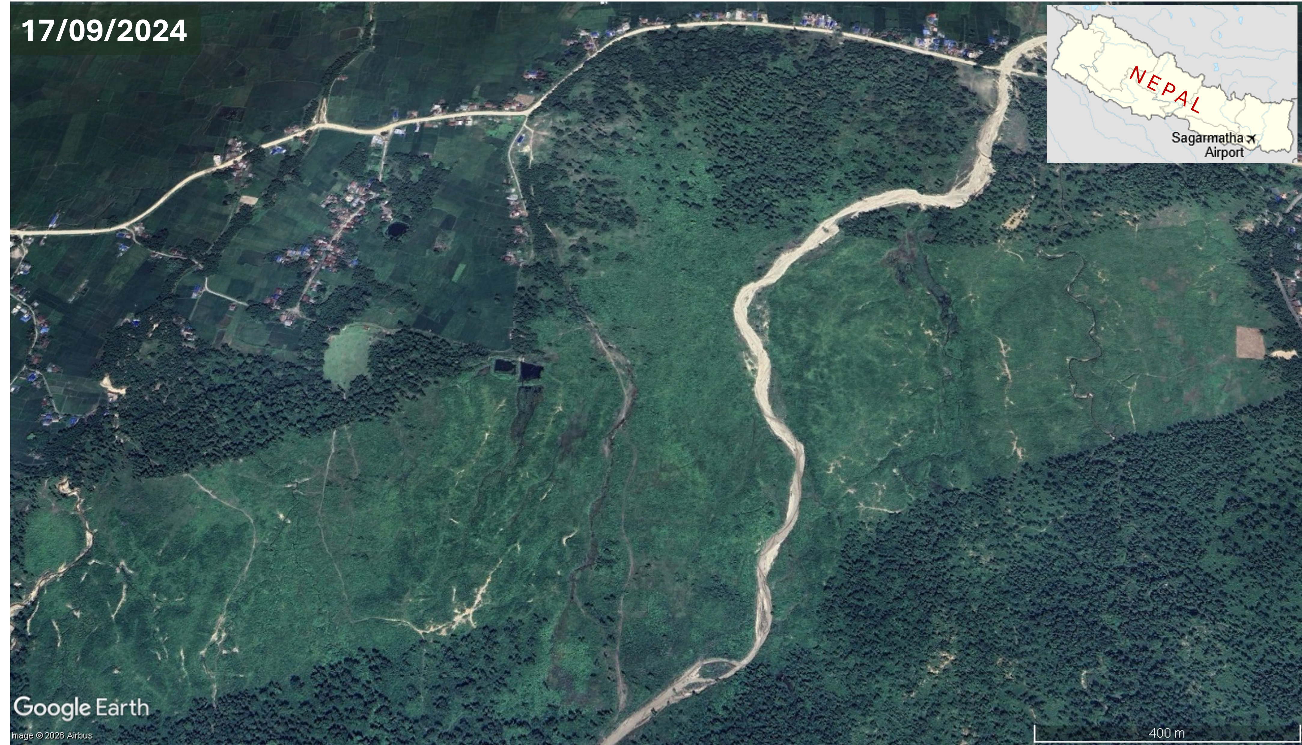


.jpg)