Guwahati Airport and the villages of Azara, Garal and Mirzapur. Satellite imagery: 03/04/2024
A land acquisition notice for a proposed Aerotropolis near Guwahati Airport – the primary airport of northeast India located in the west of Assams’ largest city and also known as Lokpriya Gopinath Bordoloi International Airport (LGBI) – met with anxiety, anger and opposition from many affected residents. Issued on 25th July 2025 by the Kamrup Metropolitan District Administration the notice encompassed 400 bighas (101 hectares) of inhabited and uninhabited land in the villages of Azara, Garal and Mirzapur and impact upon more than a thousand families. Many villagers had given land for construction of Guwahati Airport decades ago and feared loss of their homes and livelihoods. An Azara resident said, “We have already given away vast stretches of land. Now this fresh move will leave many of us homeless.” In Garal village, where the district administration moved to acquire 70 bighas (17.7 hectares) of land for the Aerotropolis project, over 100 pattadars (landholders) were named in the land acquisition notice. Critics of the project claimed the land acquisition process lacked transparency, consultation or a clear plan to rehabilitate affected people and that the main beneficiary would be a private company. Guwahati Airport is owned by Adani, one of India’s largest multinational conglomerates. A local committee member said, “Guwahati Airport is now under Adani’s ownership. So the land being acquired in the name of an airport township will ultimately go to Adani.”
Affected families began to protest the land acquisition process, demanding transparency, a thorough impact assessment and guarantees that they would be rehabilitated. “We are not against development”, said an affected farmer, “But we deserve clarity, transparency and fair compensation. Right now everything feels juggled up and a lot is hidden from the public.” Protests took place in many affected areas. Leader of the Opposition Debabrata Saikia described the move to acquire land for the ‘Aerocity‘ as anti-indigenous and serving corporate interests. He said more than 1,116 families were affected, some of which had held land titles for nearly 200 years. He also warned that, in addition to the families facing displacement, local entrepreneurs in the area running guesthouses and restaurants would be adversely impacted. The location of the project site, near the Deepor Beel freshwater lake, a Ramsar site (designated as of international importance under the Ramsar Convention) raised environmental concerns.
Land acquisition for the aerotropolis had been requested by the managing director of the Assam Industrial Development Corporation (AIDC). Akan Chandra Das, president of Mirzapur Anchalik Bhumi Suraksha Samiti, the committee representing affected residents of Mirzapur, Azara and Garal villages, said, “Already nine to ten times, our families gave land to the government post-independence, for development of the airport, adjacent roads, and defence establishments near the Guwahati airport. If the remaining land is also taken for development projects, where will we go? How will our children survive if they don’t get jobs in other sectors?” Basudev Mali, a retired teacher and owner of 10 bighas (2.53 hectares) of land near the airport, in Mirzapur, said, “If the government continues to take over our lands for airport expansion or for aerotropolis development now, who will ensure the survival of our children? The remaining farmlands were our only hope, but the government wants to take that also.”
A residents’ delegation met with Chief Minister Himanta Biswa Samra, but his attempts to reassure them that only vacant land would be used, for public projects were unsuccessful. Locals remained reluctant to give up their land for either government or private projects. Villagers attending a public meeting in Mirzapur unanimously resolved not to give their land to the government under any circumstances, declaring, “Our land is our identity and livelihood. We will not give it away at any cost.” At the beginning of September 2025 the Guwahati Metropolitan Development Authority (GMDA) suspended building permits and land sales in the proposed aerotropolis area around Guwahati Airport. Additional restrictions were also imposed. The suspension affected Azara, Garal and Mirzapur villages where hundreds of indigenous families were unwilling to vacate their land for the aerotropolis project. They also opposed the notice issued by GMDA as it restricted their rights as landowners.
A plan for a major city extending over up to 600 square kilometres around a new airport in Navi Mumbai diverges from the aerotopolis model of development; the land area and number of villages included in the jurisdiction has reduced.
NAINA (Navi Mumbai Airport Influence Notified Area) originated when the Indian government granted clearance for a second Mumbai airport, in Navi Mumbai. One of the conditions for approval of the new airport was ‘that the Master Plan, Development Plan of Navi Mumbai shall be revised and recast in view of the Airport development and to avoid unplanned haphazard growth around the proposed airport’. Factors considered in assessment of the Influence Zone around the new airport included ‘the requirements of International Airport as per the aerotropolis concept’, connectivity and operation of various planning authorities in the region. Appointment of a ‘Planning Authority for a Planned and orderly development within a radial distance of about 25km from the proposed International Airport site’ was deemed necessary. On 10th January 2013 City and Industrial Development Corporation (CIDCO) was appointed as the Special Planning Authority.
Even at this stage it was evident that NAINA (the pink shaded areas on the map) diverged from the aerotropolis model of development. The designated NAINA area was fragmented and not even contiguous with the Navi Mumbai International Airport site (shown on the map as an orange rectangular area to the west of NAINA). The new jurisdiction, encompassing 270 villages in six talukas in the Raigad and Thane districts, a mix of peri-urban and rural areas, was not the recilinear greenfield site of an archetypal aerotropolis.
A large land area was designated for NAINA, estimated at between 550 and 600 square kilometres (1.5 times larger than the city of Mumbai). Inception of NAINA transferred planning powers to CIDCO; notification specified that all proposals for development permission would henceforth be processed by CIDCO. Land acquisition for the initial phase met with opposition. In 2014, while a survey was being undertaken, residents of the 23 villages notified for development in phase 1 of NAINA (to the east of the Navi Mumbai International Airport site) voiced strong objection saying they were not informed about the project which would adversely affect agriculture, their main source of income.
A spokesperson for the 23 villages said people did not trust CIDCO because farmers who lost their land in the 1970s, for development of Navi Mumbai city, had still not been compensated. Affected families had been promised employment but many were still doing odd jobs to make ends meet. Villagers also raised objections to CIDCO’s practice of providing information in English, a language most of them did not understand. A hearing was rocked by protest and villagers claimed that developers’ land was being treated preferentially, left untouched while theirs was earmarked for public utility purposes.
In an article published in Economic & Political Weekly ‘Fragmentary Planning and Spaced of Opportunity in Peri-urban Mumbai‘ Malini Krishnankutty describes how the Interim Development Plan (IDP) prepared for the first phase of NAINA, encompassing 23 villages, ‘reinforces the planners’ lack of deep engagement with the rural’. NAINA’s role of amassing land for implementation of its master plan exemplified modern urban planning’s disregard for rural areas. Such planning interventions viewed land merely as a resource, the rural as a ‘tabula rasa’ destined for urban development, villages from ‘the narrow perspective of providing very specific social amenities or transport infrastructure’, thus rural villagers and their ways of life were rendered invisible. With regard to NAINA she writes:
‘Once again what is visible here is a superimposition of a vision of a city on these villages, a view of urbanisation that is a foregone conclusion, and a lack of engagement with the future of the villagers, once they are divorced from their lands and livelihoods. There is also no engagement of planners with any idea of conservation, tangible or intangible or of productive farmlands’.
NAINA’s proximity to the Navi Mumbai International Airport site had given impetus to speculative interest in the area. The airport and several major road and rail projects in the pipeline – Mumbai Trans Harbour Link (MTHL), Delhi-Mumbai Insustrial Corridor (DMIC) and a road + rail corridor extending from Virar to Alibaug linking peri-urban regions in the Mumbai Metropolitan Region (MMR) – all require land acquisition by the government that ‘inevitably means dispossession and loss of livelihoods’. In addition these infrastructure projects activate the ‘highway urbanisation’ that is prevalent throught India and the global south. Announcement of new infrastructure triggers commodification of land, opening up rural areas for urban development.
During June, July and August 2015 journalist Rahul Batia travelled along the path of the Virar – Alibaug road and rail corridor running through NAINA, talking with people affected by land acquisition for the project. The route of the road, a transportation corridor 126 kilometres in length and 120 metres wide, stretches from the city of Virar to the north of Navi Mumbai, running southwards through NAINA then curving easwards to the coastal town of Alibaug. On the interim development plan the transportation corridor appeared as ‘a thick white strip snaking through residential areas, growth centres, forests, and urban villages’. Twelve kilometres of the road were within NAINA phase 1 and impacts upon the 23 villages within this area loomed.
NAINA map showing route of road through Nere and other villages. Source: cidco naina
The poorest locals were the most perturbed by the ‘corridor of uncertainty’, believing it would ‘hit them hardest’; some were convinced that they had been ‘singled out for some kind of punishment’. There were allegations that the route being marked out for the road curved to avoid homes and land owned by rich and influential residents. Adivasis at a hamlet in Nere, one of the affected villages, came across a mark painted into an approach road and thought it was connected with the new transport corridor. The sarpanch (head of village) of Nere knew little about the road except that people would be relocated to make way for it, and did not know where they would go to. He had not seen the map of NAINA. Pointing out a notice with a yellow diagonal stripe marked ‘CH 51554’ he said, “They came here, made markings, and left. Nobody told us anything.” Inhabitants of the 23 villages in the first phase of NAINA lived in uneasy uncertainty. NAINA officials were holding consultations but many affected residents complained of a ‘disconcerting lack of information available about exactly what shape NAINA will take’ and said that rates for people wanting to build on their land were ‘exhorbitant’.
Opposition to land-pooling scheme
Unrest over NAINA plans continued into in 2016. In February farmers of 111 villages opposing NAINA united to form a committee, Shektari Utkarsh Samiti, and marched from Khargar to Panvel. They voiced many demands for changes to NAINA policy, including that the amount of their land to be given to CIDCO under the land pooling scheme, whereby groups of land owners hand over their land to a government agency for development of infrastructure, with a proportion of the land being returned to the landowners, be decreased from 40 per cent to 30 per cent. In September representatives of 36 villages in the Panvel taluka (administrative district) immediately to the east of the Navi Mumbai International Airport site, said they did not want to be part of NAINA and wished to be excluded from the plans and instead be included in the Panvel municipality. Together these villages cover 69.6 square kilometres, a substantial proportion of the total NAINA area.
Rajendra Patil, a representative of one of the villages, Kolkhe, said that waiting for finalization of NAINA plans had stalled development in their villages, and that the development model was tilted in favour of big developers whilst working against the interests of local farmers. Anesh Dawale, a former head of Shivkar village, said of NAINA’s land pooling scheme: “It is just a garb to release farm lands held by villagers to the builder lobby”. In particular, local people were of the view that the minimum land pooling norm of 18 acres favoured construction magnates. Dawale also said that the curbing of village council powers under NAINA had a negative impact on civic services, a view shared by Panvel’s MLA (Member of Legislative Assembly), Prashant Thakur.
In December 2016 it was reported that 14 villages on the outskirts of Navi Mumbai and included in NAINA feared losing their land due to the project. Community representatives said that authorities were reserving plots of land without consulting local people and that inclusion in NAINA was blocking development in their villages, in contrast with surrounding areas that were flourishing. The 14 villages repeated demands first made in July 2015 to be merged with the civic body NMMC (Navi Mumbai Municipal Corporation) instead.
NAINA area reduced
NAINA was described as ‘potentially the biggest smart city in India‘ at approximately 600 square kilometres in November 2014 but by May 2016 CIDCO appeared to favour polycentric urbanisation, in the form of ‘30 smart cities‘, Special Economic Zones and growth centres. CIDCO officials estimated that, in its initial years of operation, the new airport would handle two to three million passengers, a fraction of the widely publicised projection of 20 million passengers per year in the first phase, rising to 90 million when expanded to full capacity. By July 2017 many parcels of land in the 1st phase of NAINA had not been acquired due to opposition from villagers. The state urban development department had approved development of the 23 villages three months previously but the development plan was still not publicly available.
Map of NAINA, reduced to 474 sq km, September 2017. Source: CIDCO
CIDCO’s Modified Draft Development Plan for NAINA, published in September 2017, anticipates an inflow of passengers from the new airport, but there is no mention of mulitiple millions of passengers annually. The plan does not include the aviation-dependent tourism or freight facilities that form the mainstay of an aerotropolis. The plan details a substantial reduction in NAINA’s footprint and a map shows further fragmentation of the designated areas. Several villages were transferred to other jurisdictions, becoming part of Maharashtra State Road Development Corporation Limited (MSRDC – a development plan for the area along the Mumbai-Pune Expressway), Matheran Eco-Sensitive zone (MESC) and Maharashtra Industrial Development Corporation (MIDC). Thus the number of villages incorporated in the NAINA plan decreased to 224 and the land area was reduced to 474 square kilometres.
The voluntary land-pooling scheme was causing delays, so, in April 2018, at the request of CIDCO, the state government moved to fast-track the NAINA project by way of invoking town planning scheme (TPS) provisions for compulsory participation of villagers residing in areas encompassed in the development plan. Participation in the project was made compulsory for the 23 villages in Phase 1 of NAINA. A draft plan for this 37 square kilometre pilot area was published, giving villagers just 30 days to make suggestions and objections, enabling CIDCO tosanction the scheme in three months. CIDCO also moved to expedite road building, using a fast-track TPS process, allowing a total of 21 months from announcement to execution.
Diverting water to NAINA
NAINA will take up water as well as land. CIDCO’s September 2017 Modified Draft Development Plan for NAINA calculates NAINA phase 1 water demands to be 8.33 MLD (millions of litres per day) in 2021, rising to 29.75 MLD by 2031 then reaching 45.07 MLD by 2041. New sources of water are anticipated to meet the increasing demands of NAINA and other CIDCO projects: the Balganga dam from which 150 MLD would be available for NAINA and Khopta Area (another CIDCO project) and the proposed Kondhane dam from which CIDCO expects to receive 250 MLD. The state transferred the Kondhane dam project from the water resources department to CIDCO in August 2017. The dam will draw water from the Ulhas river.
Shortage of water supplies is a perennial problem in many areas of Mumbai. In 2018 water scarcity was exacerbated by construction activity for Navi Mumbai Airport, which put pressure on water supplies impacting on surrounding communities, including those within NAINA. By May 2018 Panvel had been suffering a severe water crisis for three months. Every summer water scarcity forced residents to rely on water tankers. But in 2018 the situation was more serious. Many areas in Panvel were only receiving water on alternate days. Villages under NAINA were only getting water every three or four days. A resident of Khanda colony, Vishnu Gavali, filed a public interest litigation (PIL) requesting the court to direct civic authorities to resolve the issue. The PIL states that, under the constitution, all citizens have the right to food, water and a decent environment, and that CIDCO was failing in its duty to provide basic amenities. Gavali said “As airport work has started, a lot of water is being used for the construction activities but sadly, the locals have been neglected.” A resident of Roadpali said “Cidco has given permissions for so many upcoming projects in the city, I don’t understand how they would fulfill water needs of so many projects.”
In March 2019 residents of Panvel gathered near the CIDCO water tank premises in protest over poor and erratic water supplies, denying their fundamental rights to a basic amenity. Leader of the delegation, Apoorva Prabhu, said they had suffered water scarcity for six months and were requesting regular water supplies of least two hours daily. In September 2019, with many areas facing water shortages, CIDCO took measures to ensure that NAINA would not be affected by the water crisis. A detailed project report (DPR) on Kondhane dam, to help ensure adequate water for NAINA, was expected to be completed within a year and revive the project.
Objections to NAINA plans
On 28th June 2019 the Times of India reported that the urban development department would publish the final approved plans for NAINA and Maharashtra State Road Development Corporation Limited MSRDC after the monsoon season. Citizens demanded the government publish the report of the planning committee on the objections and suggestions made by the public in order for there to be transparency over whether or not these concerns raised were addressed or not. Pankaj Joshi, architect and executive director of the Urban Design Institute said “Objections were raised to the government proposing industries in green zones in the metropolitan regional plan. The entire green belt will become brown if it is approved.”
Map of NAINA September 2019, area shrunk to 371 sq km. Source: Times of India
By September 2019 NAINA, promoted as India’s largest planned city in 2014, had shrunk to just over half its original size. The plan for a new city, spread over up to 600 square kilometres of land, had shrunk substantially, now occupying a 371 square kilometre plot. The map indicated further fragmentation of the NAINA area and the number of villages incorporated in the plan had reduced from 270 to 175. The most recent government notification granted sanction for the development plan for the remaining 152 villages covering 334 square kilometres, along with the 23 villages included in the 37 square kilometres allocated for phase 1.
Unrest among farmers affected by land acquisition for NAINA was reported again in January 2020. A protest against CIDCO had already taken place and farmers were planning further agitation. Several local leaders were raising their voices against the scheme. By 17th March CIDCO was reportedly ‘going ahead aggressively’ with implementation of NAINA, in the face of unrest by impacted people. About 10,000 farmers from the 23 villages of the first phase of NAINA were planning a demonstration. The farmers alleged that the town planning scheme was not beneficial to them and demanded a review. Vaman Shelke of NAINA Prakalpbadhit Shetkari Utkarsh Committee (NPSUC) said they were given notice if carrying out any construction work on their land, leaving them with no option but to accept the scheme. “This is a participatory scheme and we cannot be forced to join” said Shelke, explaining that farmers were demanding return of 50 per cent of developed land under the land pooling scheme instead of 40 per cent, along with additional benefits for loss of their agricultural land.
3,500 families struggle for fair rehabilitation for displacement to make way for Navi Mumbai International Airport. Mangroves and other bird habitats will be lost and pre-construction blasting work has damaged houses and caused injuries.
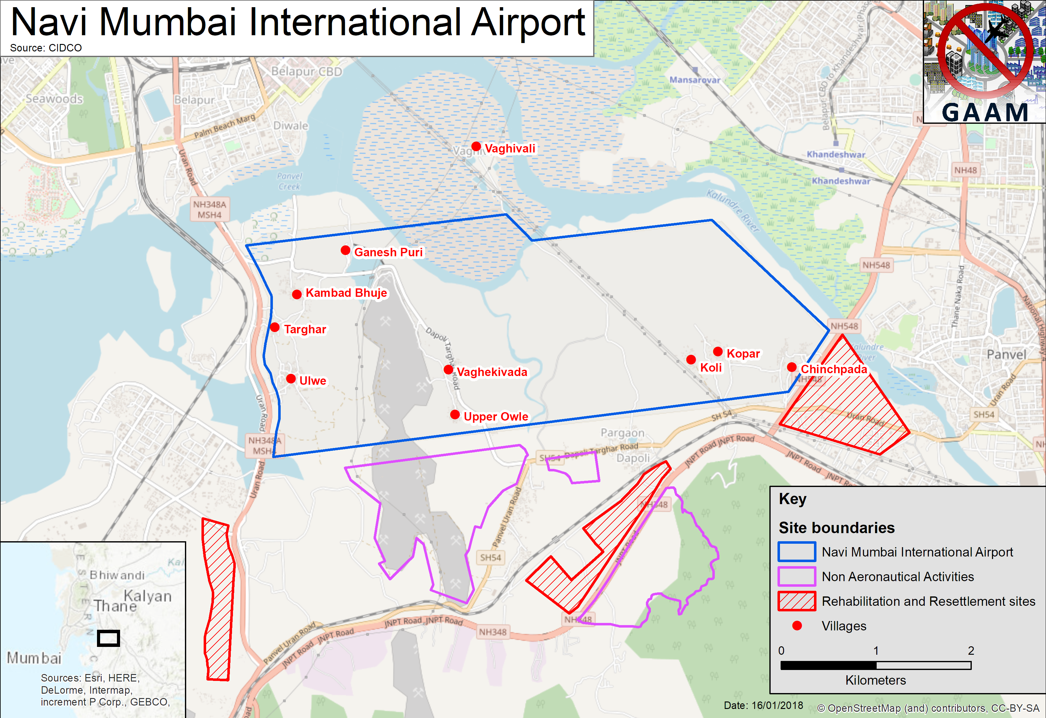
Approximately 3,500 families residing in 10 villages face displacement from their homes and land for a new airport in Navi Mumbai, in the Kovar-Panvel area 40 kilometres to the east of Mumbai on India’s west coast. First proposed in 1997 and approved by the government in 2007, the response of affected people, resisting land acquisition and demanding improved rehabilitation assistance, is just one of many factors that stalled the Navi Mumbai International Airport project. The inevitability of environmental damage led to delays in being granted government clearances. Biodiverse wildlife habitats encompassed within the site will be destroyed: 121 hectares of forest, 162 hectares of mangroves and 404 hectares of mudflats. Environmental groups have long criticized the airport site selection, saying that the government refused to consider possible alternatives. Waterlogged and low-lying, the site will need to be raised from 2 metres to 5 metres above sea level, posing construction challenges.
A mega-airport is planned, handling 10 million passengers annually upon completion of the first phase, rising to 60 million passengers per year upon commencement of full commercial operations with two parallel runways, which is scheduled for 2030. If this traffic projection proves accurate Navi Mumbai will be India’s busiest airport. The airport core area, allocated for aeronautical activities, is 1,160 hectares of land. In addition to the core airport site, three areas have been earmarked for non-aeronautical activities (airport-linked commercial development such as hotels and retail), taking the total airport area to 2,268 hectares. Three plots of land have been allocated for rehabilitation and resettlement for the affected villagers.
Levelling the site and diverting rivers
Villagers have not yet relocated to the resettlement areas. Yet, in October 2017, as they remain in their homes, massive earthworks preparing the site for construction of the airport began, a work programme that is expected to take between 18 and 24 months. The course of Ulwe river which runs north-south through the site is to be re-routed by 90° and the Ghadi river running alongside the northern boundary is also being re-channelled. Hills are being blasted away with explosives to make way for the airport runway, the soil and stones being utilized for filling in and levelling the site. The height of Ulwe hill, the largest hill on the site, is being reduced from 90 metres to 10 metres. Vast volumes of loose earth and stones will then have to be compacted down to make it stable enough to withstand airport operations.
Difficult terrain brings serious construction difficulties. The land is swampy and flood-prone, large areas are frequently waterlogged, especially during the monsoon season. “Even from a simple engineering point of view, building an airstrip on reclaimed land, mudflats and mangroves – it is going to be very unstable,” predicted Debi Goenka, executive trustee of the Conservation Action Trust. As of December 2017 most of the site was underwater. Critics of the airport project also point out the high level of state expenditure on pre-construction earthworks that are necessary to make the fragile coastal zone sufficiently resilient to withstand the new airport, an estimated ₹2,345 crore (US$370 million).
CIDCO (City and Industrial Development Corporation), a city planning agency formed by the Maharashtra state government, is responsible for implementing the airport project. GVK, an Indian conglomerate with interests in energy, resources, transport and other sectors, has been awarded the contract to build and operate the airport. By May 2018, CIDCO expects to hand the project over to GVK for completion of pre-construction groundwork on the airport site before the building phase begins. Predictions of project cost escalation have proved well founded. By 2017 CIDCO’s cost estimate for the project had more than tripled, escalating from US$753 million to US$2.5 billion.
As earthworks In November 2017 two thousand residents of the villages of Targhar, Pargaon, Ulwe, Kolhi, Kopar, Ganesh Puri, Chinchpada, Dungi and Manghar gathered to step up their demands for fair compensation and rehabilitation from CIDCO for vacating their land and homes to make way for the airport project. The villagers discussed many concerns including unnecessary land acquisition and united their struggles to form a new organization: Navi Mumbai International Airport Affected Peoples, which will take up their demands with CIDCO.
The villagers’ meeting followed a major protest by residents of six villages on 12th October, which brought pre-construction work on the airport site to a halt. An article on the mid-day.com news website stated that 5,000 people attended the protest. Only 10 per cent of the affected families had vacated their homes, over 3,200 families were still living on the site and they resolved to remain in their homes until the plots of land allocated for resettlement were developed. On 27th October it was announced that, following a meeting between CIDCO officials and affected residents, attended by 500 people and with a heavy police presence, work on the Navi Mumbai Airport site would resume under heavy police protection. CIDCO reported that four platoons of state reserve police had been made available.
Blasting damages houses, injures workers and villagers
The state is protecting the airport from people with legitimate grievances, but failing to protect people from construction of the airport. Blasting work caused residents to complain about tremors affecting their houses and has caused injuries. At the time of the October 2017 protest explosives were being set off three times per day, loosening the ground in order to cut and level Ulwe hill to make way for the airport runway. Taking place at a distance as little as 100 metres from people’s homes blasting sent stones flying distances of up to 200 metres, including into a nearby school. Vibrations from the blasting had caused cracks in the walls of houses in the village of Ulwe, making some people afraid that their houses might collapse.
On 6th January 2018 five engineers working in the site were injured, two of them severely, by supposedly ‘controlled’ blasting work that was underway 300 metres away from them. Explosions had triggered a landslide and the workers were hit by falling rocks. Villagers in Siddhart Nagar which is situated at the foot of Ulwe hill suffered injuries too; five women were bruised by stones coming through their roofs and a seven-year old boy who had been playing outside his house needed two stitches to his head. Affected residents, who had argued that blasting should not commence until they are rehabilitated, organized a protest march opposing blasting on the airport site and called for an atrocity case to be registered against CIDCO and GVK. Two days after the landslide, as GVK signed the concession agreement with CIDCO, the men of the village stalled work at the blasting site while the women made an unsuccessful attempt to meet with CIDCO officials at their offices. The father of the boy injured in the landslide, said “My wife and a few other women went to meet CIDCO officials, but they were not entertained. Why is it difficult to rehabilitate us when crores are being spent on the project?”
After the blasting injuries CIDCO officials ordered Siddhart Nagar residents to vacate their homes to get them out of the way while blasting work takes place, for two hours every day 1-2pm and 5-6pm. Villagers voiced strong objections to this disruption of their daily lives and being forced to stand in scorching sun. CIDCO’s lame excuse for undertaking the dangerous blasting work with people still in the vicinity is a claim that Siddhart Nagar villagers have not been rehabilitated because more than half of of the households were established after the 2013 cut-off date for eligibility. A representative of the villagers insists this is not the case and that they have documents proving their residency in the area for the past seven to eight years.
Residents’ long struggle for fair rehabilitation
Residents being displaced for Navi Mumbai Airport, facing loss of their homes, communities, land and livelihoods, have sustained a long-term struggle for fair rehabilitation. Back in 2010 a public hearing was boycotted by residents of all 18 affected villages standing to lose their land. Approval of the airport project appeared to be a foregone conclusion; journalist Nidhi Jamwal wrote that the hearing was ‘wrapped up in hour’, with the few journalists that attended having been told by their employers that negative stories would not be published. There was not much to report anyway as a recently completed Environmental Impact Assessment (EIA) and a study on the diversion and channeling of rivers were not made public. People from the affected villages stood outside the meeting waving black flags in protest, demanding due compensation.
Villagers being displaced for the airport, referred to as project affected persons (PAPs), are dissatisfied with the rehabilitation and resettlement areas and say that the offers of land and cash sums to build new houses in these designated areas are in sufficient to compensate for what they will lose. PAPS are being offered construction aid to build their new houses, but say that the amount, calculated in 2011, is low. Their request that construction aid be increased to reflect current costs seems particularly reasonable in the light of CIDCO’s repeated upward revision of airport construction costs.
At the time of the 12th October 2017 protest, which was precipitated by apprehensions over CIDCO’s looming 17th October deadline for villagers to vacate their homes, Nata Pratil, president of the committee of MLAs (Members of the Legislative Assembly) which is demanding justice for the 3,500 families facing displacement, said that the deal offered to villagers to give up their land was altered after they had agreed to it, the allocation of space for a new house being reduced. CIDCO claimed that the plots for displaced families were ready, but PAP representatives disputed this, saying that schools, utilities, streetlights, roads and a crematorium had yet to be developed. And PAPs said nothing had been done to make provision for replacing temples that will be lost to the airport. CIDCO had committed to allocation of plots of land suitable for relocation of ten old temples, along with compensation for rebuilding. In November 2017 some PAPs alleged that records proving their land ownership had been destroyed by CIDCO.
Loss of mangroves and the risk of bird-strikes
A significant regulatory hurdle to building Navi Mumbai airport, pertaining to the mangrove forest in the airport site, was removed in 2009. Coastal Regulation Zone notification, ensuring tight controls over construction, was amended in order to allow conversion of mangrove forest to an airport. Replacing mangroves with the impermeable concrete and tarmac of an airport will disrupt the water balance in the wider region. Mangroves are a natural buffer between land and sea, the interwoven roots preventing coastal erosion, absorbing rainfall and tidal surges. Excess water has to go somewhere and removal of mangroves for the airport could make the surrounding area more susceptible to flooding.
CIDCO’s suggestion of compensatory plantation to make up for loss of mangroves, about 200 kilometres distance from the airport site in Dahuna, met with criticism that these complex, locale-specific ecosystems, richly biodiverse and taking time to evolve, cannot be created instantly. CIDCO then suggested a mangrove sanctuary close to the airport site, commissioning a study of wetland bird habitats that was conducted by Bombay Natural History Society (BNHS). The study highlighted the conflict between airport operatiosn and birds. Dr. Deepak Apte, director of BNHS cautioned that “A mangrove park within the perimeter of aircraft takeoff and landing zones can be an extremely serious aviation hazard”. Mangroves are an attractive habitat for many bird species, so a mangrove sanctuary poses a risk of bird strikes, collisions with aircraft that can cause fatal accidents.
In 2015 the Ministry of Environment, Forest and Climate Change National Board for Wildlife withdrew the requirement for a mangrove sanctuary as part of the project. The developer will be required to make the area designated for the mangrove sanctuary unattractive to birds to reduce the risk of bird strikes. An environmentalist from Vanashakti, an NGO focused on forest, mangrove and wetland protection, questioned the sincerity of CIDCO’s promise of a mangrove sanctuary, wondering if it was known to be unfeasible due to the bird strike risk, and merely a ruse to help get clearance for the project.
Airport operations are likely to impinge upon birds habitats beyond the site – coastline, creeks, mangroves and inland wetlands. A survey conducted BNHS showed an estimated 266 bird species living within a 10 kilometre radius of the airport site, including the Karnala Bird Sanctuary. Aviation experts advised that a plan for a bird sanctuary to protect migratory flamingos, in the Panju-Funde wetlands, 20 kilometres from the airport site, would be under the take-off and landing flight paths and a bird strike disaster waiting to happen. Large birds such as flamingos pose the most significant bird strike risk. Debi Goenka criticized the airport authorities’ opposition to the Panju-Funde bird sanctuary: “In the name of development, we cannot simply kill all the beautiful birds and destroy their wetlands’ habitat. They could have easily shifted the proposed airport to some other place 10 years ago”
Interlinked megaprojects and car dependency
Construction of another megaproject, the Mumbai Trans-Harbour Link (MTHL), the longest bridge in India – is to be speeded up, for completion in time for it to be linked with Navi Mumbai Airport. Stretching across Mumbai Bay, six lanes wide and 22 kilometres in length, the new bridge will link the mainland with Sewri on the eastern edge of South Mumbai. Like the airport, the bridge is set to destroy birdlife habitats. First mooted in the 1970s it met with opposition because of the impact on Sewri mudflats, an area containing mangroves and providing an important feeding ground for the thousands of flamingos flocking there every winter. MTHL’s starting point in Sewri, extending along 5 kilometres of coastline, poses a threat to an estimated 20,000 – 30,000 flamingos and 38 hectares of formerly protected mangroves will be lost, along with 8.8 hectares of protected forest at the Navi-Mumbai end.
The shoreline sections of MTHL will impact on people as well as the environment. A 2016 assessment survey revealed that the homes of 229 families, 53 business premises and 10 commercial structures in Sewri will be demolished to make way for MTHL and an official outlined a plan to resettle then in Bhakti Park, Wadala, in southern Mumbai. Artisanal fisherfolk from nine villages whose livelihoods are impacted by MTHL will receive a one-time compensation fee. As of July 2017 over 3,000 compensation claims had been submitted and the Mumbai Metropolitan Development Authority (MMRDA) was about to begin sifting through the applications to identify ‘genuine claimants’. The cost of the MTHL bridge is comparable to Navi Mumbai International Airport at US$2.6 billion. Since 2005 when bids for the MTHL were first invited the cost has escalated significantly, by 350 per cent, due to delays, rising input costs, mandatory environmental and rehabilitation and design changes. Citizens will foot the bill directly through tolls and indirectly through various taxes.
A 5.8 kilometre coastal road connecting the MTHL bridge with Navi Mumbai International Airport is a megaproject in its own right; large stretches of the road will be elevated with a 1.76 kilometre section over mangroves to be built on stilts. The coastal road is just one of a proliferation of road infrastructure projects enabling traffic growth to support the new airport: new roads, widening of existing roads up to 8 and 10 lanes, loop roads and interchanges. Journalist Sanjay Banerjee envisages these ‘speed corridors’, described by CIDCO as enabling “smooth and seamless vehicular movements”, having an ‘octopus-like grip‘ across Mumbai. The airport-centric road building programme is designing in a high level of dependence on cars, it is based on a projection that 85% of air travellers will use private vehicles.


 A mega-airport is planned, handling 10 million passengers annually upon completion of the first phase, rising to