In the early days of the Covid-19 pandemic, on 15th April 2020, officials from the Indonesian government and the East Java province attended a virtual groundbreaking ceremony for a new airport in the Kediri regency. The event marked the official start of construction works that had actually begun three months earlier in January when heavy machines were levelling soil, following several delays that were partly caused by some affected residents refusing to release their land for the project due to unpaid compensation. Fewer than 20 families, in the villages of Bedreck and Bulusari, remained in the area. A villager told The Jakarta Post “If we accept the price, we won’t be able to buy land and build a house of similar value to what we have now”. She said none of the villagers wished to hamper development of the airport, they simply wanted fair compensation. The Kediri administration said that only 0.6 per cent of the 400 hectares of land required to build the airport had not been acquired.
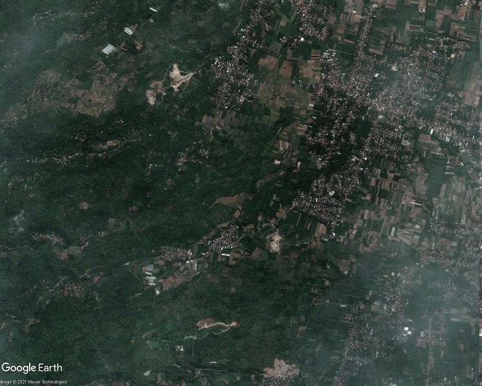
Kediri Airport site area, April 2018
Kediri Airport site area, satellite imagery, June 2020
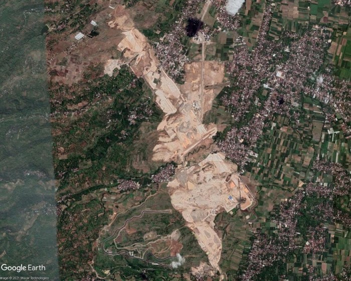
Kediri Airport site area, satellite imagery, November 2020
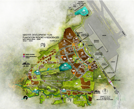
The Kediri Airport project (also referred to as Dhoho Airport) was approved in 2018. The first of the satellite images above shows the airport site area in April 2018, consisting of villages and farmland. The second image shows the same area in June 2020 after earthworks had levelled large areas of land. The third satellite image is from November 2020, by which time earthworks had progressed and impacted upon a larger area, transforming the landscape from verdant green to a pale expanse of crushed and compacted rock. Adjoining this area, extending to the southwest, additional earthworks and construction of roads can be seen. This airport-adjacent development is shown in the fourth and final image in the slideshow, a graphic of the Kediri Master Plan visualising a future tourism and residential complex in this area. Produced by ARKDESIGN Architects and Planners, the ‘MASTER DEVELOPMENT PLAN, PLANTATION RESORT & RESIDENCES’ shows two commercial development areas, a warehouse, utility complex and parking adjoining the airport terminal and cargo buildings. Extending to the southwest is an area allocated for hotels, residences and various tourism facilities including five lakes. Progress of construction of the one of these artificial lakes, near the centre of the planned development, can be seen in the satellite images. The graphic indicates proximity to Mount Wilis, a solitary volcanic massif amidst the surrounding low-lying plains. The route of a future toll road is shown extending from the southeast of the project site, between the airport and the adjacent development.
Controversy over land acquisition for Kediri Airport dates back to 2017, when residents, aware of large-scale land acquisition, questioned whether it was a government or private project. In March 2019 residents of one of the affected villages, Jatirejo, hung dozens of banners along village roads, stating their refusal to accept the prices offered by land buyers for agricultural land, that they said were too low. In October 2019 37 head of family residents of Bedrek Selatan hamlet, Grogol village, had not released their land for the airport project as they had not agreed compensation. The airport plan had caused the price of land around the project site to soar. Land prices had also gone up in Bulusari village where some residents were confused over where to relocate to. Some who had received compensation were experiencing difficulties in finding places to relocate to because of soaring land prices. A shift in the location of the airport runway had required acquisition of additional land, leaving residents with difficulties finding land to relocate to. In January 2020 45 residents of Grogol village rejected land acquisition, protesting over a drop in the compensation offer that would only be sufficient for them to buy land in far away suburbs. Residents’ coordinator said they were being pressured to give up their land for the airport. In February 2020, just two months before the groundbreaking ceremony, some residents had still not agreed to the compensation offers for land acquisition. Ten families were refusing eviction because, while the price of land in their village had dropped drastically, the price of land in new locations where they might settle had risen; they faced the prospect of a huge loss. A resident of Bedrek spoke of repeated visits by land buyers over several months and being pressured to accept the price offered for land.
At the time of writing some residents are still unwilling to leave their homes and suffer the impacts of airport construction works. Several villages – Tarokan, Tiron, Bangkan, Jatirejo and Grogol – have been demolished for the airport project and most of the inhabitants had left. Tugiyem, one of few villagers remaining in Mbandrek Selatan, spoke in the midst of swirling dust and roaring engines of construction vehicles, staring at a pile of dredged rocks. She had lived there since the 1960s and used to work gazing livestock, but her animals were left dying as the construction company had fenced off the land and she could not reach them. A metal fence erected on one side of Grogol, ostensibly to deter trespassing and reduce pollution from construction works, limits residents’ access to their village. One of the main roads connecting Grogol village has been blocked off to aid construction works. This had forced farmers taking their crops to the city to take longer routes and food stalls and shops near the road had to shut down. Within a month of closing access to the road four shops had gone bankrupt. Owners of surviving shops have to rely on custom from their neighbours, including Siti Anggirawan who was forced to close her textile shop. Waiting for customers outside her grocery store, Sri Katun said air quality in Grogol had deteriorated, “When a strong wind blows, construction dust drifts into the house. I often cough.” But she had no thoughts of giving up the land she had bought after years of saving up money, saying, “This house is witness to my ups and downs alongside my husband. We want to die on this land that has been part of our history.”
Earthworks for the airport project consisted of a cut and fill excavation up to 35 metres high. Rivers are being diverted away from the runway via two enormous box culverts, one 570 metres in length and the other 470 metres, made from reinforced concrete. A 3,300 metre runway is being built, to acommodate the largest world’s largest aircraft such as the Boeing 777 and Airbus A350. Construction of the airport proceeds even though plummetting air traffic since the start of the Covid-19 pandemic casts doubts on the feasibility of traffic predictions. And the projections for Kediri Airport, as reported in ACI World Airport Development News, Issue 4 2020, are ambitious. Upon completion of the first phase of construction, scheduled for April 2022, Kediri Airport is projected to handle 1.5 million passengers per annum, eventually rising to more than 10 million annually. A Transport Ministry offical said Kediri Airport would serve domestic flights for tourism, and might also be used for cargo related to possible future agricultural and industrial activity in East Java. Kediri Airport is the first in Indonesia to be fully funded by the private sector. Tobacco company Gudang Garam will spend up to USD732 million to acquire 457 hectares of land and a subsidiary, Surya Dhoho Investama, will oversee development of the airport.
A new interactive map documents cases of airport-related injustice and resistance around the world. All across the globe airport projects are generating serious conflicts and social and environmental impacts: land acquisition, displacement of people, destruction of ecosystems, local pollution and health issues. A new map based on scientific research presents 80 cases as detailed examples of the conflicts generated by airport projects around the world. The research also identified more than 300 cases of airport projects where there is evidence of conflict, that merit further investigation. Research began in 2018 and has been jointly conducted by the EnvJustice project of the Environmental Science and Technology Institute at the Autonomous University of Barcelona (ICTA-UAB) and the Stay Grounded network.
In many countries, airport planning, construction and expansion continues, in spite of the steep decline in air traffic since the beginning of the Covid-19 pandemic. All aviation expansion, wherever it takes place, contributes to the global problem of climate destruction. Aviation, being fossil fuel dependent and intensive, is a major and growing source of greenhouse gas emissions. By documenting a multitude of local struggles against airport projects the Map of Airport-related Injustice and Resistance contributes to a broad and diverse global movement for degrowth of aviation and transition to a just and sustainable mobility system.
“Communities around the world struggle against eviction from their homes and farmland for aviation expansion, and to protect forests, wetlands and coastal ecosystems, our research shows. Our interactive feature map, the first of its kind, documents a multitude of airport-related injustices and inspirational resistance movements,” say Sara Mingorría of EnvJustice (ICTA-UAB) and Rose Bridger of Stay Grounded.
Many of the cases documented and analysed involve affected communities opposing land acquisition for airport projects. In about half of those cases studied there were problems of land dispossession (50%) and displacement (47%). Many communities resisting displacement have suffered human rights violations and state repression: forced evictions, harassment, intimidation, arrests, imprisonment and violence. In around a third of the cases studied there were problems of repression (30%), militarization (29%) and the conflicts reached a high level of intensity (35.5%).
Site clearance for many airport projects also obliterates wildlife habitats and biodiversity. In 48 percent of the cases analyzed, problems of loss of landscape were registered, 41 percent involved deforestation impacts and 32 percent loss of biodiversity.
The Map of Airport-Related Injustice and Resistance is a joint project by the EnvJustice (ICTA-UAB) and Stay Grounded. Information has been contributed by organizations, journalists, activists and academics. The research project is co-founded and coordinated by Rose Bridger (Stay Grounded/Global Anti-Aerotropolis Movement-GAAM/EnvJustice ICTA-UAB) and Sara Mingorría (Stay Grounded/EnvJustice ICTA-UAB); Yannick Deniau (Envjustice/GeoComunes) and Mira Kapfinger (Stay Grounded) joined the coordination team during the project. The 80 published cases are just the beginning of the mapping project. The research team anticipates that many more conflicts will be documented on the map as the project continues.
EJAtlas is an online database and interactive map documenting and cataloguing environmental conflict around the world. It started in 2011 and counted on the collaboration of hundreds of researchers and organizations. It is now coordinated by the ENVJUSTICE project at ICTA-UAB.
Stay Groundedis a network of more than 160 member organisations from all over the world, among them: NGOs, climate justice groups, indigenous organisations, labour unions and civil initiatives against airport noise and expansion. Together, they fight for climate justice and a fair reduction of aviation.
See the airport injustice cases on the Feature map
The first section of a two-part video, Aerotropolis: Evictions, Ecocide and Loss of Farmland, highlights damaging impacts of aerotropolis (airport city) projects on people and the environment. Allocation of large sites means that communities face displacement and entire ecosystems can be destroyed.
The video looks at 14 aerotropolis-type projects: New Yogyakarta International Airport, Kertajati Airport and Aerocity, Kualanamu Aerotropolis (Indonesia), 2nd Jeju Airport (South Korea), New Phnom Penh Airport (Cambodia), Long Thanh Aerotropolis (Vietnam), Taoyuan Aerotropolis (Taiwan), KXP AirportCity (Malaysia), Andal Aerotropolis, Bhogapuram Airport and Aerocity, Shivdaspura Aerocity (India), Anambra Airport City (Nigeria), Tamale Airport (Ghana) and Western Sydney Aerotropolis (Australia). For further information see the comprehensive Reference list of source material, including photos and other images.
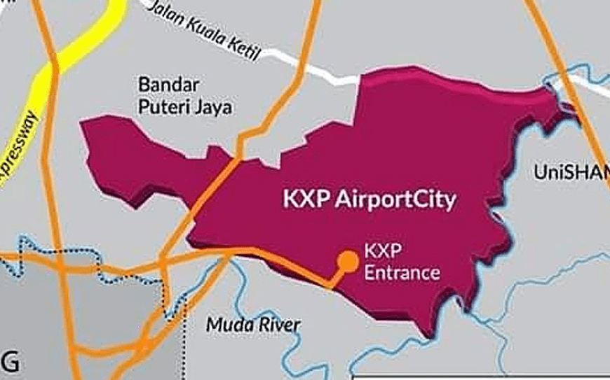
A proposed aerotropolis in Malaysia, KXP AirportCity, is one of a number of strategic infrastructure projects under the Northern Corridor Economic Region (NCER) Strategic Development Plan 2021-2025. The project, also referred to as Kedah Aerotropolis, comprises a new airport, Kulim International Airport and Sidam Logistics, Aerospace and Manufacturing Hub (SLAM). The Kedah Aerotropolis page on the NCER website describes an aerotropolis as ‘a metropolitan subregion whose infrastructure, land use and economy are centred on an airport’. It states that the proposed development would take up 9,841 acres (3,983 hectares) of land and that ‘KXP has readily available land that can cater for its expansion for the next 20 to 50 years’. Images in the sildeshow below show: a map of the proposed KXP AirportCity site with associated road development including a new expressway interchange, an aerial image with a digitised boundary of the proposed site, predominantly consisting of farmland, and a Kedah Aerotropolis infographic.
The Kedah state government appointed KXP AirportCity Holdings (KAHSB) to manage and coordinate construction of Kulim Airport. In February 2020, after witnessed a signing ceremony between the CEO of KAHSB and Aeroport de Paris Ingenierie (ADPI), the firm appointed to draw up a development master plan for KXP, Kedah Menteri Besar (Chief Minister) Mukhriz Mahathir invited airport investors, operators and concession holders to invest in the project. He said “The risks of uncertainties regarding land acquisition have been settled” and announced that 3,982 hectares of land had been gazetted to KXP and the Federal Government had approved a “large loan facility” for Kedah to acquire the land, currently belonging to private owners.
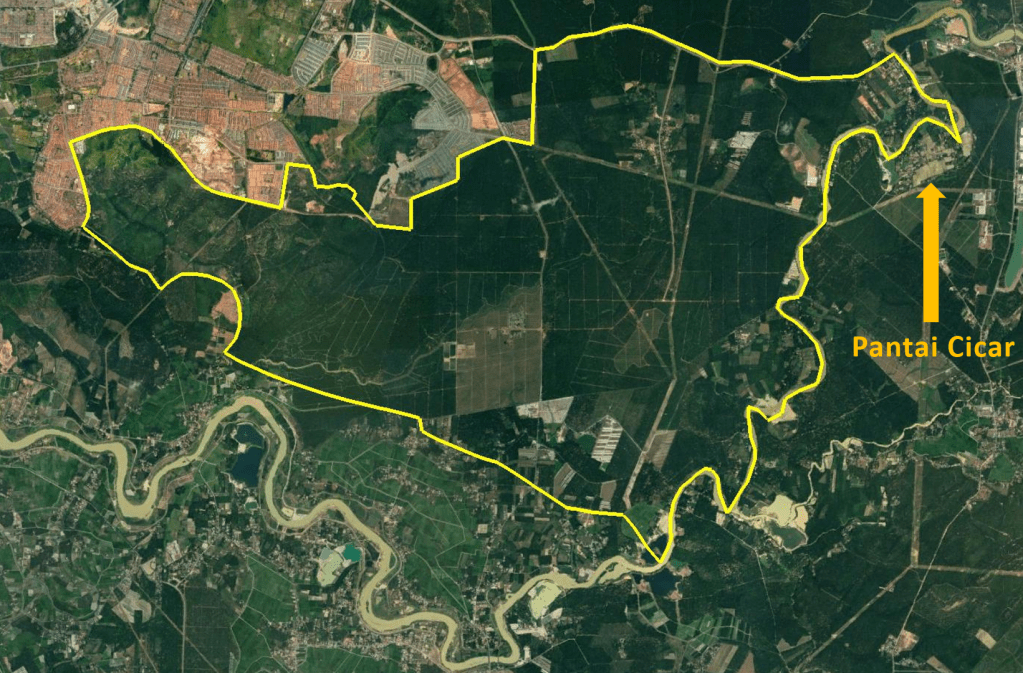
But land acquisition for KXP AirportCity met with a protest by villagers concerned they would lose their land and livelihoods. Many Pantai Cicar villagers were concerned that land they had lived on for almost a century could be lost as it was within the area earmarked for construction of the airport city project. On 28th February 2020 about 300 residents of Pantai Cicar village gathered in front of the mosque to protest against land acquisition for the proposed KXP project. The chairman of a village action committee said the earmarked land included more than 200 houses, the mosque that had been built by the community and the cemetary where their ancestors were buried. Implementation of the airport project would impact upon residents whose main livelihoods are from rubber tapping, working on palm plantations and self-employment.
On 28th February 2020 about residents of Pantai Cicar village protested against proposed construction of KXP AirportCity / Kulim Airport in their village, Sinar Hinan, 2nd March 2020
A video of the 28th February protest against taking Pantai Cicar village land for KXP AirportCity shows a large gathering of people. Some of the banners at the protest are written in English and read:
OUR LAND FOR NEXT GENERATION AND NOT FOR NEW AIRPORT, WHY NEED TO CONSTRUCT NEW AIRPORT AT TRADITIONAL VILLAGES
DON’T TAKE OUR BELOVED VILLAGE, AVOID THE KXP, FROM OUR VILLAGE, MOVE THE KXP TO THE PKNK OWN PROPERTY
DON’T DISTURB OUR COMMUNITY WITH NEW AIRPORT PROJECT
OUR LAND FOR NEXT GENERATION AND NOT FOR NEW KXP CITY & AIRPORT
WE LOVE STAY UNITY. PLEASE DON’T DEVIDE US WITH SPLIT SETTLEMENT, WE DO NOT NEED NEW AIRPORT AT THIS MOMENT
WE LOVE STAY UNITY. PLEASE DON’T DEVIDE US WITH SPLIT SETTLEMENT, DEALING WITH BIAS NOT OUR CULTURE!
At the time of the protest preparations were underway to hand over a memorandum containing almost 1,000 residents’ signatures to the state government. In addition to Pantai Cicar several nearby villages were also listed in the proposed land acquisition: Kuala Sedim, Jerung, Kemumbong, Lubuk Kiab, Batu Pekaka and Tanah Licin. The local government and housing committee chairman said the Kedah state government would investigate and review the project’s impact on the environment, saying planning was just beginning and there would be a discussion session.
Since a Kulim airport project was being considered in 2014 there has been an emphasis on potential air cargo operations. In December 2014 Mukhriz said the Kedah state government planned to construct an ‘aerocity’ at the proposed Kulim Airport; an industrial and business area, located on what was at that juncture specified as a 600 hectare airport precinct, would “accommodate all industries related to air transportation”. In March 2015 Mukhriz said Kulim Airport would initially operate as a cargo facility. In November 2020 KXP was described as ‘an airport city that will be an integral part of the Kedah Aerotropolis economic region driven by intermodal connectivity focussing on cargo, logistics and industrial development’. It is envisaged that Kulim Airport’s cargo facilities and the development of the aerotropolis will be complemented by the Sidam Logistics, Aerospace and Manufacturing Hub (SLAM).
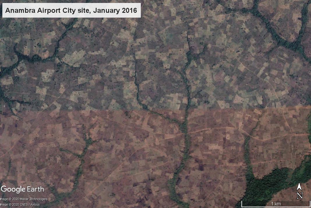
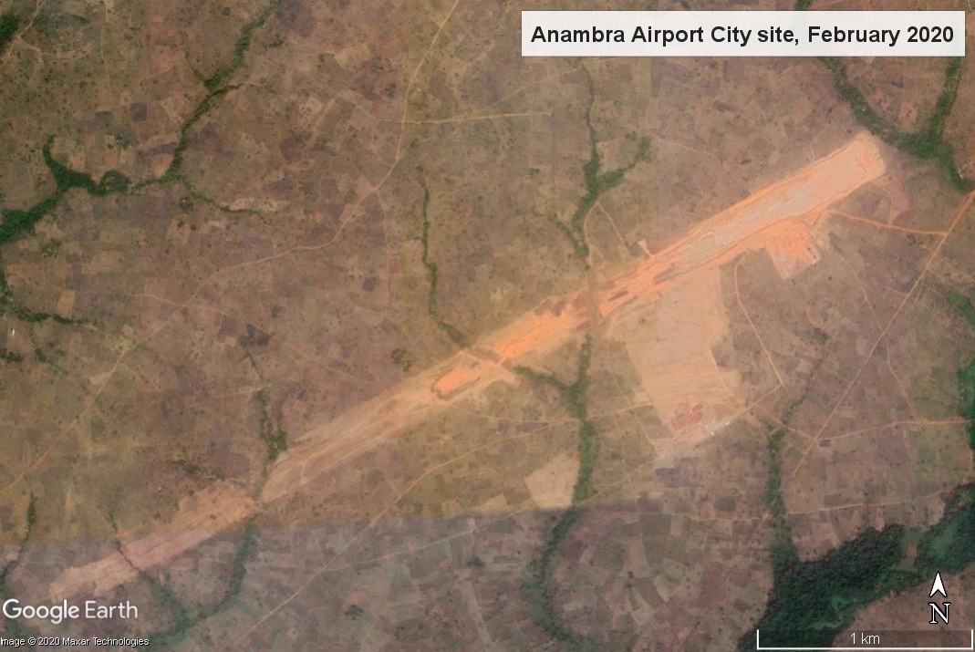
A large area of farmland was cleared for an airport city/cargo airport in Anambra, southern Nigeria and neighbouring communities complain of expansion of the project site and land grabbing. Two satellite images of the site show major changes over a four year period. The image on the left shows the airport site in January 2016, before announcement of the project, containing many plots of farmland. On the right, an image dated February 2020 shows a large expanse of farmland has been cleared for Anambra Airport City runway and other facilities.
Slide bar in the middle of the two images to see changes to landscape from clearing farmland for airport construction
The Anambra Airport City project, also also referred to as Umueri Airport City and Anambra Cargo Airport, was launched in April 2017. A two-runway airport with an airport hotel, business park, international convention centre along with aviation fuel and aircraft maintenance facilities, costing more than USD2.2 billion was announced by the governor of Anambra State, Willie Obiano. Two years later a large expanse of land had been cleared but little work had been done on the site. Igbo Renaissance Council stated that the employment for local people that was promised had not materialized and residents whose homes had been razed to make way for the project had been left ‘dejected and depressed with no sign of hope on the horizon’.
In July 2020 – in the midst of the Covid-19 pandemic, with airports that had been closed since March only slowly recommencing operations – residents of several communities around the Anmbra Airport site complained that government agents responsible for executing the project were encroaching beyond the boundary of the land area that had been allocated. People of Umuopo, Umuinu and Enuagu kindreds in Umueri, north of the airport site, stated that they were being dispossessed of their remaining portions of land and had been “thrown into pains and agony“. They said the government was deliberately making them refugees on their own land. Community investigation revealed that unscupulous individuals were annexing their land and they called on the state government for help, stating:
“By extending their hand into other portions of our land, what does the government expect us to survive with as we are just farmers? We have written, we have cried, we have pleaded and we have engaged in all forms of diplomacy to demand that government restricts itself to the agreed portion of land, all to no avail.”
It was also reported that residents of Ifite Nteje, a community to the south of the Anambra airport project, were suffering from violence meted out by youths who had seized communal land. A band of youths had ‘unleashed mayhem on the community, sacking villagers from their homes’. People opposing sale of their communal land had been beaten with many being injured and homes had been burned down. Members of the community said the crisis had ‘brought hunger and famine as they no longer have land for farming’ and ‘they dared no go to their farms anymore for fear of being maimed, while the women among them were raped’. One woman, a widow, said their formerly peaceful community had been taken over by violence and she was one of many women who no longer had land to farm that they needed to feed their families.
On 14th October 2020 it was reported that youths from the Umueri community had dispersed bulldozers that had been had been stationed, without notice, to demolish farmland and privately owned agro-investments. A farm owner maintained his affected farm was not within the airport area and appealed for intervention from the state government to halt trespassing. On 19th October residents of Umuopo, Enuagu and Umuinu protested against alleged encroachment on their land, lighting a bonfire and blocking the road to the airport site. Some of the placards read: “We can’t be refugees and IDPs in our own land”; “We’re farmers why collect our land to build housing estate”; “Anambra State government go to the portion of land given for the airport.” The protestors described the government’s action as a deliberate attempt to impoverish the people, who were predominantly farmers. The Chairman of Ifite Umueri Community claimed that they had given the government 729.60 hectares for the airport project, but over 1,901 hectares had been taken.
Obiano, Anambra State governor, continues to support the Anambra Airport project, saying it will have the second longest runway in Nigeria after Murtala Muhammed Airport in Lagos. Then on 4th November the Anambra State Government set aside Naira 5.8 billion (USD15.2 million) for completion of the Anambra Airport project during the presentation of the 2021 Appropriation Bill.
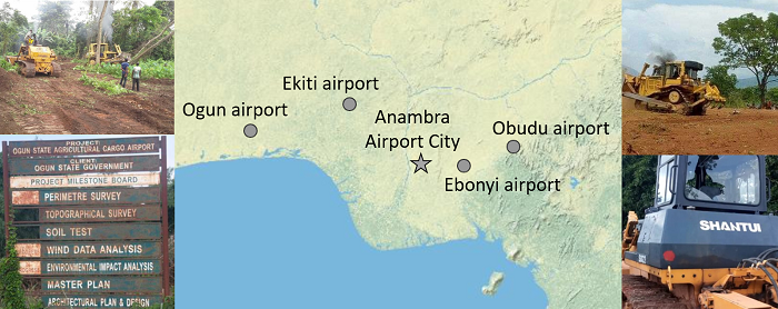
Information about Anambra Airport City/Cargo Airport and its impact on neighbouring communities is a new addition to a cluster of similar airport projects in southern Nigeria, all of which are documented and analyzed in the Map of Airport-Related Injustice and Resistance, a partnership project coordinated by EnvJustice and the Stay Grounded Network. Land has been cleared to make way for proposed cargo airports in Ekiti, Ogun, Obudu and Ebonyi. In all four cases bulldozers arrived without warning and began destroying people’s farmland and crops to make way for airport construction.
In the case of the proposed Ekiti airport bulldozers ripped down trees and cleared farmland before even consulting affected farm owners from five villages. Farmers succeeded in stalling the project and secured a major court victory with all their claims against the state government being vindicated. Hundreds of farmers protested against land-grabbing for a cargo airport in Ogun State. In 2018 it was reported that 5,000 farmers were affected by the project and some had been intimidated and their crops bulldozed. Earth moving equipment began destroying farmland and felling trees in three Obudu villages where land has been earmarked for an airport, flouting project planning and land procedures. Allocation of a large land area for a proposed cargo airport in Ebonyi cargo triggered protests by people facing displacement from their ancestral homes and farmland. Bulldozers began clearing land and destroying crops and landowners raised alarm over imminent hunger in their community.
A plan for a major city extending over up to 600 square kilometres around a new airport in Navi Mumbai diverges from the aerotopolis model of development; the land area and number of villages included in the jurisdiction has reduced.
NAINA (Navi Mumbai Airport Influence Notified Area) originated when the Indian government granted clearance for a second Mumbai airport, in Navi Mumbai. One of the conditions for approval of the new airport was ‘that the Master Plan, Development Plan of Navi Mumbai shall be revised and recast in view of the Airport development and to avoid unplanned haphazard growth around the proposed airport’. Factors considered in assessment of the Influence Zone around the new airport included ‘the requirements of International Airport as per the aerotropolis concept’, connectivity and operation of various planning authorities in the region. Appointment of a ‘Planning Authority for a Planned and orderly development within a radial distance of about 25km from the proposed International Airport site’ was deemed necessary. On 10th January 2013 City and Industrial Development Corporation (CIDCO) was appointed as the Special Planning Authority.
Even at this stage it was evident that NAINA (the pink shaded areas on the map) diverged from the aerotropolis model of development. The designated NAINA area was fragmented and not even contiguous with the Navi Mumbai International Airport site (shown on the map as an orange rectangular area to the west of NAINA). The new jurisdiction, encompassing 270 villages in six talukas in the Raigad and Thane districts, a mix of peri-urban and rural areas, was not the recilinear greenfield site of an archetypal aerotropolis.
A large land area was designated for NAINA, estimated at between 550 and 600 square kilometres (1.5 times larger than the city of Mumbai). Inception of NAINA transferred planning powers to CIDCO; notification specified that all proposals for development permission would henceforth be processed by CIDCO. Land acquisition for the initial phase met with opposition. In 2014, while a survey was being undertaken, residents of the 23 villages notified for development in phase 1 of NAINA (to the east of the Navi Mumbai International Airport site) voiced strong objection saying they were not informed about the project which would adversely affect agriculture, their main source of income.
A spokesperson for the 23 villages said people did not trust CIDCO because farmers who lost their land in the 1970s, for development of Navi Mumbai city, had still not been compensated. Affected families had been promised employment but many were still doing odd jobs to make ends meet. Villagers also raised objections to CIDCO’s practice of providing information in English, a language most of them did not understand. A hearing was rocked by protest and villagers claimed that developers’ land was being treated preferentially, left untouched while theirs was earmarked for public utility purposes.
In an article published in Economic & Political Weekly ‘Fragmentary Planning and Spaced of Opportunity in Peri-urban Mumbai‘ Malini Krishnankutty describes how the Interim Development Plan (IDP) prepared for the first phase of NAINA, encompassing 23 villages, ‘reinforces the planners’ lack of deep engagement with the rural’. NAINA’s role of amassing land for implementation of its master plan exemplified modern urban planning’s disregard for rural areas. Such planning interventions viewed land merely as a resource, the rural as a ‘tabula rasa’ destined for urban development, villages from ‘the narrow perspective of providing very specific social amenities or transport infrastructure’, thus rural villagers and their ways of life were rendered invisible. With regard to NAINA she writes:
‘Once again what is visible here is a superimposition of a vision of a city on these villages, a view of urbanisation that is a foregone conclusion, and a lack of engagement with the future of the villagers, once they are divorced from their lands and livelihoods. There is also no engagement of planners with any idea of conservation, tangible or intangible or of productive farmlands’.
NAINA’s proximity to the Navi Mumbai International Airport site had given impetus to speculative interest in the area. The airport and several major road and rail projects in the pipeline – Mumbai Trans Harbour Link (MTHL), Delhi-Mumbai Insustrial Corridor (DMIC) and a road + rail corridor extending from Virar to Alibaug linking peri-urban regions in the Mumbai Metropolitan Region (MMR) – all require land acquisition by the government that ‘inevitably means dispossession and loss of livelihoods’. In addition these infrastructure projects activate the ‘highway urbanisation’ that is prevalent throught India and the global south. Announcement of new infrastructure triggers commodification of land, opening up rural areas for urban development.
During June, July and August 2015 journalist Rahul Batia travelled along the path of the Virar – Alibaug road and rail corridor running through NAINA, talking with people affected by land acquisition for the project. The route of the road, a transportation corridor 126 kilometres in length and 120 metres wide, stretches from the city of Virar to the north of Navi Mumbai, running southwards through NAINA then curving easwards to the coastal town of Alibaug. On the interim development plan the transportation corridor appeared as ‘a thick white strip snaking through residential areas, growth centres, forests, and urban villages’. Twelve kilometres of the road were within NAINA phase 1 and impacts upon the 23 villages within this area loomed.
NAINA map showing route of road through Nere and other villages. Source: cidco naina
The poorest locals were the most perturbed by the ‘corridor of uncertainty’, believing it would ‘hit them hardest’; some were convinced that they had been ‘singled out for some kind of punishment’. There were allegations that the route being marked out for the road curved to avoid homes and land owned by rich and influential residents. Adivasis at a hamlet in Nere, one of the affected villages, came across a mark painted into an approach road and thought it was connected with the new transport corridor. The sarpanch (head of village) of Nere knew little about the road except that people would be relocated to make way for it, and did not know where they would go to. He had not seen the map of NAINA. Pointing out a notice with a yellow diagonal stripe marked ‘CH 51554’ he said, “They came here, made markings, and left. Nobody told us anything.” Inhabitants of the 23 villages in the first phase of NAINA lived in uneasy uncertainty. NAINA officials were holding consultations but many affected residents complained of a ‘disconcerting lack of information available about exactly what shape NAINA will take’ and said that rates for people wanting to build on their land were ‘exhorbitant’.
Opposition to land-pooling scheme
Unrest over NAINA plans continued into in 2016. In February farmers of 111 villages opposing NAINA united to form a committee, Shektari Utkarsh Samiti, and marched from Khargar to Panvel. They voiced many demands for changes to NAINA policy, including that the amount of their land to be given to CIDCO under the land pooling scheme, whereby groups of land owners hand over their land to a government agency for development of infrastructure, with a proportion of the land being returned to the landowners, be decreased from 40 per cent to 30 per cent. In September representatives of 36 villages in the Panvel taluka (administrative district) immediately to the east of the Navi Mumbai International Airport site, said they did not want to be part of NAINA and wished to be excluded from the plans and instead be included in the Panvel municipality. Together these villages cover 69.6 square kilometres, a substantial proportion of the total NAINA area.
Rajendra Patil, a representative of one of the villages, Kolkhe, said that waiting for finalization of NAINA plans had stalled development in their villages, and that the development model was tilted in favour of big developers whilst working against the interests of local farmers. Anesh Dawale, a former head of Shivkar village, said of NAINA’s land pooling scheme: “It is just a garb to release farm lands held by villagers to the builder lobby”. In particular, local people were of the view that the minimum land pooling norm of 18 acres favoured construction magnates. Dawale also said that the curbing of village council powers under NAINA had a negative impact on civic services, a view shared by Panvel’s MLA (Member of Legislative Assembly), Prashant Thakur.
In December 2016 it was reported that 14 villages on the outskirts of Navi Mumbai and included in NAINA feared losing their land due to the project. Community representatives said that authorities were reserving plots of land without consulting local people and that inclusion in NAINA was blocking development in their villages, in contrast with surrounding areas that were flourishing. The 14 villages repeated demands first made in July 2015 to be merged with the civic body NMMC (Navi Mumbai Municipal Corporation) instead.
NAINA area reduced
NAINA was described as ‘potentially the biggest smart city in India‘ at approximately 600 square kilometres in November 2014 but by May 2016 CIDCO appeared to favour polycentric urbanisation, in the form of ‘30 smart cities‘, Special Economic Zones and growth centres. CIDCO officials estimated that, in its initial years of operation, the new airport would handle two to three million passengers, a fraction of the widely publicised projection of 20 million passengers per year in the first phase, rising to 90 million when expanded to full capacity. By July 2017 many parcels of land in the 1st phase of NAINA had not been acquired due to opposition from villagers. The state urban development department had approved development of the 23 villages three months previously but the development plan was still not publicly available.
Map of NAINA, reduced to 474 sq km, September 2017. Source: CIDCO
CIDCO’s Modified Draft Development Plan for NAINA, published in September 2017, anticipates an inflow of passengers from the new airport, but there is no mention of mulitiple millions of passengers annually. The plan does not include the aviation-dependent tourism or freight facilities that form the mainstay of an aerotropolis. The plan details a substantial reduction in NAINA’s footprint and a map shows further fragmentation of the designated areas. Several villages were transferred to other jurisdictions, becoming part of Maharashtra State Road Development Corporation Limited (MSRDC – a development plan for the area along the Mumbai-Pune Expressway), Matheran Eco-Sensitive zone (MESC) and Maharashtra Industrial Development Corporation (MIDC). Thus the number of villages incorporated in the NAINA plan decreased to 224 and the land area was reduced to 474 square kilometres.
The voluntary land-pooling scheme was causing delays, so, in April 2018, at the request of CIDCO, the state government moved to fast-track the NAINA project by way of invoking town planning scheme (TPS) provisions for compulsory participation of villagers residing in areas encompassed in the development plan. Participation in the project was made compulsory for the 23 villages in Phase 1 of NAINA. A draft plan for this 37 square kilometre pilot area was published, giving villagers just 30 days to make suggestions and objections, enabling CIDCO tosanction the scheme in three months. CIDCO also moved to expedite road building, using a fast-track TPS process, allowing a total of 21 months from announcement to execution.
Diverting water to NAINA
NAINA will take up water as well as land. CIDCO’s September 2017 Modified Draft Development Plan for NAINA calculates NAINA phase 1 water demands to be 8.33 MLD (millions of litres per day) in 2021, rising to 29.75 MLD by 2031 then reaching 45.07 MLD by 2041. New sources of water are anticipated to meet the increasing demands of NAINA and other CIDCO projects: the Balganga dam from which 150 MLD would be available for NAINA and Khopta Area (another CIDCO project) and the proposed Kondhane dam from which CIDCO expects to receive 250 MLD. The state transferred the Kondhane dam project from the water resources department to CIDCO in August 2017. The dam will draw water from the Ulhas river.
Shortage of water supplies is a perennial problem in many areas of Mumbai. In 2018 water scarcity was exacerbated by construction activity for Navi Mumbai Airport, which put pressure on water supplies impacting on surrounding communities, including those within NAINA. By May 2018 Panvel had been suffering a severe water crisis for three months. Every summer water scarcity forced residents to rely on water tankers. But in 2018 the situation was more serious. Many areas in Panvel were only receiving water on alternate days. Villages under NAINA were only getting water every three or four days. A resident of Khanda colony, Vishnu Gavali, filed a public interest litigation (PIL) requesting the court to direct civic authorities to resolve the issue. The PIL states that, under the constitution, all citizens have the right to food, water and a decent environment, and that CIDCO was failing in its duty to provide basic amenities. Gavali said “As airport work has started, a lot of water is being used for the construction activities but sadly, the locals have been neglected.” A resident of Roadpali said “Cidco has given permissions for so many upcoming projects in the city, I don’t understand how they would fulfill water needs of so many projects.”
In March 2019 residents of Panvel gathered near the CIDCO water tank premises in protest over poor and erratic water supplies, denying their fundamental rights to a basic amenity. Leader of the delegation, Apoorva Prabhu, said they had suffered water scarcity for six months and were requesting regular water supplies of least two hours daily. In September 2019, with many areas facing water shortages, CIDCO took measures to ensure that NAINA would not be affected by the water crisis. A detailed project report (DPR) on Kondhane dam, to help ensure adequate water for NAINA, was expected to be completed within a year and revive the project.
Objections to NAINA plans
On 28th June 2019 the Times of India reported that the urban development department would publish the final approved plans for NAINA and Maharashtra State Road Development Corporation Limited MSRDC after the monsoon season. Citizens demanded the government publish the report of the planning committee on the objections and suggestions made by the public in order for there to be transparency over whether or not these concerns raised were addressed or not. Pankaj Joshi, architect and executive director of the Urban Design Institute said “Objections were raised to the government proposing industries in green zones in the metropolitan regional plan. The entire green belt will become brown if it is approved.”
Map of NAINA September 2019, area shrunk to 371 sq km. Source: Times of India
By September 2019 NAINA, promoted as India’s largest planned city in 2014, had shrunk to just over half its original size. The plan for a new city, spread over up to 600 square kilometres of land, had shrunk substantially, now occupying a 371 square kilometre plot. The map indicated further fragmentation of the NAINA area and the number of villages incorporated in the plan had reduced from 270 to 175. The most recent government notification granted sanction for the development plan for the remaining 152 villages covering 334 square kilometres, along with the 23 villages included in the 37 square kilometres allocated for phase 1.
Unrest among farmers affected by land acquisition for NAINA was reported again in January 2020. A protest against CIDCO had already taken place and farmers were planning further agitation. Several local leaders were raising their voices against the scheme. By 17th March CIDCO was reportedly ‘going ahead aggressively’ with implementation of NAINA, in the face of unrest by impacted people. About 10,000 farmers from the 23 villages of the first phase of NAINA were planning a demonstration. The farmers alleged that the town planning scheme was not beneficial to them and demanded a review. Vaman Shelke of NAINA Prakalpbadhit Shetkari Utkarsh Committee (NPSUC) said they were given notice if carrying out any construction work on their land, leaving them with no option but to accept the scheme. “This is a participatory scheme and we cannot be forced to join” said Shelke, explaining that farmers were demanding return of 50 per cent of developed land under the land pooling scheme instead of 40 per cent, along with additional benefits for loss of their agricultural land.
Around the world communities are opposing new airports, expansion of existing airports and aerotropolis/airport city developments. A total of 67 cases have now been documented and are published on the Global map of aviation-related socio-environmental conflicts. Several cases and some of the emerging themes are outlined in this short introductory video. The map is a joint project of EnvJustice and the Stay Grounded Network.
Links to airport conflict cases mentioned in video:
Six more aerotropolis-type developments have been added to the Global Map of Aviation-Related Socio-Environmental Conflicts. All the projects – in the USA, Canada, Jamaica, India and China – have met with opposition from affected communities and/or environmental groups. In each case the site, or proposed site, covers a large land area. Launched in July 2019, the map is a joint project by the EnvJustice project and the Stay Grounded network. There are now 67 cases on the map. The new aerotropolis-type additions are listed below. Please click on the links to read the case reports which contain a wealth of information on the environmental and social justice impacts of the aerotropolis projects, the government bodies and firms that are responsible and how affected communities are fighting for their rights.
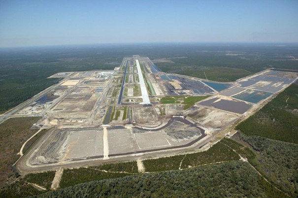
Northwest Florida Beaches Airport
In the USA, a private landowner stands to benefit from industrial, defence, retail and hotel development on land it owns around Northwest Florida Beaches Airport. Construction of the airport, located in the midst of forested wetlands providing a haven for black bears, red-cockaded woodpeckers and the endangered gopher tortoise, caused a decline in in spite of six environmental lawsuits. After the airport opened in 2010 a 404 hectare ‘airport city’ began taking shape on adjacent land. In December 2019 the landowner broke ground on a hotel next to the airport.
In California, a massive air cargo project, Eastgate Air Cargo Facility, is planned in San Bernardino, an area where residents already suffer health problems caused by high levels of air pollution from a concentration of logistics traffic. The site is 41 hectares and the project also entails new taxiways and an aircraft parking apron at San Bernardino Airport, construction of new driveways to the project site and two bridges. Hundreds of people have attended a church gathering and a hearing on the project. Workers, community and environmental groups, united under the banner SB Airport Communities, are campaigning for a ‘community benefit agreements guaranteeing well-paid, secure jobs along with measures to limit air pollution’.
In Ontario, Canada, groundbreaking for Hamilton Aerotropolis, identified by authorities as a strategic priority in 2005 and subsequently re-named Airport Employment Growth District (AEGD), has commenced. A 555 hectare area of productive farmland around Hamilton Airport has been allocated to the project, which was approved in spite of local opposition, over many issues including the costs to taxpayers and availability of alternative sites on brownfield land, sustained over a long period.
Vernamfield Aerotropolis and Logistics Hub project
In Jamaica communities are concerned they may face forcible eviction for the proposed Vernamfield Aerotropolis. A letter sent to residents in December 2019 gave residents the impression that the “stage had been set for a massive land grab”. The total site area is 2,428 hectares of land, some of which is among the most fertile in the country and had been used to cultivate sugarcane, is a key component of a broader Logistics Hub plan which spans the southeast coast of the island.
Vernamfield Aerotropolis is a key component of the Jamaica Logistics Hub project. Image: Jamaica Logistics Hub, 9th February 2016 https://www.youtube.com/watch?v=3v5hWd9tcLc
Shivdaspura Aero City
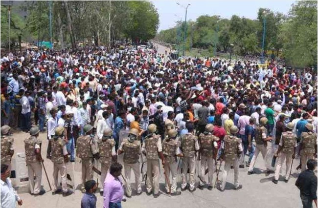
In the Jaipur District of Rajasthan, Northern India, residents of 20 villages have organized major protests against plans for an aerotropolis-type development called Shivdaspura Aero City, a ‘greenfield airport’ (on undeveloped land) along with hotels, shopping malls, cinemas, restaurants and a cargo hub. A series of protests by farmers affected by land acquisition began in January 2018. Landholders say they have been left in lurch” unable to develop or sell their land. The site is about 2,100 hectares and approximately 80,000 people are affected by land acquisition.
Sanya Hongtangwan International Airport, Hainan, China
Scheduled to cover an area of 26 square kilometers on an artificial island Sanya Hongtangwan International Airport is expected to be a gateway to Southeast Asia and the South China Sea. In addition to the airport and to support its operations an aviation economic zone, seaport operation area, international aviation CBD (central business district) and industrial zone will be built. Environmental activists raised concerns over damage to wildlife including coral reefs and Chinese white dolphins, listed as ‘vulnerable’ in the on the International Union for Conservation of Nature (IUCN) Red List of Threatened Species. They achieved a partial victory, halting the airport island reclamation project for more than two years.
A global map of socio-environmental conflicts and justice movements related to aviation-related projects includes 60 cases that have already been analyzed. The map provides a wealth of information on how people and the environment can be negatively impacted by new airports and expansion of existing airports. Affected communities contend with a multitude of injustices: eviction, land dispossession, loss of farmland and fishing grounds, destruction of ecosystems, construction work impacts and health damage from aircraft pollution and noise once airport projects become operational. More than 300 such cases around the world have been registered in the research project, conducted by the EnvJustice project and the Stay Grounded network.
Map of aviation-related conflicts and environmental justice movements around the world
Several aerotropolis or airport city projects, i.e. substantial commercial and/or industrial development constructed or planned on land surrounding or adjoining an airport, are documented and analyzed. Examples include Kertajati Airport and New Yogyakarta International Airport in Indonesia, both of which involved forcible eviction of communities from several villages from their homes and farmlands. In Cambodia, the government has approved a plan for a new Phnom Penh Airport, one of the world’s largest airports by land area, along with an associated ‘airport city’. The proposed site, predominantly agricultural land, encompasses land that Kandal Stueng villages have resided on for two decades, including communally held wetlands. About 2,000 families could be affected and hundreds of people have protested against the development.
In India, Andal Aerotropolis is a private airport city development that was stalled by sharecroppers protesting delays in receiving compensation for land taken for the project. Landowners from seven villages in Purandar sustained resistance against loss of their homes and farmland for a new airport since the location of the project was announced in 2016. Then in 2018 it was reported that the state government was forming a consortium to drive investment in an ‘airport city’ around the airport. Villagers’ resistance against displacement from their farmland for Bhogapuram Aerotropolis, also referred to as an ‘aerocity’, succeeded in reducing the land area allocated to the project from 6,000 hectares to 1,122 hectares, along with securing higher compensation for a group of farmers.
A plan for a new airport on the Arial Beel wetlands in Bangladesh is an example of a aerotropolis-type megaproject that was halted by mass mobilisation. A vast swath of land had been earmarked for development, 10,117 hectares for the airport and an accompanying ‘satellite city’, and the farming and fishing livelihoods of thousands of people were set to be seriously affected with wetlands paved over. The government cancelled the project after major protests, the largest of which involved 30,000 people. In the Philippines, mangroves, coastal wetlands providing a vital habitat for many species and protection from erosion and flooding, have already been destroyed to make way for the proposed Bulacan Aerotopolis which threatens to destroy fishing livelihoods. Airport projects can entail deforestation. In Nepal, the proposed Nijgadh Airport, a massive 8,000 hectare aerotropolis, raises the prospect of over 2.4 million trees being felled.
A number of airport projects shown on the map are key components of tourism development schemes that are based upon aviation dependency. A proposed new airport on the Island of Fainu, in The Maldives, is accompanied by a plan for an adjoining hotel. The project would destroy a long stretch of white sand coastline, dense forest and agricultural land, the airport and hotel projects combined swallowing up much of the small island. Another example is the Philippine island of Sicogon where, in the aftermath of the devastation wreaked by Typhoon Yolanda, developers seized upon the opportunity for tourism development, the first phase of which includes an airport specifically for tourism along with beachfront accommodation. Disaster capitalism is also evident in the Caribbean island of Barbuda where land clearance for construction of a new airport, intended to support tourism growth in particular high-end resorts, began shortly after residents were evacuated following Hurricane Irma.
The map includes two major airports built to support fossil fuel projects. Uganda’s second international airport, Hoima Airport, currently under construction, is a key component of the 29 square kilometre Kabaale Petrochemical Industrial Park. With a 3.5 kilometre length runway, capable of accommodating the world’s largest cargo aircraft, it is envisaged that in its first phase of operations Hoima Airport will handle delivery of heavy equipment for the oil refinery on the site. In a similar vein, Komo Airfield, in the southern highlands of Papua New Guinea, has the country’s longest runway and was built for delivery of heavyweight and outsize equipment for the ExxonMobil led PNG LNG (liquefied natural gas) project.
A number of cases shown on the map involve allocation of larger areas of land than would be required for aviation operations, increasing the number of people potentially facing displacement due to land acquisition, but without clear information on what the excess land might be utilized for. For example, in Nigeria the Cross River State government intends to acquire 900 hectares of land for a proposed Obudu International Passenger and Cargo Airport and people have been evicted from their homes and farmlands. In a similar case in Nigeria, bulldozers arrived without warning to clear 4,000 hectares of farmland where crops including cocoa, palm trees and bananas were cultivated for a cargo airport in Ekiti. This airport project is one instance of a successful court case where affected people secured a court victory that halted the airport project. Also in Nigeria, about 5,000 people from 20 villages could be affected by a proposed Ogun cargo airport and hundreds of farmers protested against land-grabbing.
The map of aviation-related conflicts and environmental justice movements is an ongoing project in development coordinated by the EnvJustice (ICTA-UAB) project and the Stay Grounded network. In addition to the 60 airport-related cases already included, a great many further cases have been registered as meriting further investigation. A total of 300 cases have been registered. The information gathered for the global map has been provided by a wide variety of organizations, local collectives and academics. The research team is coordinated by Rose Bridger (Stay Grounded) and Sara Mingorria (ICTA-UAB). This already substantial database and interactive map related to airports is part of Ejatlas, the biggest global inventory of socio-environmental conflicts around the world. As of 11th July 2019 2,831 cases were registered on Ejatlas and this is anticipated to increase to 3,000 cases by the end of the year.
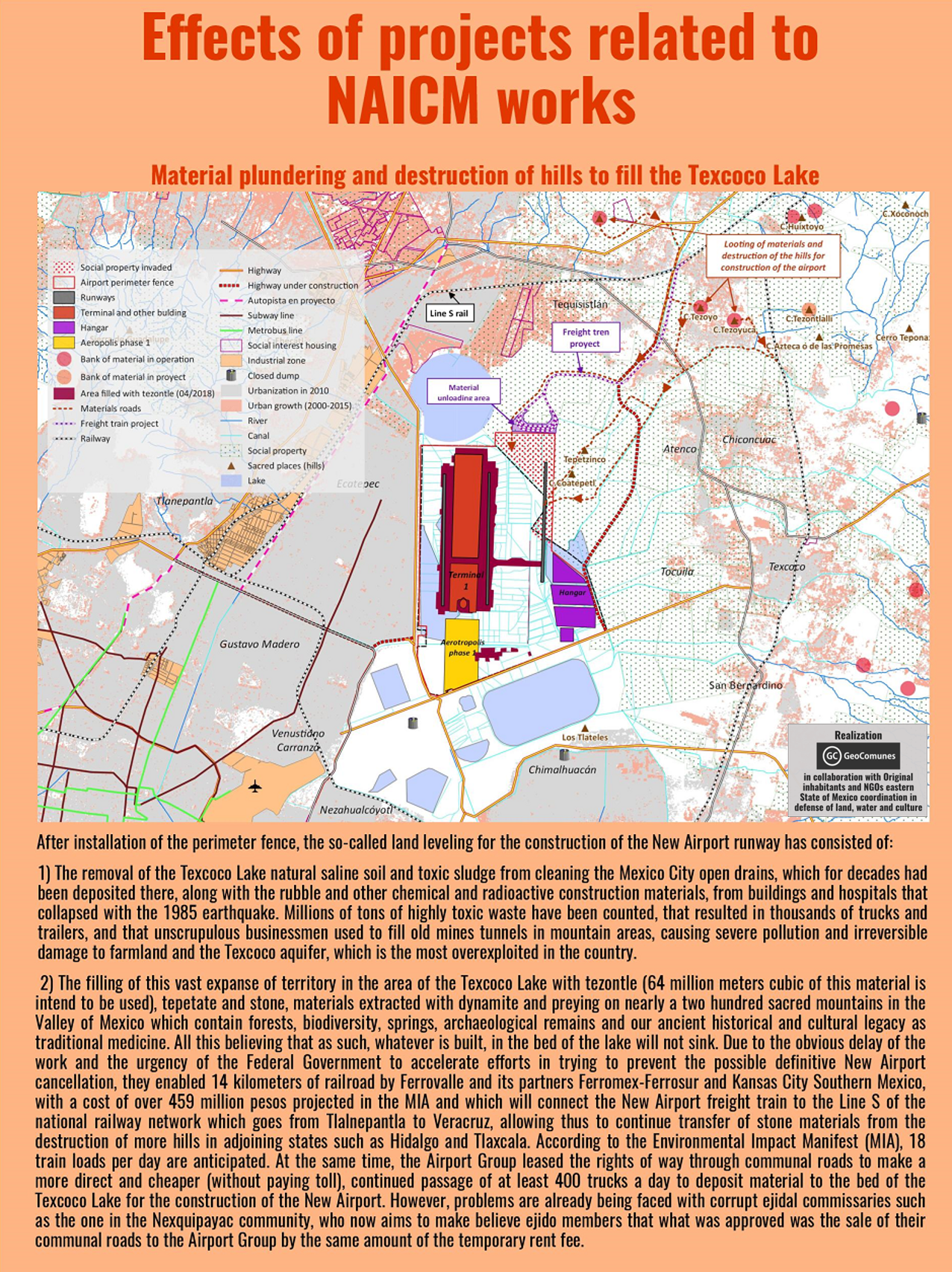
GAAM is delighted to share an incredibly informative set of maps elucidating the complex socio-economic and environmental impacts of construction of New Mexico City International Airport (NAICM). The maps were produced by GeoComunes, a collective working with communities to use maps as an analytical tool to strengthen the struggle for defence of common goods, in collaboration with affected residents and NGOs supported by Coordinadora de Pueblos y Organizaciones del Oriente del Estado de México (CPOOEM), which supports people’s defence of land, water and culture in eastern Mexico. The NAICM site, covering over 4,431 hectares, is the waterlogged Texcoco lakebed. Aerotropolis development is planned: a specific area within the airport site and commercial and industrial development over an extensive area surrounding it.
The first map, below, shows uncontrolled urbanization between 2000 and 2015, preceded by highway expansion, driven by real estate and encroaching on ejidos (communally held agricultural land) near the shores of Texcoco Lake. Landfill sites receiving waste from Mexico City have damaged farmland and polluted aquifers. The airport site is in the ‘Zona Federal’ area in the centre of the map. The existing Mexico City International Airport (officially named Benito Juárez International Airport) is shown near the bottom of the map.
A perimeter fence has been erected around the NAICM Phase 1 project area. The site includes ejidal lands, in spite of assurances that the airport would be built entirely on federally-owned land. Ejidal lands were also appropriated for a highway and housing developments, and many Ejidos (land holders) were violently evicted by state security forces. Plans for Aerotropolis phase 1 include a shopping mall, hotels, industrial park, exclusive high-end housing, golf courses and a free trade zone.
The third map shows satellite imagery of the three Ejido areas directly affected by airport construction. Over 330 hectares of ejidal lands, in the communities of Ixtapan, Nexquipayac and Atenco, were seized from its rightful owners by the government and now lie within the NAICM perimeter fence.
Land-levelling to prepare the site for construction of the airport involved clearing saline sludge from the lakebed and toxic waste that has been dumped, polluting the Texcoco aquifer and damaging farmland. Extraction of materials for use in has had a devastating impact on sacred mountains, in the Valley of Mexico. Blasting with dynamite has damaged, forests, biodiversity, springs and archaeological remains. It is estimated that 64 million tonnes of tezontle (red volcanic rock) along with stone and other materials, carried on 400 trucks per day, will be deposited to fill in the Texcoco lakebed.
Water drained from the Lake Texcoco area will be channelled into Nabo Carrillo, an artificial lake and newly created lagoons, along with water from the area east of the airport site channelled via several culverted rivers. Lying at the bottom of a downward slope the airport site is at risk of flooding from concentration of water flow in this area. The flood risk could become more severe as Texcoco lakebed is sinking at a rate of about 12 inches annually.
An extensive road network linking NAICM to key urban centres is planned and under construction, encroaching on ejidal land and opening up additional land for real estate and commercial development. Many of the roads are toll roads which will generate profits for construction firms holding the concessions and thus set to benefit from the traffic flow.
Data from all the maps is combined in the final map, which covers a wider geographical area revealing the extent of the urbanization that is underway and planned. See the larger version of the map for more detail. NAICM is shown within a wider context as the most important of, and the focal point for, a series of megaprojects combining to form a ‘Megalopolis’, an agglomeration of cities and other urban areas. New road and rail corridors will foster further real estate development. Mexico City already suffers chronic water shortages and springs and groundwater are over-exploited. The current model of urbanization will increase stress on water supplies and aqueducts are planned to access more distant sources.
All the maps of NAICM and aerotropolis plans can be seen here in their entirety and are best viewed on the largest computer screen that you can find so you can zoom in and see the intricate detail.