Moves to acquire land, including fertile farmland, in six villages to the south of Guwahati Airport for a proposed Aero City and Satellite Township have raised fears of eviction in a larger area encompassing about 16 villages.
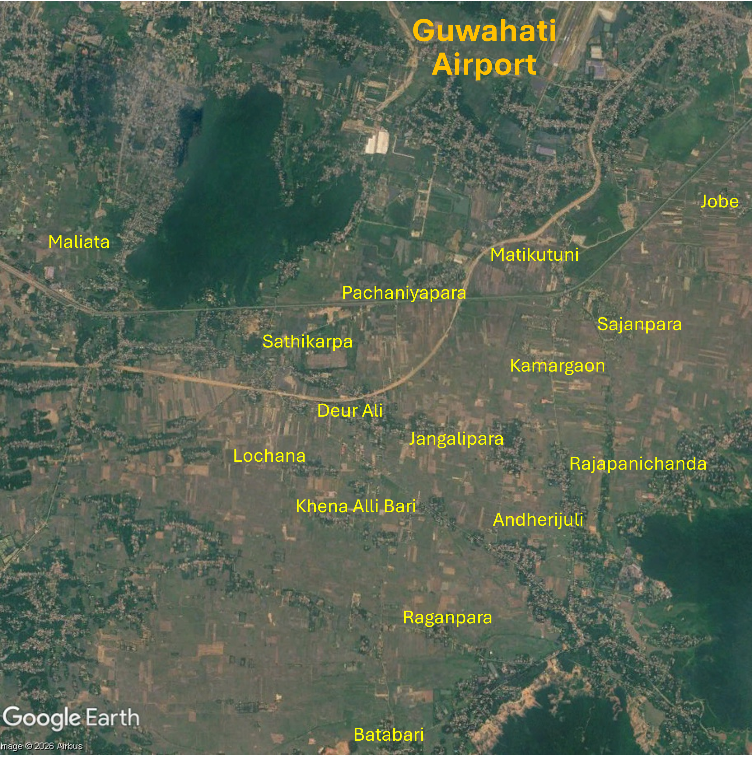
On 26th June 2026 The Assam Tribune reported that residents of 16 villages in the Azara and Palasbari sub-districts, to the south of Guwahati Airport, feared eviction due to land acquisition for a proposed Aero City and a Satellite Township. No official eviction orders had been issued but residents of 16 villages – Andherijuli, Batibari, Deur Ali, Jobe, Jangalipara, Kachari Allibari, Kamargaon, Lochana, Matifuturi, Maliyata, Pachaniyapara, Patgaon, Rajapanichanda, Rangapara, Sajjanpara and Sathikarpa – were worried that land acquisition might be impending as revenue department activities had increased. There were reports that notifications for valuation and acquisition of agricultural land had been issued in six of these villages – Deur Ali, Jangalipara, Jobe, Kamargaon, Matifuturi and Pachaniyapara – where officials were collecting land-related documents. Farming is the only source of livelihood for many affected people and they were uncertain about provision of rehabilitation if their land was acquired. Tribal organisations voiced concerns that placing tribal areas under Guwahati Metropolitan Development Authority (GMDA) control might erode indigenous communities’ land rights, administrative autonomy, constitutional safeguards and the powers of the Rabha Hasong Autonomous Council. A number of tribal organisations including Rani Regional Tribal Sangha, Rani Regional All Bodo Students’ Union and Rani Regional Rabha Students’ Union submitted a memorandum to Chief Minister Himanta Biswa Sarma calling on the government to protect the rights and interests of indigenous communities in the proposed project area. A total of approximately 6,662 bighas of land had been earmarked for the two projects, about 2,662 bighas for the Aero City and the reminder for a Satellite Township.
More than 100,000 people fear displacement
Northeast Now reported that more than 1 lakh (100,000) people feared displacement for the proposed Aero City and Satellite Township. Land acquisition raised concerns in six villages inhabited mainly by Bodos, Rabhas, and Koch Rajbongshis people. Official GMDA Chief Executive Officer communication with the Special Chief Secretary of the Housing and Urban Affairs Department explained that the proposed acquisition encompassed 712 bighas in Kamargaon, 676 bighas in Deorali, 553 bighas in Pachaniara, 280 bighas in Jonglipara, 238 bighas in Matikotuni and 203 bighas in Jobe. Residents established Ucched Virodhi Bhumi Adhikar Sangram Samity (UVBASS) to oppose the proposed land acquisition and memorandums were submitted to The Chief Minister, local Member of the Legislative Assembly (MLA) and other senior officials. UVBASS president Dharmeswar Boro said, “If they go ahead with this proposal, more than one lakh people across 16 villages will be displaced” and that by planning the projects the government was “rolling out the red carpet for corporates”.
Opposition to large-scale acquisition of agricultural land
Two farmers’ organisations, Sangrami Krishak Shramik Sangha and Anti-Eviction Land Rights Struggle, held a press conference on 26th June demanding withdrawal of land acquisition processes that they claimed threatened displacement of thousands of families and destruction of fertile farmland. They said the government sought to acquire large areas of agricultural land for an Aero City, Satellite Township, Guwahati Airport expansion and other urban development projects, without providing adequate compensation or rehabilitation. The groups said about 500 families had already been evicted without fair compensation or rehabilitation and that if land acquisition plans move forward about 150,000 families might eventually be affected. They stated that nearly 2,662 bighas of agricultural land in several villages including Jobe, Jangalipara, Kamargaon, Matiya and Pachim Garal had been earmarked for acquisition. Sangrami Krishak Shramik Sangha spokesperson Dinesh Das said the government prioritised corporate interest over farmers, saying, “The government has stopped issuing treasury tax receipts and has deprived people of land rights. Instead of securing the future of farmers, it is preparing to hand over fertile agricultural land to companies for projects like Aerocity and Satellite Township. Farmers are being neglected while corporations are being favoured.” The organisations had made many appeals to the Chief Minister, Governor, Kamrup district administrations and MLA but the land acquisition process continued. The groups also raised concerns about potential impacts of the projects on wetlands and continuing conversion of agricultural land for commercial purposes adversely impacting on food production.
Protest and warning of ‘mass agitation’
On 2nd July 2026, hundreds of residents protested outside the Palasbari revenue circle office, opposing the Aero City and Satellite Township project and possible eviction. Together with families concerned they might be evicted from areas surrounding Guwahati Airport they marched along the National-Highway 17 in Mirza. Many protesters were from the Rani area mainly inhabited by Bodos and Rabhas people, where land surveys identifying non-tribal residents were underway. UVBASS sent a memorandum outlining their concerns over reports of GMDA preparing development of new townships in 17 villages to the Chief Minister. The memoranrum stated, “The primary livelihood of lakhs of people in this vast region is agricultural and animal husbandry. The construction of a ‘township’ will bring a severe crisis to the life and livelihood of this huge number of poor people.” Sangrami Krishak Shramik Sangha spokesperson Dinesh Das alleged that evictions were planned in Khena Alibari village where many residents do not have the official documentation required to live in legally protected tribal areas. He demanded protection and provision of land ownership certificates for the approximately 300 Hindu and Muslim families living in the village. The memorandum also raised concerns about land surveys underway in Parli and Majirgaon, north of Guwahati Airport and close to the newly inaugurated second terminal.
At a Nikhi Rabha Jatha Parishad (NRJP) press conference in Guwahati president Babul Chandra Rabha and general secretary Gobinda Rabha said the Assam government was pursuing major land acquisition without consulting the Rabha Hasong Autonomous Council, Gram Sabhas or local residents. The organisation said the Aerocity and Township projects entailed acquisition of agricultural and forest areas along with ancestral settlements, violating constitutional, legal and land rights of indigenous communities, placing the livelihoods and culture of thousands of families relying on agricultural, fishing, husbandry and forest resources at risk. NRJP demanded immediate cancellation of the Aerocity and Satellite Township projects, publication of the environmental and social impact assessment reports for the Ukiam River Dam project which would significantly impact agriculture and fisheries and withdrawal of another proposed Satellite Township, Barduar Bagan, south of the area earmarked for the Aerocity. NRJP warned that, should the government fail to hold discussions with local communities and the Rabha Hasong Autonomous Council, it would initiate mass agitation against the projects, in collaboration with other organisations such as Sangrami Krishak-Shramik Sangha and the Anti-Eviction Land Rights Struggle Committee.
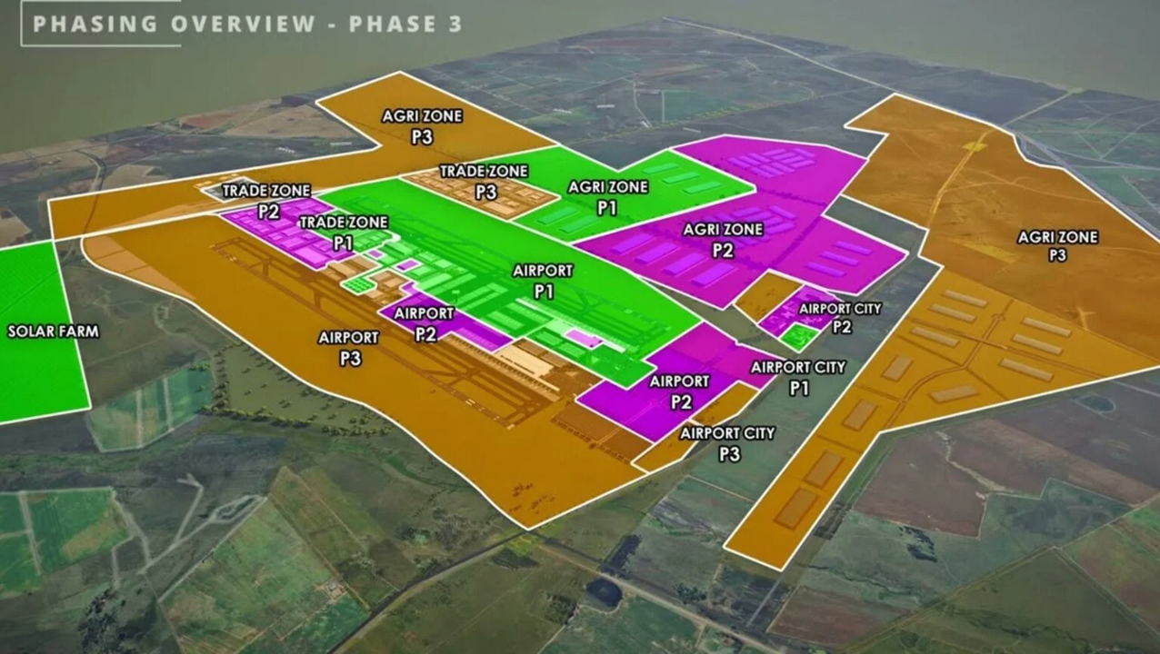
Regulation and financing for the Aero City
Development of regulation and financing to support Guwahati Aerocity and other urban development proceeded quickly. Formation of the Guwahati Satellite Cities Development Authority (GSCDA) a government-owned Special Purpose Vehicle tasked with planning, financing and developing various types of satellite townships within the jurisdiction of the GMDA was approved by the Assam Cabinet on 13th June 2026. Times of India reported that the Guwahati Satellite City Development Authority Bill, 2026 was tabled on 9th July in the face of opposition from many groups in the outskirts of Guwahati. The Bill seeks to grant the authority ‘powers to develop integrated townships, knowledge cities, aviation cities, logistics hubs, tourism zones, economic corridors, commercial centres and other planned urban projects within notified Satellite City Development Areas or areas under its jurisdiction’. Presenting the Budget on 10th July 2026 Assam Finance Minister Jayanta Mallabaruah unveiled plans for what is presumably another name for the Aero City project, an ‘Aerotropolis’ with industrial and commercial districts around Guwahati Airport, to be implemented by the GSCDA. The Budget allocated ₹2,100 crore (USD220 million) for land acquisition for the projects.
Adani prioritises airport city development
The operator of Guwahati Airport, Adani Airport Holdings (AAHL) – India’s largest private airport operator and a subsidiary of Adani Enterprises Ltd. (AEL), one of India’s largest multinational conglomerates – has adjusted its strategy and corporate structures to prioritise airport city development. In December 2025 Adani announced a shift in focus to prioritisation of urban development at its airports, integrating aviation with real estate and diversification of revenue streams. A key element of this strategy is development of airports, in cities including Guwahati, into urban destinations with retail, hospitality, entertainment venues and office space plus a new emphasis on development of in-house hotels. A key driver of Adani’s focus on city-side development is the higher yields, often exceeding 20%, from non-aeronautical revenue streams – such as retail food and beverages – than the typical yield of about 12% from aeronautical sources including landing and passenger service fees. On 6th April 2026, AEL established three wholly owned subsidiaries for real estate activities on land parcels surrounding its hub airports: Adani Navi Mumbai Airport City Limited (ANMACL), Adani Guwahati Airport City Limited (AGACL), and Adani Ahmedabad Airport City Limited (AAACL). These subsidiaries will focus on development and leasing of buildings and management of hotels, restaurants and business centres. On 25th June 2026 AAHL subsidiary Adani Airport City Limted (AACL) announced plans for the first phase of an ‘ambitious programme to develop integrated airport cities across its airport network’. A Rs 20,000 crore (USD2.07 billion) investment aims to transform six airports – Mumbai, Navi Mumbai, Ahmedabad, Lucknow, Jaipur and Guwahati – into ‘mixed-use urban destinations’ with hotels, offices, shopping and dining outlets, entertainment venues and convention centres.
Aerotropolis land acquisition notice in 2025
Opposition to a proposed Aerotropolis near Guwahati Airport dates back to 25th July 2025 when a land acquisition notice encompassing 400 bighas of land in Azara, Garal and Mirzapur, north and northeast of the airport, met with anxiety, anger and opposition from many affected residents. More than a thousand families feared loss of their homes and livelihoods. In Garal village critics of the project claimed the land acquisition process lacked transparency, consultation or a clear plan to rehabilitate affected people and that the main beneficiary would be a private company. Affected families began to protest the land acquisition process, demanding transparency, thorough impact assessment and rehabilitation guarantees. Leader of the Opposition Debabrata Saikia described the move to acquire land for the Aerocity as anti-indigenous and serving corporate interests, saying that more than 1,116 families had received eviction notices, some of whom had held land titles for nearly 200 years. Villagers attending a public meeting in Mirzapur unanimously resolved not to give their land to the government under any circumstances, declaring, “Our land is our identity and livelihood. We will not give it away at any cost.” At this stage of the Aerotropolis residents were already concerned that development of the project might eventually require an area as large as 6,000 bighas, triggering further land acquisition.
For more information including references for all source material and photos see the case report on EJAtlas, the world’s largest, most comprehensive online database of social conflict around environmental issues – Guwahati Airport expansion and Aerotropolis, Assam, India