About 100 indigenous Lumad families have been displaced from their homes and farmland for Bukidnon Airport and there are reports of poor conditions at the relocation site and lack of permanent shelter for some affected people. A key purpose of the new airport is export of agricultural produce from the ‘agricultural heartland’ of Mindanao.
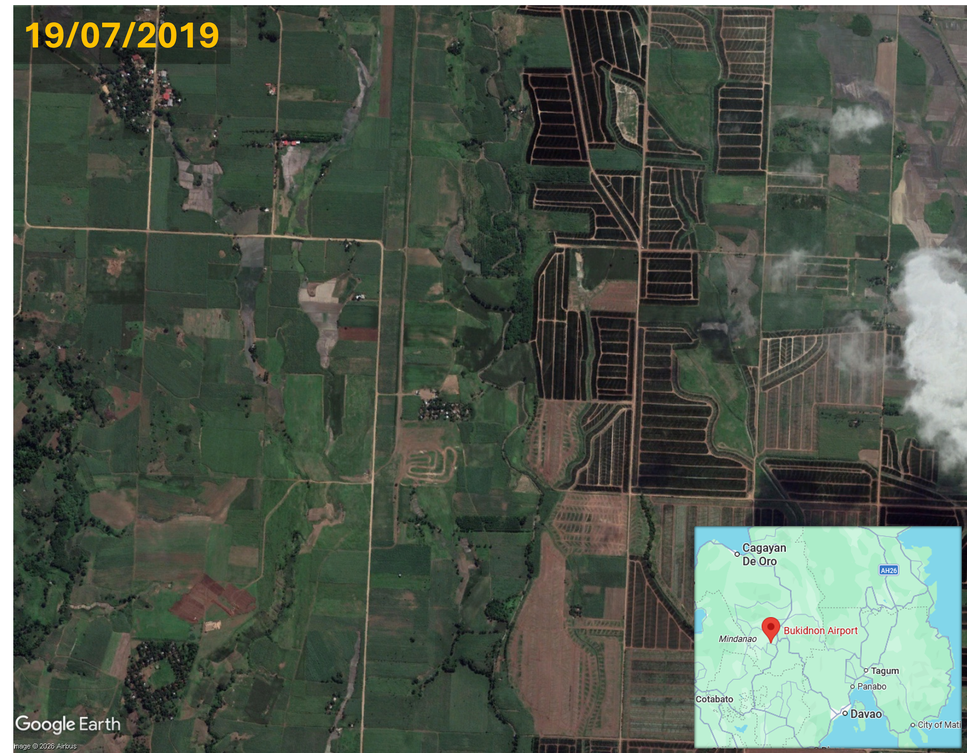
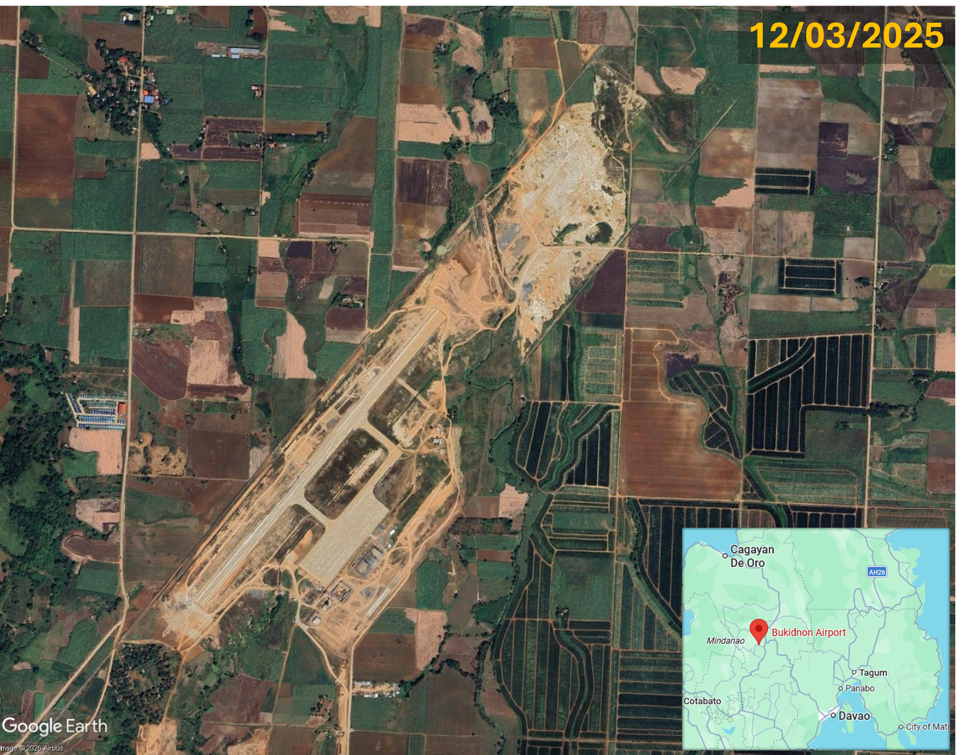
Timelapse aerial imagery of the Bukidnon Airport site and surrounding area, showing changes between 19th July 2019 and 12th March 2025
Construction of Bukidnon Airport, in Barangay Maraymaray, Don Carlos municipality, Bukidnon province, Northern Mindanao, has caused displacement of about 100 Lumad families, indigenous people belonging to the Kirintëkën-Ilantungën Mënuvu tribe, part of the Erumanën në Mënuvu group with ancestral territory in the Bukidnon and Cotabato provinces. One of the affected people said the relocation process was rushed, there was tree felling in the area and new housing units were not yet completed. A woman said dust from airport construction forced them to relocate and their newly laundered clothes were stained brown. A local leader said a large portion of the 149 hectare airport site is within indigenous territory, including 49 hectares recognised under a certificate of ancestral domain (CADT). A local leader criticised the free, prior and informed consent (FPIC) process, saying that instead of consulting the entire community, only two people were asked for permission. In 2018, when the airport project began, indigenous leaders created a draft agreement for the FPIC process, proposing involvement in airport management, a fair share of royalties, allocation of a two hectare showcase area for the Lumad community and fair relocation for affected families. In February 2023 the indigenous people’s organisation of the Tigbabao-Dokit clan issued a resolution calling for a halt to airport construction on the grounds of lack of a proper FPIC. Now, at the relocation site, families report poor conditions with no water or electricity supply. A Don Carlos indigenous representative said about 30 families, some of them not Lumads, were not included in the list of beneficiaries entitled to permanent shelters; some of them were staying with relatives. He also said displaced people did not receive compensation for crops that were uprooted, and they have no land for farming.
The Bukidnon province is known as the ‘agricultural heartland’ or ‘food basket’ of Mindanao and a key purpose of the new airport is export of agricultural produce. The airport is anticipated to enable transport of produce including pineapples, bananas, coffee, corn and sugar, along with livestock. Bukidnon Airport has a 2,100 metre runway, two stub taxiways, a 43,050 square metre apron with space to accommodate six aircraft and a 3,600 square metre passenger terminal with capacity for 425 passengers. Initially the airport will handle turboprop planes, but a longer 2,500 metre runway to handle large aircraft such as the Airbus A320 will be constructed. Since 2022, Bukidnon Airport has received P3.17 billion (USD 50,585,655) in government funding. In September 2026 infusion of an additional P300 million (USD 4,787,400) was announced, for completion of the facility in 2027. This extra funding brings the Marcos administration’s funding for the airport to a total of P3.37 billion (USD 55,421,139). Executive Secretary Ralph Recto said, “We will not allow this to become another project that has been awaited for a long time but never completed.” Bukidnon Airport is part of wider road and rail corridor infrastructure development. It is a key component of the North-East Economic Corridor (NSEC) to connect urban and agricultural hubs in Mindanao, running between Cagayan de Oro in the north to Davao in the South, and a priority project of the Brunei Darussalam–Indonesia–Malaysia–Philippines East ASEAN Growth Area (BIMP-Eaga).
Moves to acquire land, including fertile farmland, in six villages to the south of Guwahati Airport for a proposed Aero City and Satellite Township have raised fears of eviction in a larger area encompassing about 16 villages.
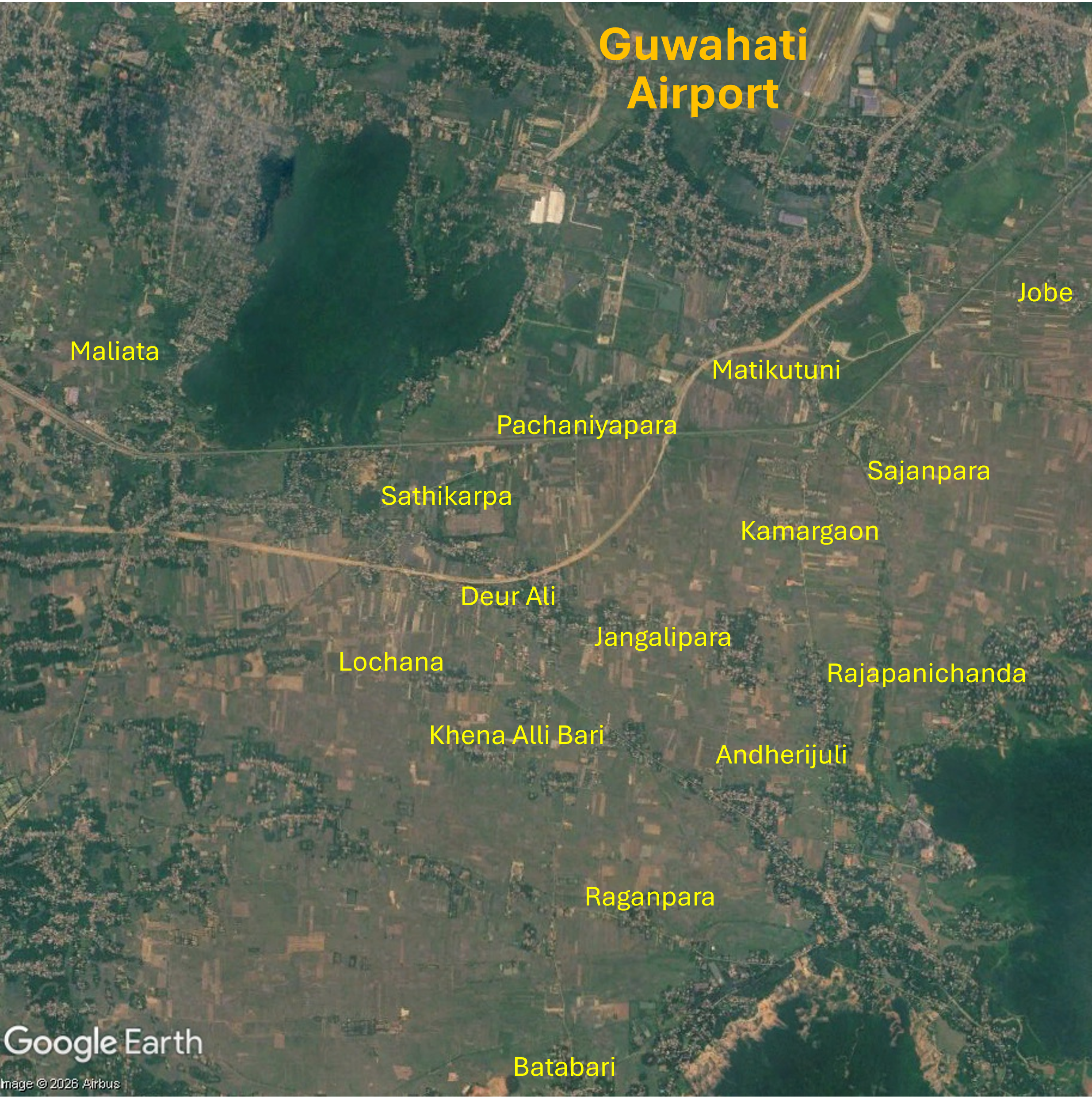
Map showing fifteen of the villages south of Guwahati Airport where it has been reported that residents have concerns about possible land acquisition and eviction for the proposed Guwahati Aero City and Satellite Township projects. Satellite imagery: 03/06/2026
On 26th June 2026 The Assam Tribune reported that residents of 16 villages in the Azara and Palasbari sub-districts, to the south of Guwahati Airport, feared eviction due to land acquisition for a proposed Aero City and a Satellite Township. No official eviction orders had been issued but residents of 16 villages – Andherijuli, Batibari, Deur Ali, Jobe, Jangalipara, Kachari Allibari, Kamargaon, Lochana, Matifuturi, Maliyata, Pachaniyapara, Patgaon, Rajapanichanda, Rangapara, Sajjanpara and Sathikarpa – were worried that land acquisition might be impending as revenue department activities had increased. There were reports that notifications for valuation and acquisition of agricultural land had been issued in six of these villages – Deur Ali, Jangalipara, Jobe, Kamargaon, Matifuturi and Pachaniyapara – where officials were collecting land-related documents. Farming is the only source of livelihood for many affected people and they were uncertain about provision of rehabilitation if their land was acquired. Tribal organisations voiced concerns that placing tribal areas under Guwahati Metropolitan Development Authority (GMDA) control might erode indigenous communities’ land rights, administrative autonomy, constitutional safeguards and the powers of the Rabha Hasong Autonomous Council. A number of tribal organisations including Rani Regional Tribal Sangha, Rani Regional All Bodo Students’ Union and Rani Regional Rabha Students’ Union submitted a memorandum to Chief Minister Himanta Biswa Sarma calling on the government to protect the rights and interests of indigenous communities in the proposed project area. A total of approximately 6,662 bighas of land had been earmarked for the two projects, about 2,662 bighas for the Aero City and the reminder for a Satellite Township.
More than 100,000 people fear displacement
Northeast Now reported that more than 1 lakh (100,000) people feared displacement for the proposed Aero City and Satellite Township. Land acquisition raised concerns in six villages inhabited mainly by Bodos, Rabhas, and Koch Rajbongshis people. Official GMDA Chief Executive Officer communication with the Special Chief Secretary of the Housing and Urban Affairs Department explained that the proposed acquisition encompassed 712 bighas in Kamargaon, 676 bighas in Deorali, 553 bighas in Pachaniara, 280 bighas in Jonglipara, 238 bighas in Matikotuni and 203 bighas in Jobe. Residents established Ucched Virodhi Bhumi Adhikar Sangram Samity (UVBASS) to oppose the proposed land acquisition and memorandums were submitted to The Chief Minister, local Member of the Legislative Assembly (MLA) and other senior officials. UVBASS president Dharmeswar Boro said, “If they go ahead with this proposal, more than one lakh people across 16 villages will be displaced” and that by planning the projects the government was “rolling out the red carpet for corporates”.
Opposition to large-scale acquisition of agricultural land
Two farmers’ organisations, Sangrami Krishak Shramik Sangha and Anti-Eviction Land Rights Struggle, held a press conference on 26th June demanding withdrawal of land acquisition processes that they claimed threatened displacement of thousands of families and destruction of fertile farmland. They said the government sought to acquire large areas of agricultural land for an Aero City, Satellite Township, Guwahati Airport expansion and other urban development projects, without providing adequate compensation or rehabilitation. The groups said about 500 families had already been evicted without fair compensation or rehabilitation and that if land acquisition plans move forward about 150,000 families might eventually be affected. They stated that nearly 2,662 bighas of agricultural land in several villages including Jobe, Jangalipara, Kamargaon, Matiya and Pachim Garal had been earmarked for acquisition. Sangrami Krishak Shramik Sangha spokesperson Dinesh Das said the government prioritised corporate interest over farmers, saying, “The government has stopped issuing treasury tax receipts and has deprived people of land rights. Instead of securing the future of farmers, it is preparing to hand over fertile agricultural land to companies for projects like Aerocity and Satellite Township. Farmers are being neglected while corporations are being favoured.” The organisations had made many appeals to the Chief Minister, Governor, Kamrup district administrations and MLA but the land acquisition process continued. The groups also raised concerns about potential impacts of the projects on wetlands and continuing conversion of agricultural land for commercial purposes adversely impacting on food production.
Protest and warning of ‘mass agitation’
On 2nd July 2026, hundreds of residents protested outside the Palasbari revenue circle office, opposing the Aero City and Satellite Township project and possible eviction. Together with families concerned they might be evicted from areas surrounding Guwahati Airport they marched along the National-Highway 17 in Mirza. Many protesters were from the Rani area mainly inhabited by Bodos and Rabhas people, where land surveys identifying non-tribal residents were underway. UVBASS sent a memorandum outlining their concerns over reports of GMDA preparing development of new townships in 17 villages to the Chief Minister. The memoranrum stated, “The primary livelihood of lakhs of people in this vast region is agricultural and animal husbandry. The construction of a ‘township’ will bring a severe crisis to the life and livelihood of this huge number of poor people.” Sangrami Krishak Shramik Sangha spokesperson Dinesh Das alleged that evictions were planned in Khena Alibari village where many residents do not have the official documentation required to live in legally protected tribal areas. He demanded protection and provision of land ownership certificates for the approximately 300 Hindu and Muslim families living in the village. The memorandum also raised concerns about land surveys underway in Parli and Majirgaon, north of Guwahati Airport and close to the newly inaugurated second terminal.
At a Nikhi Rabha Jatha Parishad (NRJP) press conference in Guwahati president Babul Chandra Rabha and general secretary Gobinda Rabha said the Assam government was pursuing major land acquisition without consulting the Rabha Hasong Autonomous Council, Gram Sabhas or local residents. The organisation said the Aerocity and Township projects entailed acquisition of agricultural and forest areas along with ancestral settlements, violating constitutional, legal and land rights of indigenous communities, placing the livelihoods and culture of thousands of families relying on agricultural, fishing, husbandry and forest resources at risk. NRJP demanded immediate cancellation of the Aerocity and Satellite Township projects, publication of the environmental and social impact assessment reports for the Ukiam River Dam project which would significantly impact agriculture and fisheries and withdrawal of another proposed Satellite Township, Barduar Bagan, south of the area earmarked for the Aerocity. NRJP warned that, should the government fail to hold discussions with local communities and the Rabha Hasong Autonomous Council, it would initiate mass agitation against the projects, in collaboration with other organisations such as Sangrami Krishak-Shramik Sangha and the Anti-Eviction Land Rights Struggle Committee.
Regulation and financing for the Aero City
Development of regulation and financing to support Guwahati Aerocity and other urban development proceeded quickly. Formation of the Guwahati Satellite Cities Development Authority (GSCDA) a government-owned Special Purpose Vehicle tasked with planning, financing and developing various types of satellite townships within the jurisdiction of the GMDA was approved by the Assam Cabinet on 13th June 2026. Times of India reported that the Guwahati Satellite City Development Authority Bill, 2026 was tabled on 9th July in the face of opposition from many groups in the outskirts of Guwahati. The Bill seeks to grant the authority ‘powers to develop integrated townships, knowledge cities, aviation cities, logistics hubs, tourism zones, economic corridors, commercial centres and other planned urban projects within notified Satellite City Development Areas or areas under its jurisdiction’. Presenting the Budget on 10th July 2026 Assam Finance Minister Jayanta Mallabaruah unveiled plans for what is presumably another name for the Aero City project, an ‘Aerotropolis’ with industrial and commercial districts around Guwahati Airport, to be implemented by the GSCDA. The Budget allocated ₹2,100 crore (USD220 million) for land acquisition for the projects.
Adani prioritises airport city development
The operator of Guwahati Airport, Adani Airport Holdings (AAHL) – India’s largest private airport operator and a subsidiary of Adani Enterprises Ltd. (AEL), one of India’s largest multinational conglomerates – has adjusted its strategy and corporate structures to prioritise airport city development. In December 2025 Adani announced a shift in focus to prioritisation of urban development at its airports, integrating aviation with real estate and diversification of revenue streams. A key element of this strategy is development of airports, in cities including Guwahati, into urban destinations with retail, hospitality, entertainment venues and office space plus a new emphasis on development of in-house hotels. A key driver of Adani’s focus on city-side development is the higher yields, often exceeding 20%, from non-aeronautical revenue streams – such as retail food and beverages – than the typical yield of about 12% from aeronautical sources including landing and passenger service fees. On 6th April 2026, AEL established three wholly owned subsidiaries for real estate activities on land parcels surrounding its hub airports: Adani Navi Mumbai Airport City Limited (ANMACL), Adani Guwahati Airport City Limited (AGACL), and Adani Ahmedabad Airport City Limited (AAACL). These subsidiaries will focus on development and leasing of buildings and management of hotels, restaurants and business centres. On 25th June 2026 AAHL subsidiary Adani Airport City Limted (AACL) announced plans for the first phase of an ‘ambitious programme to develop integrated airport cities across its airport network’. A Rs 20,000 crore (USD2.07 billion) investment aims to transform six airports – Mumbai, Navi Mumbai, Ahmedabad, Lucknow, Jaipur and Guwahati – into ‘mixed-use urban destinations’ with hotels, offices, shopping and dining outlets, entertainment venues and convention centres.
Aerotropolis land acquisition notice in 2025
Opposition to a proposed Aerotropolis near Guwahati Airport dates back to 25th July 2025 when a land acquisition notice encompassing 400 bighas of land in Azara, Garal and Mirzapur, north and northeast of the airport, met with anxiety, anger and opposition from many affected residents. More than a thousand families feared loss of their homes and livelihoods. In Garal village critics of the project claimed the land acquisition process lacked transparency, consultation or a clear plan to rehabilitate affected people and that the main beneficiary would be a private company. Affected families began to protest the land acquisition process, demanding transparency, thorough impact assessment and rehabilitation guarantees. Leader of the Opposition Debabrata Saikia described the move to acquire land for the Aerocity as anti-indigenous and serving corporate interests, saying that more than 1,116 families had received eviction notices, some of whom had held land titles for nearly 200 years. Villagers attending a public meeting in Mirzapur unanimously resolved not to give their land to the government under any circumstances, declaring, “Our land is our identity and livelihood. We will not give it away at any cost.” At this stage of the Aerotropolis residents were already concerned that development of the project might eventually require an area as large as 6,000 bighas, triggering further land acquisition.
For more information including references for all source material and photos see the case report on EJAtlas, the world’s largest, most comprehensive online database of social conflict around environmental issues – Guwahati Airport expansion and Aerotropolis, Assam, India
A plan for an ‘eco-luxury and tourism project’ encompassing nearly half of Bugsuk Island is the latest of a series of projects triggering a 50-year struggle for recognition of ancestral land and water rights.
Satellite imagery of Bugsuk Island, Balabac municipality, Palawan province, 27th October 2024. Bugsuk Airport and other facilites are indicated.
In 1974 indigenous Pala’wan, Molbog and Cagayanin people were expelled from Bugsuk Island, part of the Balabac Municipality off the southern tip of Palawan, the westernmost point in the Philippines. An article by Indigenous Peoples’ Rights International (IPRI), based on an interview with Jomly Callon, President of the Sambilog-Balik Bugsuk Movement (Association of Indigenous Peoples and Small Fishers from the Southernmost Tip of Palawan), an indigenous people’s group, outlines a 50-year history marked by projects, facilitated by a series of policy decisions, taking the place of agricultural and fishing livelihoods. The land was awarded to Danding Cojuangco, Chief Executive of San Miguel Corporation (SMC), one of the Philippines’ largest business and industrial conglomerates, who established a nursery for hybrid coconut trees. In 1979 Cojuangco, in partnership with a French businessman, Jacques Branellec, formed the Jewelmer International Corporation which established a pearl farm in ancestral waters. Sambilog was formed in the year 2000 in response to land grabbing and reducing access to fishing grounds, working to gain recognition of ancestral land and water rights. They made an application for a Certificate of Ancestral Domain Title (CADT) which has still not been approved by the government. Indigenous people’s access to traditional fishing grounds was eroded further in 2005 when, without consulting indigenous people, the Balabac municipality was declared a ‘protected marine eco-region’, prohibiting indigenous people from fishing in their traditional fishing grounds. In 2014, following Sambilog protests in Manila calling for return of their lands through the Comprehensive Agrarian Reform Program Extension with Reforms (CARPER) the Department of Agrarian Reform (DAR) issued a Notice of Coverage over agricultural lands for distribution to the people of Bugsuk Island. But DAR did not implement its decision to return the land to those affected by displacement.
After Cojuangco’s death in 2020 Ramon Ang took up the role of CEO of SMC. Bugsuk Airport (also referred to as Bonbon Airport) was built by SMC to support the coconut plantation. In February 2022 Jose Alvarez, Governor of Palawan, speaking about Bugsuk Airport and a Philippine Air Force (PAF) facility in Barangay Catagupan being ‘crucial to the transformation of Palawan’s southernmost region as a new tourist haven‘, said the coconut plantation had failed but that Bugsuk Airport was still under development with the runway already operational and used by people travelling to Balabac. Satellite imagery of Bugsuk island shows Bugsuk Airport, an airstrip near the southern tip of the island that is being developed for the PAF and a helipad. In 2023 the DAR revoked the Notice of Coverage that was issued in 2014 and under which the land would be returned to its original owners. The reason given for the cancellation was that the area is unsuitable for agriculture. Callon, countered this, explaining that residents were cultivating the land, growing many types of vegetables and fruit trees.
Environmental Impact Statement and Master Plan for resort taking up half the island
Bricktree Properties Inc., a subsidiary of SMC, plans to construct various so-called ‘eco’ tourism facilities surrounding Bugsuk Airport. Bricktree’s presentation at a public scoping event held in Bugsuk Community Center, Bugsuk Island on 25th May 2023 contains a timeframe for 2023-24 which includes access road clearing and construction, tree cutting, land clearing, construction of campsites, perimeter fencing and soil compaction. A number of ‘identified environmental impacts’ includes ‘Land tenurial issues and incompatibility with existing land use’, ‘Potential lost (sic) of fish related livelihood and conflict on the access/navigation of locals’ along with potential changes in water quality, water competition and dust from land clearance. The Environmental Impact Statement Summary for the Proposed Bugsuk Island Eco-Tourism Development Project, prepared for Bricktree, contains maps of the proposed site and a Proposed Master Plan comprising serveral zones taking up much of the south of the island along with a port on the northern tip.
The Environmental Impact Statement Summary states ‘The Proposed Project aims to be an eco-luxury leisure and tourism destination governed by sustainable development principles’. A project schedule from 2023 to 2038 is indicated. The project location spans two barangays (districts) – Bugsuk and Sebaring – and the estimated total project land area is 5,567.54 hectares (nearly half of the 11,900 hectare island). Supporting infrastructure plans include power generator, solar farm, water supply primarily from Bugsuk River Lagoon, wastewater and sewage management, telecommunications, materials recovery facility, landfill and beach front maintenance on the Bonbon beach shoreline. The area earmarked for structures, roads and other facilities is 1,141.84 hectares, with the remaining 4.425.7 hectares consisting of areas for future development, open spaces and leasable space. A map of the Proposed Master Plan shows various zones centred around the airport and airport facilities and connected by a road network:
Eco-tourism area immediately to the south of the airport
Resort development on the southeast coast
Two forest / tourism areas
Four commercial areas
Low density and high density residential areas
Recreation area
Light industrial area
Employee facilities
Agriculture zone
An area for port facilities on the northern tip of the island
Tinig ng Plaridel, the official student publication of the University of the Philippines College of Mass Communication, challenged the statement in the document that resolutions endorsing the proposed project without objections were obtained from Barangay Bugsuk in September 2023, saying that hundreds of locals oppose the project.
Intimidation and harassment of Mariahangin residents
During the 1974 expulsion of indigenous people from Bugsuk Island the people of Mariahangin (also spelled Marihangin), a small 38 hectare island north of Bugsuk Island, resisted; the eviction was stopped and people remained on the island. But 50 years later Mariahangin residents say the presence of armed men is pressurising them to leave. On 27th June 2024 DAR officials arrived on Mariahangin, to inform residents that their homes would be demolished to make way for an eco-luxury tourism project covering over 5,000 hectares in Barangay Bugsuk. Just two days later, early in the morning of 29th June 2024 16 unidentified armed guards arrived on Mariahangin Island. On 13th September a group of indigenous people from Mariahangin Island arrived in Manila to campaign for land reform, the return of the 10,821 hectares of land awarded to Cojuangco in 1974, for the National Commission on Indigenous Peoples to process their CADT application and to raise awareness of the 50-year struggle. The group included an 18-year old witness to the presence of armed men in Mariahangin in June who said a man wearing black headgear and a black mask had pointed a gun at him.
Satellite imagery of Mariahangin Island, 27th October 2024
SMC denied involvement in the shooting incident and stated it has no connection with anyone involved in the incident and does not own any property holdings on Mariahangin Island. Yet, as reported by Bulatlat, residents claim that SMC does have an interest in Mariahangin Island and, in 2023, presented families with a ‘resettlement programme’, increasing an initial offer to P400,000 (USD6,852) per family to leave their ancestral land. In September 2024 the Philippine Misereor Partnership Incorporated (PMPI), a network of more than 230 social development and advocacy groups, expressed deep concern over human rights violations faced by the Molbog and Palaw’an communities arising from a land grabbing case. Mariahangin residents’ representatives, supported by the National Federation of Peasant Organisations (PAKISAMA) presented testimonies to the Commission on Human Rights (CHR) reporting reported ‘alarming incidents, including threats at gunpoint to force them out of their ancestral lands and intrusive surveillance and intimidation that profoundly disrupt their daily lives and livelihoods’.
On 2nd December 2024, contradicting Bugsuk residents’ assertion of their land rights, SMC reiterated its stated legal ownership of 7,000 hectares of titled properties on Bugsuk Island, saying that the titles had been held since original issuance during redistribution of agricultural land in 1974, predating the 1997 Indigenous People’s Rights Act. Earlier that day, nine indigenous Sambilog leaders began a nine-day fasting and praying event outside the DAR headquarters in Quezon City to amplify the 50 year land struggle of indigenous Bugsuk Island communities. They pointed out that Mariahangin land is agricultural – seaweed farming is the main source of residents’ livelihoods, followed by corn cultivation – so therefore the land should be returned to them under the provisions of the 1998 Comprehensive Agrarian Reform Law which states that all public and private agricultural lands are encompassed by the coverage for distribution to the people. An ILC Asia (International Land Coalition) statement in support of the seaweed farmers of Mariahangin Island raises concerns over loss of mangroves in a country particularly vulnerable to climate disasters and notes that mangroves on Bugsuk Island have already been cleared to make way for a 20km white sand beach.
In February 2025 Mariahangin residents refuted government dismissal of their allegations of harassment, land grabbing and restriction of access to fishing grounds. Residents said police and people suspected of being SMC representatives attempted to enter the community on 18th and 20th November and that armed guards had been stationed about 500-500 metres from Mariahangin. One resident said, “People there can barely earn a living because they’re constantly guarding against those armed men at the edge of the island.” Residents guarding the area reported threats from armed guards. Fishermen said guards were blocking access, seizing their equipment nad harassing them, with some being hit with paddles and illegally detained. One fisherman said his boat had been destroyed. On 5th March 2025 The Guidon reported that eight Mariahangin residents had been subpoenaed over allegations of assault and an individual received a subpoena for alleged cyberlibel. residents described these legal proceedings as part of “a pattern of relentless harassment” amidst their long-running land dispute with SMC over ancestral land on Bugsuk Island.
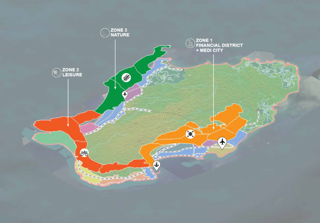
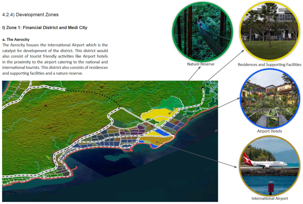
Airport development features heavily in a plan for tourism-oriented megaprojects on Little Andaman Island, the southernmost island of the Andaman archipelago. Graphics below, from the 58-page ‘Sustainable Development of Little Andaman Island – Vision Document’, show: Zone 1, on the eastern coast, featuring an Aerocity, housing an international airport, envisaged as ‘the catalyst for development of the district’; Zone 2, on the southern coast, including a Leisure Zone and Tourism SEZ (special economic zone) with casinos, theme park and beach hotels; Zone 3, on the western coast, a Nature Zone containing super-luxury resorts and hotels, with an airstrip for private charter flights.
Map of Little Andaman plan indicating developable areas
Little Andaman plan map showing 3 zones
Zone 1: The Aerocity is the catalyst for development
Sudden news of the plan, in January 2021, alarmed conservationists. The ‘Vision Document’, thought to have been finalised a few months previously but not in the public domain, is included in ‘A MONUMENTAL FOLLY: NITI Aayog’s Development Plans for Great Nicobar Island (An evolving archive of reports, information and documents)’, compiled by Panjaj Sekhsaria and published by Kalvpavriksh Environmental Action Group. The total project area is nearly 240 sq km, 35% of the island; the three zones would take up 107 kilometres of the island’s coastline. Development of this scale would have major impacts on indigenous people and the island’s unique biodiversity and forests. Little Andaman is home to the Onge tribe, living on the island for more than 50,000 years, the population dwindling since 1900. Now numbering an estimated 125 people the Onge tribe is categorised as one of India’s Particularly Vulnerable Tribal Groups (PVTG). According to the plan the Onge Tribal Reserve would be reduced by 31%; the Vision Document states that steps would be taken to relocate and protect Onge people but no detail is given. An anthropologist pointed out that bringing areas where Onge, with nomadic origins, do not live into the proposed development would still impact them, saying “the Onges have a close attachment with their territory be it inhabited or not”.
The Divisional Forest Officer of Little Andaman raised concerns that the major diversion of forest land for the project would cause irreversible damage to the island’s forests, entailing the loss of more than 2 million trees. An official source said there are over 2.4 million trees in the “vast tract of forests” in the areas where development is proposed. Removal of trees would cause topsoil erosion and reduce rainfall, impacting on the small area of the island with cultivable soil. Uprooting more than 2 million trees for the Little Andaman plan would also result in carbon emissions and carbon stock losses. Carbon pools were calculated for the four forest types in the development areas: nearly 136 sq km of Evergreen/Semi Evergreen and smaller areas of Deciduous, Swamp/Mangrove and Plantation forests. A study estimated that implementation of the ‘Sustainable Development of Little Andaman – Vision Document’ would result in carbon stock loss of 2,996.286 tonnes from five categories of carbon pools: 55% from woody debris and soil organic matter, 32% from above ground living biomass, 9% from below ground biomass, 3% from dead mass of litter and 1% from dead wood.
Nesting sites of Giant Leatherback Turtles, the world’s largest turtles growing over 6 feet in length, with many populations in precipitous decline, are threatened by the Little Andaman plan. South Bay and West Bay on Little Andaman are both high-intensity nesting sites and among the most important in the entire island chain. Along with other nesting beaches on the islands, the two sites are specifically mentioned as ‘Important Marine Turtles Habitats in India’ in the National Marine Turtle Action Plan. There are fears that implementation of the ‘vision’ would push the leatherback turtles to the brink of extinction. A 2019 report on a long-term monitoring programme at Little Andaman island identified previously unknown migratory routes of Great Leatherback Turtle nesting in the region, highlighting their dependence upon foraging and nesting sites that are thousands of kilometres apart. Nine tracked turtles traversed much of the Indian Ocean, as far southeast as Western Australia and towards the eastern coast of Africa. The turtle travelling the furthest, close to the western coast of Mozambique, covered 13,237km in 266 days; it was also the fastest, travelling an average of 49.8km per day.
More information about the Little Andaman plan has been published on EJatlas, the world’s largest, most comprehensive online database of social conflict around environmental issues: Little Andaman Development Plan
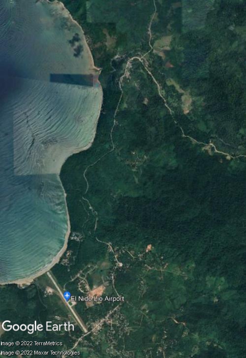
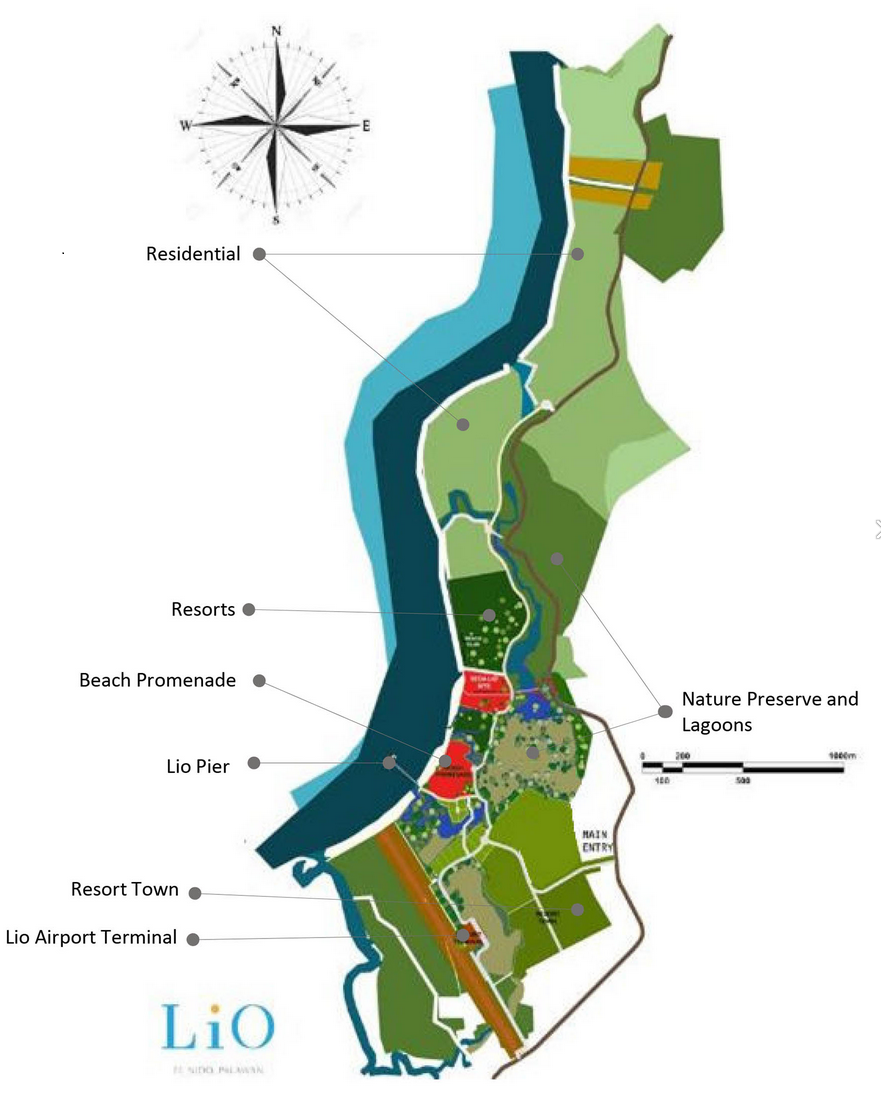
Lio Tourism Estate, a masterplanned luxurious development in El Nido, on the northern tip of Palawan – owned by Ayala, one of the largest conglomerates in the Philippines, and operated by one of its many subsidiaries, Ten Knots Philippines Inc. (TKPI) – encompasses a large 325-hectare site. As well as high-end hotels the resort contains its own private airport, Lio Airport, owned and operated by TKPI for the exclusive use of its aircraft. As with most airports worldwide the response to Covid-19 led to Lio Airport reducing operations, but by March 2022 about 600 passengers were flying in and out each day. AirSwift Philippines operates flights between Lio Airport and Manila. There is also a jetty port for visitors to embark on island-hopping boat trips. The tourism project, on a former copra (coconut) farm, began with construction of the airport and seaport to provide access, followed by accommodation and retail facilities. Shown below are satellite imagery and a site development plan published by a property firm.
But the Tagbanua Tandulanen Indigenous People (IP) claim that the project encroaches on their ancestral lands. In April 2021 their attorneys requested that the Department of Tourism (DOT) and Local Government Unit of El Nido cancel, revoke or deny applications for building permits and licenses for more than seven Ayala-owned businesses and projects in El Nido, including Lio Tourism Estate and Lio Airport. The IP group claimed ‘rampant and widespread’ proliferation of illegal transfers and conversion of their ancestral domain. On 15th March 2022, following reports of projects and activities that did not comply with Free and Prior Informed Consent (FPIC) requirements, the National Commission on Indigenous Peoples (NCIP) intervened in the land dispute, issuing a cease-and-desist-order (CDO) ordering temporary halt of projects in Barangays Libertad and Pasadeña. After issuing four notices to comply with the CDO NCIP issued a show cause order to TKPI on 13th February 2022. In March Tagbanua Tandulanen IP’s legal counsel said the group been sending letters to TKPI for two years without receiving a serious response and urged NCIP to maintain the CDO.
Extending northwards of the tourism estate developed area and Lio Airport is a 4.2 kilometre stretch of white sand beach, also part of the resort. In September 2017 the management of Lio Tourism Estate dismissed accusations that its recently opened upscale resort had blocked access to the public beach in front of it for residents of Barangay Villa Libertad. The issue stemmed from a complaint to the Palawan Provincial Board’s Environment Committee. A month previously Board Member Winston Arzaga said they had been asked by local officials to help resolve the issue, saying “The cause of it all is the access of local fishermen to their traditional fishing grounds which the Ayala management had somehow restricted.” A Safeguards Due Diligence Report for El Nido tourism development, prepared by the Tourism Infrastructure and Economic Zone Authority (TIEZA) for the Asian Development Bank (ADB), published in May 2021, includes notes of a consultation on fisheries management concerns and livelihood projects with Barangay Officials of Villa Libertad, which covers Lio beach, part of Lio Tourism Estate. Dwindling fish catch was the major fisheries issue identified by informants, resulting from overfishing and a reduced fishing area. Declining fish catch and reduced access to fishing grounds was also mentioned in relation to three other Ayala resorts in El Nido, on the islands of Miniloc, Pangulasian and Lagen.
More information about the land dispute and issues with access to fishing grounds related to Lio Tourism Estate and Lio Airport has been published on EJatlas, the world’s largest, most comprehensive online database of social conflict around environmental issues: Lio Tourism Estate and Lio Airport
Indigenous communities are protesting the expansion of Suriname’s international airport. The airport has obtained title to the neighbouring, indigenous land, and wants to expell most of the population of the Arawak villages Hollandse Kamp and Witsanti. Indigenous people reject the airport’s claim that they are the trespassers. They also protest against the airport’s dumping of untreated sewage into waterways that run through the two neigbouing Arawak villages.
Despite 500+ years of resistance, Indigenous people in Suriname are still not recognised as land owners. Suriname law doesn’t recognise collective land ownership at all. The state owns all land which is not individually owned. The government recently transfered ownership of the two indigenous villages to the state-owned International Airport of Suriname, without any consultation with the indigenous people who have lived there for generations.
For more information, contact http://www.vids.sr/
Press conference of chiefs, Hollandse Kamp, Suriname, 16 October 2015