Residents of Radwaniyah, an agricultural area south of Baghdad International Airport, protested allocation of a large land area for Baghdad Financial and Economic City, also referred to a Al-Rafeel City, demanding a halt to planning and construction activities and a comprehensive audit of the investment contract.
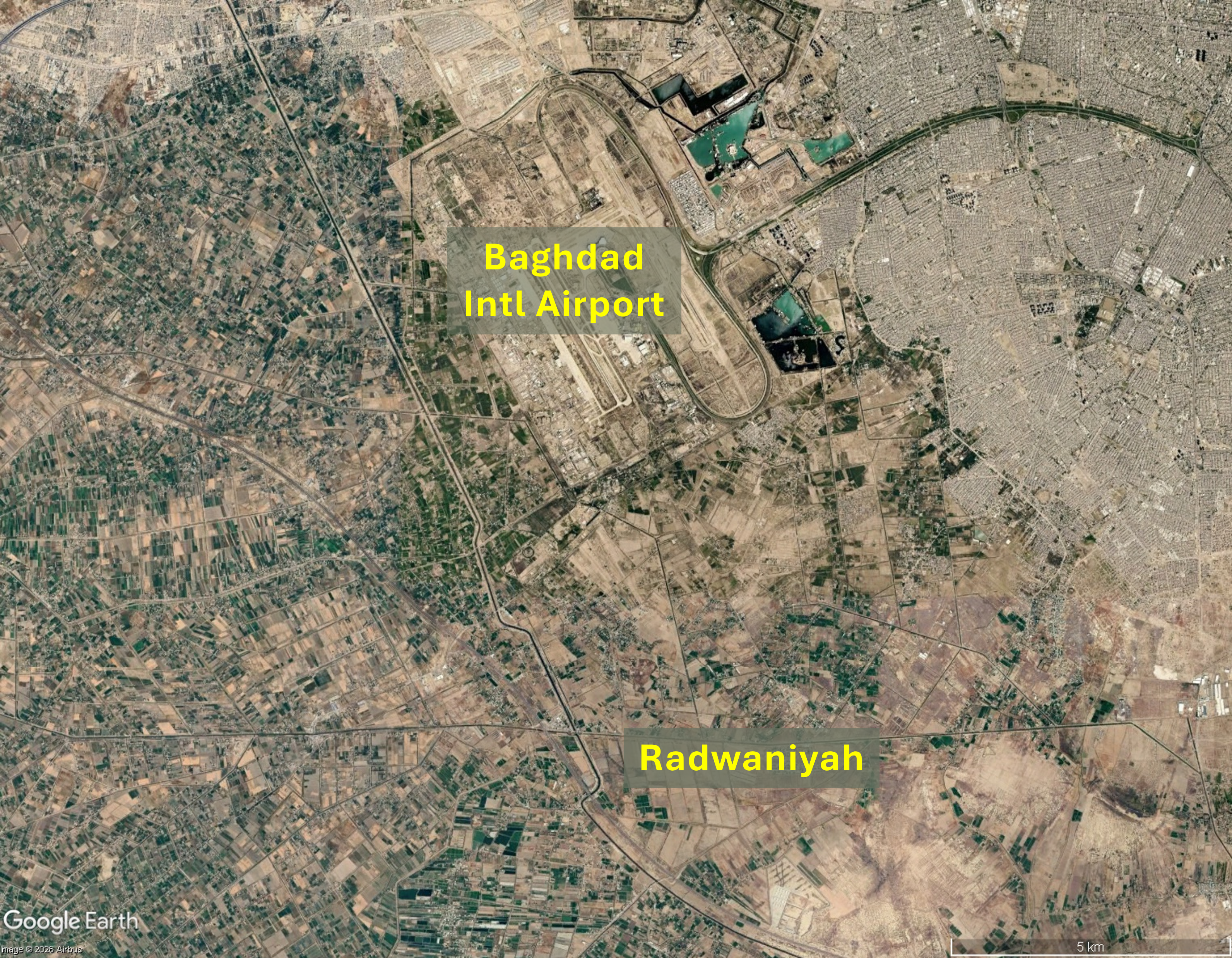
On 30th May 2026 a major protest erupted in the Radwaniyah district, an agricultural area south of Baghdad International Airport, over government plans to hand over large areas of land surrounding the airport to foreign firms. Local residents and community leaders gathered to issue an urgent call for protection of their property rights and ancestral territories from corporate appropriation. The area allocated for development encompasses land belonging to families who have lived on it for many generations. Ayad al-Jubouri, a Member of Parliament, called on Prime Minister Ali Falih al-Zaidi to suspend the investment licence and stop an administrative decree that could lead to forcible displacement of more than 120,000 residents. He said local residents would “prefer death over surrendering their lands”. Protesters demanded a halt to planning and construction activities until verification of the investment contract by a comprehensive legal and administrative audit. The protest followed several critical statements by al-Jubouri, most recently alleging serious corruption orchestrated by the National Investment Commission (NIC) which, he said, had granted an investment licence to an Egyptian firm, giving the developer more than 580 hectares of valuable Radwaniyah real estate for construction of Al-Rafeel, a large residential project.
TMG investment contract and land bank
The day after the protest, 1st June, one of Egypt’s largest real estate development companies, Talaat Moustafa Group Holding (TMG), announced receipt of an investment licence from the NIC for its subsidiary Talaat Moustafa Company Baghdad for development of an ‘integrated urban community’ southwest of Baghdad. TMG also secured a large land bank of 1,280 hectares for the project, ‘strategically located within Baghdad Financial and Economic city’ with direct connectivity to key administrative and financial districts. Infrastructure costs are to be met by investors who are expected to reap significant returns. The project is anticipated to generate about $18.8 billion in sales and annual revenues of approximately $108 million from leasing and hospitality upon completion of the 16-year development period. In addition to approximately 43,000 residential units to accommodate 250,000 residents the project master plan includes about 230 hectares of retail and commercial assets including a ‘regional mall’, offices, administrative space, religious and civic facilities, sports and social club, entertainment venues, parks and green space. Company headquarters, offices and large warehouses will be relocated from central Baghdad, one of the most heavily congested cities in the Middle East, to the new city.
Land ownership and MoU
In the days preceding the protest the NIC emphasised the legitimacy of the new financial and economic city, stating that the project is part of the urban planning framework and consistent with the Baghdad 2030 Comprehensive Development Plan. The NIC stated that the land is government-owned, by the Ministry of Transport and Ministry of Finance and that occupation of the Ministry of Transport land ‘constitutes an unlawful encroachment’ while the Ministry of Finance Land had been transferred to the NIC. Agricultural contracts on the land were declared legally void on the basis that plots had been converted to commercial purposes, The NIC also stated that the Ministry of Resources had confirmed that continued zoning as agricultural land would be unworkable as there is no existing or planned allocation of water for the land designated for the new city. Six months previously, in November 2025 a TMG delegation led by Chairman Hisham Talaat Moustafa had met with then Prime Minster Mohammed Shia Al-Sudani for discussions focused on Al-Rafeel Economic City. Moustafa reviewed progress on the project and affirmed TMG’s commitment to advancing it in accordance with the implementation framework. A memorandum of understanding (MoU) for Al-Rafeel Economic City between TMG and the NIC was signed in May 2025 and the agreement includes participation from Saudi Arabia-based Al Muhaidib Group, one of the largest investment groups in the Middle East. The MoU signing ceremony was attended by Mohammed Al Sudani, Hisham Talaat Moustafa and NIC Chairman Haider Makiya and Al-Muhaidib Group.Chairman Suleiman bin Abdul Qader. At this juncture the project was described as spanning 1,400 hectares with about 46,000 residential and mixed-use units.
Land allocation in 2021, forced evictions in 2019
The Council of Ministers approved allocation of 106,000 acres (42,897 hectares) of land in the area surrounding Baghdad Intl. Airport to the NIC to oversee construction of the ‘Al-Rafael’ city project on 15th June 2021, envisaging a new administrative capital similar to counterparts in some neighbouring countries. NIC Chairwoman Suha Daoud Najjar outlined four phases of development, the first providing housing for 300,000 people along with commercial, educational, medical and recreational complexes on 16,000 acres (6,475 hectares). Plans for the second phase included industrial and logistics projects adjacent to the airport and third phase plans were described as ‘environmentally friendly agricultural and food projects’. A fourth phase would be located northwest of the airport in the Abu Ghraib district. Evictions from land surrounding Baghdad Intl. Airport pre-date the 2021 announcement of Al Rafeel city. In July 2019 Euro-Mediterranean Human Rights Monitor condemned the seizure of thousands of acres of land near the airport for UAE-based commercial and real estate investment firm Daico International Holdings and other investment firms, following orders issued by the NIC. The report stated that the eviction and forced displacement without compensation violated Article One of the Iraqi Constitution, which safeguards private property and of Article Two which affirms that expropriation is only permitted if it is in the public interest and people are fairly compensated. People affected by the land seizure included a man from eastern Radwaniyah who was told to vacate his 20 acres of land for a businessman said to be close to NIC. Fear of retaliation, in the form of forced displacement or imprisonment, deterred him from taking his grievance to court.
.