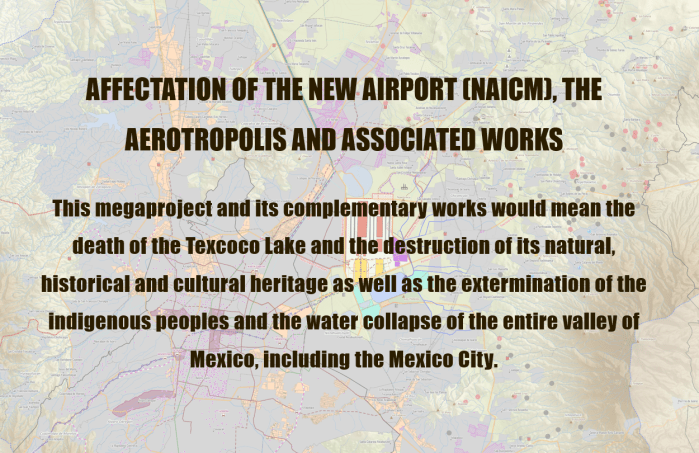
GAAM is delighted to share an incredibly informative set of maps elucidating the complex socio-economic and environmental impacts of construction of New Mexico City International Airport (NAICM). The maps were produced by GeoComunes, a collective working with communities to use maps as an analytical tool to strengthen the struggle for defence of common goods, in collaboration with affected residents and NGOs supported by Coordinadora de Pueblos y Organizaciones del Oriente del Estado de México (CPOOEM), which supports people’s defence of land, water and culture in eastern Mexico. The NAICM site, covering over 4,431 hectares, is the waterlogged Texcoco lakebed. Aerotropolis development is planned: a specific area within the airport site and commercial and industrial development over an extensive area surrounding it.
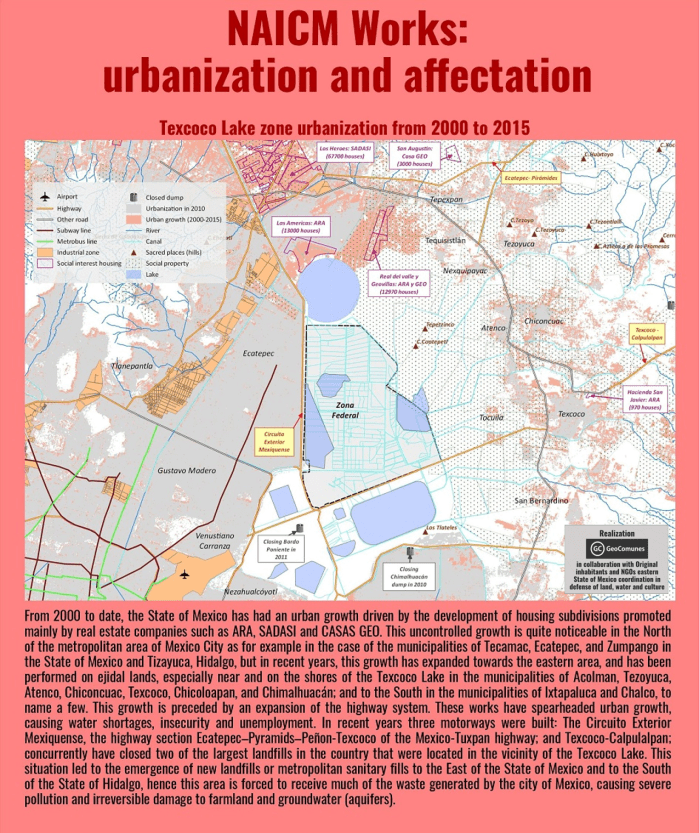
The first map, below, shows uncontrolled urbanization between 2000 and 2015, preceded by highway expansion, driven by real estate and encroaching on ejidos (communally held agricultural land) near the shores of Texcoco Lake. Landfill sites receiving waste from Mexico City have damaged farmland and polluted aquifers. The airport site is in the ‘Zona Federal’ area in the centre of the map. The existing Mexico City International Airport (officially named Benito Juárez International Airport) is shown near the bottom of the map.
A perimeter fence has been erected around the NAICM Phase 1 project area. The site includes ejidal lands, in spite of assurances that the airport would be built entirely on federally-owned land. Ejidal lands were also appropriated for a highway and housing developments, and many Ejidos (land holders) were violently evicted by state security forces. Plans for Aerotropolis phase 1 include a shopping mall, hotels, industrial park, exclusive high-end housing, golf courses and a free trade zone.
The third map shows satellite imagery of the three Ejido areas directly affected by airport construction. Over 330 hectares of ejidal lands, in the communities of Ixtapan, Nexquipayac and Atenco, were seized from its rightful owners by the government and now lie within the NAICM perimeter fence.
Land-levelling to prepare the site for construction of the airport involved clearing saline sludge from the lakebed and toxic waste that has been dumped, polluting the Texcoco aquifer and damaging farmland. Extraction of materials for use in has had a devastating impact on sacred mountains, in the Valley of Mexico. Blasting with dynamite has damaged, forests, biodiversity, springs and archaeological remains. It is estimated that 64 million tonnes of tezontle (red volcanic rock) along with stone and other materials, carried on 400 trucks per day, will be deposited to fill in the Texcoco lakebed.
Water drained from the Lake Texcoco area will be channelled into Nabo Carrillo, an artificial lake and newly created lagoons, along with water from the area east of the airport site channelled via several culverted rivers. Lying at the bottom of a downward slope the airport site is at risk of flooding from concentration of water flow in this area. The flood risk could become more severe as Texcoco lakebed is sinking at a rate of about 12 inches annually.
An extensive road network linking NAICM to key urban centres is planned and under construction, encroaching on ejidal land and opening up additional land for real estate and commercial development. Many of the roads are toll roads which will generate profits for construction firms holding the concessions and thus set to benefit from the traffic flow.
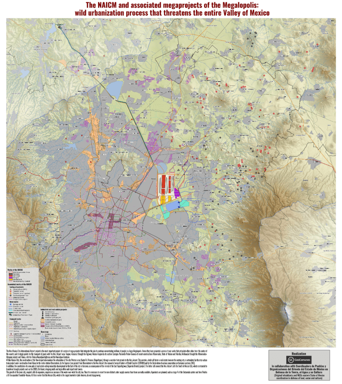
Data from all the maps is combined in the final map, which covers a wider geographical area revealing the extent of the urbanization that is underway and planned. See the larger version of the map for more detail. NAICM is shown within a wider context as the most important of, and the focal point for, a series of megaprojects combining to form a ‘Megalopolis’, an agglomeration of cities and other urban areas. New road and rail corridors will foster further real estate development. Mexico City already suffers chronic water shortages and springs and groundwater are over-exploited. The current model of urbanization will increase stress on water supplies and aqueducts are planned to access more distant sources.
All the maps of NAICM and aerotropolis plans can be seen here in their entirety and are best viewed on the largest computer screen that you can find so you can zoom in and see the intricate detail.
Approval of plans for Bulacan Aerotropolis in Manila Bay, one of the biggest megaprojects in the Philippines, threatens 700 families with displacement and loss of their fishing livelihoods. Thousands more fisherfolk would be affected by land reclamation for the 2,500 hectare airport and ‘airport city’ complex.
On 25th April the National Economic and Development Authority (NEDA) of the Philippines approved plans for a new airport and metropolis, i.e. an aerotropolis, in Bulacan province, Manila Bay. Residents of the village of Taliptip and seven other areas will be affected by the project and at least 700 families face displacement. They make their living from selling their fishing catch in a nearby town and from making fishing nets. Their income is low but life is good and they do not want to leave. A woman who has lived in Taliptip for 43 years is worried for the future of her children and grandchildren. They were not informed about the airport plans and have been told they will be relocated, but not where, or how they might make an alternative livelihood.
Local communities resisting loss of their homes and incomes for the airport project are being supported by environmental and church groups and people can follow the local people’s struggle on the Save Taliptip Facebook page. Leon Dulce, national coordinator of the Kalikasan-People’s Network for the Environment, writes that the Bulacan aerotropolis plan is being pursued aggressively and was kept hidden from Taliptip residents until news broke of President Duterte’s approval of the project. The seas surrounding Taliptip support the livelihoods of about 5,000 fisherfolk and salt-makers, who face being displaced for the project.
Living in hardship has made Taliptip’s people resourceful, they live off the grid using solar power and batteries for their modest electricity needs. The fishing catch has dwindled but they are determined to remain in their homes maintain their established communities. A fisherman from Sitio Kinse, an island community in the midst of the mangroves along the shoreline said: “So long as the sea is here, there is hope … What will we fish if all this were turned into cement?” Fisherfolk take care of mangroves, a vital habitat for many bird species including egrets, terns, kingfishers and swallows, along with shellfish living among its roots. At the beginning of May there was a ‘massive mangrove cutting spree’ in Taliptap, reportedly undertaken by SMC, possibly without the required environmental clearance and thought to be connected with Bulacan aerotropolis. On 12th May Pinoy Weekly posted a photo of Taliptip mangroves that had been cut.
LOOK: Several trees of api-api, a species of mangrove, were cut in Brgy. Taliptip Bulakan, Bulacan. San Miguel Corp. was recently awarded by DENR an original proponent status to build a P700-B aerotropolis in Brgy. Taliptip. pic.twitter.com/aWfjsemSvi
National fisherfolk alliance Pamalakaya also opposes the new airport. Chairperson Fernanado Hicap said the project will cause environmental disaster in Manila Bay; destruction of marine ecosystems would threaten the livelihoods of more than 20,000 fisherfolk in Bulacan and neighbouring towns. Hicap also lambasted the broader Build, Build, Build (BBB) infrastructure development programme that the new airport is part of, for selling coastal waters and public lands to large developers and foreign investors. Constructing an airport in Manila Bay would require extensive land reclamation works, creating new land from the sea and wreaking destruction on fishing grounds.
Developers and governments often opt for land reclamation, as an alternative to building on farmland and obviating the loss of productive agricultural land and displacement of rural communities. But dredging up vast volumes of sediment from the ocean bed exacts a terrible ecological toll; ecosystems including mangroves, coral reefs and coastal flats are eradicated when sediment is dumped on top them. The new airport is just one of five land reclamation projects Duterte’s administration has approved in Manila Bay, described by Hicap as disregarding the “socio-economic rights of hundreds of thousands of fisherfolk and coastal settlers”. Land reclamation for the Bulacan airport project is likely to impact not just on the town of Balakan but on the neighbouring towns of Hagonoy and Paombong and the city of Malolos.
A mega-airport and a new metropolis
A mega-airport is planned, with six parallel runways and initial capacity for 100 million passengers annually, more than double the passenger throughput at the existing main Manila airport, Ninoy Aquino International Airport, the busiest in the Philippines. With a budget of P735.63 billion (US$14.2 billion) the new airport in Bulacan is the country’s most expensive transport project to date, by far the most costly of eight infrastructure projects approved as part of the Build, Build, Build (BBB) programme on 25th April by the National Economic and Development Authority (NEDA) Board, chaired by President Rodrigo Duterte.
San Miguel Corp (SMC), the Philippines’ biggest company by revenue – a conglomerate with interests spanning infrastructure, real estate, mining, petroleum, power and food & beverages – is set to build, operate and maintain Bulacan airport and aerotropolis. The plan spans 2,500 hectares, comprising 1,168 hectares allocated for the airport and 1,332 hectares for an adjoining ‘airport city’. The video below includes a graphic showing the basic layout.
SMC’s unsolicited proposal to build Bulacan Airport, revealed after scrutiny by the Department of Transportation in November 2017, featured additional SMC projects, in the form of the obligatory surface transportation network that is inherent to the aerotropolis development model. An SMC-built expressway linking the airport to the North Luzon Expressway is planned, which would in turn link to SMC-backed Metro Rail Transit Line-7. By the time NEDA approved the Bulacan airport proposal in April 2018 the expressway project specified a revenue stream for SMC, an 8.4 kilometre airport toll road. NEDA gave SMC’s proposal for Bulacan airport the green light in spite of Department of Finance concerns that the project is to be implemented by SMC subsidiary San Miguel Holdings Corp, whose capitalization is smaller than the airport project.
Clark Airport – another aerotropolis, another new metropolis
Some potential Bulacan Airport investors were cautious about the project because expansion of Clark Airport could serve similar markets. NEDA has approved US$241 million expansion of Clark Airport as another priority under Build, Build, Build. Finance Secretary Carlos Dominguez highlighted Clark Airport growth at an Asian Development Bank briefing saying “Clark will will soon be the showcase of the Duterte administration’s economic strategy”. In December 2017 the government awarded the GMR-Megawide consortium the construction contract for trebling Clark Airport’s capacity from current 4 million passengers annually to 12 million by 2020. President and CEO of Clark Airport, Alexander Cauguiran, has stated larger-scale expansion plans, for increasing capacity to 80 million passengers annually upon completion of a fourth phase of development.
A former US military base which is already an economic hub, Clark Airport is also being developed as an aerotropolis, encompassed within a wider area already primed with surface transportation infrastructure and lavish incentives for investors. Clark Airport is part of Clark Freeport, a 4,400 hectare tax and duty incentivized area. Further development of Clark Freeport is prioritized in NEDA supported infrastructure projects; the US$957 million Subic-Clark railway, connecting to the Philippines other freeport zone, has been approved. Clark Freeport adjoins a larger area, the 27,600 hectare Clark Special Economic Zone, where firms can avail themselves of a generous suite of tax breaks including income tax and corporate income tax holidays of up to eight years and exemptions from local government taxes.
In April 2015, as the government infused P1.2 billion (US$27 million) for a low cost passenger terminal, it was reported that the government was ‘pouring investments into Clark aerotropolis’ development’. Nearly three years later, in March 2018, the Bases Conversion and Development Authority (BCDA) pitched Clark Airport to global investors as an ‘airport city’ and ‘growth center’. BCDA senior vice president John Bingcang said “Clark is on its way to becoming Asia’s next aerotropolis with the development not only of the airport, but the Clark Freeport as well” and invited investment in construction of a US$67 million access road to another airport city component, the “smart, green, and resilient” New Clark City. At completion covering an area of 93 square kilometres, planners envisage that New Clark City will be larger than Manhattan, housing 2 million people. Claims that the new metropolis will be sustainable, reduce carbon emissions and ‘pollution-free’, are undermined by aviation dependence. New Clark City is regarded by BCDA as complementing expansion of the airport.
Land disputes and displacement
Development of Clark Airport within Clark Freeport, in the 2,367 hectare Clark Civil Aviation Complex (CCAC), has triggered land disputes. In July 2016 117 farmers cultivating about 200 hectares of CCAC land appealed to President Duterte, drawing attention to their request to Clark International Airport Corporation (CIAC) to grant them ‘Disturbance Compensation‘. The president of a farmers’ cooperative said construction of factories and an industrial complex had begun without prior consultation. Farmers protested at the construction site, stating that they were willing to surrender farmlands but demanding just compensation plus reimbursement for loss of farm buildings and crops. Almost a year later, in June 2017, cultivation of grains, vegetables and spices in the CCAC appeared to be attracting birds. A Commission on Audit (COA) report blamed farming activities of people it referred to as ‘illegal settlers’ on 647 hectares of land for an increase in bird strikes, collisions with aircraft that can pose a safety risk.
GMR-Megawide is keen on bidding for the operation and management contract of Clark Airport, and already operates Mactan-Cebu Airport, the second busiest in the Philippines. A second terminal is scheduled to open within a few weeks and GMR-Megawide Cebu Airport Corp (GMCAC) plans for further expansion, a third terminal and second runway that would increase airport capacity from the current level of approximately 10 million passengers per year to 28 million passengers by 2039. The project entails reclaiming 300 hectares of Magellan Bay. This option, chosen in a proposal supported by some Cebu congressmen, was seen as preferable to expanding over land as that would have impacts upon between 10,000 and 12,000 households.
SMC, through its subsidiary Trans Aire Development Holdings Corp (TADHC) holds the concession to operate Boracay Airport, the main gateway to the Philippines’ most well-known tourist island. On 16th September 2015 residents facing land expropriation for expansion of the airport protested against plans to purchase their land at a fraction of its market value. The president of Caticlan Land Owners Association said the market rate for real estate in the area was between five and ten times higher per square metre than residents were being offered. Yet some residents had already received court orders instructing them to vacate their homes. Demonstrators gathered outside the airport terminal with placards reading: ‘No To Expansion Caticlan/Boracay Airport’, ‘Stop Harrassment’, ‘Airport Expansion is Killing us’, ‘Expropriation is Oppression’, ‘No to Expropriation, Yes to Fair Negotiation’, ‘CAAP / San Miguel Have Mercy ON US’ and ‘Government for the People, Not Government for San Miguel Corp’. About 200 families were affected by expansion of the airport and in November 2015 the Commission in Human Rights (CHR) in Western Visayas took cognizance of the complaints raised by landowners.
Some residents had no choice but to accept the low compensation offer. By April 2016 a number of families had been evicted to make way for airport expansion and become squatters. Local residents asked TADHC and the Civil Aviation Authority of the Philippines (CAAP) for clarification of the scope of Boracay Airport expansion plans, estimated to affect about 8,000 people. By October 2017 SMC was building a new terminal at Boracay Airport and, separate from airport development, expanding the footprint of its tourism related development on 130 hectares of land. Groundbreaking for a 400 room Marriott Hotel was imminent and plans included more hotels, an entertainment complex and an ocean park.
A major aerotropolis has been approved in Bulacan, Manila Bay, the Philippines. The project area spans 2,500 hectares with the airport covering 1,168 hectares and an adjoining airport city. Land reclamation would destroy marine ecosystems and the megaproject threatens the livelihoods of more than 20,000 fisherfolk. Pamalakaya, the national progressive fisherfolk group, vows to oppose the aerotropolis and other infrastructure projects under President Duterte’s Build, Build, Build (BBB) program.
Fisherfolk says no to Bulacan international airport
Proposed airport in Bulacan | Photo by San Miguel Corp.
Manila, Philippines – The national fisherfolk alliance Pambansang Lakas ng Kilusang Mamamalakaya ng Pilipinas (PAMALAKAYA-Pilipinas) opposes the international airport project in Bulacan that has been approved by the National Economic and Development Authority (NEDA).
With NEDA’s approval, Ramong Ang’s San Miguel Corporation (SMC) is set to build, operate, and maintain the P700-billion international “aerotropolis” which involves an airport covering 1,168 hectares and a city complex to be built at a 2,500-hectare area along Manila Bay in Bulacan, Bulacan.
For its part, PAMALAKAYA Chairperson and former Anakpawis Partylist solon Fernando Hicap said the project will lead to environmental disaster in Manila Bay threatening the livelihood of more than 20,000 fisherfolk in the municipality of Bulacan, Bulacan and other neighboring towns.
“This project will not only destroy marine ecosystem, but also the livelihood of…
A plan for a new airport, one of the largest in the world on a 2,600 hectare site in the Kandal District of Cambodia, with an accompanying ‘Airport City’, has reignited one of the country’s fiercest land disputes.
In January the Cambodian government approved a plan for a new airport, one of the largest in the world by land area, on farmland in the Kandal Province, about 30 kilometres south of Phnom Penh. Construction of the new airport is anticipated to commence in 2019 and a 21st December 2017 document from the Council of Ministers approved an investment proposal from Cambodia Airport Investment, a joint venture between the State Secretariat of Aviation (SSCA) and Overseas Cambodia Investment Corporation (OCIC). OCIC is a private firm, one of the largest finance, infrastructure and real estate companies in Cambodia, owned by tycoon Pung Khiev Se, with a track record of financing major development projects.
The land area earmarked for the airport project, 2,600 hectares, is more than six times larger than the existing Phnom Penh Airport’s 400 hectares and considerably larger than Beijing Capital Airport, the world’s second busiest passenger airport, with a 1,480 hectare site and handling over 94 million passengers in 2016. Predominantly low-lying agricultural land, the proposed site is on the northwestern shore of a large lake, Boueng Cheung Loung. Preparing the lakeside area of the proposed site for airport construction would require land reclamation and it is thought that there is some overlap with the lake itself.
A map produced by GAAM shows the proposed airport site, based on a modified satellite image published in the Phnom Penh Post. The authors of the article were not certain whether the proposed airport site is state-owned or part of OCIC’s vast land bank. The rectangular area outlined in orange, measuring 1,000 hectares, appears to be allocated for the airport. The adjoining rectangular area, outlined in yellow, measuring approximately 1,800 hectares, appears to be earmarked for development of an ‘Airport City’, described by SSCA spokesman Sinn Chanserey Vutha as a mixed-use development including a commercial centre and residential housing. Chanserey Vutha explained that investors will not be able to generate a profit from the airport itself, so the land for the Airport City is being offered to investors for generating profits from commercial centres and other amenities.
Land rights protests as villagers fear eviction
Announcement of the new airport and associated development sent land prices soaring upwards and within days land for sale signs were hastily erected. Rice fields and lakeside properties in the area that had been valued at between US$20,000 – 50,000 per hectare before announcement of the new airport began selling for as much as US$100,000 or even US$200,000 per hectare. Kandal District villagers were shocked by sudden news of the airport project, along with publication of maps appearing to show the new airport and a massive multi-use development on land they have resided on and near for more than two decades. Their land ownership is disputed by a local ‘oknha’ or tycoon, Seang Chanheng, who has long laid claim to it. A government-aligned media outlet, Fresh News, released documents purporting to show that the land had belonged to Seang Chenheng all along, but even provincial authorities profess uncertainty regarding rights to the land. Regardless of this uncertainty, a large area of disputed land was recently purchased for the airport project, by OCIC in partnership with the SSCA.
Several communes in the Kandal Stung district are wracked by long-running land disputes; the airport project has raked up old tensions and new potential conflicts are looming. Already, there are indications that the authorities are siding with Chanheng’s company and criminalizing protest by villagers residing near the land earmarked for the new development. At the beginning of February over 100 villagers blocked bulldozers from digging a dam on disputed land adjacent to the proposed airport site. Subsequently, Kandal Military Police summoned six villagers to appear for questioning after Chanheng accused them of “incitement” and obstructing her machinery. Oeung Sary, one of the villagers called in for questioning, was undeterred by the order, saying “We will go to meet with the Military Police whether they arrest us or not, because we are fighting for our land…We have no guns or power to fight them with. If they want to jail us, let them jail us.”
On 19th February affected villagers staged a major protest. Over 200 people from four communes gathered at Kandal Provincial Hall to voice their complaints regarding land earmarked for the new airport and seek resolution of the dispute with Seang Chanheng. Oeung Sary remained defiant and determined to stay on the land. Refusing to appear before the military police she said “We will not go to answer. If they want to arrest us, let it be” and accused the government of “bias” in favour of Chanheng’s company. Another villager, Sorn An, said she was one of several villagers who had sold land, in her case belonging to her grandmother, to Chanheng’s company but been underpaid, selling it for $250 per hectare but receiving a fraction this amount, just $25 or $50. She said they had been intimidated during negotiation over the land, that representatives of the company had slammed the table in front of them, threatened them, locked the door and called the police.
Reigniting one of Cambodia’s fiercest land disputes
One of the fiercest and lengthiest land disputes in Cambodia has been reignited by the new airport project. Nearly 300 families living in three villages in the Kandal District, still bearing their Pol Pot era names of Point 92, Point 93 and Point 94, have resided in the area for more than twenty years. Before the residents settled upon it the land was uncultivated. Their ownership of it appears to be legitimate on the basis of a 2001 law that people living peacefully on uncontested land for five years can lay claim to it.
But in 2005 Chenheng’s men began bulldozing the land in order to claim ownership of it. The villagers achieved a rare legal victory in 2006-7 when the Kandal Provincial Court upheld their claim to the land. Some families were issued with temporary land titles, but the official land titles that they were assured of were not issued. Chanheng’s company began clearing the land again in 2009, bulldozing villagers’ farms and a much loved local temple. Company security guards and Military Police fired on villagers who came to protest, wounding three of them. Prime Minister Hun Sen did not respond to a protest outside his house. In 2010 ten villagers attempting to block bulldozers from destroying their ripening rice crops were arrested and charged with land grabbing and incitement in connection with the protests, a move decried as harassment by human rights organizations.
Suddenly, in 2014, the Supreme Court ruled that the disputed land belongs to Min You Cultural Foundation, a company which appeared to be unregistered with no trace of it to be found in Ministry of Commerce records. The Court made this ruling even though it acknowledged “many irregularities” in the sale of the land to this company. Villagers had not heard of the company or the court case or the hearing and were not even called to testify at the hearing.
As land disputes erupt again in the wake of the planned new airport, with villagers fearing they will be stripped of their land and evicted, human rights groups argue that development on the land should cease until land disputes are resolved. Vann Sopathi, business and human rights coordinator for the Cambodian Center for Human Rights, said that government and developers should conduct a social and environmental impact assessment of the airport project, and that it should not be permitted to proceed until a mutually acceptable solution is agreed between the company and the affected people.
Villagers are not the only people embroiled in land disputes relating to the new airport; several high-ranking officials own land in the Kandork commune which overlaps with the northernmost portion of the proposed site and a group of them complained of encroachment by an un-named Chinese company. Villagers were hired to guard their plots and one woman said she had climbed onto a bulldozer to prevent men digging her employer’s land.
Cambodia is beset with a multitude of land disputes due to ambiguities over, and haphazard implementation of, land rights laws. The dispute over the land that is now announced as the site for a new airport is a typical example of tensions between elites with legal claims and villagers who have lived on the land for long periods and whose informal claims are backed by local authorities. Such land disputes are usually settled in favour of people with power and money, as they have the necessary influence and social connections to produce the requisite documentation.
Airport project financing
The projected cost of the new airport is $1.5 billion. Of this sum, OCIC will invest US$280 million and US$120 million will come from public funds, but the bulk of the funding, $1.1 billion, will come from “foreign banks” that at the time of the announcement remained unspecified. But it is clear that at least a significant proportion of the foreign investment will be from China. OCIC signed a “co-operation framework agreement” for the new airport with the state-run China Development Bank. Chinese financing of the new airport is one of 19 agreements to develop Cambodia’s infrastructure, agriculture and health system, signed on 11th January during a visit by Premier Li Keqiang. The deals were signed by various representatives of the Cambodian and Chinese governments in a ceremony lasting less than 10 minutes. Officials did not ask any questions and few details were given about the agreements, even though they are likely to impact heavily on Cambodia’s future development.
At this juncture it is unclear whether the new airport is intended supplement or replace the established Phnom Penh Airport. SSCA spokesman Chanserey Vutha declined to comment on whether the existing airport will be dismantled once the new airport becomes operational. Closing down the existing airport would render the considerable amount of investment in the facility in recent years wasteful and short-sighted. A US$100 million expansion of Phnom Penh and Siem Reap airports commenced in 2014, extending the passenger terminals and parking lots and enlarging the commercial space with more shops and food and beverage outlets. In December 2017, as plans for the new airport were announced, a new US$26 million arrivals hall was inaugurated at Phnom Penh Airport, incorporating extension of the boarding concourse.
China has also confirmed financing for a new airport in Siem Reap, a resort town most renowned for Cambodia’s most famous tourist attraction, the Angkor Wat temple complex. The new airport is to be constructed on a 700 hectare site in the Sotr Nikom district 50 kilometres outside Siem Reap city. Groundbreaking, marking the beginning of construction of the new airport, is imminent. The US$880 million agreement with China’s Yunnan Investment Holding Ltd (YIHL) allowing the state-owned company to manage the new Siem Reap airport under a 55-year build-operate-transfer (BOT) concession was actually announced in August 2017, with YIHL reportedly having already commenced land clearance. Double the capacity of the existing Siem Reap Airport the new airport will be able to handle 10 million passengers per year.
Road projects
Number 13 in the list of 19 China-Cambodia development deals is an expressway linking two hotspots for Chinese investment: Sihanoukville and the existing Phnom Penh Airport. Sihanoukville, a resort city on the Gulf of Thailand, is a major destination for Chinese property investment, construction boom in recent years, hotels, casinos and thousands of apartments. China has also invested heavily in Sihanoukville Special Economic Zone, promoted as Cambodian equivalent of the Shenzhen tech hub, with about 100 Chinese firms already operational.
The Sen Sok district surrounding Phnom Penh Airport is also a magnet for Chinese residential development and investment. The 190 kilometre highway, 4 lanes wide for most of its length, is expected to cost nearly US$2 billion. It could lead to evictions. Ministry of Public Works and Transport spokesman, Va Sim Sorya, said that the expressway would likely infringe upon people’s homes and land, but that it would be the responsibility of China’s state-owned China Communication Construction Co. to provide fair compensation for affected people, with the assistance of the ministry.
The planned new Phnom Penh airport appears to be linked with another road project. An article on the Construction & Property website, which includes a map of the new airport site and a video of the joint Cambodia and China signing ceremony, shows Ringroad Number 3 running through the north of the site. The Cambodian government is building three ring roads around the outskirts of Phnom Penh; construction of the third outer ring road, part of an expressway development masterplan US$9 billion expenditure on 850 kilometres of roads by 2020, is expected to commence in 2018.
Evictions for OCIC ‘satellite city’
By land area, the airport and ‘Airport City’ project is an even bigger project for OCIC than its 387 hectare, Chroy Changvar satellite city. The airport project’s US$1.5 billion budget is comparable with US$1.6 billion for Chroy Changvar, which is now under construction and the largest property development in Phnom Penh. A protracted land dispute with residents from six communities, living on and depending upon the land for years, dates back to 1994 when the government banned construction of homes on the land, designating it for development two years later. In 1998 Prime Minister Hun Sen reassured landowners who had lived on the site for a minimum of five years that they would not be evicted, reiterating this in a 2002 speech. A number of residences were duly excluded from the project site. But 200 families were not so fortunate, in spite of being in possession of official documentation proving their land ownership, and in 2016 were informed they would have to accept the compensation offer.
In February 2016 100 people representing 359 affected families facing eviction for Chroy Changvar petitioned Phnom Penh City Hall in a bid to resolve the land dispute with OCIC. They urged the government to halt alleged housing rights violations, calling either for higher compensation of US$400 per square metre as opposed to OCIC’s offer of just US$15, or to be given back half of their land, not merely 10 per cent of it as was proposed. In April 2016, in spite of the ongoing land dispute, OCIC, protected by 50 security guards, resumed bulldozing to make way for a new road and drainage system to serve the planned city, in spite of two families laying claim to the land being cleared and one resident stating that she had not been compensated. High security echoed 2014 when security guards stopped an attempt by 40 villagers to stop machinery pumping sand onto wetlands, causing water to rush back into the river, destabilizing their homes and putting them at risk of flooding. Protest continued into 2017, in February 40 villagers gathered to demand compensation for land taken for the new city.
Cambodia’s crackdown on democracy and human rights
China is, by far, Cambodia’s biggest trading partner and and its biggest source of foreign aid, investment and tourists. Backing from China has bolstered the Hun Sen government, the world’s longest serving Prime Minister, since 1985, and its investment increases in the face of a crackdown on democracy, freedom of expression and human rights. Cambodia is regressing to its authoritarian past as a political crackdown silences opposition figures, civil society groups and independent media. Critics are slammed with accusations of treason, defamation, collusion with foreign governments and being a threat to national security. Democracy is in a death spiral. The Cambodia National Rescue Party (CNRP) has been dissolved, its leader Kem Sokha is in jail awaiting trial on charges of ‘treason’ and 118 senior party members have been banned from political activity for five years. CNRP is the only real opposition party, so Hun Sen’s Cambodian People’s Party (CCP) will effectively run unchallenged in the upcoming national elections in July. Human Rights Watch warned of the “death of democracy”.
In November 2017 two former Radio Free Asia (RFA) journalists were charged with espionage; still in custody, they could face a 15 year jail sentence if found guilty. They were arrested on the basis of a vaguely worded provision in the penal code criminalizing passing information to a foreign state that could damage national security. Their defence lawyer says the charges against them are baseless and a petition for their release is currently before the Supreme Court. Under the same provision, an Australian film-maker was jailed for flying a drone at an opposition rally. Two former Cambodia Daily reporters were charged with incitement after asking questions during the lead-up to the June 2017 local elections. Both RFA and Cambodia Daily closed down their Cambodia newsrooms after being suddenly issued with enormous tax bills, US$6.3 million with one month to pay in the case of Cambodia Daily, a 24-year old independent newspaper which published its final edition with the damning headline “Descent Into Outright Dictatorship”. A representative of the Committee to Protect Journalists said that the Cambodian government’s arrests and threats against journalists are a “clear and present danger to press freedom”.
The tightening grip of repression is also restricting activists. Amnesty International called for convictions against two environmental activists who filmed large vessels off Cambodia’s coast suspected of illegally carrying sand for export. Hun Vannak and Doem Kundy, from the NGO Mother Nature, were sentenced to one year in prison plus fines for this exposé aiming to galvanize action to curb the illicit trade on 26th January 2018. Foreign NGOs have been targeted, for example staff of US-based National Democratic Institute were ordered to leave the country, accused of receiving assistance from foreign governments.
As the Cambodian government persecutes citizens and NGOs for collaboration with foreign governments it is bending over backwards to enable China to increase its economic and geopolitical influence. As the 19 agreements for billions of dollars worth of Chinese investment in Cambodia’s infrastructure, including the new airport, were signed Cambodia pledged its support for China’s international goals. Specifically, Cambodia agreed to support China’s claims to disputed territory in the South China Sea, where jurisdictional disputes and construction of ports, military installations and airstrips are straining its relationships with several countries in Southeast Asia. China also gains increased access to Cambodian resources, such as oil, gas and timber, and can take advantage of low tax rates and cheap labour. Critics argue that Cambodia is selling itself short and will pay a price for China’s financial support, warning of ending up in its giant ally’s pocket and already losing its voice on regional issues.
3,500 families struggle for fair rehabilitation for displacement to make way for Navi Mumbai International Airport. Mangroves and other bird habitats will be lost and pre-construction blasting work has damaged houses and caused injuries.
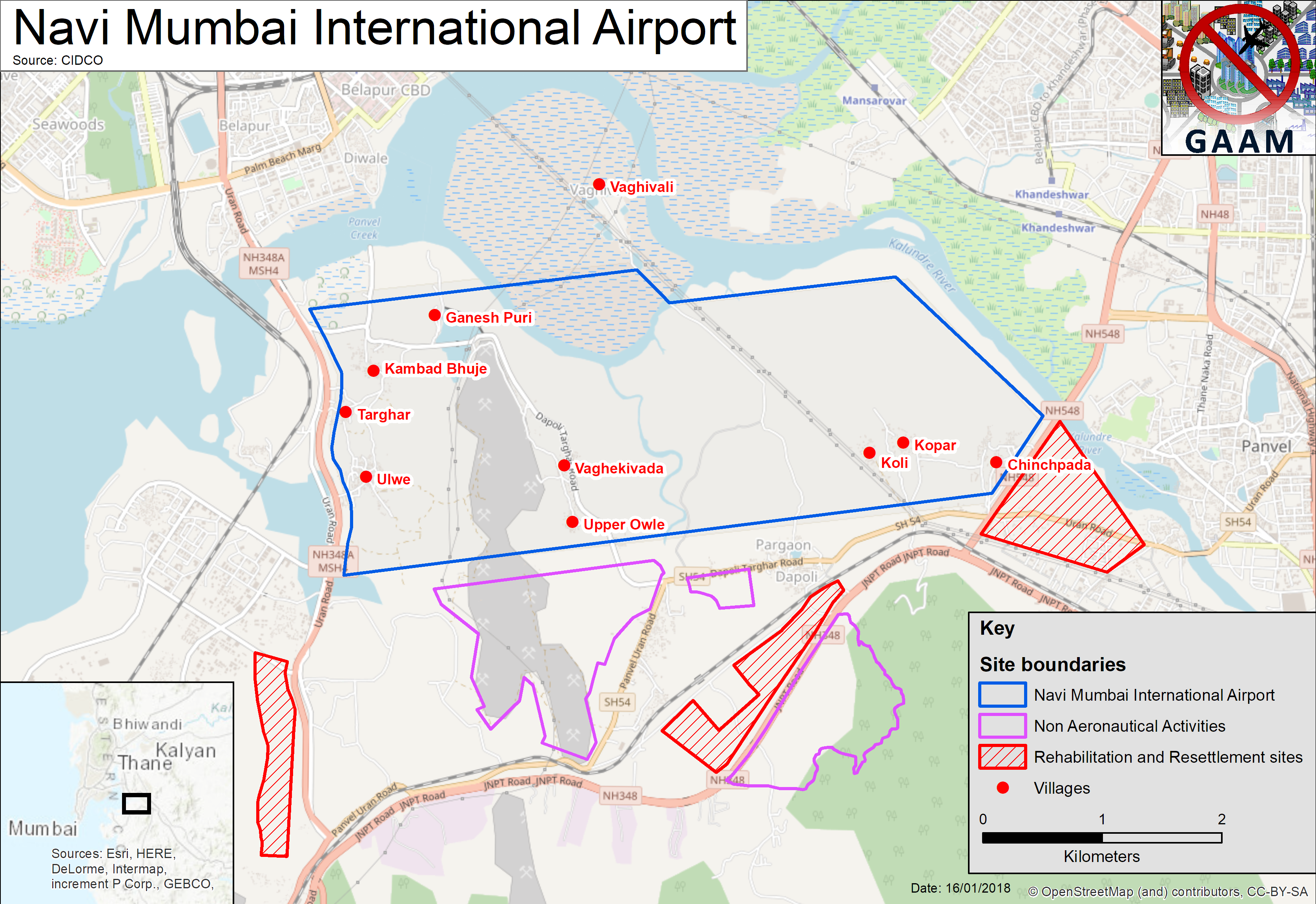
Approximately 3,500 families residing in 10 villages face displacement from their homes and land for a new airport in Navi Mumbai, in the Kovar-Panvel area 40 kilometres to the east of Mumbai on India’s west coast. First proposed in 1997 and approved by the government in 2007, the response of affected people, resisting land acquisition and demanding improved rehabilitation assistance, is just one of many factors that stalled the Navi Mumbai International Airport project. The inevitability of environmental damage led to delays in being granted government clearances. Biodiverse wildlife habitats encompassed within the site will be destroyed: 121 hectares of forest, 162 hectares of mangroves and 404 hectares of mudflats. Environmental groups have long criticized the airport site selection, saying that the government refused to consider possible alternatives. Waterlogged and low-lying, the site will need to be raised from 2 metres to 5 metres above sea level, posing construction challenges.
A mega-airport is planned, handling 10 million passengers annually upon completion of the first phase, rising to 60 million passengers per year upon commencement of full commercial operations with two parallel runways, which is scheduled for 2030. If this traffic projection proves accurate Navi Mumbai will be India’s busiest airport. The airport core area, allocated for aeronautical activities, is 1,160 hectares of land. In addition to the core airport site, three areas have been earmarked for non-aeronautical activities (airport-linked commercial development such as hotels and retail), taking the total airport area to 2,268 hectares. Three plots of land have been allocated for rehabilitation and resettlement for the affected villagers.
Levelling the site and diverting rivers
Villagers have not yet relocated to the resettlement areas. Yet, in October 2017, as they remain in their homes, massive earthworks preparing the site for construction of the airport began, a work programme that is expected to take between 18 and 24 months. The course of Ulwe river which runs north-south through the site is to be re-routed by 90° and the Ghadi river running alongside the northern boundary is also being re-channelled. Hills are being blasted away with explosives to make way for the airport runway, the soil and stones being utilized for filling in and levelling the site. The height of Ulwe hill, the largest hill on the site, is being reduced from 90 metres to 10 metres. Vast volumes of loose earth and stones will then have to be compacted down to make it stable enough to withstand airport operations.
Difficult terrain brings serious construction difficulties. The land is swampy and flood-prone, large areas are frequently waterlogged, especially during the monsoon season. “Even from a simple engineering point of view, building an airstrip on reclaimed land, mudflats and mangroves – it is going to be very unstable,” predicted Debi Goenka, executive trustee of the Conservation Action Trust. As of December 2017 most of the site was underwater. Critics of the airport project also point out the high level of state expenditure on pre-construction earthworks that are necessary to make the fragile coastal zone sufficiently resilient to withstand the new airport, an estimated ₹2,345 crore (US$370 million).
CIDCO (City and Industrial Development Corporation), a city planning agency formed by the Maharashtra state government, is responsible for implementing the airport project. GVK, an Indian conglomerate with interests in energy, resources, transport and other sectors, has been awarded the contract to build and operate the airport. By May 2018, CIDCO expects to hand the project over to GVK for completion of pre-construction groundwork on the airport site before the building phase begins. Predictions of project cost escalation have proved well founded. By 2017 CIDCO’s cost estimate for the project had more than tripled, escalating from US$753 million to US$2.5 billion.
As earthworks In November 2017 two thousand residents of the villages of Targhar, Pargaon, Ulwe, Kolhi, Kopar, Ganesh Puri, Chinchpada, Dungi and Manghar gathered to step up their demands for fair compensation and rehabilitation from CIDCO for vacating their land and homes to make way for the airport project. The villagers discussed many concerns including unnecessary land acquisition and united their struggles to form a new organization: Navi Mumbai International Airport Affected Peoples, which will take up their demands with CIDCO.
The villagers’ meeting followed a major protest by residents of six villages on 12th October, which brought pre-construction work on the airport site to a halt. An article on the mid-day.com news website stated that 5,000 people attended the protest. Only 10 per cent of the affected families had vacated their homes, over 3,200 families were still living on the site and they resolved to remain in their homes until the plots of land allocated for resettlement were developed. On 27th October it was announced that, following a meeting between CIDCO officials and affected residents, attended by 500 people and with a heavy police presence, work on the Navi Mumbai Airport site would resume under heavy police protection. CIDCO reported that four platoons of state reserve police had been made available.
Blasting damages houses, injures workers and villagers
The state is protecting the airport from people with legitimate grievances, but failing to protect people from construction of the airport. Blasting work caused residents to complain about tremors affecting their houses and has caused injuries. At the time of the October 2017 protest explosives were being set off three times per day, loosening the ground in order to cut and level Ulwe hill to make way for the airport runway. Taking place at a distance as little as 100 metres from people’s homes blasting sent stones flying distances of up to 200 metres, including into a nearby school. Vibrations from the blasting had caused cracks in the walls of houses in the village of Ulwe, making some people afraid that their houses might collapse.
On 6th January 2018 five engineers working in the site were injured, two of them severely, by supposedly ‘controlled’ blasting work that was underway 300 metres away from them. Explosions had triggered a landslide and the workers were hit by falling rocks. Villagers in Siddhart Nagar which is situated at the foot of Ulwe hill suffered injuries too; five women were bruised by stones coming through their roofs and a seven-year old boy who had been playing outside his house needed two stitches to his head. Affected residents, who had argued that blasting should not commence until they are rehabilitated, organized a protest march opposing blasting on the airport site and called for an atrocity case to be registered against CIDCO and GVK. Two days after the landslide, as GVK signed the concession agreement with CIDCO, the men of the village stalled work at the blasting site while the women made an unsuccessful attempt to meet with CIDCO officials at their offices. The father of the boy injured in the landslide, said “My wife and a few other women went to meet CIDCO officials, but they were not entertained. Why is it difficult to rehabilitate us when crores are being spent on the project?”
After the blasting injuries CIDCO officials ordered Siddhart Nagar residents to vacate their homes to get them out of the way while blasting work takes place, for two hours every day 1-2pm and 5-6pm. Villagers voiced strong objections to this disruption of their daily lives and being forced to stand in scorching sun. CIDCO’s lame excuse for undertaking the dangerous blasting work with people still in the vicinity is a claim that Siddhart Nagar villagers have not been rehabilitated because more than half of of the households were established after the 2013 cut-off date for eligibility. A representative of the villagers insists this is not the case and that they have documents proving their residency in the area for the past seven to eight years.
Residents’ long struggle for fair rehabilitation
Residents being displaced for Navi Mumbai Airport, facing loss of their homes, communities, land and livelihoods, have sustained a long-term struggle for fair rehabilitation. Back in 2010 a public hearing was boycotted by residents of all 18 affected villages standing to lose their land. Approval of the airport project appeared to be a foregone conclusion; journalist Nidhi Jamwal wrote that the hearing was ‘wrapped up in hour’, with the few journalists that attended having been told by their employers that negative stories would not be published. There was not much to report anyway as a recently completed Environmental Impact Assessment (EIA) and a study on the diversion and channeling of rivers were not made public. People from the affected villages stood outside the meeting waving black flags in protest, demanding due compensation.
Villagers being displaced for the airport, referred to as project affected persons (PAPs), are dissatisfied with the rehabilitation and resettlement areas and say that the offers of land and cash sums to build new houses in these designated areas are in sufficient to compensate for what they will lose. PAPS are being offered construction aid to build their new houses, but say that the amount, calculated in 2011, is low. Their request that construction aid be increased to reflect current costs seems particularly reasonable in the light of CIDCO’s repeated upward revision of airport construction costs.
At the time of the 12th October 2017 protest, which was precipitated by apprehensions over CIDCO’s looming 17th October deadline for villagers to vacate their homes, Nata Pratil, president of the committee of MLAs (Members of the Legislative Assembly) which is demanding justice for the 3,500 families facing displacement, said that the deal offered to villagers to give up their land was altered after they had agreed to it, the allocation of space for a new house being reduced. CIDCO claimed that the plots for displaced families were ready, but PAP representatives disputed this, saying that schools, utilities, streetlights, roads and a crematorium had yet to be developed. And PAPs said nothing had been done to make provision for replacing temples that will be lost to the airport. CIDCO had committed to allocation of plots of land suitable for relocation of ten old temples, along with compensation for rebuilding. In November 2017 some PAPs alleged that records proving their land ownership had been destroyed by CIDCO.
Loss of mangroves and the risk of bird-strikes
A significant regulatory hurdle to building Navi Mumbai airport, pertaining to the mangrove forest in the airport site, was removed in 2009. Coastal Regulation Zone notification, ensuring tight controls over construction, was amended in order to allow conversion of mangrove forest to an airport. Replacing mangroves with the impermeable concrete and tarmac of an airport will disrupt the water balance in the wider region. Mangroves are a natural buffer between land and sea, the interwoven roots preventing coastal erosion, absorbing rainfall and tidal surges. Excess water has to go somewhere and removal of mangroves for the airport could make the surrounding area more susceptible to flooding.
CIDCO’s suggestion of compensatory plantation to make up for loss of mangroves, about 200 kilometres distance from the airport site in Dahuna, met with criticism that these complex, locale-specific ecosystems, richly biodiverse and taking time to evolve, cannot be created instantly. CIDCO then suggested a mangrove sanctuary close to the airport site, commissioning a study of wetland bird habitats that was conducted by Bombay Natural History Society (BNHS). The study highlighted the conflict between airport operatiosn and birds. Dr. Deepak Apte, director of BNHS cautioned that “A mangrove park within the perimeter of aircraft takeoff and landing zones can be an extremely serious aviation hazard”. Mangroves are an attractive habitat for many bird species, so a mangrove sanctuary poses a risk of bird strikes, collisions with aircraft that can cause fatal accidents.
In 2015 the Ministry of Environment, Forest and Climate Change National Board for Wildlife withdrew the requirement for a mangrove sanctuary as part of the project. The developer will be required to make the area designated for the mangrove sanctuary unattractive to birds to reduce the risk of bird strikes. An environmentalist from Vanashakti, an NGO focused on forest, mangrove and wetland protection, questioned the sincerity of CIDCO’s promise of a mangrove sanctuary, wondering if it was known to be unfeasible due to the bird strike risk, and merely a ruse to help get clearance for the project.
Airport operations are likely to impinge upon birds habitats beyond the site – coastline, creeks, mangroves and inland wetlands. A survey conducted BNHS showed an estimated 266 bird species living within a 10 kilometre radius of the airport site, including the Karnala Bird Sanctuary. Aviation experts advised that a plan for a bird sanctuary to protect migratory flamingos, in the Panju-Funde wetlands, 20 kilometres from the airport site, would be under the take-off and landing flight paths and a bird strike disaster waiting to happen. Large birds such as flamingos pose the most significant bird strike risk. Debi Goenka criticized the airport authorities’ opposition to the Panju-Funde bird sanctuary: “In the name of development, we cannot simply kill all the beautiful birds and destroy their wetlands’ habitat. They could have easily shifted the proposed airport to some other place 10 years ago”
Interlinked megaprojects and car dependency
Construction of another megaproject, the Mumbai Trans-Harbour Link (MTHL), the longest bridge in India – is to be speeded up, for completion in time for it to be linked with Navi Mumbai Airport. Stretching across Mumbai Bay, six lanes wide and 22 kilometres in length, the new bridge will link the mainland with Sewri on the eastern edge of South Mumbai. Like the airport, the bridge is set to destroy birdlife habitats. First mooted in the 1970s it met with opposition because of the impact on Sewri mudflats, an area containing mangroves and providing an important feeding ground for the thousands of flamingos flocking there every winter. MTHL’s starting point in Sewri, extending along 5 kilometres of coastline, poses a threat to an estimated 20,000 – 30,000 flamingos and 38 hectares of formerly protected mangroves will be lost, along with 8.8 hectares of protected forest at the Navi-Mumbai end.
The shoreline sections of MTHL will impact on people as well as the environment. A 2016 assessment survey revealed that the homes of 229 families, 53 business premises and 10 commercial structures in Sewri will be demolished to make way for MTHL and an official outlined a plan to resettle then in Bhakti Park, Wadala, in southern Mumbai. Artisanal fisherfolk from nine villages whose livelihoods are impacted by MTHL will receive a one-time compensation fee. As of July 2017 over 3,000 compensation claims had been submitted and the Mumbai Metropolitan Development Authority (MMRDA) was about to begin sifting through the applications to identify ‘genuine claimants’. The cost of the MTHL bridge is comparable to Navi Mumbai International Airport at US$2.6 billion. Since 2005 when bids for the MTHL were first invited the cost has escalated significantly, by 350 per cent, due to delays, rising input costs, mandatory environmental and rehabilitation and design changes. Citizens will foot the bill directly through tolls and indirectly through various taxes.
A 5.8 kilometre coastal road connecting the MTHL bridge with Navi Mumbai International Airport is a megaproject in its own right; large stretches of the road will be elevated with a 1.76 kilometre section over mangroves to be built on stilts. The coastal road is just one of a proliferation of road infrastructure projects enabling traffic growth to support the new airport: new roads, widening of existing roads up to 8 and 10 lanes, loop roads and interchanges. Journalist Sanjay Banerjee envisages these ‘speed corridors’, described by CIDCO as enabling “smooth and seamless vehicular movements”, having an ‘octopus-like grip‘ across Mumbai. The airport-centric road building programme is designing in a high level of dependence on cars, it is based on a projection that 85% of air travellers will use private vehicles.
Residents of five villages threatened with the loss of their homes for a second airport on Jeju island have set up a protest camp and their resistance is garnering support from many organizations.
Plans for a second airport in Jeju, an egg-shaped island off the south coast of South Korea, have met with vigorous and sustained resistance since the sudden announcement of the project two years ago, in November 2015. The proposed site is in Seongsan on the east coast of the island and residents of the five villages that would be affected, losing their homes and farmland – Susan-ri, Sinsan-ri, Nansan-ri, Goseong-ri and Onpyeong-ri – were not even consulted. Resistance has intensified in recent weeks and on 10th October a group of residents and representatives of civic groups opposing the new airport assembled a protest tent outside the Jeju island government hall and began a sit-in. The vice-chair of Seongsan people’s committee against the 2nd Jeju airport project, Kim Kyung-bae, began an indefinite hunger strike and fellow protesters began relay fasting to show their support.
Campaign against 2nd airport press conference outside Jeju Provincial Office launching the protest camp on 10th October 2017. Photo: 연합뉴스
The Jeju Provincial Government threatened to remove the protest tent, delivering a warning letter to the organizations protesting Jeju’s second airport, which stated that, if the protest tent was not removed by 17th October the government would forcefully dismantle it and claiming that the protesters are “illegally occupying the roads and causing traffic problems”. Protesters countered that their protest tent is located far enough from the road to avoid causing inconvenience to vehicles or pedestrians, as can be seen in the photo below.
Airport opponents only resorted to this sit-in protest because the Jeju Provincial Government refuses to communicate with them and the resistance camp remains, demonstrating protesters’ determination to maintain a visible presence, make their voice heard, and prevent imposition of the project. The photo below was taken on 21st October, marking the 12th day of the anti-airport sit-in and hunger strike. At the time of writing the protest continues on its 14th day, as does the succession of visitors finding out about the campaign and showing their support.
#강정 제주 성산 제2공항 백지화를 위한 12일째 단식! 단식을 하시는 김경배 대책 부위원장, 얼굴이 창백합니다. 성산의 어른들이 방문, 걱정합니다. 이제 부터 걱정됩니다. pic.twitter.com/8LcghiPMI1
Airport plans are being pushed forward without involving the people who would be most seriously affected, the villagers facing the threat of eviction from their homes and loss of agricultural livelihoods. The protest camp builds on a series of small victories, recent actions which have successfully stalled the airport project, blocking a land survey and environmental impact assessment. More recently, on 18th September 2017, demonstrators brought a briefing session on the 2nd Jeju airport to a halt. The briefing session was organized without consulting residents of Seongsan where the airport would be built and held far away in the city of Seogwipo, a distance of about 60 kilometers. More than 70 people, residents from the affected villages and representatives of civic groups, staged a protest, challenging the procedural legitimacy of the briefing session, criticizing it as merely a tool for advertising the project and demanding a complete reassessment of the airport plans. The video below shows protesters gathering outside the meeting with a display of banners, then attempting to take the stage to make their voices heard, only to be blocked by a large number of officials.
Two years of resistance against a second Jeju airport
Over the two years since the second airport plan was announced there has been a series protests and rallies, with the participation of hundreds of people. Most of the site earmarked for the proposed airport, about 70 per cent, is a farming area so the project threatens agricultural livelihoods and food production. If the airport is built over 75 per cent of villagers of Seongsan would lose their homes and other villages would also be severely impacted. Anti-airport actions have drawn on shamanic traditions, channelling a multitude of spiritual energies such as the three founding fathers of the island and Youngdeung, the goddess of the wind and sea. Two years of resistance have seen houses sporting posters in their windows and streets bedecked with red and yellow flags and banners extending as far as 20 kilometers along the roads leading to affected villages.
This slideshow requires JavaScript.
Scores of villagers face being forced to leave their homes and farmland, sustaining their battle against the airport as they persevere with the cycles of rural life. In February 2017, as villagers were busy harvesting radish crops, Kang Wan-bo, chair of the Seongsanup Second Airport Opposition Committee, said that the government had failed to make any concessions regarding affected villagers’ objections and was attempting to force the airport plan through, even though Jeju’s 15 environmental NGO’s had joined forces to oppose it. When Governor of Jeju Province, Won Hee-ryong, made his first visit to the area for a year, villagers told him they felt as if they were being sacrificed for the tourism industry. Kang argued that continuing to expand the tourism on the island would be “ridiculous”, that citizens’ rights and protection of the environment should take priority over pursuit of an increase in tourist dollars.
A poll purported to show that a majority of respondents, 63.7 per cent, agree with the second airport plan. But the poll result was skewed because it only offered the two options of agreeing or disagreeing with building the second Jeju airport. Organizations protesting the new airport said that, in order to get a result that is more representative of people’s opinions, a range of options should be considered: building a second Jeju airport, expanding the capacity of the island’s existing main airport or reusing Jeongseok Airport, a facility near Hallasan National Park that is mainly used by private jets. Results of a poll conducted by organizations opposing the second airport showed just 24.4 per cent of respondents agreeing to the second airport. A higher proportion of respondents, 36.6 per cent, supported expansion of Jeju Airport and 20.8 per cent supported reusing Jeongseok Airport.
Plans for tourism megaprojects and an ‘Air City’
Airport planners and proponents envisage a second airport bringing an enormous influx of tourists to Jeju. But it would jeopardize the pristine natural environment that makes the island such an attractive tourism destination. Honinji Pond, a sacred historical area where farming on the island is thought to have originated, is near the proposed site. In addition the tranquility of a most unusual geological feature, UNESCO protected Seongsan Ilchulbong, also called ‘Sunrise Peak’, a visually striking volcanic cone 182 metres high with a green crater rising from the sea, would be ruined if aircraft flew nearby. A second airport would also support a suite of mass tourism megaprojects. Mainstream commercial tourist traps are in the pipeline, such as retail complexes, casinos and golf courses, along with theme parks and resorts commodifying Jeju’s distinctive ecological assets and unique heritage.
Plans for a second airport are also of megaproject proportions. Jeju Governor, Won Hee-ryong, stated that the new airport would be the largest project in the history of the island, costing US$3.5 billion and scheduled to be complete by 2025. Planners envisage a single runway facility with capacity for 25 million passengers per year, equivalent to current traffic levels at Jeju’s existing airport but the airport could be expanded with the addition of a second runway.
The airport would be the beginning of and focal point for an even larger development; an ‘Air City’, another term for an aerotropolis, is planned around the airport, comprising shopping malls, convention facilities and financial centres. Anti-airport campaign leaders have voiced concerns that ecological destruction caused by the airport is set to be compounded by urban sprawl from the accompanying aerotropolis. Another tourism-oriented megaproject plan connected with the ‘Air City’ scheme, for a high speed network of rail and bus routes linking the island’s main established and upcoming tourism centres – with the second airport among the key nodes – has raised concerns regarding the environmental impacts of construction activities.
Solidarity with the Jeju peace movement
Anti-airport campaigners are also concerned that a second airport might be linked with militarization of the island. Many airport serve both civilian and military functions, and in March 2017 former Air Force Chief of Staff Jeong Gyeong-du, said the second airport should have a search and rescue facility (SAR), perceived by some commentators as code for an Air Force base. Military intentions were confirmed in when Air Force Director of Public Affairs, Lee Sang-gyu stated that a feasibility study into constructing an air base would commence in 2018. In 2012 a scheme for an air base near the southwestern tip of the island, using an airfield in Daejeong-eup, was abandoned after a public outcry and the proposal for an air base at the second airport met with equally fierce protest. The Ministry of Transport Plans hastily contradicted the statements made by senior military officials, denying plans for an Air Force base.
In spite of these denials and an apparent U-turn many people are still suspicious that a second Jeju airport would be used as an Air Force Base. These concerns have galvanized support for the airport opposition from peace campaigners active in the long-standing resistance campaign against Gangjeong Naval Base – Save Jeju Now. Gangjeong campaigners joined Seongsan residents at the briefing session protest on 18th September, and have made regular solidarity visits to support the current protest camp. Links have been forged between movements opposing overdevelopment and militarization and are becoming stronger.
Construction of the enormous naval base in the tiny fishing village of Gangjeong on the southern coast of the island, with capacity for 24 warships, met with a sustained non-violent struggle. A decade of campaigning and direct action, blocking bulldozers and delivery of equipment, at the site entrance and taking to the sea in kayaks, repeatedly stalled construction. Gangjeong Naval Base was approved against the will of the 94 per cent of the village population who voted against it in a referendum. Jeju has a deep rooted culture of peace activism, it is known as the ‘island of peace’, and the naval base goes against this by militarizing the area and strengthening the country’s alliance with US defence interests. Construction of the naval base also caused environmental damage. Unique and delicate marine ecosystems were destroyed with serious impacts on marine food sources such as abalone (sea snails) and fishing livelihoods.
Since the naval base became operational, with the first US Navy vessel docking at the facility in March 2017, resistance continues with peace campaigners maintaining a lively presence outside the entrance gates. Gangjeong Naval Base is also linked with expansion of mass tourism; as a joint military and civilian port it is anticipated to begin docking giant 150,000 tonne cruise ships in the near future. The second Jeju airport project is over ten times larger than the naval base and the budget four times higher. But hopefully the scale of the project can be outdone by the strength of the opposition it has triggered. Hopefully the determination of the Seongsan residents who do not want to leave the homes, combined with the convergence of many individuals and organizations expressing support for their struggle, will lead to the cancellation of the airport project.
The campaign against the 2nd Jeju airport has a Facebook page.
Following extensive research GAAM has published a digital interactive map: Aviation expansion in Indonesia: tourism, land struggles, economic zones, and aerotropolis projects. The map includes 60 airports – operational, under construction and still at the proposal stage, plus two airport projects which were cancelled. The issue of land rights in particular is highlighted, documenting disputes and resistance against displacement relating to 25 airport projects. Two airports currently under construction in Java, Kertajati and Kulon Progo, are of particular concern because of human rights violations, including police brutality, against people resisting eviction from their homes and productive agricultural land. Aerotropolis development is planned adjoining both of these airports.
Screengrab of GAAM Aviation Expansion in Indonesia digital map
The digital map represents only a fraction of airport projects in Indonesia, which already has 237 operational airports with a government expansion drive aiming for 62 new airports within 15 years, bringing the total number to 299. Yet it demonstrates the exciting potential of online mapping for organizing, analyzing and presenting information. GAAM hopes to collaborate with other organizations in the development of online maps to develop a more comprehensive picture of aviation expansion and the impacts on affected communities, making the most of this wonderful technology to support our research, awareness raising and campaigning. The map was designed and produced by InTouch GIS using the Storymap app.
A forthcoming report, Aviation expansion in Indonesia: tourism, land struggles, economic zones, and aerotropolis projects, contextualizes the information in GAAM’s online map, examining the central role of aviation expansion in a government drive for tourism growth and the integration of several airport projects with other infrastructure such as road networks and ports, economic zones and aerotropolis developments. The report will be published by GAAM in partnership with the Third World Network (TWN).


 Proposed airport in Bulacan | Photo by San Miguel Corp.
 A mega-airport is planned, handling 10 million passengers annually upon completion of the first phase, rising to

