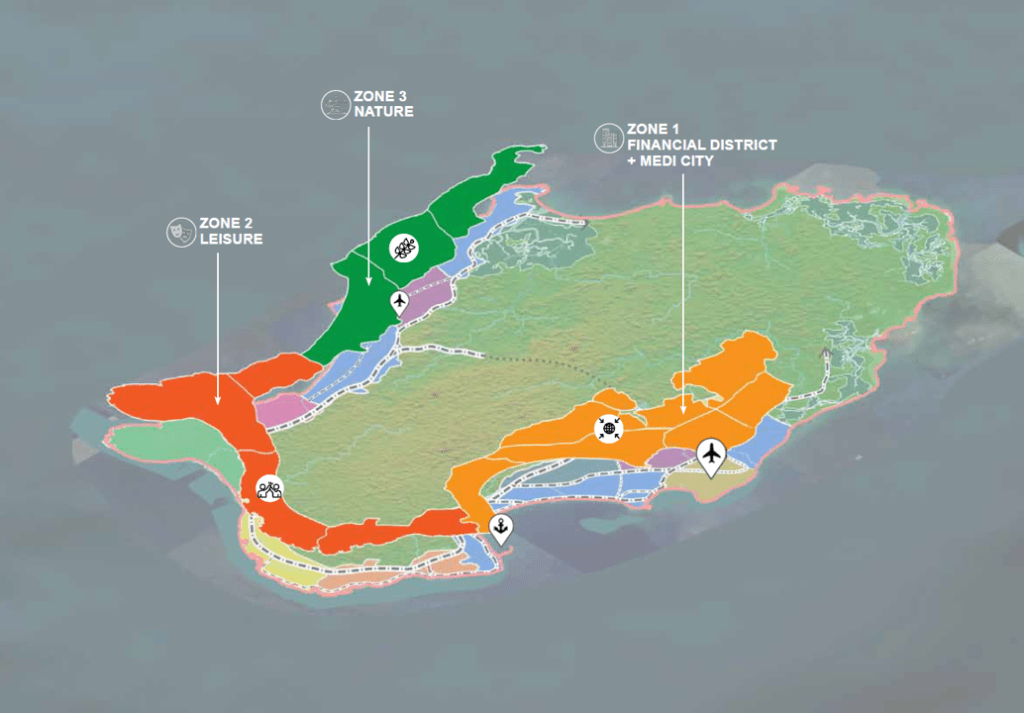
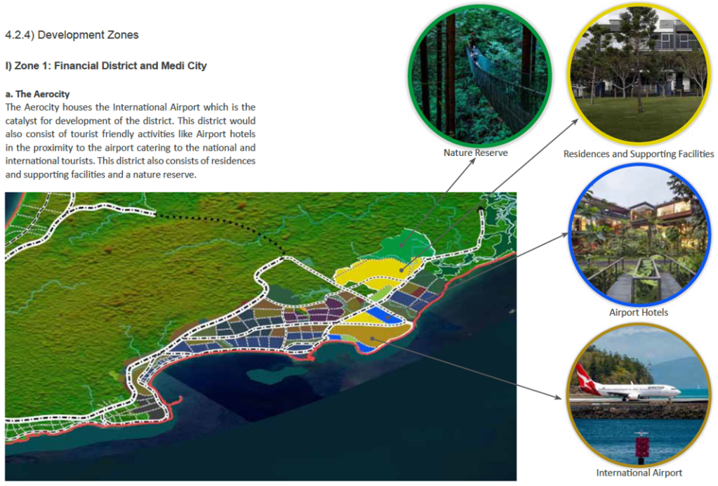
Construction of the Great Transfiguration Project – a mega tourism development n the St. Catherine area comprising luxury hotels, villas, chalets, visitors centre, shopping bazaars, housing and roads – is linked to expansion of St. Catherine Airport.

The Great Transfiguration Project (GTP), a mega tourism development project including hotels, villas, chalets, private housing, shopping bazaars, other facilities and roads in and around the St. Catherine area – a designated UNESCO World Heritage Site which includes St. Catherine’s Monastery and Mount Sinai – was announced by the Egyptian government in March 2021. Within weeks demolitions and construction works by private companies began. An August 2022 statement by the Egyptian Human Rights Forum (EHRF) detailed the project components, situation on the ground, impacts on and response from local communities and NGOs and comments from experts. Many contributors confirmed that GTP implementation had already caused serious, irreversible damage of nature, ecosystems, heritage and negative impacts on local people. EHRF’s statement said authorities had not included the local Jebeleya Bedouin tribe or the wider local community and that local organisations, community representatives, experts and representatives of St. Catherine’s Monastery (one of the oldest continuously inhabited monasteries in the world) and its inhabitants had not been consulted. A St. Catherine’s expert said homes were being demolished without compensation, part of the mosque had been demolished and the cemetery dug up. An eyewitness said many old olive and pistachio trees had been removed and some locals had worked together to replant them in different gardens. Construction of a 70km highway connecting St. Catherine with Al-Tur, on the Gulf of Suez, raised concerns over the environmental impacts. An expert on St. Catherine’s natural environment said, “This highway destroys an area designated by Egypt’s government as a nature protectorate, it cuts through the protected area and splits it in two, causing environmental ruin.”
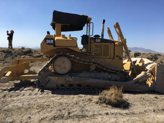
In March 2022 a Middle East Eye correspondent gathered testimony from several local people concerned about the impacts of the GTP. One resident spoke of concern for the future of the heritage site, saying, “What is sold to us as development is in fact ruining this ancient and beautiful city.” A tourism worker, one of several people commenting on social media and posting photos of demolished buildings, said, “The view to most of the ancient sites of the city will be blockade by the concrete buildings now constructed in it”. One resident spoke of bulldozers tearing down important buildings, replacing them with blocks of concrete. Another resident said, “We wake up every day to discover that some buildings have been demolished and other made of cement constructed instead of them.” Mada Masr reported that two anonymous sources said the government began implementation of the project before submitting environmental impact assessments. A resident raised concerns over the project’s water consumption in a city reliant on wells and tanker trucks from Al-Tur saying, “Where will you get water for those employed in hotels, chalets and homes? They’re building swimming pools while people still wait for the water trucks once a week.” Accommodation built for relocation of residents, apartments in multi-storey buildings, some of which were already housing displaced residents, were very different from Bedouin’s traditional single-floor dwellings with gardens. One resident said, “These do not look like our homes nor do they align with our customs. We would not know how to live comfortably. But when they relocate us, we will have no other choice.”
Concluding a 10th March 2024 inspection tour in St. Catherine to assess the development projects Prime Minister Mostafa Madbouli said the GTP would be Egypt’s gift to the entire world. He said the state had made significant efforts to implement the project, beginning with development of St. Catherine International Airport, located 20km northeast of the city, into an international airport. A World Heritage Watch press release entitled ‘Mount Sinai: A Sacred Landscape Disfigured by a Megatourism Project’, issued on 18th December 2024 stated, “A new urban world is being built around a people of nomadic heritage,” It stated that the site surrounding St. Catherine’s monastery had been transformed. Landscapes had been damaged, the rights of indigenous people violated, houses demolished, important cultural sites destroyed and Bedouins had lost tribal territories. Heritage groups around the world had raised the alarm about the scale of commercial and infrastructure development in St. Catherine. Fourteen plots of land confiscated from the monastery by the Court of Appeals included agricultural land, gardens and buildings protected as antiquities including Saint Panteleimon Church on Mount Sinai which dates back to the 6th-7th centuries. In 2023, UNESCO had asked the Egyptian government to halt further development projects, evaluate the impacts and prepare a conservation plan for the area. The requests were ignored and construction of concrete buildings including luxury hotels, new roads and development of St. Catherine’s Airport into an international facility with a 3km runway, enlarged terminal and VIP lounge continued. Speaking to New Lines Magazine in June 2025 an anonymous resident said, “the fate of personal property that falls in the way of this construction remains unclear. Assurances and fake promises change day by day.” An anonymous expert said Jebeleya people’s homes were being demolished with no compensation. The aforementioned bulldozed cemetery had been paved over to create a parking lot. Plans for 700 new housing units caused worries that Bedouins might be displaced. An anonymous expert said, “Many fear they could be compensated with an apartment, which does not suit their way of life. They need outdoor space – for their livestock and to plant.”
For more information including references for all source material see the case study on EJAtlas, the world’s largest, most comprehensive online database of social conflict around environmental issues – Great Transfiguration Project, Egypt