Farmland has been seized for a new airport in Spalding County, Georgia. Griffin-Spalding Regional Airport will serve corporate/private jets, has received federal, state and local government funding and is intended to spur real estate development in a large ‘Airport Impact Area’.
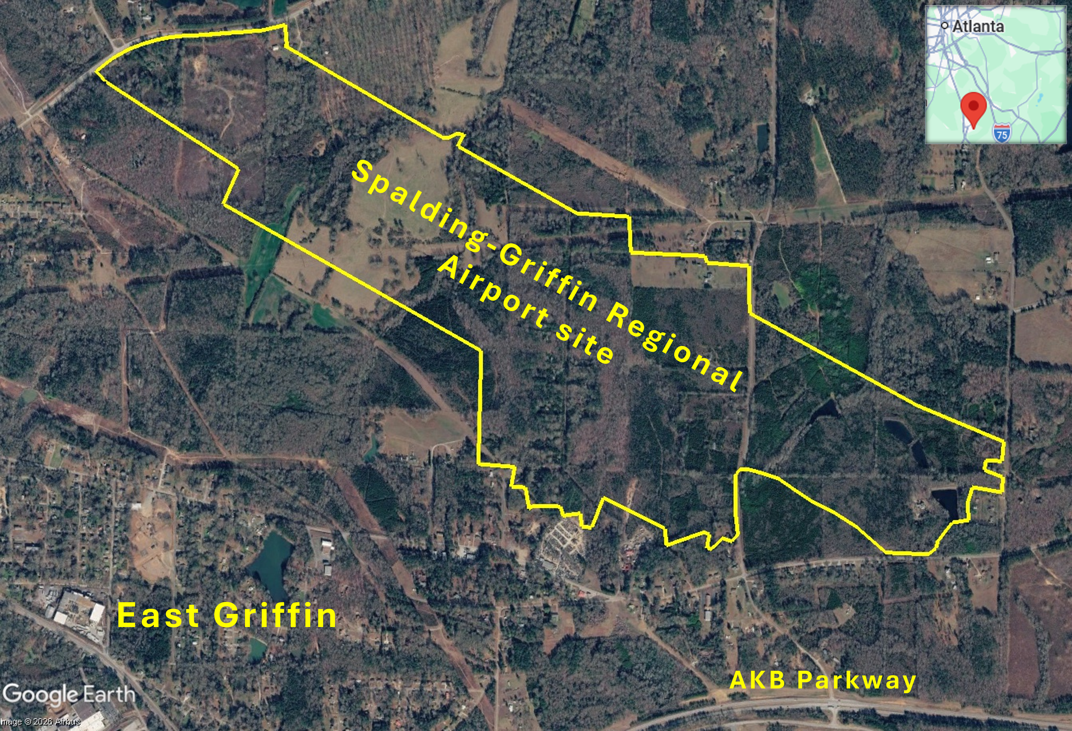
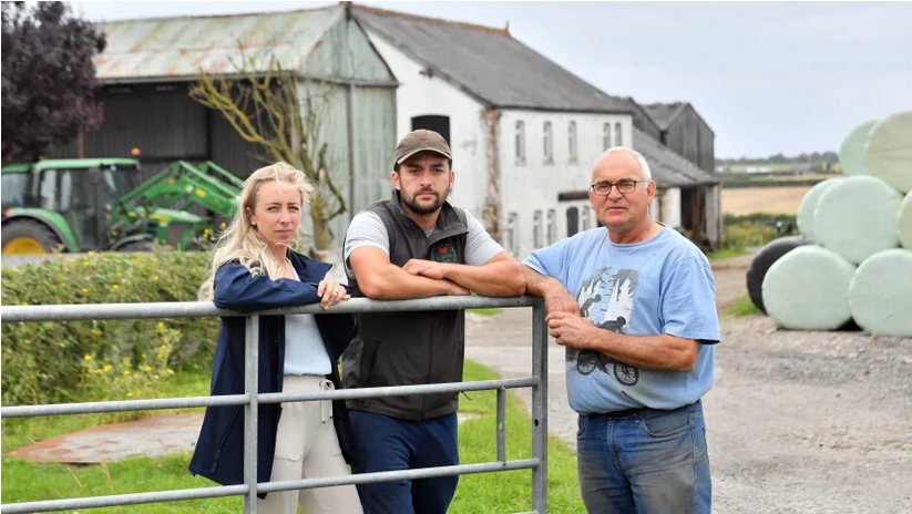
Construction of a new airport for corporate/private jets, northeast of the City of Griffin in Spalding County, Georgia, USA has commenced. A Farm Journal article by Chris Bennett describes the seizure of a large area of Jeff Melin’s farm by eminent domain (government power to take land, with compensation, for public use such as infrastructure projects) for the new airport. The 225-acre middle section of his 450-acre farm, containing pasture, cattle, woodland, deer, dove field and a pecan tree grove, has been appropriated, which will leave his farmland on either side of the airport site landlocked. Trees, many more than a century old, at the edge of the pecan grove have already been felled to make way for airport construction and concrete poles for power lines are being erected. Melin first learned of the airport project in 2012, from a newspaper article showing his farm as one of four or five possible sites for a new airport with 124 hangars for corporate jets. He says authorities never communicated with him face to face and would not listen to him, just sending letters, making announcements and conducting ever more studies. Now Melin has been issued with an order to vacate within 90 days; he has to remove equipment and at least 65 cows and 30 calves. Melin say he is being forced to accept payment for the land which is far lower than what comparable property has been sold for. But he does not want to part with the land at any price. Melin said, “They force me to sell against my will and then pay a fraction of the value. And I’m not allowed to turn them down. My story will make you question what kind of country you’re living in” The farm has been in the family since they arrived in Griffin in 1951. Year after year Melin has worked to improve the farmland but none of this was factored into the evaluation.
Griffin-Spalding Regional Airport will be far larger than the existing Griffin-Spalding County Airport located south of the central business district of the City of Griffin, only 3 miles southwest of the new airport site, . The 5,500-6,000 foot runway will be nearly twice the length of the established airport’s 3,100-foot runway. The Griffin-Spalding Regional Airport site is significantly larger as well, encompassing 730 acres, over three and a half times the size of the existing airport’s 198-acre site. The airport site was among seven potential sites identified in the Griffin-Spalding County Airport; Airport Site Selection Study prepared for the City of Griffin and Spalding County by LPA Group Incorporated in 2008. The introduction to the study states that an ‘aeronautical industrial park adjacent to a new airport’ could help achieve industrial growth plans and that in ‘the process to find suitable land area for a new airport, this study considered an additional area for industrial development’. A map of Site 6, subsequently selected for the airport, shows a 320-acre Airport Area with a 5,500-foot runway. A second map of Site 6 shows a larger 392-acre Airport Area including a 500-foot runway extension plus an adjoining 351-acre Industrial Area, extending south of the runway with a smaller area on the other side. The combined area of the Airport Area and the Industrial Area is 743 acres.
In March 2013, the Federal Aviation Administration (FAA) issued a Finding of No Significant Impact, (FONSI) Record of Decision (ROD) determining that ‘the project as proposed would not significantly affect the quality of the human environment’ and deeming an Environmental Impact Assessment (EIA) unnecessary. The FONSI decision was based on information contained in a December 2011 Environmental Assessment (EA) for a replacement airport, prepared by LPA Group, and other applicable documents. Two potential alternative sites to replace the existing Griffin-Spalding County Airport, where expansion is constrained by a large amount of residential and commercial development surrounding it, were considered. A runway at least 5,500 feet in length and 100 feet wide with a parallel taxiway would enable the new airport to accommodate 75 per cent of large general aviation aircraft including Learjets, Cessna Citation 500s, Raytheon Hawkers, Dassault Falcons and the Bombardier Challenger 300.
The EA identified the site where the airport is now being constructed as the Preferred Build Alternative, requiring acquisition of 320 acres of land comprising 51 land parcels, many of which were uninhabited so relocation of residents would not be necessary. The EA notes that land acquisition would result in conversion of the land from agricultural and residential use to aviation use and clearance of approximately 260 acres of forest. Forest types identified within the site boundary and runway protection zones included bluff, slope and ravine forest along with pine and oak-hickory successional forests. The site includes approximately 37.1 acres of prime farmland and 55.6 acres of farmland categorised as of ‘statewide importance’. About 33.5 acres of floodplain and 7,368 feet of streams would be lost to airport construction. Maps of existing land use and future land use in and around the airport site show large areas of Agriculture/Forest converted to Medium and Low-Density Residential with narrow corridors of ‘Open Space Network’. A large commercial area is shown south of the airport site, with smaller industrial areas and a large industrial area to the south of AKB Parkway. An expanded ‘ultimate build-out of the Airport’ with a 6,500-foot runway is ‘reasonably foreseeable’. This would require conversion of 239 acres of federally protected farmland and relocation of 49 acres of residences.
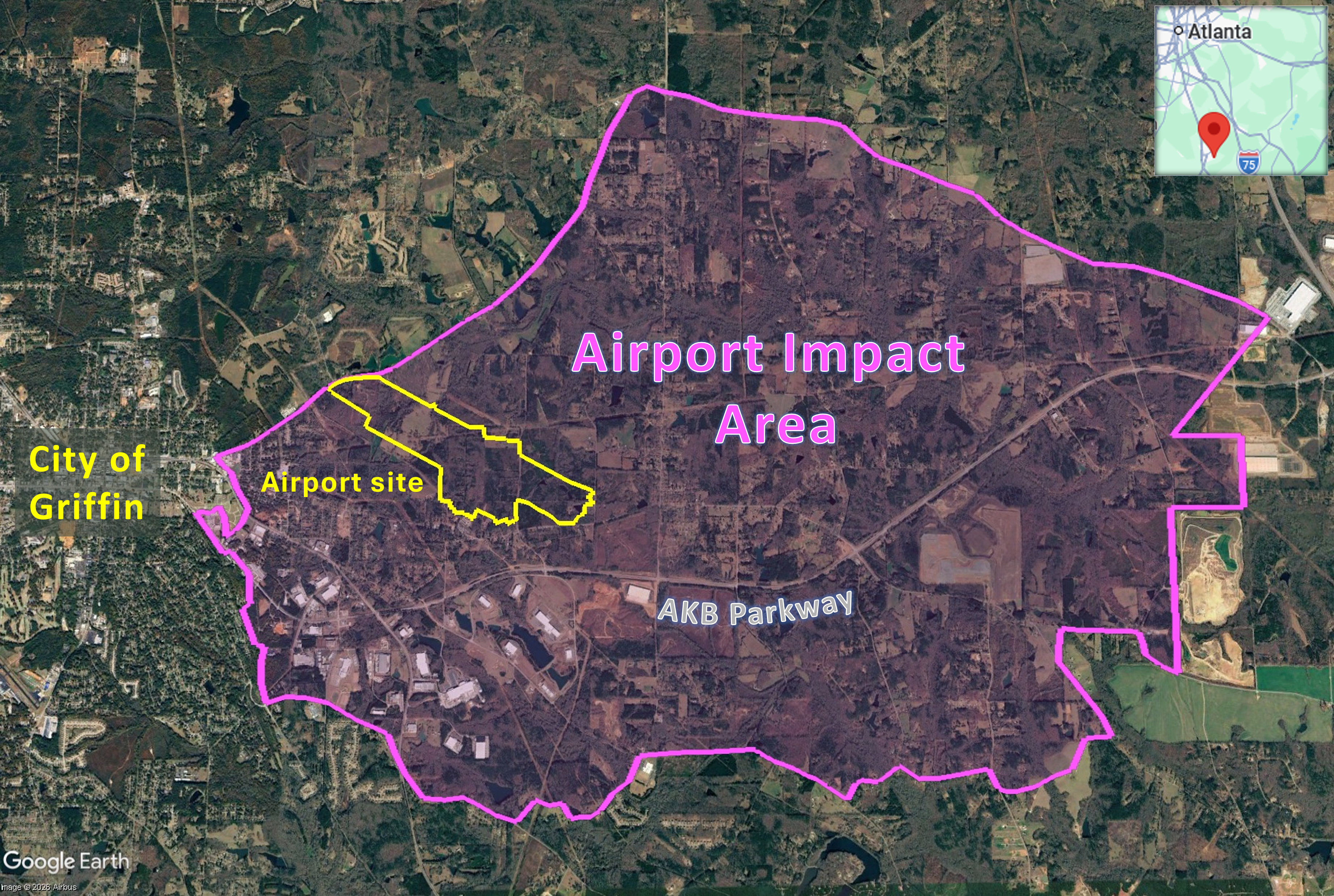
Georgia based Croy Engineering was selected as the prime consultant for development of the new airport in 2018, assisting with development of a financial plan and procurement of a USD8.5 million grant for the final design. The Griffin-Spalding Regional Airport Strategic Development Plan, prepared for Spalding County and the City of Griffin by KB Advisory Group based on data up to 2025, summarises the purpose of the project, ‘The new airport can serve as the driver for increased personal & business/corporate aviation traffic, expedite the corridor as a manufacturing and distribution hub, support technical training and research for the aerospace industry, and become a local destination for the community.’ Commercial and industrial corridor development is envisaged along the AKB Parkway which runs south of the airport site. The plan identifies an ‘Airport Impact Area‘ representing ‘potential real estate development capture’, forecasting future real estate demand for four key land use types: 29 million square feet of new industrial/flex (versatile property that can be utilised for a combination of warehouse, distribution, office and retail) space, 79,800-97,000 square feet of new retail space and 1,796 housing units by 2045, plus 180 additional hotel rooms by 2035. The Airport Impact Area, including the airport site, encompasses more than 18,500 acres of land. The report recommends infrastructure development to signal site readiness and reduce risks to developers, initially prioritising shovel ready sites to market the corridor. The Immediate Priority: Target Area 1 extends along both sides of the AKB. The Medium-Term: Impact Area is the entire Airport Impact Area.
The groundbreaking ceremony for Griffin-Spalding Regional Airport took place on 7th May 2026 with over 50 people in attendance, including Department of Transportation (DOT) Under Secretary Ryan McCormack who echoed President Donald Trump’s lauding of the One BIg Beautiful Bill Act with his description of the airport as “big and beautiful“, Congressman Brian Jack, Lieutenant Governor Burt Jones, GDOT Commissioner Russell McMurry and local leaders. Construction of the airport is scheduled to be completed by 2030. Griffin-Spalding Regional Airport, the first new airport to be constructed in Georgia since 2008, is supported by federal, state and local funding. Congressman Brian Jack stated that to date the project has secured a total of USD83.4 million including USD8.5 million from the Federal Aviation Administration (FAA) Airport Improvement Program, USD8.8 million from a Congressional Community Project Funding appropriation, USD47.2 million from the Georgia General Assembly, USD11.9 million from the Georgia Department of Transportation (GDOT) Airport Aid Development program and USD7 million from a local bond.