Polish government plans mega-airport and aerotropolis

The Polish government has approved a plan for a mega-airport and ‘airport city’ on a 3,000 hectare site. An area of farmland has been identified as a suitable location for the project.

On 7th November, the second day of the UN Climate Change Conference (COP23) in Bonn, the Polish government approved a plan to build a new mega-airport, called Poland Central Airport or New Central Polish Airport, handling as many as 100 million passengers per year. The project would result in a a major increase in Poland’s greenhouse gas emissions. Poland, host of the next climate summit, COP24, in December 2018, is already widely regarded as a climate renegade for its continued investment in coal plants, and had the dubious honour of being awarded Fossil of the Day award in Bonn, for its relentless efforts to siphon European Union (EU) funds for clean energy into subsidizing its ageing coal plants. Announcement of a major airport project makes a further mockery of the country’s commitments to address climate change.

The proposed airport site is in Baranów, a rural gmina (administrative district) 40 kilometres to the west of Warsaw, Poland’s capital city. The map below, commissioned by Polski Fundusz Rozwoju (PFR) in 2008 and included in an article published on 8th October 2017, about a meeting on the airport between representatives of the government and Baranów municipality, shows two areas identified as suitable for the airport project: a 3,421 hectare area to the north of the map and a larger 11,338 hectare area to the south. Another variant of this map was included in a 100 page document discussed at the government meeting  which adopted the airport plan, Poland’s biggest infrastructure project in recent years, on 7th November. At this meeting it was confirmed that the planned location of the airport is the Stanisławów village area, near the southern boundary of the area identified as suitable for the project.

Poland Central Airport
Map commissioned by PFR showing areas suitable for Poland Central Airport

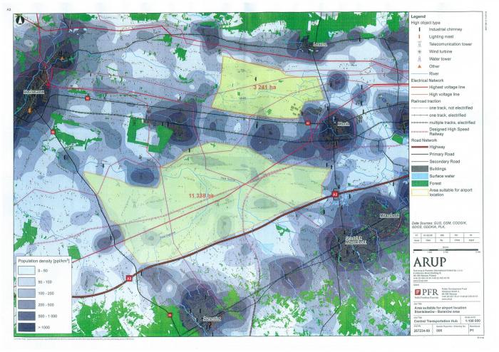
A map produced by GAAM shows the villages within the boundaries of the two areas identified as suitable for the airport project and the existing road and rail links.

PolandAirport

A satellite image of the Stanisławów village area, confirmed as the planned location for the new central airport, shows the villages and small parcels of cultivated land that characterize the wider area.

A mega-airport, multi-modal transportation hub and an aerotropolis

The schedule for the new airport is for preparatory works to be complete by the end of 2019, then for construction to be complete and operations to commence by mid-2027. A mega-airport is planned, one of the largest in the world with four runways, initially serving 45 million passengers per year, rising to 100 million, a passenger throughput as high as the world’s busiest airports, almost as high as Atlanta in the US and higher than the current traffic levels at Dubai Airport and Beijing Capital Airport. A multi-modal transportation hub is planned, integrating the new mega-airport with existing and new road and rail infrastructure. Plans for the airport include a rail station and the project is also referred to as Centralny Port Komunikacyjny (CPK), which translates as Central Communication Port. The proposed airport site is between Warsaw and Łódź, Poland’s third largest city, and a high-speed rail line connecting the two cities is planned. The A2 motorway running between Poland’s western and eastern borders is immediately south of the proposed site. Immediately north of the airport site is the rail line between Berlin and Moscow, via Warsaw,  providing a high-speed service that commenced operations in December 2016.

The 3,000 hectare land area for the new airport is far larger than would be required even if the number of passengers meets the projection of 100 million per annum. A 3,000 hectare site is more than 50 per cent larger than the world’s busiest airport, Atlanta in the US which handles 104 million passengers per year. Atlanta Airport’s site covers 1,900 hectares and encompasses substantial commercial development including more than 200 concession outlets such as retail, food and beverages. The oversized proposed land area for Poland Central Airport could be linked to plans for an ‘airport city‘ or aerotropolis. A 1,200 hectare new city is envisaged, with hotels and showrooms. Under the government resolution outlining plans for the new airport legal and infrastructural changes to Baranów would allow for construction of business parks, conference centres, an exhibition centre and office complexes.

A government financed megaproject

The budget for the airport project, combined with the road and rail infrastructure, is estimated at between €7 – 8 billion. Polish citizens will bear the brunt of the enormous cost of the project; the main investor is the government. The 7th November 2017 resolution announcing construction of the airport approved the financing structure as well as the location. An article in the second 2017 edition of Airport Development News, an industry newsletter published by Airports Council International, stated that two state-owned financial institutions, Polish Development Fund (Polski Fundusz Rozwoju – PFR) and Bank Gospodarstwa Krajowego (BGK), Poland’s national development bank, would be ‘heavily involved’ in financing the project.

Possibilities for European funding have been considered. The Airport Development News article states that between 75 and 80 per cent of airport construction will be financed by international institutions such as the EIB (European Investment Bank) and EBRD (European Bank for Reconstruction and Development). Such investment by the EIB and EBRD is doubtful as state aid rules preclude allocation of EU funds for construction of the airport. But a June 2017 article published by legal analyst firm Lexology stated that EU funds could be tapped for the road and rail elements of the project. The total cost of the rail infrastructure elements of the megaproject complex is estimated to be between €1.89 billion and €2.1 billion, the total cost of roads and highways between €424,000 and €1.6 billion.

Uncertainty over accessing EU funds has led to attempts to secure financing from Chinese sources. The airport was one of the vast transportation and energy infrastructure projects discussed at the May 2017 Summit of the Belt and Road in China, where the President of China repeated assurances about new credit lines by China Development Bank and China Exim Bank, and one of the outcomes was signing of a contract between Polish and Chinese state railways on facilitating container transport. The Asian Infrastructure Investment Bank (AIIB), a multilateral financial institution supporting construction of infrastructure in the Asia-Pacific region, is reported to have expressed an interest in co-financing the Poland Central Airport project, if it is in line with the bank’s policy of promoting ‘interconnectivity’ between continents, which would mean that the airport would have to promote passenger traffic with Asia. Potential benefits to Chinese exporters from the airport are evident. The project would support the Polish government’s intention to establish the country as a port of entry for Chinese goods into the EU single market.

Industry experts doubt feasibility of the new airport

Some industry experts are critical of the new airport, doubtful that a new global hub could compete with established European hub airports such as Schiphol and Frankfurt and saying that it would struggle to meet its traffic projections and fail to make a profit. And adoption of Poland Central Airport as a government priority reverses many years of sloughing huge sums of public money into several new small regional airports. A major new hub airport would compete with these regional airports, many of which are already struggling with low passenger levels and unprofitable. Some industry experts warn that opening a new hub airport would be likely to lead to the closure of several existing Polish airports.

Expenditure on a new airport that results in closure of established regional airports would be an astonishing waste of public funds. Between 2007 and 2015 Poland sank at least US$1.58 billion into building and expanding 14 regional airports, with 40 per cent of this funding coming from the European Union (EU). This was highlighted in a report Flights of fancy: A case study on aviation and EU funds in Poland published in 2012 by CEE Bankwatch Network which critiqued the development and operation of small regional airports which were not financially viable, placing a strain on regional and local government budgets, along with allocation of EU funds for rail connections to airports, arguing it should be redirected to serving mobility needs within regions.

Aviation industry consultancy CAPA (Centre for Aviation) reports that Poland Central Airport would replace Warsaw Chopin Airport, the city’s main airport located south of the city with limited room for expansion. Bloomberg also reports that, under the government plan for the new airport, Warsaw Chopin Airport would eventually be shut down. Closing Warsaw Chopin Airport would be a woeful example of enormous waste of public funds and short-sighted planning. A major, multi-million Euro programme of upgrades to Warsaw Chopin Airport, increasing its capacity to 10.4 million passengers per annum, was completed less than a year ago, in December 2016. The terminal was modernized including installation of new check-in desks and an observation deck, a new long-range fuel pipeline constructed and the runways, taxiways and apron have been upgraded. The airport upgrade programme cost €166,760,000 with the EU Cohesion Fund contributing €32,900,000.

Rafal Milczarski, CEO of Poland’s state-owned carrier, LOT Polish Airlines, has said that Warsaw Chopin Airport should be closed down and the land sold to real estate developers to help finance the new airport. This would certainly benefit LOT, a leading proponent of the central airport. Indeed, supporting growth of the national airline is part of the rationale for the project. But the role of LOT in the new airport is a factor in skepticism regarding its viability. LOT is a relatively small carrier with fewer than ten wide-bodied aircraft. A high level of investment would be required for LOT to become one of Central Europe’s main carriers, one of the goals of the the airport project. Critics are of the opinion that the LOT lacks the scale and financial capacity necessary for commercial viability of the new airport project. LOT Polish Airlines also has a history of government intervention to support ailing finances. The carrier was a direct beneficiary of state funds in 2012-2014 when it was rescued from bankruptcy with a €200 million state bailout.

There are serious doubts over the viability of the Poland Central Airport project. The only certainties are vast public expenditure on infrastructure and loss of a large area of farmland.

Nijgadh aerotropolis – 2.4 million trees could be felled, and 7,380 people displaced

An 80 square kilometre aerotropolis is planned in Nijgadh, Nepal. The projects entails displacement of 7,380 people and felling of 2.4 million trees.

A major aerotropolis is planned in Nijgadh, in the Bara District in southeastern Nepal, 175 kilometers south of Kathmandu. If the megaproject proceeds as planned as many as 2.4 million trees will be felled, and 7,380 people living in the Tangiya Basti settlement within the site will be displaced. The government has repeatedly stated that Nijgadh Airport with a 80 square kilometer site, will be the largest, by area, in South Asia. An airport city adjoining the airport is planned. The map below shows the proposed Nijgadh Airport boundary as reported in the Nepal Gazette on 5th June 2015. The site is between two braided rivers, Pashah to the west and Bakiya to the east. The northern boundary is the Mahendra Highway between the two rivers. Most of the site, about 90 per cent, is densely forested land, predominantly consisting of Shorea robusta trees, which are also known as Sal or Sakhua. The settlement in the middle of the airport site, where about 7,380 residents living in 1,476 households face eviction, is called Tangiya Basti.

Nepal - proposed boundary of Nijgadh Airport, an 80 square kilometre aerotropolis
Nijgadh Airport site boundary , as described in Nepal Gazette, 5th June 2015

A series of government announcements underlined determination to pursue the project. In June 2014 the government emphasized determination to attract investors, reportedly ‘preparing to complete the pre-construction works to spare the investors all the hassles whether the government, private sector or foreign investors invest on the project’ as preparations were being made to fence off the land. January 2016 saw another high level push to commence construction of Nijgadh airport. The Ministry of Culture, Tourism and Civil Aviation (MoCTCA) was instructed to begin land acquisition, site clearance and resettlement of affected people and the Ministry of Soil Conservation was directed to fell trees and clear the site for the construction of primary and access roads to the airport site within two months.

It appears that a confirmed investor in the airport has proved elusive. Public funds will be used to develop the project. On 24th May 2016 the government allocated US$46.4 million for the construction of Nijgadh Airport, for land acquisition, resettlement of displaced people, environmental impact assessment and preparation of a detailed project report. The Tourism Minister said the project would be developed in phases, beginning with a single runway facility with capacity for 20 million passengers annually, with the accompanying airport city to be constructed at a later stage. In January 2017 the government assigned preparatory work on Nijgadh Airport to the Nepal Army, tasking it with building a perimeter road and an access road to the area earmarked for the runway, and clearing trees to make way for construction.

600,000 trees could be felled to fund Nijgadh Airport construction

By May 2017 forest earmarked for Nijgadh Airport remained unfelled, but vast numbers of trees could be transformed from an obstacle to airport construction into a source of funding for it. A news article entitled ‘Money grows on trees for Nijgadh airport project‘ reported a statement by officials that a vast swathe of the forest, about 600,000 trees, will be felled for the airport. The market value of the lumber was estimated at nearly US$581 million, which would be sufficient to pay for half of the US$1.172 billion construction costs for the first phase of the airport. The Forest Ministry permitted the Tourism Ministry to conduct an EIA (environmental impact assessment) on the condition that 25 trees are planted for every tree that is cut down.

Tourism Ministry officials pointed out that tree planting on this scale this would be difficult to implement, as felling 600,000 trees would require the planting of more than 15 million saplings. The suggestion that 15 million trees could be planted is more than merely ‘difficult’; it is completely unfeasible. Any such mega tree plantation could not replace the rich biodiversity of an long-established forest ecosystem and an enormous land area would be required, inevitably entailing the wholesale obliteration of an existing ecosystem in order to plant such a huge number of trees.

2.4 million trees could be felled for 80 square kilometre aerotropolis

Subsequent announcements in July and August 2017 threaten the felling of even more trees for Nijgadh Airport, over 2.4 million, to make way for the full 80 square kilometer aerotropolis. The first phase of the airport will spread over between 1,000 and 2,000 hectares, and CAAN has assigned the Nepal Army to clear trees at the airport construction site and to build access and perimeter roads. The government has allocated US$14.6 million for the project this fiscal year with CAAN setting aside an additional US$29.2 million to pay for initial works, if required.

A short video of the forest at risk of being destroyed for Nijgadh airport was posted on Twitter, by Milan Dhungana, who commented: “It’s very hard to believe that this beautiful dense forest is soon to be vanished to give way to a new airport.”

Photos of the forest that is at risk of being felled were also posted on Twitter:

7,380 people face displacement

Residents of Tangiya Basti, 7,380 people living in the settlement in the midst of the forest land earmarked for Nijgadh aerotropolis, face displacement. In June 2014 MoCTCA was attempting to settle disputes over compensation for land acquisition and people’s demands for resettlement arrangements. By March 2016 the task of collecting land details had been completed, with land valuation about to commence, along with issuing public notices for land acquisition. Land had been categorized as under individual ownership, public land and ‘unidentified ownership’, the majority belonging in the latter category. A video shows the Civil Aviation Authority of Nepal (CAAN) sign erected at the Nijgadh Airport site.

A 35-day notice was published for landowners to apply for compensation in March 2017. The amount of compensation for land acquired for the airport had been confirmed and the notice required landowners to harvest their crops within a month, prohibiting them from cutting any trees or plants. But compensation is only available to a minority of residents who have recognized land ownership. A September 2016 project report by Tourism Secretary Prem Kumar Rai stated that 110 households were eligible for compensation, with between 80 and 85 of these households agreeing to the compensation and the remainder reluctant to accept the government’s offer. The majority of residents facing eviction, about 1,400 households, have been categorized as ‘squatters’. Chief of the airport project, Hari Adhikari, said that nothing had been done to resettle the ‘squatters’ living on the construction site. In July 2017 the Himalayan News Service reported that the government’s preparations to acquire land for Nijgadh Airport had left residents of the Tangiya settlement, about 7,380 people, fearing their displacement and in a state of panic over their resettlement.

Tangiya Basti residents are struggling for new homes and livelihood opportunities. The Tangiyabasti Stakeholders Committee stated that construction of the airport had made their future uncertain and held a press conference where they demanded rehabilitation. Residents facing eviction are insisting upon replacement land and food supplies, provision of water, electricity and education in the place where they will be relocated, and one job for each of the affected families. Chair of the Tangiyabasti Stakeholders Committee, Ramesh Kumar Sapotka, said that they would refuse to vacate the area unless their demands were addressed.

Tangiya Basti residents have been living in limbo for years, knowing they face eviction for the long delayed airport, which was proposed 20 years ago. The settlement was established by the government for flood victims in 1975 and the majority of people living there are from the marginalized Tamang ethnic group. For more than 40 years the government has failed to fund essential services for their established settlement, or to support their own efforts to develop these services. Tangiya Basti residents lack electricity, a reliable drinking water supply, electricity and roads. Construction of schools has been cancelled leaving pupils with a dangerous seven kilometer walk through dense forest to get to classes, with the risk of being trampled on by wild elephants that roam freely in the area. Many locals have to go to a neighboring town to make telephone calls and walk for several hours to reach healthcare facilities.

Fast-track to destruction

A 76 kilometer road, a ‘fast-track highway’, linking Nijgadh Airport with Kathmandu, has been on the drawing board since 1996. Reducing the travel time to the capital city to one-hour, is considered essential for the feasibility of the airport, but the road megaproject has also been plagued with delays. A Detailed Project Report (DPR) for the ‘fast-track’, a four-lane mega-highway, crossed by seven bridges and expanding to six lanes, was completed in August 2015.

Preparatory work for construction of the road was fraught with technical problems. The Nepal Army began excavation works without regard to the specifications for a four-lane expressway and the challenges of construction works on steeply sloping terrain, which could cause landslides. After years of delays the foundation stone for the expressway was laid on 28th May 2017, and the project handed over to the Nepal Army which will oversee construction. In the interim the road has fallen prey to the cost escalation common to megaprojects around the world. Over a seven year period the estimated construction cost of the expressway has doubled to over US$1 billion.

Megaproject mania, misplaced priorities

The Nepal government’s relentless pursuit of Nijgadh Airport and the fast-track continues in the face of criticism that the projects are draining funds from other regions of the country.  Meanwhile, other megaprojects languish incomplete and have fallen far behind schedule, such as a 28 kilometer tunnel to bring water from Melamchi to Kathmandu and transmission lines. Massive deforestation looms to clear the designated site for the airport even though funding for construction has not been secured. Successive administrations have put forward different plans for financing Nijgadh Airport. As late as August 2017 no decision has been made on funding. Two financial models have been put forward. BOOT public-private partnership (PPP) would involve foreign investment or private financing. Alternatively, the government would develop the project under the engineering, procurement, construction and finance (EPCF) model.

Megaproject mania, in particular massive government expenditure on a gigantic airport, multilane highway and aerotropolis, is a serious case of misplaced priorities in one of the world’s poorest countries. Nepal is still reeling from a devastating earthquake on 25th April 2015 which killed nearly 9,000 people and destroyed over 700,000 homes. Political infighting has delayed reconstruction and, in spite of billions of dollars pledged in aid, outside of Kathmandu the majority of affected families are still living in desperate conditions, in tents or makeshift shelters, enduring harsh winter weather and heavy monsoons. In these circumstances, spending vast amounts of public money on a mega-airport that would displace over 7,000 people is nonsensical.

Sukamulya villagers resist acquisition of farmland for Kertajati Airport

Residents of Sukamulya village in the regency of Majalengka, a predominantly rural administrative area in the West Java province, Indonesia, are resisting eviction for Kertajati Airport. They are fighting for their land and water, blocking officials from entering the village to measure land in order to acquire it for the airport. The stand-off between officials and villagers refusing to be displaced, which began on 8th August, is the latest chapter in twelve years of resistance. A plan for a major airport, taking up a land area of approximately 50 square kilometres, first surfaced in 2004.

The Front Perjuangan Rakyat Sukamulya (FPRS), which translates as the Sukamulya People’s Struggle Front, was formed to resist eviction for the airport and the campaign is supported by Indonesian land rights and agrarian reform NGO Konsorsium Pembaruan Agraria (KPA). As shown in a video by FPRS, hundreds of people are participating in the protests and women are playing a leading role. Sukamulya is bedecked with flags and banners. Road entrances to the village are being monitored day and night and blocked with tyres, preventing officials accessing land in order to measure it for the airport. A protest camp with a communal kitchen, using food harvested in Sukamulya and donated by villagers, helps maintain high spirits.

At the time of writing the blockade has been successful and the latest in several attempts at land measurement have been cancelled. Hundreds of residents blocked entry to the village, succeeded in holding back officials from the land agency, Badan Pertanahan Nasional (BPN) and police. On 1st September, hundreds of Sukamulya residents stated that they were ready to die in order to defend their land and demanded that the government treat them humanely. The action has garnered support from students and Majalengka farmers’ organization. Affected villagers are determined to avoid the fate of people whose land has been acquired for the airport; the level of compensation offered was insufficient for them to afford to buy land and build a house in nearby villages. But the government remains determined to impose the airport project. On 5th September, KPA reported that BPN was preparing to make another attempt to enter Sukamulya village to undertake land measurement, and that officials would be accompanied by a greater number of security officials.

12 years of resisting eviction for the airport

Over the twelve years since announcement of the Kertajati airport project there have been a great many protests. On 8th June 2007 hundreds of demonstrators rallied to protest against the threat of eviction facing at least 16,000 people from five villages. Speeches were followed by a mock trial of the Majalengka Regent, the head of the Regency. Demonstrators objected to lack of information about the airport project, including how much compensation they would receive from the government, and refused to be relocated.

Some residents have accepted compensation for their land and moved away, but the majority refuse to give land for the airport without fair land acquisition respecting their rights to accurate land measurement and appropriate compensation. Many reject the airport project entirely and are united in their refusal to give up their land for it. KPA maintains that the majority of the population of the 11 affected villages have opposed acquisition of their land and construction of the airport.

The FPRS video above documents a major protest on 25th January 2016. Hundreds of residents and their supporters rallied in front of the Majelengka land office and State Attorney office, arriving for the march in a procession of motorbikes and trucks carrying banners and posters. Rousing speeches voiced residents’ opposition to the construction of Kertajati Airport and the land acquisition process, protesting that it was not being conducted according to regulations. Villagers vowed that they would remain in Sukamulya. Hundreds of residents marched again on 22nd February 2016, demanding that delayed land compensation be paid to nearly 400 families and outraged that members of the community were being intimidated by officials. A video of the protest by the Majalengka police shows the presence of a large number of officials maintaining tight control of the demonstrators.

On 1st March 2016 the International Land Coalition (ILC) reported that conversion of the land for Kertajati Airport had resulted in the eviction of 10 villages. A tweet by ILC Asia showed a photograph of Iwan Nurdin, Secretary General of KPA, addressing a large group of evicted farmers from the affected villages.

On 2nd May 2016 hundreds of Sukamulya residents, supported by FPRS and KPA, rallied at the district government office demanding a fair land settlement. Speakers at the rally protested dishonesty in the land acquisition process including an inaccurate EIA (Environmental Impact Assessment) which stated that crop yields are far lower than are actually harvested. Intimidation by officials had forced some residents to flee from their homes and some had been detained.

Sukamulya villagers and their supporters defending homes and farmland from land acquisition for Kertajati Airport have good reason to be concerned that intimidation and harassment by officials may escalate into violence. There have been many clashes between security officials and people protesting against the airport and blocking access to land. A serious incidence of state brutality occurred on 18th November 2014. Without warning, hundreds of officials, surveyors escorted by armed police, arrived to measure land in the villages of Sukamulya and Sukakerta. Hundreds of residents attempted to block officials from entering the village area. Police responded with violence, firing tear gas and rubber bullets. Many citizens were injured from being trampled on and dragged away and some were beaten. At least five people were detained. A video shows a few minutes of the clash between authorities and villagers. Residents, distressed and angry, attempt to block officials from entering their village to conduct land measurement for the airport. Police and army officers herd people away from the village and confine them behind a fence. Many people are handled roughly by officials, pushed and shoved, and several are dragged along the road.

A mega-airport and an ‘Aerocity’

The developer of Kertajati Airport is PT. Bandarudara Internasional Jawa Barat (BIJB), referred to in English as West Java Airport and Aerocity Development Company. The planned airport land area, 1,800 hectares, far exceeds that which would be required should the airport meet its ambitious traffic projections of between 8 and 10 million passengers per year in the first phase of development, rising to 40 million passengers per year by 2035. It is larger land area than the world’s busiest airport, Atlanta in the US. In comparison, Atlanta Airport has a smaller 1,518 hectare site which includes a considerable amount of commercial development such as retail and warehouses. Yet Atlanta Aiport handles two and a half times the number of passengers planned for Kertajati Airport, just over 101 million in 2015. It is clear that land is being acquired for non-aviation purposes in addition to the area required for airport operations.

The proposed size of the airport creeps upwards. According to a BIJB video, by the beginning of August 2,500 metres of the planned 3,500 metre runway had been developed. But on 16th August the West Java province revealed plans to lengthen the runway even further, to 4,000 metres. The pale grey rectangle near the centre of the airport site is a completed section of the airport apron. The airport terminal is under construction adjoining the southern edge of the apron, and some of the farmland around it that is being destroyed, is shown in a tweet by BIJB:

Kertajti Airport is envisaged as the first phase of a larger ‘aerotropolis’ project, an airport surrounded by aviation dependent commercial and industrial development that is deigned to maximize use of air services. The full aerotropolis plan, with Kertajati Airport covering 1,800 hectares plus the proposed Kertajati Aerocity adjoining the airport site taking up 3,200 hectares, matches the 5,000 hectare project that was first mooted in 2004.

The Aerotropolis plan – a 50 sq km megaproject

A GAAM map shows the proposed boundary of Kertajati Aerotropolis that was indicated in a November 2015 presentation by a representative of BIJB entitled ‘KERTAJATI INTERNATIONAL AIRPORT & AEROCITY: INTRODUCTION & OPPORTUNITIES‘ at the Indonesia-Australia Business Week 2015. This event, aiming to develop closer investment and bilateral trade ties, was Australia’s largest ever business delegation to visit Indonesia. GAAM’s map superimposes the project boundary indicated in this document onto a 10th August 2016 satellite image of the aerotropolis site.

Kertajati Aerotropolis map.png

The map shows the area earmarked for the aerotropolis consists of farmland divided into strips and squares, villages and wooded areas. The rectangular area is the proposed site for Kertajati Airport. Adjoining the airport area is the Aerocity area, its southern boundary following the path of a river. In the BIJB presentation the claimed area of the Aerocity is larger than the 3,200 hectares stated by the project and government bodies, at 3,480 hectares. It could be significant that the land area indicated by the map in the BIJB presentation is even larger than stated in the text: 2,665 hectares for Kertajati Airport and 3,583 hectares for Kertajati Aerocity.

The first runway can be seen along the northeastern edge of the airport site. A second runway, parallel to the first and near the other edge of the airport site, is planned. Satellite imagery shows that earthworks have already prepared an area of land adjacent to the first runway for construction. The southernmost point of this area corresponds with the access road shown in the BIJB presentation. The footprint of the airport, and obliteration of farmland, threatens to extend beyond the site boundary with construction of access roads to the north and south of the airport area. A major road already runs through the planned aerotropolis site; the Cikampek-Palimanan Toll Road, part of the 653 kilometre Trans-Java Toll Road, runs through the Aerocity area, inside the southern boundary.

The Aerocity plan described in the BIJB presentation consists of typical aerotropolis components. Space would be allocated for hotels, retail, conference and exhibition centres, entertainment complexes, business park, offices, industrial and warehousing area, logistics and distribution facilities, aviation ancillary industries including MRO (Maintenance, Repair and Overhaul – of aircraft) and in-flight catering, plus a facility for Hajj and Umrah pilgrims. An ‘attractive incentives plan’, meaning subsidies for investors, is promised.

As a greenfield airport, and an aerotropolis, BIJB is not being constructed to serve established urban development, but to spur commercial and industrial development on the farmland surrounding the airport. Plans have been outlined for Kertajati Airport to become a ‘gateway’ to West Java; the airport and Aerocity would be an economic centre for the region, with direct access to the established Karawang industrial zone. Kertajati Airport is just one of 84 large scale infrastructure projects planned in West Java, including power plants, ports and roads, criticized by environmental forum WALHI West Java for the loss of farmland and triggering social conflict. Dianto Bachradi, Vice Chair of Komnas HAM (the Indonesian Commission for Human Rights), highlighted the private sector interests served by megaprojects. Specifically regarding airports he pointed out that employment opportunities for local people facing the loss of their livelihood from agriculture would be restricted to poor quality jobs such as baggage handler or parking attendant, and that the projects benefit large companies, not the local community.

As Sukamulya holds out against eviction recent announcements reveal more about the strategic significance of the aerotropolis to government and corporate interests. There is a military component as Indonesia’s state owned aerospace manufacturer,  PT Dirgantara Indonesia (PTDI), a firm servicing both civilian and military aircraft, intends to relocate from its current location in Bandung to a larger 300 hectare site on the land surrounding Kertajati Airport, anticipating that the new facility will be operational by 2019. And the aerotropolis scheme has spawned a plan for yet another megaproject; a power plant. This 190 hectare energy complex is planned for the aerotropolis to meet its own energy requirements, as the electricity supply currently under construction will only be sufficient to supply the airport, not the Aerocity.

Allocation of government funds for construction

Land acquisition, displacement of villagers, destruction of farmland, construction of the runway, taxiway and apron and earthworks to prepare land for construction of the terminal and access road have proceeded in the absence of confirmed financing to actually build the airport. Repeatedly, the government announced offers and interest from investors, from China, Korea and Turkey and from airport operator/developers including GMR Infrastructure (based in India) and Schiphol Group. In December 2015 President Director of BIJB, Virda Dimas Ekaputra, stated that no less than 40 domestic and foreign investors, from Switzerland, Turkey, Germany, Qatar and India, had expressed interest in development of ground infrastructure, such as the terminal.

As yet, foreign investment has failed to materialize, and there has been a series of announcements on financing of construction costs, all of which will fall on the government. On 18th January 2016 it was announced that construction of Kertajati Airport will cost about US$267.4 million, to be paid by central government through the transport ministry. Indonesian President Joko Widodo announced this financing decision during a visit to Majalengka. It was also stated that the West Java government is to pay for clearing 1,800 hectares of land. The government had withdrawn its search for an investment partner for development of the airport, redirecting potential investors to the proposed Aerocity adjoining it.

On 16th August it was announced that an as yet unspecified amount of provincial government allocated to the project had increased, the project having already spent most of the US$38 million in provincial finds already contributed. The most recent announcement of state financing is that the first phase of airport construction will be funded by mutual funds including the social security agency for labour. The financing scheme would be underwritten by state owned financial services firm Danareksa. Whilst this funding scheme would spare the government from spending the state budget on construction of Kertajati Airport the state would be liable for the debt incurred.

Farmland bulldozed and concreted over

BIJB videos show the progress of Kertajati Airport construction. A video dated 4th February 2016  begins with footage of the airport toll road, already a long ribbon of smooth tarmac. Next there is a shot of road grading for the access road. Bulldozers are shown in a puddled field of mud next to all that remains of a community that has been systematically erased, a tiny cluster of dwellings, and a single tree.


The camera pans away to show construction in the midst of a patchwork of green fields and bare earth where vegetation has been stripped away. At this stage, concrete has been laid for 2,500 metres of the runway. A bulldozer gouges at the earth, preparing a level surface for the airport apron, a gigantic rectangle of concrete. The tranquil soundtrack is at odds with what must be a roar of earth moving trucks, bulldozers and heavy machinery.

The BIJB video shows development  of the taxiway, with drainage channels running parallel. It is evident that the hydrological conditions of the airport site, low level land with a high water table, makes construction difficult. Adjacent to the apron, foundations for the terminal are being laid, and drainage channels dug into the flooded surface. Piles, long concrete posts, here called ‘pickets’, are being inserted deep into the ground. A total of 2,413 of these pickets are being driven down through weak layers of loose ground to reach rock or compacted soil that is strong enough to support the weight of the terminal building.

Water and food security concerns

A waterlogged site makes airport construction problematic, and drainage management will be challenging once the airport is operational, but airport operations require large volumes of water. There is a reservoir within the land that has been expropriated for the airport, the pale rectangular area near the southeastern corner. In June 2016, BIJB stated its intention to source its water requirements, initially about 30 litres per second but possibly rising to 60 litres per second, from within Majalengka.

Water may be plentiful in the area earmarked for Kertajati Aerotropolis, but it is a limited and precious resource. In Indonesia, the bigger picture is of water scarcity concerns, in particular on the densely populated island of Java. Diversion of water supplies from agriculture to industrialization impacts on irrigation of crops and therefore on food security. Kertajati Aerotropolis also poses a direct threat to food security due to loss of farmland to urban development. In May 2016 concerns were raised over food security implications of development on Majalengka farmland, in particular the prospect of the loss of 5,000 hectares for Kertajati Airport and Aerocity. Urban development on Majalengka wetlands could lead to a reduction in rice yields of 75,000 tonnes per year. Social and economic problems loom because of the loss of farmers’ livelihoods. In addition to rice many other crops are cultivated on the fertile Majalengka farmland, including beans, peppers, watermelons and mangoes.

A tweet posted on 19th July shows sheep grazing on green fields next to the terminal construction site, in the background is a skyline of piles and pile drivers pushing them into the soil. If Kertajati Aerotropolis progresses as planned this fertile farmland will soon be paved over.

Land conflict and Indonesia’s aviation expansion drive

Recent years have seen several airport-related land tensions and conflicts in Indonesia, in addition to the Kertajati case. About 300 kilometres to the southeast of the Kertajati Airport site, near the south coast of Central Java, Kulon Progo residents have struggled against loss of land and livelihood for a new Yogyakarta airport since 2011. Opposition to land clearance stalled construction of Kuala Namu Airport. It was expected to commence operations in 2009. In May 2013, as the airport prepared for opening, residents were still refusing the compensation on offer for eviction to make way for toll roads serving the airport. A week before the Kuala Namu opened, in July 2013, land disputes continued in five villages and more than 100 residents blockaded an arterial road.

A proposal for a second Bali airport, in the north of the island in the Buleleng Regency, was criticized due to pending displacement of agricultural communities and the sociocultural shock that would be inflicted on nearby villages, leading to an alternative plan for an offshore ‘floating’ airport. Yet the latest report on the new Bali airport plan still entails acquisition of populated land, stating that 656 hectares is required, predominantly residential land. The coastal villages of Pejarakan and Bumberkima would be affected and 3,335 people relocated, in order to offer wealthy tourists ‘panoramic views of white sandy beaches’. The elitist project aims to ‘cater to deep pocketed clients, servicing private jets’. Along with the airport investors intend to build aerotropolis-style development: hotels, restaurants and a yacht port.

In West Papua, dozens of families are refusing to be evicted for development of Manokwari Airport, and Sentani Airport finally agreed to pay compensation for acquisition of customary land in May 2016, after members of the four affected tribes blocked the taxiway with banana trees. In 2013 operations at Sorong Airport were disrupted by a rally demanding compensation for land.

Anti-airport movements in Indonesia are mindful of the long history of state brutality against people protesting confiscation of farmland for Lombok Airport. In the mid-1990s hundreds of families were evicted from 800 hectares of farmland for the airport. Oppression continued and in 23rd August 2005 a further 2,631 people were forcibly evicted for the airport. Then, on 18th September police, without provocation, fired into a crowd of 1,000 people who had gathered to commemorate Indonesia’s National Peasant’s Day and protest construction of Lombok Airport on fertile farmland. Thirty-three protesters were injured, 27 of them by gunshots, six from being beaten by police.

Kertajati aerotropolis is part of a wider Indonesian government drive for massive aviation growth. A target has been set to build 62 new airports over the next 15 years, in particular in isolated areas, which would bring the country’s total number of airports to 299. Inevitably, a number of these new airport projects will impact on rural communities and trigger resistance to displacement.