The oil supply crunch reduced deliveries of the vast volumes of diesel required for expansion of Phu Quoc Airport, including a second runway and passenger teminal, plus a luxurious VVIP terminal, scheduled for completion in time for the APEC 2027 forum.
Artist’s rendering of Phu Quoc Airport VVIP terminal as seen from above, resembling a sea eagle. Image: VnExpress
Within days of the US and Israel launching strikes on Iran restrictions on oil shipments through the Strait of Hormuz, a key transit route for diesel supplies to the Vietnamese island of Phu Quoc, had drastically reduced delivery of the volumes required for expansion of Phu Quoc Airport. The ambitious expansion plan aims to increase passenger handling capacity fivefold, from the current 4 million per year to 20 million by 2027 in the first phase, rising further to 50 million per year by 2050. The oil supply crunch had major impacts on construction works. Operation of between 160-180 items of heavy equipment for runway 2 works required 10,000 liters of diesel per day. Earthworks on 2,700 hectares of the runway 2 area, with 130 pieces of equipment, had been consuming about 27,000 liters per day. More than 60 per cent of the equipment had been shut down and 70 machine and vehicle operators temporarily laid off. Tankers carrying 200,000 liters of diesel had been arriving from the mainland every 7-10 days, but since 2nd March the supplier was only fulfilling existing orders and was no longer taking new orders. Yet publicity for the airport expansion continued. On 18th March 2026 Phu Quoc Airport unveiled more details of the VIP terminal design, with graphics depicting an exclusive lounge and luxurious, spacious arrival and departure halls that are markedly different from cramped and crowded facilities for regular travellers, with floor-to ceiling windows giving a ‘sweeping view of the sea’, ‘glossy black obsidian surfaces’, gold accents and a glass and gold sculpture of an eagle ray in flight.
Luxury aviation facilities for APEC 2027
Less than four months previously, on 28th November 2025, rapid progress of Phu Quoc Airport expansion was reported to be an aviation industry record with a second runway, closely followed by the ‘VVIP terminal’, then a second terminal, T2, all on schedule. The expanded airport is envisaged as a ‘gateway’ to a ‘Phu Quoc megacity of the future’ and on 31st December 2025 it was announced that airport construction was moving at an unprecedented pace; the steel framework for the 6,000 square meter VVIP terminal was in place. Initially, the VVIP terminal will host heads of state and high ranking delegations to the 2027 APEC (Asia-Pacific Economic Cooperation) Leaders Week meeting, a key event in the APEC 2027 forum themed ‘Connecting: Building Inclusive and Resilient Economies’. Exclusive facilities are being fast-tracked for an event purporting to promote inclusivity. Both the VIP terminal and Terminal 2 are being built ‘with the aim of delivering luxury standards and a premium passenger experience’. Luxurious passenger facilities will be accompanied by a new luxury airline, Sun PhuQuoc Airways, which ordered up to 40 Boeing 747 Dreamliner planes for international flights to its hub at Phu Quoc Airport. Boeing’s announcement emphasised the aircraft’s ‘superior comfort to passengers’ and described Sun PhuQuoc Airways as ‘well positioned to capture the next wave of premium tourism’. Two mega hotel projects reshaping the skyline to host global leaders and high ranking officials for APEC 2027 are similarly exclusive, designed for ‘diplomatic events, international conferences and high-end tourism’.
Forest land conversion for tourism projects
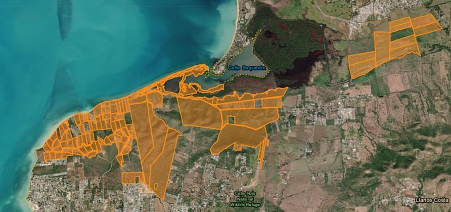
Conversion of 0.46 hectares of protected forest land for use in Phu Quoc Airport expansion was approved in February 2026. This small forest loss for tourism-related infrastructure is a continuation of a pattern affecting large swaths of the island. Elsewhere on Phu Quoc 286 development projects are planned and, as reported by Mongabay, since July 2024, authorities have permitted conversion of over 180 hectares of forest, most of it categorised as ‘special use’ due to ecological value or scientific importance. A key development, Rạch Tràm Ecotourism and Residential Project on the island’s north coast, required forced relocation of 508 households and clearance of 57.7 hectares of special use forest in Phu Quoc National Park. Development of Phu Quoc as an island tourism city was approved by the Prime Minister in 2022 and the 286 projects, at various stages of planning and development, span over 9,600 hectares, nearly 17 per cent of the island. Legal changes in 2024, expanding the type of developments for which forest land can be converted to include industrial parks and clusters in addition to ecotourism, resorts and recreation projects, facilitated a spike in forest conversion approvals. Since the amendments to land laws conversion of nearly 182 hectares of Phu Quoc forest, 77 per cent of this being special use forest, has been approved and the land designated for tourism projects.
Many local and diaspora organisations are opposing Esencia, a luxury tourism and residential megaproject with a private airport, in Cabo Rojo. The development has been granted generous tax credits and would require vast volumes of water.
In May 2024 two real estate firms, Reuben Brothers and Three Rules Capital, filed a master plan for Esencia, a USD2billion development in Boquerón Bay, Cabo Rojo on the west coast of Puerto Rico. Anchored by international hotel operators Mandarin Oriental Hotel Group, Aman Group and Rosewood Hotels and Resorts and containing up to 500 luxury hotel rooms and 900 tourist residences the complex would have a private airport. The Esencia website says the new ‘residential and hospitality community’ will have 3 miles (4.8km) of ‘pristine beachfront’. Plans also included two golf courses, spa, wellnesses centre, health clubs, equestrian centre, hiking and biking trails and a school.
The proposed Esencia plan, with sea views and a private airport, includes luxury hotels and residences and two golf courses. Image source: Reuben Brothers
The Esencia project was granted more than USD497 million in tax credits and in August 2024 four new tax exemptions of between 90 and 100 per cent were approved. A new decree granting 100 per cent fuel tax exemption for tourism-related activities was criticised for incentivising high levels of fossil fuel usage. Comité por la Verdadera Esencia del Suroeste sent statements to multimedia platform Marea Ecologista concerning the proximity of the project site to protected ecologically sensitive areas providing habitats for endangered birds such as the Puerto Rican nightjar. Responding to the absence of public hearings on permits and boundary demarcation for the Esencia project a town hall was convened by local community, environmental and cultural groups on 28th September 2024 where further detail of Esencia project components, including shopping malls and renovation of an airstrip to accommodate small aircraft, was shared.
The land within the site is rural and falls under two classifications. One category is rural land protected because of its ecological importance as it is located between two nature reserves and serves as a corridor for many species and also for its recreational value. The second category is rural land where there is more flexibility regarding development and in recent years mechanisms to evade compliance with the land use plan have been deployed such as declaring projects to be strategic or of critical importance. The project area contains at least 24 archaeological sites from the colonial and pre-colonial eras, many of which have not yet been explored.
On the first day of public hearings in March 2025 Cabo Rojo’s streets were filled with protesters holding posters and banners, many declaring ‘No to Esencia’ and calling the project an enclave for a small number of billionaires. The hall was not big enough to accommodate all the people opposing the project so many watched the proceedings on a screen in a tent outside. Puerto Rican groups opposing the project joined forces under the slogans ‘Defend Cabo Rojo’ and ‘No to Esencia’. The anti-Esencia movement gained support from Puerto Rican diaspora and pro-independence organisations, amplifying locals’ calls for cancellation of the project and holding protests throughout New York. For example, protesters occupied the lobby of the Mandarin Oriental Hotel and unfurled banners in the luxurious Columbus Circle shopping mall.
Officials said the project’s environmental impact statement (EIS) did not address the impacts on infrastructure and ecosystems and lacked hydrological studies. Esencia would place additional strain on water supplies, consuming more than 1.25 million gallons per day, a volume equal to more than a third of current consumption in the Cabo Rojo Municipality. This is a low estimate as it does not include the project proposal’s two golf courses which would increase the volume of water consumed per day to 2 million gallons. The development would require extraction from aquifers or connection to the existing drinking water system but neither of these options are feasible. Local fishers expressed concerns over the risk of damage to oyster beds and disruption of freshwater and saltwater flows that are essential to the health of the estuarine environment.
Many of the properties purchased for the Esencia project are shown in orange, agricultural land purchased in August 2025 is shown to the right. El Nuevo Día, 20/09/2025
By September 2025 project investors had spent approximately USD147 million on properties for Esencia and were on track to acquire the target of 809 hectares of land. Recent land parcel purchases were part of the Reserva Agrícola del Valle de Lajas (Lajas Valley Agricultural Reserve) and an airstrip. On 12th September the Department of Natural and Environmental Resources (DNRA) published a 29-page report firmly reiterating its opposition to the Esencia project and concluding that the plans did not comply with environmental laws. Significant findings included fragmentation of habitats hosting endangered bird species, severe impacts on Catesbaea melanocarpa, a rare, endangered lily and threats to the habitat of Anolis poncensis, a rare lizard species. The project’s so-called ‘ecological corridors’ lacked the connectivity of existing ecosystems and golf courses, artificial ponds and landscaping claimed to be mitigations would be part of the project’s negative impacts.
For more information including references for all source material and photos see the case study on EJAtlas, the world’s largest, most comprehensive online database of social conflict around environmental issues – Esencia project, Puerto Rico
Construction of the Great Transfiguration Project – a mega tourism development n the St. Catherine areacomprising luxury hotels, villas, chalets, visitors centre, shopping bazaars, housing and roads –is linked to expansion of St. Catherine Airport.
Great Transfiguration Project (GTP) area, Egypt. Aerial imagery: 2nd July 2023
The Great Transfiguration Project (GTP), a mega tourism development project including hotels, villas, chalets, private housing, shopping bazaars, other facilities and roads in and around the St. Catherine area – a designated UNESCO World Heritage Site which includes St. Catherine’s Monastery and Mount Sinai – was announced by the Egyptian government in March 2021. Within weeks demolitions and construction works by private companies began. An August 2022 statement by the Egyptian Human Rights Forum (EHRF) detailed the project components, situation on the ground, impacts on and response from local communities and NGOs and comments from experts. Many contributors confirmed that GTP implementation had already caused serious, irreversible damage of nature, ecosystems, heritage and negative impacts on local people. EHRF’s statement said authorities had not included the local Jebeleya Bedouin tribe or the wider local community and that local organisations, community representatives, experts and representatives of St. Catherine’s Monastery (one of the oldest continuously inhabited monasteries in the world) and its inhabitants had not been consulted. A St. Catherine’s expert said homes were being demolished without compensation, part of the mosque had been demolished and the cemetery dug up. An eyewitness said many old olive and pistachio trees had been removed and some locals had worked together to replant them in different gardens. Construction of a 70km highway connecting St. Catherine with Al-Tur, on the Gulf of Suez, raised concerns over the environmental impacts. An expert on St. Catherine’s natural environment said, “This highway destroys an area designated by Egypt’s government as a nature protectorate, it cuts through the protected area and splits it in two, causing environmental ruin.”
In March 2022 a Middle East Eye correspondent gathered testimony from several local people concerned about the impacts of the GTP. One resident spoke of concern for the future of the heritage site, saying, “What is sold to us as development is in fact ruining this ancient and beautiful city.” A tourism worker, one of several people commenting on social media and posting photos of demolished buildings, said, “The view to most of the ancient sites of the city will be blockade by the concrete buildings now constructed in it”. One resident spoke of bulldozers tearing down important buildings, replacing them with blocks of concrete. Another resident said, “We wake up every day to discover that some buildings have been demolished and other made of cement constructed instead of them.” Mada Masr reported that two anonymous sources said the government began implementation of the project before submitting environmental impact assessments. A resident raised concerns over the project’s water consumption in a city reliant on wells and tanker trucks from Al-Tur saying, “Where will you get water for those employed in hotels, chalets and homes? They’re building swimming pools while people still wait for the water trucks once a week.” Accommodation built for relocation of residents, apartments in multi-storey buildings, some of which were already housing displaced residents, were very different from Bedouin’s traditional single-floor dwellings with gardens. One resident said, “These do not look like our homes nor do they align with our customs. We would not know how to live comfortably. But when they relocate us, we will have no other choice.”
Concluding a 10th March 2024 inspection tour in St. Catherine to assess the development projects Prime Minister Mostafa Madbouli said the GTP would be Egypt’s gift to the entire world. He said the state had made significant efforts to implement the project, beginning with development of St. Catherine International Airport, located 20km northeast of the city, into an international airport. A World Heritage Watch press release entitled ‘Mount Sinai: A Sacred Landscape Disfigured by a Megatourism Project’, issued on 18th December 2024 stated, “A new urban world is being built around a people of nomadic heritage,” It stated that the site surrounding St. Catherine’s monastery had been transformed. Landscapes had been damaged, the rights of indigenous people violated, houses demolished, important cultural sites destroyed and Bedouins had lost tribal territories. Heritage groups around the world had raised the alarm about the scale of commercial and infrastructure development in St. Catherine. Fourteen plots of land confiscated from the monastery by the Court of Appeals included agricultural land, gardens and buildings protected as antiquities including Saint Panteleimon Church on Mount Sinai which dates back to the 6th-7th centuries. In 2023, UNESCO had asked the Egyptian government to halt further development projects, evaluate the impacts and prepare a conservation plan for the area. The requests were ignored and construction of concrete buildings including luxury hotels, new roads and development of St. Catherine’s Airport into an international facility with a 3km runway, enlarged terminal and VIP lounge continued. Speaking to New Lines Magazine in June 2025 an anonymous resident said, “the fate of personal property that falls in the way of this construction remains unclear. Assurances and fake promises change day by day.” An anonymous expert said Jebeleya people’s homes were being demolished with no compensation. The aforementioned bulldozed cemetery had been paved over to create a parking lot. Plans for 700 new housing units caused worries that Bedouins might be displaced. An anonymous expert said, “Many fear they could be compensated with an apartment, which does not suit their way of life. They need outdoor space – for their livestock and to plant.”
For more information including references for all source material see the case study on EJAtlas, the world’s largest, most comprehensive online database of social conflict around environmental issues – Great Transfiguration Project, Egypt
A new international airport under construction in the Pedernales province in the southwest of the Dominican Republic, for commercial and private flights, is integral to development of a high-end coastal tourism complex.
Cabo Rojo International Airport construction site. Satellite image 09/09/2024
In January 2024 the government of the Dominican Republic announced construction of a new international airport in the Pedernales province in the southwest of the country. The site is in the Manuel Goya community, part of the Oviedo municipality. A Spanish firm, Acciona Construction SA, was awarded the contract to build Cabo Rojo International Airport, even though its bid was the most expensive. The RD$3,961 million (€62 million) contract, awarded in June 2024, included construction of a 3.1 kilometre runway, taxiway, aprons for Boeing 777 aircraft (the world’s largest twin-jet aircraft accommodating up to 368 passengers) and drainage works. The new airport will serve luxury tourism and private aircraft (private jets). Director of the Airport Department, Víctor Pichardo, highlighted the new airport’s potential to transform tourism in Pedernales by attracting both commercial flights and private aviation, noting that each year more than 40,000 private aircraft fly over the Carribean. He said the new airport would position the Dominican Republic as a hub for high-end tourism. Construction of the new Cabo Rojo Airport (also known as Pedernales Airport) is scheduled to be complete by the end of 2025; it is anticipated to handle up to 1 million passengers annually within 17 years, making it the third busiest airport in the country.
Artist rendering of development of planned luxury tourism development near the new Cabo Rojo International Airport and expansion of Port Cabo Rojo. Image: Dominican Today
The new Cabo Rojo International Airport, will form the basis for a new coastal tourism complex with 12,000 rooms located just 15 minutes away (about 25 km). The two locations are already connected by a major highway: DR Route 44. The tourism complex site is near the existing Cabo Rojo Domestic Airport, a civic/military airport currently receiving a few small aircraft, carrying 2-30 passengers, per week and serving operations of the Dominican Air Force. Tourists will also be delivered to new resorts via Port Cabo Rojo, which is expanding into a facility capable of receiving two large cruise ships carrying up to 15,000 visitors. Large volumes of fresh water will be diverted to the tourist area via a new aqueduct which will supply 8,000 tourism rooms. As of July 2024 the ProPedernales tourism development trust, a Public-Private Partnership (PPP) with the government holding a 52% stake and the private sector holding 48%, reported a total investment of USD130 million on Cabo Rojo tourism, focused on the first three hotels and the airport runway. In addition, the Dominican Government had spent nearly USD30 million on water projects, site conditioning, planning and design to prepare for and support the initiative.
Six major international hotel chains, ‘a who’s who of luxury and all-inclusive resorts’, are building new properties in Cabo Rojo: Hilton, Marriott International, therostar Group, Karisma Hotels & Resorts, Amresorts (part of World of Hyatt) and Sunwing. Luxury tourism development just 15 kilometres away from the border with Haiti, gripped by gang violence and a humanitarian crisis, might seem incongruous. But the Dominican Republic has reinforced the border with Haiti with more than 13,000 troops and the first phase of a high-tech ‘smart’ border wall with drone patrols, surveillance towers and night vision cameras is nearing completion. The exclusivity and high security requirements of luxury tourism can go hand in hand with militarisation; the established Cabo Rojo Airport nearby already serves the Dominican Air Force.
At a June 2025 National System of Protected Areas (SNAP) conference a number of environmental experts stressed the importance of responsible tourism development in Cabo Rojo, avoiding repeating the mistakes of some other Dominican tourist destinations by protecting the region’s ecology and directly benefitting local communities. But problems have been reported in the earliest stages of Cabo Rojo’s tourism development. In August 2024 environmental organisation Grupo Jaragua said the project was proceeding without clear compensation plans for affected residents of the Oviedo municipality, where the airport is being constructed. A community leader reported that tractors had destroyed land. Two months later a truck drivers’ union took strike action protesting non-payment for tranport of fill materials used for airport construction, saying the amount being paid per kilometre was not even sufficient to cover their fuel costs. The government is providing a high level of financial and infrastructural support to tourism and airport megaprojects that will primarily benefit airlines, major international hotel chains and cruise ship lines, not local businesses, and only wealthy visitors will be able to afford to stay in the luxury hotels. And the new high-end tourism complex may well boost the number of private aircraft flights, only affordable to a small number of very wealthy people, at Cabo Rojo Domestic Airport.
Vlora Airport, opposed by many environmental organisations, has received a high level of government support and will serve luxury tourism developments.
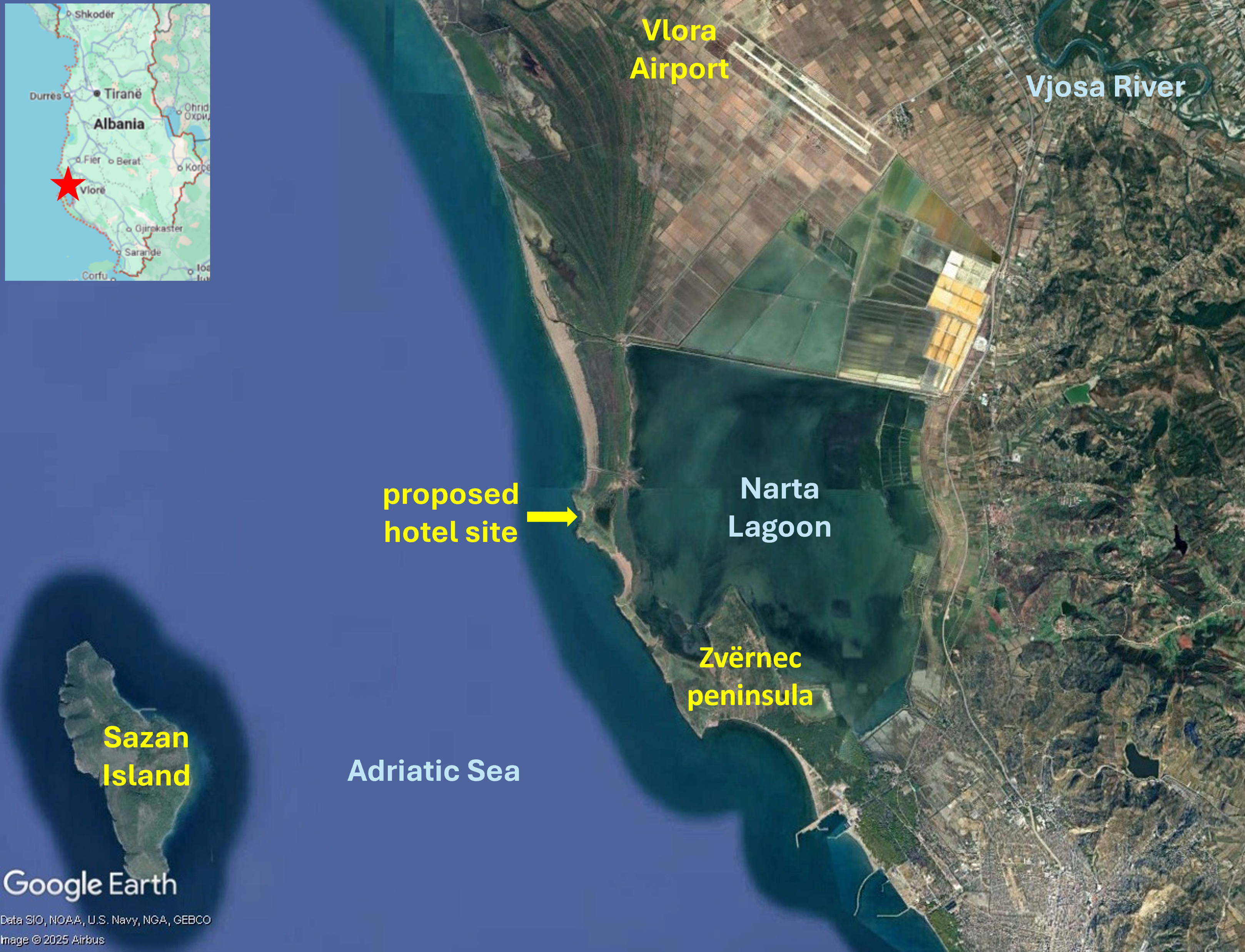
Map of southern Albanian coast showing Vlora Airport, Sazan Island and Zvërnec peninsula. Satellite imagery: 29/08/2023
Vlora Airport, a major construction project nearing completion in the Vjosa-Narta Protected Landscape on the South Albanian coast, has been opposed by many environmental organizations, including Protection and Preservation of Natural Environment in Albania (PPNEA) and EuroNatur, since it received parliamentary approval in February 2018. The project site is near Narta Lagoon, a habitat for many iconic bird species such as flamingos and the endangered Dalmatian pelican. The wider Vjosa Delta area, a complex of wetlands, marshlands, woodlands, reedbeds and sandy beaches, is vital for bird migration routes. A March 2021 letter from a coalition of NGOs to members of the European Commission and Parliament, calling for support in urging the Albanian government to respect national laws and international conventions it has ratified, and to reconsider plans for the airport, was signed by 41 organizations. In the same month it was announced that Mabco Constructions had been awarded the tender for constructing Vlora Airport.
On 7th May 2025, the day before the first test flight landed on the Vlora Airport runway, environmental activists, including representatives of PPNEA and citizens, protested in front of the Supreme Court. For over a year the court had not made a decision on returning a case against construction of Vlora Airport to the Court of Appeal; the lawsuit had been filed on 23rd November 2022. Protesters said the Supreme Court had deliberately delayed the legal process in order to facilitate completion of Vlora Airport. The first plane to land at Vlora Airport, on 8th May 2025, was the private plane of Behgjet Pacolli, owner of Mabco Constructions, the majority shareholder of the consortium constructing the airport. EuroNatur dismissed the test flight, showcasing Vlora Airport just three days before parliamentary elections, as a “big PR show”. The airport was not yet fully operational, neither the runway nor the terminal had been completed. Alexander Trajce, PPNEA Executive Director, said, “While the government is flying-high with the propaganda for the airport, what’s actually happening on the ground involves a rushed and chaotic development built inside a protected area, a myriad of safety concerns both during construction and for future operations.”
Construction fatality and investigation into possible corruption
Just 19 days before the test flight an accident a construction accident resulted in a fatal injury. A 38-year-old worker at the Vlora Airport site died on 19th April 2025 after falling from a height. Two construction company employees were arrested on suspicion of violation of workplace safety regulations. Construction of Vlora Airport has also triggered investigation into possible corruption. The Special Prosecution Office against corruption and Organised Crime (SPAK) announced the investigation in early July 2025, stating, “The Special Prosecution Office against Corruption and Organized Crime has registered criminal proceedings regarding the Vlora Airport concession contract. This proceeding is in the preliminary investigation phase.” SPAK is investigating the details of the agreement between Mabco Constructions owner Behgjet Pacolli and the Albanian government and the contract for Vlora Airport construction.
An unprotected delta and Law 21/2024
Conservationists had been hopeful that the government’s creation of Vjose Wild River National Park in 2023 would protect the Vjosa Delta from further destructive development. But the designation only covers the river and streams, not the delta which remains a target for commercial development, with only limited protection subject to Prime Ministerial veto. As airport construction continued, near Narta Lagoon at the heart of the delta, Zydjon Vorpsi of PPNEA warned that while the lagoon may still exist as a water body there will be serious hydrological impacts and aircraft noise and bright lights will disorientate and frighten away birds and turtles. Vorpsi also said Vlora Airport would lead to other development that will “transform the area, resulting in complete urbanisation of the delta”. Development in areas surrounding Vlora Airport has been facilitated by Law 21/2024, a change to the law on protected areas that was rushed through the Albanian parliament in February 2024. Many environmentalists were critical of the new legislation as it enables existing laws to be swept aside to permit construction of upmarket, luxury, five-star, tourism resorts in unprotected areas of the delta. PPNEA, EuroNatur and other environmental and conservation groups said the new law conflicts with international conventions signed by the Albanian government, including the Bern Convention on the Conservation of Wildlife and Natural Habitats. In 2023 the convention’s Standing Committee urged the Albanian government to halt construction of Vlora Airport pending a thorough environmental impact assessment. Law 21/2024 was ratified by President Bajran Begaj only three days after plans for two luxury tourism developments in the delta area were announced by US President Donald Trump’s son-in-law, Jared Kushner.
Luxury tourism proposals – Zvërnec peninsula and Sazan Island
The sites of both proposed tourism projects – the Zvërnec peninsula and Sazan Island – are within protected areas. The Zvërnec peninsula is part of the Pishë Poro-Nartë protected area and Sazan Island is in Karaburun-Sazan national marine park. The Zvërnec peninsula, to the south of Vlora Airport, is a promontory with pine forest and attractive beaches, connected by a wooden bridge to the remains of St. Mary’s, a 13th century Byzantine monastery on a small island in Narta Lagoon. Zvërnec would look very different if the tourism development goes ahead; a 445-hectare luxury resort is envisaged hosting about 6,000 hotel rooms and villas. Architectural renderings of the project published by Kushner’s Miami-based investment company, Affinity Partners, show rows of modern, multi-storey buildings alongside Narta Lagoon and on the dunes, headlands and beaches, a commercial centre, swimming pools, marinas, yachts and a cruise ship.
Plans for a 567-hectare development on Sazan Island are equally high-end. Nearly 10 kilometres west of Narta Lagoon, Sazan is currently uninhabited and one of only a few undeveloped islands in the Mediterranea. Interest in the remains of a heavily fortified military base have made Sazan Island into a tourist attraction; in summertime several ships and dozens of boats provide day trips. The island has a subtropical climate and highly biodiverse vegetation including ash, hornbeam, maritime pine and holm oak trees along with rare ferns. Marzio Mian asked Asher Abehsera, a real estate executive overseeing the Affinity Partners projects, whether the Sazan Island would still be accessible to local people. He replied, “I think everyone should have the opportunity to visit the island”. Kushner’s response seemed more indicative of plans for an exclusive enclave, “We’re creating a very high-end luxury product … One of the most compelling points about the island is just the ability to have privacy … But I also think there are certain aspects of the island we can build out that will give people the opportunity to come visit and enjoy some of the food and the trails.”
Strategic investor status for Sazan Island project
The Albanian government approved Kushner’s request to develop Sazan Island in January 2025 when it granted the project strategic investor status. The government announcement reads: “The projected investment of Sazan Island Touristic Resort of 1.4 billion euros fulfils the criteria foreseen in the legislation on strategic investments.” The project also met the criteria relating to employment, anticipated to be 1,000 people during the construction and operational phases. Strategic investor status will grant Affinity Partners zero taxes in the construction phase and the government will provide all the requisite infrastructure including electricity, water and sewage. Director of EcoAlbania, Olsi Nika, a marine biologist voiced concerns about beaches and waters protected by the Karaburun-Sazan maritime national park designation, saying, “What will large public works, the building of docks, yacht traffic and sewage run-off do to the place?”
Albania’s luxury tourism strategy
Vlora Airport and Affinity Partners’ proposed tourism developments are important components of Prime Minister Edi Rama’s campaign to transform Albania into a “champion of tourism”. PPNEA’s Zydjon Vorpsi said this would come at a huge ecological cost including to birdlife and cast doubt on the purported economic benefits. An influx of visitors to seasonal resorts in summer would place a strain on local infrastructure, leaving empty “ghost towns” in the winter. He also said it was likely that most of the tourism revenue would accrue to the firms owning the developments, not to the local community. Kushner has welcomed the government’s support for Affinity Partners’ luxury tourism projects and development of Vlora Airport. Writing in The Guardian, Marzio Mian recalled a conversation in which Kushner described Rama as a “great partner” and said of the government, “They’re building an airport right there”. Noting that in 2024 almost 12 million foreign visitors, a 15 per cent increase compared to the previous year, had travelled to Albania, Mirela Kumbaro, minister for tourism and the environment, said the number was too high, “too many for us, and too much pollution”. Kumbaro said, “Sazan is the way to go. The ideal recipe: nature and luxury tourism.” The Albanian government is extending a great deal of support to elite tourism which will benefit a small number of wealthy visitors. And the focus on developing exclusive resorts in the undeveloped southern coast appears to be at odds with the scale of Vlora Airport. The 3.2 kilometre runway is the longest in the Balkans and Vlora Airport is expected to become the second-largest in Albania with an initial capacity for 2 million passengers per year, expanding to accommodate ten million within a decade.
Earthworks for construction of an airport on Koh Rong island, 25 km from the city of Sihanoukville on Cambodia’s south-west coast, began in January 2024. Satellite imagery shows the airport site, located in a flat area in the centre of the island. The new airport with a 2.650 metre runway will have capacity to handle 138,000 passengers annually upon completion of the first phase and the MoU signed in January 2023 formalised a budget of $300 million. The necessity and viability of Koh Rong International Eco-Tourism Airport seems questionable with two major international airports nearby. Newly constructed Dara Sakor Airport, with capacity for 10 million passengers per annum and scheduled to begin operations in November 2024, is only 21km away. Sihanouk Airport is 45 km away. Also, Koh Rong is already well served by boat; the ferry journey from Sihanoukville only takes about 45 minutes.
Satellite imagery of Koh Rong dated 1st November 2023, showing location of the four coastal villages, Royal Sands resort, long beach, major roads and Koh Rong International Eco-Tourism Airport construction site.
The new airport will be named ‘Koh Rong International Eco-Tourism Airport’. While an airport enables people to visit and explore protected beaches, forests and native wildlife habitats, it does the very opposite of protecting ecosystems, concreting over a vast area for runways, terminals and access roads. Then there is the issue of climate disrupting greenhouse gas emissions from flights, with aviation being energy intensive and dependent upon fossil fuels. And tourism development on Koh Rong has damaged ecosystems and the people depending on them. In 2008, Royal Group, one of the largest investment and development companies in Cambodia, was granted a 99-year land concession to develop the 78 square kilometre island. Realisation of the masterplan – featuring resorts, casinos, marinas, golf courses, two fishing villages and an airport – was delayed but commenced in 2015 with clearance of sites along the southwestern coast including forests along with construction of a road. On 3rd July 2015 Koh Touch villagers held a sit-in protest, blocking construction crews, excavators and a bulldozer, in response to construction of a road which they said would cut through their village and affect their homes. Later that month opposition to development of Koh Rong became more vocal in response to construction equipment and workers appearing on the island. Hundreds of residents began to speak out on social media. As well as cutting trees cliffs and rocky outcrops had been flattened for development, including a new pier on Long Beach, on the southeast of the island.
In August 2015 a number of Koh Kong residents called on officials to review what they called “abusive activities” by Royal Group. Construction had accelerated in recent weeks and workers and machinery had been photographed clearing large areas of forest. Residents accused Royal Group of destroying farmland and crops, including cashew, jackfruit, coconut and mango trees. A village leader said destruction could impact the livelihoods of over 100 families, who had lived on the island since 1995. Villagers said the destruction of their livelihoods was illegal and authorities should monitor the situation. Human rights and environmental campaigners supported residents’ calls for improved oversight and local groups were preparing petitions and other documents to file with provincial and national authorities. Protest groups had been formed in response to a breakdown in communications between residents and Royal Group. One villager said, “They come in and do their work, take whatever they want, but there is no communication”.
Controversy over land titles for Koh Rong villagers was reported in 2017. Some residents who had lived on the island since before 2008 had land titles, although it was uncertain whether these titles would be upheld amid disputes. Those arriving after 2008 did not have land titles. By 2018 over 1,000 land plots, belonging to 500 families, had been recognised by the government, but in April 2018, during the inauguration of the luxurious, five-star Royal Sands Koh Rong resort, about 50 people who had not yet received land titles attempted to join the event but were prohibited from doing so. Prime Minister Hun Sen ordered the Ministry of Land Management to bring an end to the Koh Rong land dispute. In June 2020 53 families protested land clearance; a 35-hectare site they believed rightfully belonged to them was being bulldozed. A Preah Sihanouk Provincial Administration spokesperson called on the protesting families to cooperate with authorities by providing relevant documents and warned them that if they caused chaos legal action would be taken against them. A member of one of the protesting families claimed they had lived in the area since 1992 and said: ”We won’t go anywhere. I will gather to protest at this site. We dare not enter the bulldozing site. I want Prime Minister Hun Sen to see and tackle this issue for us. We all have ownership documents.”
In June 2024 Mongabay reported that a new map of Royal Group’s plans for Koh Rong showed golf course zones, commercial zones, accommodation zones, casinos zones and an international airport. The latest plans did not appear to impact fishing villages but included clearing some of the Koh Rong’s protected forests to make way for golf courses. In total, project plans entail clearing more than 3,100 hectares of the island’s forests. A photo showed bulldozers and trucks working on the airport site. Sixteen years after the land was leased to Royal Group there was still no publicly available social or environmental impact assessment and islanders’ future was uncertain. Some Koh Rong residents hoped to sell their land to Royal Group while others feared that it would be taken from them.
For more information about the airport and tourism projects on Koh Rong island, including references for all source material, see the case study on EJAtlas, the world’s largest, most comprehensive online database of social conflict around environmental issues: Koh Rong island tourism development, Cambodia.
In November 2023 Cambodia’s State Secretariat of Aviation (SSCA) announced that construction of Dara Sakor Airport (Cambodia’s fourth international airport after Phnom Penh Airport, Siem Reap Airport and Sihanouk Airport) was in its final stages. Dara Sakor Airport has been built to serve a gigantic tourism-oriented economic zone, the 451 square kilometre Dara Sakor project encompassing about one-fifth of Cambodia’s coastline. The Dara Sakor developer, Coastal City Development Group Ltd., calls the project ‘Coastal City’ and its website has pictorial maps indicating the many components of the project such as Dara Sakor Airport, a resort, tourism zone, golf courses and a port. The China-Global South Project reflected on the Dara Sakor project in 2023. Of all the anticipated infrastructure only the airport was completed. Yet the project continued with ‘considerable support from the government’. BBC reporters visiting Dara Sakor in September 2023 described unfinished roads and buildings as a stark contrast with ‘dazzling brochures for potential investors’.
Pictorial map of Dara Sakor project including tourism zone, resort, golf courses, development zone and Dara Sakor International Airport. Source: Coastal City Development Group Ltd.
Thousands of people have been forcibly displaced from their homes for the Dara Sakor project, losing their farming and fishing livelihoods. There have been many protests against eviction and inadequate compensation, in many instances met with repression. Unrest dates back to the inception of the project in 2008 when 360 sq km of land in the Botum Sakor and Kiri Sakor districts in the Koh Kong Province was reclassified as state-owned land. A 99-year lease contract was signed with Union Development Group (UDG) of China. Cambodian Human Rights and Development Association (Adhoc) reported that affected communities were not consulted about the project, some only becoming aware when officials arrived to measuring land. In 2011 the project site grew to 451 sq km when UDG was granted an additional 91 sq km land concession to develop a water reservoir and hydropower. During 2011 UDG began dismantling and burning down some villagers’ houses and destroying productive trees.
A key protest took place in February 2014 when about 140 people blocked the road to UDG’s offices leading to a clash with 40 UDG security guards and six soldiers carrying AK-47 rifles. Kiri Sakor District Governor said district authorities had ordered about 100 families to vacate their land for the Dara Sakor project’s hotels, golf courses and an airport. By September 2014 5,791 people had moved to a relocation site where they lacked access to former farming and fishing areas and suffered many problems including poor quality housing damaged by wind and rain, limited water that did not meet national standards, lack of electricity and health care facilities. Reports of destruction of houses and productive trees emerged again in 2018. In april April Koh Kong Provincial Court heard testimony from 13 families claiming that 60 UDG guards had burned their productive trees, seeking compensation for loss of cassava, jackfruit, mango, rubber and coconut crops.
On 27th May 2019 about 20 residents protested in front of the Chinese Embassy in Phnom Penh, calling for resolution of the 11-year land dispute. A report by the Community Legal Education Center stated that 1,143 families were forced to vacate about 100 sq km of land in the first five years fo the project but many families had resisted and fought for rights to the land. Four villagers were detained for 12 hours on 29th September 2020, after camping outside Koh Kong Provincial Hall calling for action over the 12-year land dispute with UDG. A year later 1,333 families rejected compensation offers of between 1 and 3.5 hectares and said they would fight to remain on their land. Protests against compensation offers continues into 2022; some declined the offer as it was insufficient and the village the government wanted to relocate people to was 100 km away and lacked infrastructure.
In June 2023, just four months before SSCA’s announcement about construction of Dara Sakor Airport entering its final stages, there was yet another protest by people affected by displacement for the Dara Sakor project. A group of villagers involved in a Dara Sakor related land dispute attempted to travel to Phnom Penh to submit a petition at the Ministry of Justice, but were met with a police roadblock. Eleven villagers were arrested, forced into a truck, returned to Koh Kong and charged with criminal incitement. Radio Free Asia reported that authorities threatened further arrests after about 20 villagers gathered outside the offices where the 11 people were being detained. Human rights organization Licadho said the protesters had not caused any social disorder and that police had been sent to the the area where many of them lived.
For more information including references for all source material see the case study on EJAtlas, the world’s largest, most comprehensive online database of social conflict around environmental issues – Dara Sakor project, Cambodia.
Gelephu Airport, one of only four airports in Bhutan, is a domestic airport located in the southern Himalayan foothills, close to the Indian border. In August 2023, as formulation of the master plan for expansion of Gelephu Airport neared completion and groundwork preparations began, there was growing speculation among landowners with properties in the proposed site regarding replacement land and compensation. Acquisition of land was to be determined by the government. The groundbreaking ceremony for Gelephu International Airport took place on 23rd December 2023. Satelite imagery dated 1st January 2024 reveals a large area of low-lying scrub land has been cleared for the airport expansion.
Satellite imagery shows clearance of a large area of low-lying scrubland for expansion of Gelephu Airport, including the new runway, and construction of a dry port south of the existing runway.
Expansion of Gelephu Airport is a key component of an even larger megaproject, a new city, and some residents are concered about losing land to the project. On 15th December 2023 Forbes reported that King Jigme Khesar Namgyel Wangchuck would be announcing development of a new ‘megacity’ in Gelephu, called Bhutan Mindfulness City, on Bhutan’s National Day, the 17th December. Initially there were plans for the announcement to take place in Gelephu, but the town, with just 10,000 residents, lacked the requisite infrastructure such as accommodation for international guests so the event was relocated to the capital city, Thimpu. Ahead of the official announcement the article cautioned that the new city project might be met with ‘strong opposition from Bhutan’s nearly 800,000 citizens’ and that ‘fears of government land grabs and the displacement of farmers in Gelephu have already taken root, according to several Bhutanese residents’. Sources with knowledge of Mindfulness City said the King was ‘trying to avoid the preception that families will be forcibly transferred to make way for the project’.
Mindfulness City was indeed the focus of the King’s 116th National Day address. The Bhutanese reported the King’s description of the new city, explaining that it will cover 1,000 square kilometres, about 2.5% of Bhutan’s total land area. Major public investment in roads, bridges and airports is planned, with an inflow of foreign investment anticipated for construction of offices, residencies, schools, hospitals, shops, hotels and restaurants. The new city was also referred to as Gelephu Special Administrative Region (SAR), an ‘economic hub’ that will have ‘autonomy to formulate laws and policies’. Ten of the twelve gewogs (groups of villages) in the Sarpang Dzongkhag (District) – Tareythang, Umling, Chhuzagang, Serzhong, Gelephu, Samtenling, Dekiling, Shompangkha, Gakiling, and Singye – were designated for the Gelephu Mindfulness City project. Kuensel Online reported that residents and landlords were ‘excited about the the upcoming development initiative’, attributing some landlords’ anxiety and fear of losing all of their land to the project to ‘lack of awareness regarding private properties’. There was reassurance of compensation following international practices and provision of replacement land in the city area. It appeared that acquisition of private land would be limited to areas allocated for road and airport construction.
Danish architecture firm BIG, known as a masterplanner for other megaprojects such as Neom, a glass-walled linear city in Saudi Arabia, duly unveiled its masterplan for Mindfulness City, including an international airport. Connectivity was a recurring theme of BIG founder Bjarke Ingels’ description of the new city; he said “Gelephu becomes a land of bridges, connecting nature and people, past and future, local and global”. Apparently, the project will ‘be shaped by 35 rivers and streams that run through the site’. Neighbourhoods will be connected by several ‘inhabitable bridges’ hosting facilities including a university, a healthcare centre and a spiritual centre. Connectivity claims extended to the airport, its timber terminal to act as a bridge. But its runway, crossing over several rivers, while facilitating connectivity for global air travellers, will cause major disruption to hydrological systems. And how does a new city highly dependent on fossil-fuel dependent international air travel square with the Gelephu Mindfulness City website claim of ‘Sustainability as a carbon negative country’? Buildings will incorporate local materials and be ‘informed by Bhutanese architecture‘. But will techniques and structures resonating with local cultural identity be integral to the function of new buildings, or merely aesthetically pleasing adornments? Perhaps the most striking showpiece feature of Mindulness City is the plan for a hydro-electric dam containing a temple. Will the new city be, as Ingels said, “founded on Bhutanese nature and culture”, or merely garnished with it?
A 6th January 2024 Kuensel Online article stated that that Gelephu Mindfulness City would commence with expansion of Gelephu Airport and landowners with land in the area earmarked for the airport had been given replacement land or compensation. Landlords confused about the future of their holdings had been told that they had ‘nothing to worry about’ as the project would include everyone and leave nobody behind, indeed ‘the entire Bhutanese citizenry would be part of the historic project’. This claim of inclusivity is at odds with the Gelephu Mindfulness City website promotion of new city aiming to ‘attract global top talents who are global and creative’ and ‘serve as a hub of global top minds’, i.e. for an international elite. By February 2024 six JCBs had cleared about 1,800 acres of land, working towards the goal of clearing 2,500 acres. Just south of the airport, a dry port was under construction. After considering three models for the airport expansion officials had selected the Asian Development Bank (ADB) masterplan. A new runway next to the existing runway will be 3km in length; possible extension of the runway to 3.5km to accommodate the Airbus A380 would cross over two rivers. Building a new runway will allow continuation of airport operations using the existing runway, enabling visitors involved in the development of Mindfulness City to fly in and out. The initial cost estimate of the ADB masterplan was Nu 8 billion (USD96 million) but a more recent estimate by the Airport Authority of India indicated a far higher figure, possibly as high as Nu 20 billion (USD240 million).
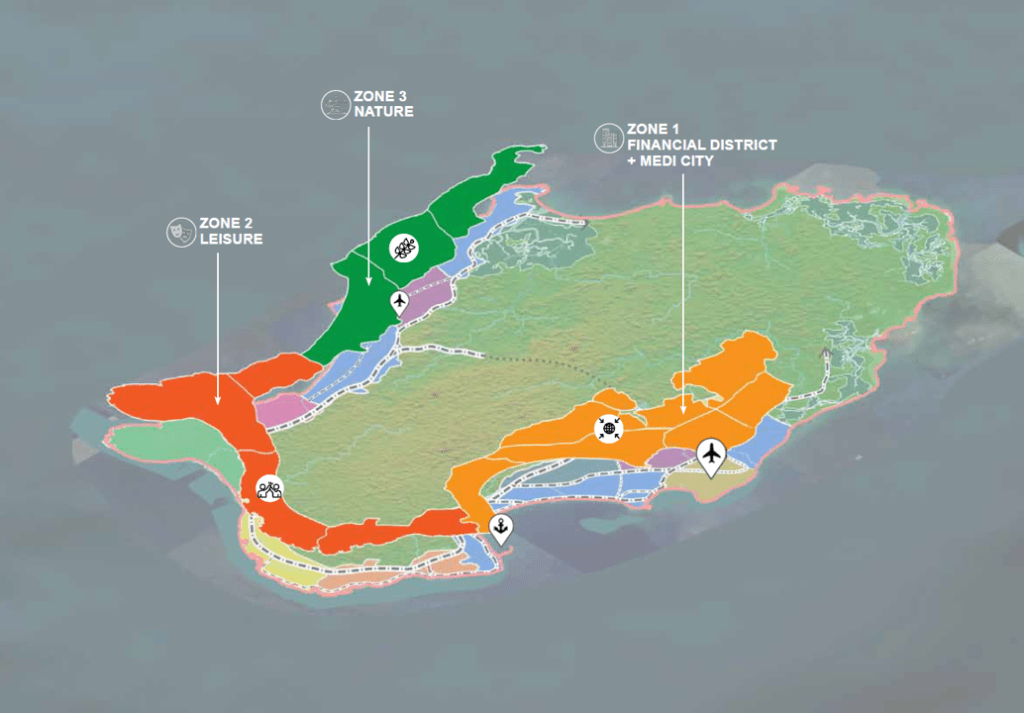
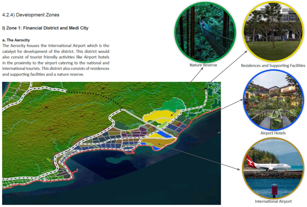
Airport development features heavily in a plan for tourism-oriented megaprojects on Little Andaman Island, the southernmost island of the Andaman archipelago. Graphics below, from the 58-page ‘Sustainable Development of Little Andaman Island – Vision Document’, show: Zone 1, on the eastern coast, featuring an Aerocity, housing an international airport, envisaged as ‘the catalyst for development of the district’; Zone 2, on the southern coast, including a Leisure Zone and Tourism SEZ (special economic zone) with casinos, theme park and beach hotels; Zone 3, on the western coast, a Nature Zone containing super-luxury resorts and hotels, with an airstrip for private charter flights.
Map of Little Andaman plan indicating developable areas
Little Andaman plan map showing 3 zones
Zone 1: The Aerocity is the catalyst for development
Sudden news of the plan, in January 2021, alarmed conservationists. The ‘Vision Document’, thought to have been finalised a few months previously but not in the public domain, is included in ‘A MONUMENTAL FOLLY: NITI Aayog’s Development Plans for Great Nicobar Island (An evolving archive of reports, information and documents)’, compiled by Panjaj Sekhsaria and published by Kalvpavriksh Environmental Action Group. The total project area is nearly 240 sq km, 35% of the island; the three zones would take up 107 kilometres of the island’s coastline. Development of this scale would have major impacts on indigenous people and the island’s unique biodiversity and forests. Little Andaman is home to the Onge tribe, living on the island for more than 50,000 years, the population dwindling since 1900. Now numbering an estimated 125 people the Onge tribe is categorised as one of India’s Particularly Vulnerable Tribal Groups (PVTG). According to the plan the Onge Tribal Reserve would be reduced by 31%; the Vision Document states that steps would be taken to relocate and protect Onge people but no detail is given. An anthropologist pointed out that bringing areas where Onge, with nomadic origins, do not live into the proposed development would still impact them, saying “the Onges have a close attachment with their territory be it inhabited or not”.
The Divisional Forest Officer of Little Andaman raised concerns that the major diversion of forest land for the project would cause irreversible damage to the island’s forests, entailing the loss of more than 2 million trees. An official source said there are over 2.4 million trees in the “vast tract of forests” in the areas where development is proposed. Removal of trees would cause topsoil erosion and reduce rainfall, impacting on the small area of the island with cultivable soil. Uprooting more than 2 million trees for the Little Andaman plan would also result in carbon emissions and carbon stock losses. Carbon pools were calculated for the four forest types in the development areas: nearly 136 sq km of Evergreen/Semi Evergreen and smaller areas of Deciduous, Swamp/Mangrove and Plantation forests. A study estimated that implementation of the ‘Sustainable Development of Little Andaman – Vision Document’ would result in carbon stock loss of 2,996.286 tonnes from five categories of carbon pools: 55% from woody debris and soil organic matter, 32% from above ground living biomass, 9% from below ground biomass, 3% from dead mass of litter and 1% from dead wood.
Nesting sites of Giant Leatherback Turtles, the world’s largest turtles growing over 6 feet in length, with many populations in precipitous decline, are threatened by the Little Andaman plan. South Bay and West Bay on Little Andaman are both high-intensity nesting sites and among the most important in the entire island chain. Along with other nesting beaches on the islands, the two sites are specifically mentioned as ‘Important Marine Turtles Habitats in India’ in the National Marine Turtle Action Plan. There are fears that implementation of the ‘vision’ would push the leatherback turtles to the brink of extinction. A 2019 report on a long-term monitoring programme at Little Andaman island identified previously unknown migratory routes of Great Leatherback Turtle nesting in the region, highlighting their dependence upon foraging and nesting sites that are thousands of kilometres apart. Nine tracked turtles traversed much of the Indian Ocean, as far southeast as Western Australia and towards the eastern coast of Africa. The turtle travelling the furthest, close to the western coast of Mozambique, covered 13,237km in 266 days; it was also the fastest, travelling an average of 49.8km per day.
More information about the Little Andaman plan has been published on EJatlas, the world’s largest, most comprehensive online database of social conflict around environmental issues: Little Andaman Development Plan
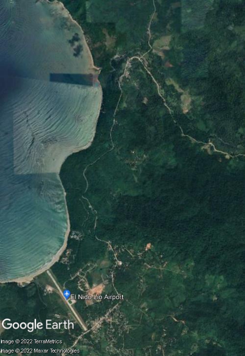
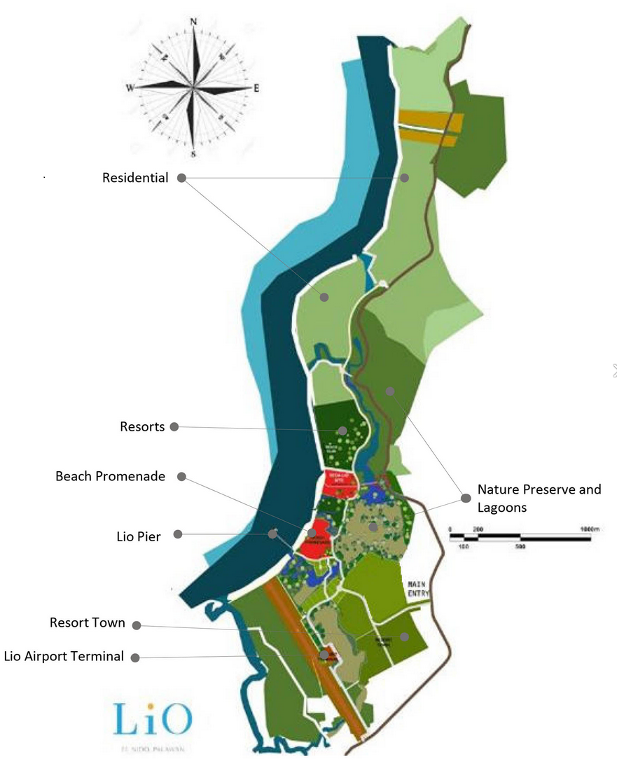
Lio Tourism Estate, a masterplanned luxurious development in El Nido, on the northern tip of Palawan – owned by Ayala, one of the largest conglomerates in the Philippines, and operated by one of its many subsidiaries, Ten Knots Philippines Inc. (TKPI) – encompasses a large 325-hectare site. As well as high-end hotels the resort contains its own private airport, Lio Airport, owned and operated by TKPI for the exclusive use of its aircraft. As with most airports worldwide the response to Covid-19 led to Lio Airport reducing operations, but by March 2022 about 600 passengers were flying in and out each day. AirSwift Philippines operates flights between Lio Airport and Manila. There is also a jetty port for visitors to embark on island-hopping boat trips. The tourism project, on a former copra (coconut) farm, began with construction of the airport and seaport to provide access, followed by accommodation and retail facilities. Shown below are satellite imagery and a site development plan published by a property firm.
But the Tagbanua Tandulanen Indigenous People (IP) claim that the project encroaches on their ancestral lands. In April 2021 their attorneys requested that the Department of Tourism (DOT) and Local Government Unit of El Nido cancel, revoke or deny applications for building permits and licenses for more than seven Ayala-owned businesses and projects in El Nido, including Lio Tourism Estate and Lio Airport. The IP group claimed ‘rampant and widespread’ proliferation of illegal transfers and conversion of their ancestral domain. On 15th March 2022, following reports of projects and activities that did not comply with Free and Prior Informed Consent (FPIC) requirements, the National Commission on Indigenous Peoples (NCIP) intervened in the land dispute, issuing a cease-and-desist-order (CDO) ordering temporary halt of projects in Barangays Libertad and Pasadeña. After issuing four notices to comply with the CDO NCIP issued a show cause order to TKPI on 13th February 2022. In March Tagbanua Tandulanen IP’s legal counsel said the group been sending letters to TKPI for two years without receiving a serious response and urged NCIP to maintain the CDO.
Extending northwards of the tourism estate developed area and Lio Airport is a 4.2 kilometre stretch of white sand beach, also part of the resort. In September 2017 the management of Lio Tourism Estate dismissed accusations that its recently opened upscale resort had blocked access to the public beach in front of it for residents of Barangay Villa Libertad. The issue stemmed from a complaint to the Palawan Provincial Board’s Environment Committee. A month previously Board Member Winston Arzaga said they had been asked by local officials to help resolve the issue, saying “The cause of it all is the access of local fishermen to their traditional fishing grounds which the Ayala management had somehow restricted.” A Safeguards Due Diligence Report for El Nido tourism development, prepared by the Tourism Infrastructure and Economic Zone Authority (TIEZA) for the Asian Development Bank (ADB), published in May 2021, includes notes of a consultation on fisheries management concerns and livelihood projects with Barangay Officials of Villa Libertad, which covers Lio beach, part of Lio Tourism Estate. Dwindling fish catch was the major fisheries issue identified by informants, resulting from overfishing and a reduced fishing area. Declining fish catch and reduced access to fishing grounds was also mentioned in relation to three other Ayala resorts in El Nido, on the islands of Miniloc, Pangulasian and Lagen.
More information about the land dispute and issues with access to fishing grounds related to Lio Tourism Estate and Lio Airport has been published on EJatlas, the world’s largest, most comprehensive online database of social conflict around environmental issues: Lio Tourism Estate and Lio Airport