New Research: Airport projects responsible for human rights violations and ecological destruction around the world

Map of Airport-related Injustice and Resistance

Interactive map documents 80 cases of airport-related injustice and resistance

A new interactive map documents cases of airport-related injustice and resistance around the world. All across the globe airport projects are generating serious conflicts and social and environmental impacts: land acquisition, displacement of people, destruction of ecosystems, local pollution and health issues. A new map based on scientific research presents 80 cases as detailed examples of the conflicts generated by airport projects around the world. The research also identified more than 300 cases of airport projects where there is evidence of conflict, that merit further investigation. Research began in 2018 and has been jointly conducted by the EnvJustice project of the Environmental Science and Technology Institute at the Autonomous University of Barcelona (ICTA-UAB) and the Stay Grounded network. 

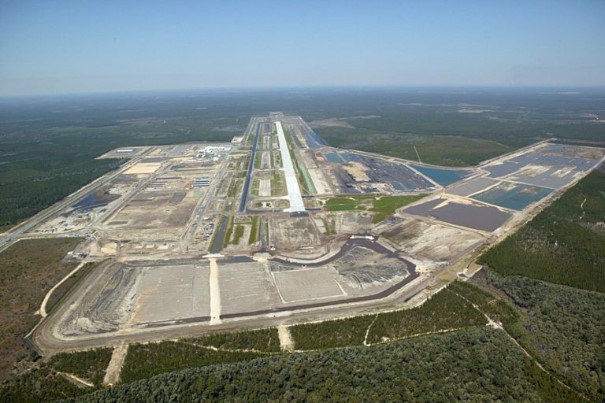
In many countries, airport planning, construction and expansion continues, in spite of the steep decline in air traffic since the beginning of the Covid-19 pandemic. All aviation expansion, wherever it takes place, contributes to the global problem of climate destruction. Aviation, being fossil fuel dependent and intensive, is a major and growing source of greenhouse gas emissions. By documenting a multitude of local struggles against airport projects the Map of Airport-related Injustice and Resistance contributes to a broad and diverse global movement for degrowth of aviation and transition to a just and sustainable mobility system.

Communities around the world struggle against eviction from their homes and farmland for aviation expansion, and to protect forests, wetlands and coastal ecosystems, our research shows. Our interactive feature map, the first of its kind, documents a multitude of airport-related injustices and inspirational resistance movements,” say Sara Mingorría of EnvJustice (ICTA-UAB) and Rose Bridger of Stay Grounded.

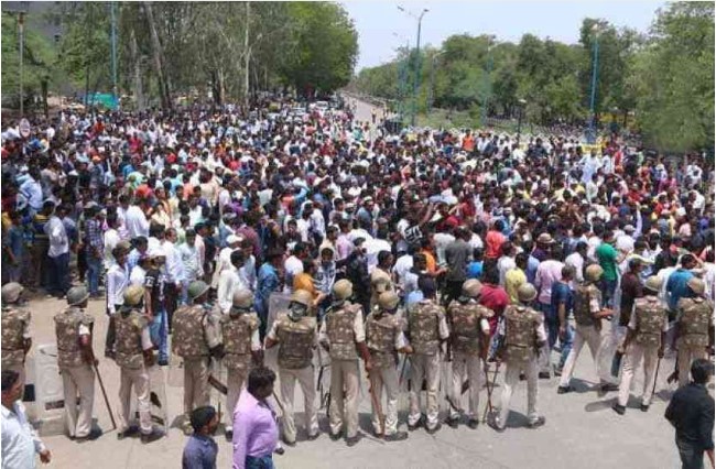
Many of the cases documented and analysed involve affected communities opposing  land acquisition for airport projects. In about half of those cases studied there were problems of land dispossession (50%) and displacement (47%). Many communities resisting displacement have suffered human rights violations and state repression: forced evictions, harassment, intimidation, arrests, imprisonment and violence. In around a third of the cases studied there were problems of repression (30%), militarization (29%) and the conflicts reached a high level of intensity (35.5%).

Site clearance for many airport projects also obliterates wildlife habitats and biodiversity. In 48 percent of the cases analyzed, problems of loss of landscape were registered, 41 percent involved deforestation impacts and 32 percent loss of biodiversity. 

The Map of Airport-Related Injustice and Resistance is a joint project by the EnvJustice (ICTA-UAB) and Stay Grounded. Information has been contributed by organizations, journalists, activists and academics. The research project is co-founded and coordinated by Rose Bridger (Stay Grounded/Global Anti-Aerotropolis Movement-GAAM/EnvJustice ICTA-UAB) and Sara Mingorría (Stay Grounded/EnvJustice ICTA-UAB); Yannick Deniau (Envjustice/GeoComunes) and Mira Kapfinger (Stay Grounded) joined the coordination team during the project. The 80 published cases are just the beginning of the mapping project. The research team anticipates that many more conflicts will be documented on the map as the project continues.

EJAtlas is an online database and interactive map documenting and cataloguing environmental conflict around the world. It started in 2011 and counted on the collaboration of hundreds of researchers and organizations. It is now coordinated by the ENVJUSTICE project at ICTA-UAB.

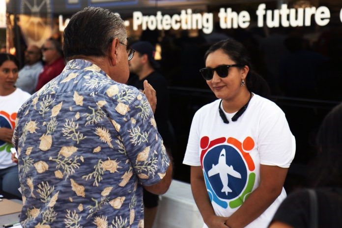
Stay Grounded is a network of more than 160 member organisations from all over the world, among them: NGOs, climate justice groups, indigenous organisations, labour unions and civil initiatives against airport noise and expansion. Together, they fight for climate justice and a fair reduction of aviation.

See the airport injustice cases on the Feature map

For more information see Voices from affected communities and overview of cases.

Map of Airport-related Injustice and Resistance, an introduction

Around the world communities are opposing new airports, expansion of existing airports and aerotropolis/airport city developments. A total of 67 cases have now been documented and are published on the Global map of aviation-related socio-environmental conflicts. Several cases and some of the emerging themes are outlined in this short introductory video. The map is a joint project of EnvJustice and the Stay Grounded Network.

Links to airport conflict cases mentioned in video:

Six aerotropolis-type projects added to socio-environmental conflicts map

Six more aerotropolis-type developments have been added to the Global Map of Aviation-Related Socio-Environmental Conflicts. All the projects – in the USA, Canada, Jamaica, India and China – have met with opposition from affected communities and/or environmental groups. In each case the site, or proposed site, covers a large land area. Launched in July 2019, the map is a joint project by the EnvJustice project and the Stay Grounded network. There are now 67 cases on the map. The new aerotropolis-type additions are listed below. Please click on the links to read the case reports which contain a wealth of information on the environmental and social justice impacts of the aerotropolis projects, the government bodies and firms that are responsible and how affected communities are fighting for their rights.

Northwest Florida Beaches Airport

In the USA, a private landowner stands to benefit from industrial, defence, retail and hotel development on land it owns around Northwest Florida Beaches Airport. Construction of the airport, located in the midst of forested wetlands providing a haven for black bears, red-cockaded woodpeckers and the endangered gopher tortoise, caused a decline in in spite of six environmental lawsuits. After the airport opened in 2010 a 404 hectare ‘airport city’ began taking shape on adjacent land. In December 2019 the landowner broke ground on a hotel next to the airport.

Northwest Florida Beaches Airport - aerial view
Aerial view of Northwest Florida Beaches Airport. Photo: Airport of the World, 25th May 2010 https://airportsworld.keypublishing.com/2010/05/25/first-new-us-airport-in-15-years/

Eastgate Air Cargo Facility

In California, a massive air cargo project, Eastgate Air Cargo Facility, is planned in San Bernardino, an area where residents already suffer health problems caused by high levels of air pollution from a concentration of logistics traffic. The site is 41 hectares and the project also entails new taxiways and an aircraft parking apron at San Bernardino Airport, construction of new driveways to the project site and two bridges. Hundreds of people have attended a church gathering and a hearing on the project. Workers, community and environmental groups, united under the banner SB Airport Communities, are campaigning for a ‘community benefit agreements guaranteeing well-paid, secure jobs along with measures to limit air pollution’.

Eastgate Air Cargo Facility, residents at FAA hearing
On 8th August 2019 hundreds of residents contributed their comments at Federal Aviation Authority (FAA) hearing on the air cargo project. Photo: Manny B Sandoval. Source: Inland Empire Community News http://iecn.com/hundreds-of-san-bernardino-residents-speak-out-at-faa-hearing-on-air-cargo-logistics-project-eastgate/

Hamilton Aerotropolis / AEGD

In Ontario, Canada, groundbreaking for Hamilton Aerotropolis, identified by authorities as a strategic priority in 2005 and subsequently re-named Airport Employment Growth District (AEGD), has commenced. A 555 hectare area of productive farmland around Hamilton Airport has been allocated to the project, which was approved in spite of local opposition, over many issues including the costs to taxpayers and availability of alternative sites on brownfield land, sustained over a long period.

Hamilton Airport Employment Growth District (AEGD) land use and infrastructure plan
Airport Employment Growth District (AEGD) land use and infrastructure plan. Image: City of Hamilton Airport Employment Growth District, Transportation Master Plan Implementation Update https://d3fpllf1m7bbt3.cloudfront.net/sites/default/files/media/browser/2017-08-04/aegd-update-transportation-assessment-report-2017.pdf

Vernamfield Aerotropolis and Logistics Hub project

In Jamaica communities are concerned they may face forcible eviction for the proposed Vernamfield Aerotropolis. A letter sent to residents in December 2019 gave residents the impression that the “stage had been set for a massive land grab”. The total site area is 2,428 hectares of land, some of which is among the most fertile in the country and had been used to cultivate sugarcane, is a key component of a broader Logistics Hub plan which spans the southeast coast of the island.

Vernamfield Air Cargo Logistics Facility, architect's impression
Vernamfield Aerotropolis is a key component of the Jamaica Logistics Hub project. Image: Jamaica Logistics Hub, 9th February 2016 https://www.youtube.com/watch?v=3v5hWd9tcLc

Shivdaspura Aero City

In the Jaipur District of Rajasthan, Northern India, residents of 20 villages have organized major protests against plans for an aerotropolis-type development called Shivdaspura Aero City, a ‘greenfield airport’ (on undeveloped land) along with hotels, shopping malls, cinemas, restaurants and a cargo hub. A series of protests by farmers affected by land acquisition began in January 2018. Landholders say they have been left in lurch” unable to develop or sell their land. The site is about 2,100 hectares and approximately 80,000 people are affected by land acquisition.

Protest against Shivdaspura airport project
January 2018 protest against Shivdsapura greenfield airport. Photo: Patrika https://www.patrika.com/jaipur-news/farmers-and-residents-warned-govt-on-greenfield-airport-project-2179532/

Sanya Hongtangwan International Airport, Hainan, China

Scheduled to cover an area of 26 square kilometers on an artificial island Sanya Hongtangwan International Airport is expected to be a gateway to Southeast Asia and the South China Sea. In addition to the airport and to support its operations an aviation economic zone, seaport operation area, international aviation CBD (central business district) and industrial zone will be built. Environmental activists raised concerns over damage to wildlife including coral reefs and Chinese white dolphins, listed as ‘vulnerable’ in the on the International Union for Conservation of Nature (IUCN) Red List of Threatened Species. They achieved a partial victory, halting the airport island reclamation project for more than two years.

Illustration of the proposed new Sanya airport.
Illustration of the proposed new Sanya airport. Image: Handout. Source: South China Morning Post https://www.scmp.com/news/china/economy/article/2119921/china-puts-massive-island-airport-project-hold-over-environmental


Global map of aviation-related socio-environmental conflicts and justice movements

A global map of socio-environmental conflicts and justice movements related to aviation-related projects includes 60 cases that have already been analyzed. The map provides a wealth of information on how people and the environment can be negatively impacted by new airports and expansion of existing airports. Affected communities contend with a multitude of injustices: eviction, land dispossession, loss of farmland and fishing grounds, destruction of ecosystems, construction work impacts and health damage from aircraft pollution and noise once airport projects become operational. More than 300 such cases around the world have been registered in the research project, conducted by the EnvJustice project and the Stay Grounded network.

Global map of aviation-related conflicts and environmental justice movements produced by The EnvJustice project of the Environmental Science and Technology Institute at the Universitat Autònoma de Barcelona (Autonomous University of Barcelona) ICTA-UAB and the Stay Grounded network
Map of aviation-related conflicts and environmental justice movements around the world

Several aerotropolis or airport city projects, i.e. substantial commercial and/or industrial development constructed or planned on land surrounding or adjoining an airport, are documented and analyzed. Examples include Kertajati Airport and New Yogyakarta International Airport in Indonesia, both of which involved forcible eviction of communities from several villages from their homes and farmlands. In Cambodia, the government has approved a plan for a new Phnom Penh Airport, one of the world’s largest airports by land area, along with an associated ‘airport city’. The proposed site, predominantly agricultural land, encompasses land that Kandal Stueng villages have resided on for two decades, including communally held wetlands. About 2,000 families could be affected and hundreds of people have protested against the development.

In India, Andal Aerotropolis is a private airport city development that was stalled by sharecroppers protesting delays in receiving compensation for land taken for the project. Landowners from seven villages in Purandar sustained resistance against loss of their homes and farmland for a new airport since the location of the project was announced in 2016. Then in 2018 it was reported that the state government was forming a consortium to drive investment in an ‘airport city’ around the airport. Villagers’ resistance against displacement from their farmland for Bhogapuram Aerotropolis, also referred to as an ‘aerocity’, succeeded in reducing the land area allocated to the project from 6,000 hectares to 1,122 hectares, along with securing higher compensation for a group of farmers.

A plan for a new airport on the Arial Beel wetlands in Bangladesh is an example of a aerotropolis-type megaproject that was halted by mass mobilisation. A vast swath of land had been earmarked for development, 10,117 hectares for the airport and an accompanying ‘satellite city’, and the farming and fishing livelihoods of thousands of people were set to be seriously affected with wetlands paved over. The government cancelled the project after major protests, the largest of which involved 30,000 people. In the Philippines, mangroves, coastal wetlands providing a vital habitat for many species and protection from erosion and flooding, have already been destroyed to make way for the proposed Bulacan Aerotopolis which threatens to destroy fishing livelihoods. Airport projects can entail deforestation. In Nepal, the proposed Nijgadh Airport, a massive 8,000 hectare aerotropolis, raises the prospect of over 2.4 million trees being felled.

A number of airport projects shown on the map are key components of tourism development schemes that are based upon aviation dependency. A proposed new airport on the Island of Fainu, in The Maldives, is accompanied by a plan for an adjoining hotel. The project would destroy a long stretch of white sand coastline, dense forest and agricultural land, the airport and hotel projects combined swallowing up much of the small island. Another example is the Philippine island of Sicogon where, in the aftermath of the devastation wreaked by Typhoon Yolanda, developers seized upon the opportunity for tourism development, the first phase of which includes an airport specifically for tourism along with beachfront accommodation. Disaster capitalism is also evident in the Caribbean island of Barbuda where land clearance for construction of a new airport, intended to support tourism growth in particular high-end resorts, began shortly after residents were evacuated following Hurricane Irma.

The map includes two major airports built to support fossil fuel projects. Uganda’s second international airport, Hoima Airport, currently under construction, is a key component of the 29 square kilometre Kabaale Petrochemical Industrial Park. With a 3.5 kilometre length runway, capable of accommodating the world’s largest cargo aircraft, it is envisaged that in its first phase of operations Hoima Airport will handle delivery of heavy equipment for the oil refinery on the site. In a similar vein, Komo Airfield, in the southern highlands of Papua New Guinea, has the country’s longest runway and was built for delivery of heavyweight and outsize equipment for the ExxonMobil led PNG LNG (liquefied natural gas) project.

A number of cases shown on the map involve allocation of larger areas of land than would be required for aviation operations, increasing the number of people potentially facing displacement due to land acquisition, but without clear information on what the excess land might be utilized for. For example, in Nigeria the Cross River State government intends to acquire 900 hectares of land for a proposed Obudu International Passenger and Cargo Airport and people have been evicted from their homes and farmlands. In a similar case in Nigeria, bulldozers arrived without warning to clear 4,000 hectares of farmland where crops including cocoa, palm trees and bananas were cultivated for a cargo airport in Ekiti. This airport project is one instance of a successful court case where affected people secured a court victory that halted the airport project. Also in Nigeria, about 5,000 people from 20 villages could be affected by a proposed Ogun cargo airport and hundreds of farmers protested against land-grabbing.

The map of aviation-related conflicts and environmental justice movements is an ongoing project in development coordinated by the EnvJustice (ICTA-UAB) project and the Stay Grounded network. In addition to the 60 airport-related cases already included, a great many further cases have been registered as meriting further investigation. A total of 300 cases have been registered. The information gathered for the global map has been provided by a wide variety of organizations, local collectives and academics. The research team is coordinated by Rose Bridger (Stay Grounded) and Sara Mingorria (ICTA-UAB). This already substantial database and interactive map related to airports is part of Ejatlas, the biggest global inventory of socio-environmental conflicts around the world. As of 11th July 2019 2,831 cases were registered on Ejatlas and this is anticipated to increase to 3,000 cases by the end of the year.