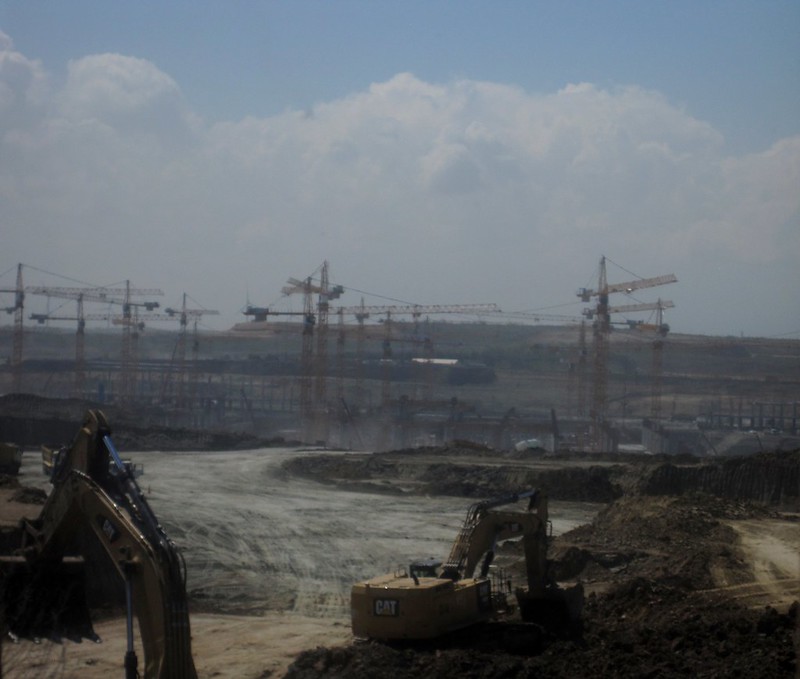
In November 2023 Cambodia’s State Secretariat of Aviation (SSCA) announced that construction of Dara Sakor Airport (Cambodia’s fourth international airport after Phnom Penh Airport, Siem Reap Airport and Sihanouk Airport) was in its final stages. Dara Sakor Airport has been built to serve a gigantic tourism-oriented economic zone, the 451 square kilometre Dara Sakor project encompassing about one-fifth of Cambodia’s coastline. The Dara Sakor developer, Coastal City Development Group Ltd., calls the project ‘Coastal City’ and its website has pictorial maps indicating the many components of the project such as Dara Sakor Airport, a resort, tourism zone, golf courses and a port. The China-Global South Project reflected on the Dara Sakor project in 2023. Of all the anticipated infrastructure only the airport was completed. Yet the project continued with ‘considerable support from the government’. BBC reporters visiting Dara Sakor in September 2023 described unfinished roads and buildings as a stark contrast with ‘dazzling brochures for potential investors’.
Pictorial map of Dara Sakor project including tourism zone, resort, golf courses, development zone and Dara Sakor International Airport. Source: Coastal City Development Group Ltd.
Thousands of people have been forcibly displaced from their homes for the Dara Sakor project, losing their farming and fishing livelihoods. There have been many protests against eviction and inadequate compensation, in many instances met with repression. Unrest dates back to the inception of the project in 2008 when 360 sq km of land in the Botum Sakor and Kiri Sakor districts in the Koh Kong Province was reclassified as state-owned land. A 99-year lease contract was signed with Union Development Group (UDG) of China. Cambodian Human Rights and Development Association (Adhoc) reported that affected communities were not consulted about the project, some only becoming aware when officials arrived to measuring land. In 2011 the project site grew to 451 sq km when UDG was granted an additional 91 sq km land concession to develop a water reservoir and hydropower. During 2011 UDG began dismantling and burning down some villagers’ houses and destroying productive trees.
A key protest took place in February 2014 when about 140 people blocked the road to UDG’s offices leading to a clash with 40 UDG security guards and six soldiers carrying AK-47 rifles. Kiri Sakor District Governor said district authorities had ordered about 100 families to vacate their land for the Dara Sakor project’s hotels, golf courses and an airport. By September 2014 5,791 people had moved to a relocation site where they lacked access to former farming and fishing areas and suffered many problems including poor quality housing damaged by wind and rain, limited water that did not meet national standards, lack of electricity and health care facilities. Reports of destruction of houses and productive trees emerged again in 2018. In april April Koh Kong Provincial Court heard testimony from 13 families claiming that 60 UDG guards had burned their productive trees, seeking compensation for loss of cassava, jackfruit, mango, rubber and coconut crops.
On 27th May 2019 about 20 residents protested in front of the Chinese Embassy in Phnom Penh, calling for resolution of the 11-year land dispute. A report by the Community Legal Education Center stated that 1,143 families were forced to vacate about 100 sq km of land in the first five years fo the project but many families had resisted and fought for rights to the land. Four villagers were detained for 12 hours on 29th September 2020, after camping outside Koh Kong Provincial Hall calling for action over the 12-year land dispute with UDG. A year later 1,333 families rejected compensation offers of between 1 and 3.5 hectares and said they would fight to remain on their land. Protests against compensation offers continues into 2022; some declined the offer as it was insufficient and the village the government wanted to relocate people to was 100 km away and lacked infrastructure.
In June 2023, just four months before SSCA’s announcement about construction of Dara Sakor Airport entering its final stages, there was yet another protest by people affected by displacement for the Dara Sakor project. A group of villagers involved in a Dara Sakor related land dispute attempted to travel to Phnom Penh to submit a petition at the Ministry of Justice, but were met with a police roadblock. Eleven villagers were arrested, forced into a truck, returned to Koh Kong and charged with criminal incitement. Radio Free Asia reported that authorities threatened further arrests after about 20 villagers gathered outside the offices where the 11 people were being detained. Human rights organization Licadho said the protesters had not caused any social disorder and that police had been sent to the the area where many of them lived.
For more information including references for all source material see the case study on EJAtlas, the world’s largest, most comprehensive online database of social conflict around environmental issues – Dara Sakor project, Cambodia.
Airport development features heavily in a plan for tourism-oriented megaprojects on Little Andaman Island, the southernmost island of the Andaman archipelago. Graphics below, from the 58-page ‘Sustainable Development of Little Andaman Island – Vision Document’, show: Zone 1, on the eastern coast, featuring an Aerocity, housing an international airport, envisaged as ‘the catalyst for development of the district’; Zone 2, on the southern coast, including a Leisure Zone and Tourism SEZ (special economic zone) with casinos, theme park and beach hotels; Zone 3, on the western coast, a Nature Zone containing super-luxury resorts and hotels, with an airstrip for private charter flights.
Map of Little Andaman plan indicating developable areas
Little Andaman plan map showing 3 zones
Zone 1: The Aerocity is the catalyst for development
Sudden news of the plan, in January 2021, alarmed conservationists. The ‘Vision Document’, thought to have been finalised a few months previously but not in the public domain, is included in ‘A MONUMENTAL FOLLY: NITI Aayog’s Development Plans for Great Nicobar Island (An evolving archive of reports, information and documents)’, compiled by Panjaj Sekhsaria and published by Kalvpavriksh Environmental Action Group. The total project area is nearly 240 sq km, 35% of the island; the three zones would take up 107 kilometres of the island’s coastline. Development of this scale would have major impacts on indigenous people and the island’s unique biodiversity and forests. Little Andaman is home to the Onge tribe, living on the island for more than 50,000 years, the population dwindling since 1900. Now numbering an estimated 125 people the Onge tribe is categorised as one of India’s Particularly Vulnerable Tribal Groups (PVTG). According to the plan the Onge Tribal Reserve would be reduced by 31%; the Vision Document states that steps would be taken to relocate and protect Onge people but no detail is given. An anthropologist pointed out that bringing areas where Onge, with nomadic origins, do not live into the proposed development would still impact them, saying “the Onges have a close attachment with their territory be it inhabited or not”.
The Divisional Forest Officer of Little Andaman raised concerns that the major diversion of forest land for the project would cause irreversible damage to the island’s forests, entailing the loss of more than 2 million trees. An official source said there are over 2.4 million trees in the “vast tract of forests” in the areas where development is proposed. Removal of trees would cause topsoil erosion and reduce rainfall, impacting on the small area of the island with cultivable soil. Uprooting more than 2 million trees for the Little Andaman plan would also result in carbon emissions and carbon stock losses. Carbon pools were calculated for the four forest types in the development areas: nearly 136 sq km of Evergreen/Semi Evergreen and smaller areas of Deciduous, Swamp/Mangrove and Plantation forests. A study estimated that implementation of the ‘Sustainable Development of Little Andaman – Vision Document’ would result in carbon stock loss of 2,996.286 tonnes from five categories of carbon pools: 55% from woody debris and soil organic matter, 32% from above ground living biomass, 9% from below ground biomass, 3% from dead mass of litter and 1% from dead wood.
Nesting sites of Giant Leatherback Turtles, the world’s largest turtles growing over 6 feet in length, with many populations in precipitous decline, are threatened by the Little Andaman plan. South Bay and West Bay on Little Andaman are both high-intensity nesting sites and among the most important in the entire island chain. Along with other nesting beaches on the islands, the two sites are specifically mentioned as ‘Important Marine Turtles Habitats in India’ in the National Marine Turtle Action Plan. There are fears that implementation of the ‘vision’ would push the leatherback turtles to the brink of extinction. A 2019 report on a long-term monitoring programme at Little Andaman island identified previously unknown migratory routes of Great Leatherback Turtle nesting in the region, highlighting their dependence upon foraging and nesting sites that are thousands of kilometres apart. Nine tracked turtles traversed much of the Indian Ocean, as far southeast as Western Australia and towards the eastern coast of Africa. The turtle travelling the furthest, close to the western coast of Mozambique, covered 13,237km in 266 days; it was also the fastest, travelling an average of 49.8km per day.
More information about the Little Andaman plan has been published on EJatlas, the world’s largest, most comprehensive online database of social conflict around environmental issues: Little Andaman Development Plan
Construction of an airport on the island of Barbuda began without residents’ approval. A larger land grab looms; moves are afoot to revoke residents’ collective tenure and allocate land to private investors.
On the night of 6th September Hurricane Irma, the most powerful hurricane ever recorded over the Atlantic Ocean, an unprecedented Category 5, made landfall on the small Caribbean island of Barbuda. 185 miles-per-hour winds wreaked havoc. A two-year old child was killed, land was flooded and shorn of trees, homes were left without roofs and walls or completely flattened and the island’s road, energy and communications infrastructure were destroyed. An estimated 90 per cent of buildings were damaged. Two days later all of Barbuda’s 1,800 residents were forcibly evacuated, ferried to Antigua which only suffered minor damage.
Two and a half months after the catastrophic storm most Barbudan residents remained with relatives and friends or in impromptu shelters such as a cricket stadium in Antigua, or abroad. Only a small number of islanders were allowed to return, for a few hours at a time. Efforts to rebuild houses were piecemeal. People were patching up roofs using plywood and corrugated iron salvaged from the wreckage. Hardly anything had been done to re-establish essential services. Water and electricity supplies had not yet been restored; returned residents relied on generators and desalinated water provided by humanitarian aid organizations. Schools and the hospital remained closed. But bulldozers had been working day and night for weeks, flattening land in preparation for construction of an international airport.
In a Channel 4 report Leslie Thomas QC said development of the airport is unlawful as it had not been approved by the Barbuda Council and consultation with the Barbudan people had not taken place. Work on the airport, which will have serious negative ecological impacts on the coral fringed island renowned for its seabird colonies, had commenced without the requisite Environmental Impact Assessment (EIA). Already, forest, wildlife habitats and land used for livestock grazing had been destroyed for the runway.
Bulldozing land in preparation for construction of the new airport is evidently so highly prioritized by the government that it began even before Barbuda’s existing small airport had been re-fenced and resumed operations. Prime Minister of Antigua and Barbuda Gaston Browne dismissed residents’ legitimate concerns that the new airport is evidence of a land grab. His text message to Channel 4 in response to coverage of the issue directed a string of insults at citizens: “The deracinated Imbeciles, Ignorant elements, say that by building Barbudans an airport, we are stealing their land. 😂😂😂 These are what we call dunce elements.”
A land grab paving the way for privately-owned resorts
Prime Minister Gaston Browne is exploiting the chaotic after-effects of Hurricane Irma to attempt to erode Barbudans’ land rights. Within days of the disaster he proposed that Barbudans returning to their homes buy freehold title deeds to their land for $1, which could be used as collateral for bank loans to get mortgages to rebuild their homes, claiming that creating an “ownership class” would be “empowering”. Barbudans objected that this would force them to buy land they have owned collectively for nearly two centuries, since 1834, when Britain abolished slavery in its colonies.
Post-Irma disarray is being used to launch the latest in a series of attempts to undermine the 2007 Barbuda Land Act, which confirms that Barbudans share common title to the land and requires their consent for commercial development. The entire island is owned collectively and managed by an elected council. As co-owners citizens have rights to utilize the island’s resources, including for grazing animals, hunting and fishing. Individual citizens, whether resident on the island or not, have the right to a plot of land for a house, to farm and for commercial enterprise. Browne refuses to recognize Barbudan’s communal land rights. He refers to islanders as “squatters” in a New York Times mini-documentary showing how people’s difficulties in retaining shared land rights are compounded by relentless struggles to retain community cohesion and rebuild their own lives.
Barbuda resident and marine biologist John Mussington maintains that the line being put out, that Barbudans do not have the means to rebuild their homes, is a myth that is being perpetuated to justify a land grab. People managed to rebuild after a hurricane in 1995. Under the current land tenure system residents are not burdened with mortgages and high land prices, so they are able to channel their resources directly into rebuilding their homes. Furthermore, there have been generous donations from international aid agencies and there will be a substantial payout from an OECD insurance scheme that Barbuda is a member of.
Collective tenure is not a barrier to recovery
Liz Alden Wily, an independent land tenure specialist, maintains that if the government succeeds in forcing Barbudans to buy title deeds to their land this will result in many citizens losing their property. Without a sufficient and steady income – difficult for people to secure when their lives have been severely disrupted by the hurricane – people may not be able to secure loans or will not be able to afford the repayments, a plight that would force them into distress sale of their plots. She refutes Browne’s insistence that individual, private land ownership is a precondition of post-Irma recovery and the only way for Barbudans to secure bank loans for reconstructing their houses. Collective title is not a barrier to securing a mortgage. Another option would be for the government to follow successful examples of establishing forms of credit, such as a credit union, which would not place people’s homes, often their main or only asset, at risk.
The privatization agenda being pushed by Browne’s government will enable developers to acquire land, in particular lucrative beach-front parcels, at low prices. In marked contrast with many Caribbean islands, including Antigua, where tourism revolves around all-inclusive beach resorts and cruise ship ports, tourism on Barbuda is small-scale. The vast majority of the coastline remains undeveloped, the beaches remain unspoiled. Residents have approved some tourism projects, maintaining a high degree of community ownership and control. Weakening the Barbuda Land Act would enable land purchase by Antiguan and foreign interests, to establish privately owned resorts. Browne admits that the airport will open up Barbuda for investors and is pushing for a cruise ship port on the island as well as an airport, to support tourism growth.
Dispossession and disaster capitalism
A land grab is looming in Barbuda, and it is bigger than the new airport and citizens’ plots of land. Imposition of individual freehold title would result in Barbudans losing their rights to most of the island. Only a minority of the land is designated as housing, farming and commercial plots; the majority of the land is long established as a communal resource which is of particular importance to poorer islanders’ livelihoods. Removal of Barbudans’ rights to this land would convert it to easy pickings for investors. Furthermore, Barbudans without land would no longer have rights to acquire plots, and nor will islanders’ descendants. Alden Wily said “The government is asking Barbudans to surrender collective ownership of the whole island for just a few parcels of land in (the capital) Codrington”. Back in October she had warned that:
“Repeal of the Barbuda Land Act would free up most of the island for allocation to investors. Overall, it is difficult to see this move as other than a classical land grab by the stronger elite, and the end result of which could well turn the island principally into foreign-owned resorts.”
Kendra Beazer, featured in the New York Times film and a member of Barbuda Council and the Barbudan People’s Movement, slammed the government’s opportunistic moves to change land tenure laws, while its people are traumatized, scattered and scrambling to rebuild their lives, as an example of ‘disaster capitalism‘: the exploitation of citizens’ vulnerability in the wake of crises – including extreme weather, war and terrorist attacks – to consolidate state and corporate power in order to drive through neoliberal policies of privatization, austerity and deregulation. Naomi Klein explores the imposition of these so-called ‘free market’ policies over the course of four decades, in the aftermath of catastrophic events including Hurricane Katrina and the 2004 tsunami in the Indian Ocean, in her book The Shock Doctrine: The rise of disaster capitalism, published in 2007. She commented on the post-Irma construction of Barbuda airport on Twitter:
On 12th December, in a brazen attempt to subvert democracy, the first reading of the Barbuda Land (Amendment) Act took place in parliament. The Bill, seeking to repeal and replace the Barbuda Land Act and dismantle the communal tenure system, did not appear on parliament’s agenda until moments before its introduction under an accelerated review process. Leslie Thomas said the act was tabled with no consultation whatsoever. Many Barbudans – returners to the island, the disapora, and their supporters – moved to resist the land grab enabling legislation. A petition against the Act has already garnered over 2,500 signatures and dozens of people joined a picket outside parliament.
An injunction seeking permission for a judicial review of the government’s attempt to expedite amendments to the Barbuda Land Act has been heard by the Antigua and Barbuda High Court of Justice, presented by Leslie Thomas. Broader resistance is gathering momentum with formation of the Barbuda Silent No More movement, working to strengthening Barbudans’ voices as they work to protect communal land rights, determine their own future and conserve Barbuda’s heritage, culture and environment.
But the airport land grab is progressing. John Mussington, who refused to leave the island after Hurricane Irma struck because he suspected underhand motives for the evacuation, and filmed bulldozing of land for the new airport that was used in the Channel 4 report, now reports that a huge area of land is being cleared and parceled up. The government claims that the land clearance is for an airport, but it is clear that what is taking shape is not just an airport. Water and electricity services have still not been restored, schools and the hospital remain closed. He says the “attack on our land tenure system is unconscionable” and it is clear that “powers that be” want Barbudans out of the way with the intention of a creating a “private island” for the enrichment of real estate speculators.
Regulation to pave the way for a mega-resort
Erosion of Barbudan’s land rights, and imposition of major tourism developments, already looms with government support for a mega-resort called ‘Paradise Found‘. On the site of an abandoned hotel project, islanders had cautiously welcomed proposals for redevelopment, but became concerned when the government approved extension of the 251 acre footprint of the resort by granting a lease for an additional 140 acres. Funded by famous film actor Robert de Niro and Australian billionaire businessman and investor James Packer, the plan for the $250 million luxury beachfront resort features upmarket cottages each with a private pool and a yacht marina, along with an airport.
A referendum approved the Paradise Found project, but only by a narrow majority, and the Barbuda People’s Movement challenged the result as unlawful on the basis that non-Barbudans were permitted to vote. The government pushed through laws to facilitate the resort project. In 2015 the Antigua and Barbuda parliament passed the Paradise Found (Project) Act, the provisions of which specifically support development of the resort, exempting the De Niro-Packer project from time limits on development and granting a 198 year lease along with the right to freehold tenure should this become instantiated in law. The debate on the bill attracted 400 protesters; critics warned that it stripped away the rights of the elected Barbuda Council to consider and approve large-scale property deals on the island. The Paradise Found Act also doled out a cluster of tax breaks for the two business partners; on corporate income, dividends, stamp duty and property.
The future of the Paradise Found project is uncertain, protest and litigation have bogged it down. Barbudans may well succeed in fending off the Barbuda Land (Amendment) Act which threatens to open the gate to a multitude of privately-owned resorts. The drive to revoke collective tenure goes against the grain of a positive global trend. Around the world thousands of communities have secured legal rights to shared land tenure, controlling, regulating and leasing commonly held property as they see fit. In 2018 a global declaration on the rights of the world’s rural communities, making collective ownership and governance a founding right, will be presented to the United Nations Assembly.
An 80 square kilometre aerotropolis is planned in Nijgadh, Nepal. The projects entails displacement of 7,380 people and felling of 2.4 million trees.
A major aerotropolis is planned in Nijgadh, in the Bara District in southeastern Nepal, 175 kilometers south of Kathmandu. If the megaproject proceeds as planned as many as 2.4 million trees will be felled, and 7,380 people living in the Tangiya Basti settlement within the site will be displaced. The government has repeatedly stated that Nijgadh Airport with a 80 square kilometer site, will be the largest, by area, in South Asia. An airport city adjoining the airport is planned. The map below shows the proposed Nijgadh Airport boundary as reported in the Nepal Gazette on 5th June 2015. The site is between two braided rivers, Pashah to the west and Bakiya to the east. The northern boundary is the Mahendra Highway between the two rivers. Most of the site, about 90 per cent, is densely forested land, predominantly consisting of Shorea robusta trees, which are also known as Sal or Sakhua. The settlement in the middle of the airport site, where about 7,380 residents living in 1,476 households face eviction, is called Tangiya Basti.
Nijgadh Airport site boundary , as described in Nepal Gazette, 5th June 2015
A series of government announcements underlined determination to pursue the project. In June 2014 the government emphasized determination to attract investors, reportedly ‘preparing to complete the pre-construction works to spare the investors all the hassles whether the government, private sector or foreign investors invest on the project’ as preparations were being made to fence off the land. January 2016 saw another high level push to commence construction of Nijgadh airport. The Ministry of Culture, Tourism and Civil Aviation (MoCTCA) was instructed to begin land acquisition, site clearance and resettlement of affected people and the Ministry of Soil Conservation was directed to fell trees and clear the site for the construction of primary and access roads to the airport site within two months.
It appears that a confirmed investor in the airport has proved elusive. Public funds will be used to develop the project. On 24th May 2016 the government allocated US$46.4 million for the construction of Nijgadh Airport, for land acquisition, resettlement of displaced people, environmental impact assessment and preparation of a detailed project report. The Tourism Minister said the project would be developed in phases, beginning with a single runway facility with capacity for 20 million passengers annually, with the accompanying airport city to be constructed at a later stage. In January 2017 the government assigned preparatory work on Nijgadh Airport to the Nepal Army, tasking it with building a perimeter road and an access road to the area earmarked for the runway, and clearing trees to make way for construction.
600,000 trees could be felled to fund Nijgadh Airport construction
By May 2017 forest earmarked for Nijgadh Airport remained unfelled, but vast numbers of trees could be transformed from an obstacle to airport construction into a source of funding for it. A news article entitled ‘Money grows on trees for Nijgadh airport project‘ reported a statement by officials that a vast swathe of the forest, about 600,000 trees, will be felled for the airport. The market value of the lumber was estimated at nearly US$581 million, which would be sufficient to pay for half of the US$1.172 billion construction costs for the first phase of the airport. The Forest Ministry permitted the Tourism Ministry to conduct an EIA (environmental impact assessment) on the condition that 25 trees are planted for every tree that is cut down.
Tourism Ministry officials pointed out that tree planting on this scale this would be difficult to implement, as felling 600,000 trees would require the planting of more than 15 million saplings. The suggestion that 15 million trees could be planted is more than merely ‘difficult’; it is completely unfeasible. Any such mega tree plantation could not replace the rich biodiversity of an long-established forest ecosystem and an enormous land area would be required, inevitably entailing the wholesale obliteration of an existing ecosystem in order to plant such a huge number of trees.
2.4 million trees could be felled for 80 square kilometre aerotropolis
Subsequent announcements in July and August 2017 threaten the felling of even more trees for Nijgadh Airport, over 2.4 million, to make way for the full 80 square kilometer aerotropolis. The first phase of the airport will spread over between 1,000 and 2,000 hectares, and CAAN has assigned the Nepal Army to clear trees at the airport construction site and to build access and perimeter roads. The government has allocated US$14.6 million for the project this fiscal year with CAAN setting aside an additional US$29.2 million to pay for initial works, if required.
A short video of the forest at risk of being destroyed for Nijgadh airport was posted on Twitter, by Milan Dhungana, who commented: “It’s very hard to believe that this beautiful dense forest is soon to be vanished to give way to a new airport.”
It’s very hard to believe that this beautiful dense #Sal forest is soon to be vanished to give way to a new airport. pic.twitter.com/6K8YVrnrRC
Residents of Tangiya Basti, 7,380 people living in the settlement in the midst of the forest land earmarked for Nijgadh aerotropolis, face displacement. In June 2014 MoCTCA was attempting to settle disputes over compensation for land acquisition and people’s demands for resettlement arrangements. By March 2016 the task of collecting land details had been completed, with land valuation about to commence, along with issuing public notices for land acquisition. Land had been categorized as under individual ownership, public land and ‘unidentified ownership’, the majority belonging in the latter category. A video shows the Civil Aviation Authority of Nepal (CAAN) sign erected at the Nijgadh Airport site.
A 35-day notice was published for landowners to apply for compensation in March 2017. The amount of compensation for land acquired for the airport had been confirmed and the notice required landowners to harvest their crops within a month, prohibiting them from cutting any trees or plants. But compensation is only available to a minority of residents who have recognized land ownership. A September 2016 project report by Tourism Secretary Prem Kumar Rai stated that 110 households were eligible for compensation, with between 80 and 85 of these households agreeing to the compensation and the remainder reluctant to accept the government’s offer. The majority of residents facing eviction, about 1,400 households, have been categorized as ‘squatters’. Chief of the airport project, Hari Adhikari, said that nothing had been done to resettle the ‘squatters’ living on the construction site. In July 2017 the Himalayan News Service reported that the government’s preparations to acquire land for Nijgadh Airport had left residents of the Tangiya settlement, about 7,380 people, fearing their displacement and in a state of panic over their resettlement.
Tangiya Basti residents are struggling for new homes and livelihood opportunities. The Tangiyabasti Stakeholders Committee stated that construction of the airport had made their future uncertain and held a press conference where they demanded rehabilitation. Residents facing eviction are insisting upon replacement land and food supplies, provision of water, electricity and education in the place where they will be relocated, and one job for each of the affected families. Chair of the Tangiyabasti Stakeholders Committee, Ramesh Kumar Sapotka, said that they would refuse to vacate the area unless their demands were addressed.
Tangiya Basti residents have been living in limbo for years, knowing they face eviction for the long delayed airport, which was proposed 20 years ago. The settlement was established by the government for flood victims in 1975 and the majority of people living there are from the marginalized Tamang ethnic group. For more than 40 years the government has failed to fund essential services for their established settlement, or to support their own efforts to develop these services. Tangiya Basti residents lack electricity, a reliable drinking water supply, electricity and roads. Construction of schools has been cancelled leaving pupils with a dangerous seven kilometer walk through dense forest to get to classes, with the risk of being trampled on by wild elephants that roam freely in the area. Many locals have to go to a neighboring town to make telephone calls and walk for several hours to reach healthcare facilities.
Fast-track to destruction
A 76 kilometer road, a ‘fast-track highway’, linking Nijgadh Airport with Kathmandu, has been on the drawing board since 1996. Reducing the travel time to the capital city to one-hour, is considered essential for the feasibility of the airport, but the road megaproject has also been plagued with delays. A Detailed Project Report (DPR) for the ‘fast-track’, a four-lane mega-highway, crossed by seven bridges and expanding to six lanes, was completed in August 2015.
Preparatory work for construction of the road was fraught with technical problems. The Nepal Army began excavation works without regard to the specifications for a four-lane expressway and the challenges of construction works on steeply sloping terrain, which could cause landslides. After years of delays the foundation stone for the expressway was laid on 28th May 2017, and the project handed over to the Nepal Army which will oversee construction. In the interim the road has fallen prey to the cost escalation common to megaprojects around the world. Over a seven year period the estimated construction cost of the expressway has doubled to over US$1 billion.
Megaproject mania, misplaced priorities
The Nepal government’s relentless pursuit of Nijgadh Airport and the fast-track continues in the face of criticism that the projects are draining funds from other regions of the country. Meanwhile, other megaprojects languish incomplete and have fallen far behind schedule, such as a 28 kilometer tunnel to bring water from Melamchi to Kathmandu and transmission lines. Massive deforestation looms to clear the designated site for the airport even though funding for construction has not been secured. Successive administrations have put forward different plans for financing Nijgadh Airport. As late as August 2017 no decision has been made on funding. Two financial models have been put forward. BOOT public-private partnership (PPP) would involve foreign investment or private financing. Alternatively, the government would develop the project under the engineering, procurement, construction and finance (EPCF) model.
Megaproject mania, in particular massive government expenditure on a gigantic airport, multilane highway and aerotropolis, is a serious case of misplaced priorities in one of the world’s poorest countries. Nepal is still reeling from a devastating earthquake on 25th April 2015 which killed nearly 9,000 people and destroyed over 700,000 homes. Political infighting has delayed reconstruction and, in spite of billions of dollars pledged in aid, outside of Kathmandu the majority of affected families are still living in desperate conditions, in tents or makeshift shelters, enduring harsh winter weather and heavy monsoons. In these circumstances, spending vast amounts of public money on a mega-airport that would displace over 7,000 people is nonsensical.
Residents of Sukamulya village in the regency of Majalengka, a predominantly rural administrative area in the West Java province, Indonesia, are resisting eviction for Kertajati Airport. They are fighting for their land and water, blocking officials from entering the village to measure land in order to acquire it for the airport. The stand-off between officials and villagers refusing to be displaced, which began on 8th August, is the latest chapter in twelve years of resistance. A plan for a major airport, taking up a land area of approximately 50 square kilometres, first surfaced in 2004.
The Front Perjuangan Rakyat Sukamulya (FPRS), which translates as the Sukamulya People’s Struggle Front, was formed to resist eviction for the airport and the campaign is supported by Indonesian land rights and agrarian reform NGO Konsorsium Pembaruan Agraria (KPA). As shown in a video by FPRS, hundreds of people are participating in the protests and women are playing a leading role. Sukamulya is bedecked with flags and banners. Road entrances to the village are being monitored day and night and blocked with tyres, preventing officials accessing land in order to measure it for the airport. A protest camp with a communal kitchen, using food harvested in Sukamulya and donated by villagers, helps maintain high spirits.
At the time of writing the blockade has been successful and the latest in several attempts at land measurement have been cancelled. Hundreds of residents blocked entry to the village, succeeded in holding back officials from the land agency, Badan Pertanahan Nasional (BPN) and police. On 1st September, hundreds of Sukamulya residents stated that they were ready to die in order to defend their land and demanded that the government treat them humanely. The action has garnered support from students and Majalengka farmers’ organization. Affected villagers are determined to avoid the fate of people whose land has been acquired for the airport; the level of compensation offered was insufficient for them to afford to buy land and build a house in nearby villages. But the government remains determined to impose the airport project. On 5th September, KPA reported that BPN was preparing to make another attempt to enter Sukamulya village to undertake land measurement, and that officials would be accompanied by a greater number of security officials.
12 years of resisting eviction for the airport
Over the twelve years since announcement of the Kertajati airport project there have been a great many protests. On 8th June 2007 hundreds of demonstrators rallied to protest against the threat of eviction facing at least 16,000 people from five villages. Speeches were followed by a mock trial of the Majalengka Regent, the head of the Regency. Demonstrators objected to lack of information about the airport project, including how much compensation they would receive from the government, and refused to be relocated.
Some residents have accepted compensation for their land and moved away, but the majority refuse to give land for the airport without fair land acquisition respecting their rights to accurate land measurement and appropriate compensation. Many reject the airport project entirely and are united in their refusal to give up their land for it. KPA maintains that the majority of the population of the 11 affected villages have opposed acquisition of their land and construction of the airport.
The FPRS video above documents a major protest on 25th January 2016. Hundreds of residents and their supporters rallied in front of the Majelengka land office and State Attorney office, arriving for the march in a procession of motorbikes and trucks carrying banners and posters. Rousing speeches voiced residents’ opposition to the construction of Kertajati Airport and the land acquisition process, protesting that it was not being conducted according to regulations. Villagers vowed that they would remain in Sukamulya. Hundreds of residents marched again on 22nd February 2016, demanding that delayed land compensation be paid to nearly 400 families and outraged that members of the community were being intimidated by officials. A video of the protest by the Majalengka police shows the presence of a large number of officials maintaining tight control of the demonstrators.
On 1st March 2016 the International Land Coalition (ILC) reported that conversion of the land for Kertajati Airport had resulted in the eviction of 10 villages. A tweet by ILC Asia showed a photograph of Iwan Nurdin, Secretary General of KPA, addressing a large group of evicted farmers from the affected villages.
On 2nd May 2016 hundreds of Sukamulya residents, supported by FPRS and KPA, rallied at the district government office demanding a fair land settlement. Speakers at the rally protested dishonesty in the land acquisition process including an inaccurate EIA (Environmental Impact Assessment) which stated that crop yields are far lower than are actually harvested. Intimidation by officials had forced some residents to flee from their homes and some had been detained.
Sukamulya villagers and their supporters defending homes and farmland from land acquisition for Kertajati Airport have good reason to be concerned that intimidation and harassment by officials may escalate into violence. There have been many clashes between security officials and people protesting against the airport and blocking access to land. A serious incidence of state brutality occurred on 18th November 2014. Without warning, hundreds of officials, surveyors escorted by armed police, arrived to measure land in the villages of Sukamulya and Sukakerta. Hundreds of residents attempted to block officials from entering the village area. Police responded with violence, firing tear gas and rubber bullets. Many citizens were injured from being trampled on and dragged away and some were beaten. At least five people were detained. A video shows a few minutes of the clash between authorities and villagers. Residents, distressed and angry, attempt to block officials from entering their village to conduct land measurement for the airport. Police and army officers herd people away from the village and confine them behind a fence. Many people are handled roughly by officials, pushed and shoved, and several are dragged along the road.
A mega-airport and an ‘Aerocity’
The developer of Kertajati Airport is PT. Bandarudara Internasional Jawa Barat (BIJB), referred to in English as West Java Airport and Aerocity Development Company. The planned airport land area, 1,800 hectares, far exceeds that which would be required should the airport meet its ambitious traffic projections of between 8 and 10 million passengers per year in the first phase of development, rising to 40 million passengers per year by 2035. It is larger land area than the world’s busiest airport, Atlanta in the US. In comparison, Atlanta Airport has a smaller 1,518 hectare site which includes a considerable amount of commercial development such as retail and warehouses. Yet Atlanta Aiport handles two and a half times the number of passengers planned for Kertajati Airport, just over 101 million in 2015. It is clear that land is being acquired for non-aviation purposes in addition to the area required for airport operations.
The proposed size of the airport creeps upwards. According to a BIJB video, by the beginning of August 2,500 metres of the planned 3,500 metre runway had been developed. But on 16th August the West Java province revealed plans to lengthen the runway even further, to 4,000 metres. The pale grey rectangle near the centre of the airport site is a completed section of the airport apron. The airport terminal is under construction adjoining the southern edge of the apron, and some of the farmland around it that is being destroyed, is shown in a tweet by BIJB:
Kertajti Airport is envisaged as the first phase of a larger ‘aerotropolis’ project, an airport surrounded by aviation dependent commercial and industrial development that is deigned to maximize use of air services. The full aerotropolis plan, with Kertajati Airport covering 1,800 hectares plus the proposed Kertajati Aerocity adjoining the airport site taking up 3,200 hectares, matches the 5,000 hectare project that was first mooted in 2004.
The Aerotropolis plan – a 50 sq km megaproject
A GAAM map shows the proposed boundary of Kertajati Aerotropolis that was indicated in a November 2015 presentation by a representative of BIJB entitled ‘KERTAJATI INTERNATIONAL AIRPORT & AEROCITY: INTRODUCTION & OPPORTUNITIES‘ at the Indonesia-Australia Business Week 2015. This event, aiming to develop closer investment and bilateral trade ties, was Australia’s largest ever business delegation to visit Indonesia. GAAM’s map superimposes the project boundary indicated in this document onto a 10th August 2016 satellite image of the aerotropolis site.
The map shows the area earmarked for the aerotropolis consists of farmland divided into strips and squares, villages and wooded areas. The rectangular area is the proposed site for Kertajati Airport. Adjoining the airport area is the Aerocity area, its southern boundary following the path of a river. In the BIJB presentation the claimed area of the Aerocity is larger than the 3,200 hectares stated by the project and government bodies, at 3,480 hectares. It could be significant that the land area indicated by the map in the BIJB presentation is even larger than stated in the text: 2,665 hectares for Kertajati Airport and 3,583 hectares for Kertajati Aerocity.
The first runway can be seen along the northeastern edge of the airport site. A second runway, parallel to the first and near the other edge of the airport site, is planned. Satellite imagery shows that earthworks have already prepared an area of land adjacent to the first runway for construction. The southernmost point of this area corresponds with the access road shown in the BIJB presentation. The footprint of the airport, and obliteration of farmland, threatens to extend beyond the site boundary with construction of access roads to the north and south of the airport area. A major road already runs through the planned aerotropolis site; the Cikampek-Palimanan Toll Road, part of the 653 kilometre Trans-Java Toll Road, runs through the Aerocity area, inside the southern boundary.
The Aerocity plan described in the BIJB presentation consists of typical aerotropolis components. Space would be allocated for hotels, retail, conference and exhibition centres, entertainment complexes, business park, offices, industrial and warehousing area, logistics and distribution facilities, aviation ancillary industries including MRO (Maintenance, Repair and Overhaul – of aircraft) and in-flight catering, plus a facility for Hajj and Umrah pilgrims. An ‘attractive incentives plan’, meaning subsidies for investors, is promised.
As a greenfield airport, and an aerotropolis, BIJB is not being constructed to serve established urban development, but to spur commercial and industrial development on the farmland surrounding the airport. Plans have been outlined for Kertajati Airport to become a ‘gateway’ to West Java; the airport and Aerocity would be an economic centre for the region, with direct access to the established Karawang industrial zone. Kertajati Airport is just one of 84 large scale infrastructure projects planned in West Java, including power plants, ports and roads, criticized by environmental forum WALHI West Java for the loss of farmland and triggering social conflict. Dianto Bachradi, Vice Chair of Komnas HAM (the Indonesian Commission for Human Rights), highlighted the private sector interests served by megaprojects. Specifically regarding airports he pointed out that employment opportunities for local people facing the loss of their livelihood from agriculture would be restricted to poor quality jobs such as baggage handler or parking attendant, and that the projects benefit large companies, not the local community.
As Sukamulya holds out against eviction recent announcements reveal more about the strategic significance of the aerotropolis to government and corporate interests. There is a military component as Indonesia’s state owned aerospace manufacturer, PT Dirgantara Indonesia (PTDI), a firm servicing both civilian and military aircraft, intends to relocate from its current location in Bandung to a larger 300 hectare site on the land surrounding Kertajati Airport, anticipating that the new facility will be operational by 2019. And the aerotropolis scheme has spawned a plan for yet another megaproject; a power plant. This 190 hectare energy complex is planned for the aerotropolis to meet its own energy requirements, as the electricity supply currently under construction will only be sufficient to supply the airport, not the Aerocity.
Allocation of government funds for construction
Land acquisition, displacement of villagers, destruction of farmland, construction of the runway, taxiway and apron and earthworks to prepare land for construction of the terminal and access road have proceeded in the absence of confirmed financing to actually build the airport. Repeatedly, the government announced offers and interest from investors, from China, Korea and Turkey and from airport operator/developers including GMR Infrastructure (based in India) and Schiphol Group. In December 2015 President Director of BIJB, Virda Dimas Ekaputra, stated that no less than 40 domestic and foreign investors, from Switzerland, Turkey, Germany, Qatar and India, had expressed interest in development of ground infrastructure, such as the terminal.
As yet, foreign investment has failed to materialize, and there has been a series of announcements on financing of construction costs, all of which will fall on the government. On 18th January 2016 it was announced that construction of Kertajati Airport will cost about US$267.4 million, to be paid by central government through the transport ministry. Indonesian President Joko Widodo announced this financing decision during a visit to Majalengka. It was also stated that the West Java government is to pay for clearing 1,800 hectares of land. The government had withdrawn its search for an investment partner for development of the airport, redirecting potential investors to the proposed Aerocity adjoining it.
On 16th August it was announced that an as yet unspecified amount of provincial government allocated to the project had increased, the project having already spent most of the US$38 million in provincial finds already contributed. The most recent announcement of state financing is that the first phase of airport construction will be funded by mutual funds including the social security agency for labour. The financing scheme would be underwritten by state owned financial services firm Danareksa. Whilst this funding scheme would spare the government from spending the state budget on construction of Kertajati Airport the state would be liable for the debt incurred.
Farmland bulldozed and concreted over
BIJB videos show the progress of Kertajati Airport construction. A video dated 4th February 2016 begins with footage of the airport toll road, already a long ribbon of smooth tarmac. Next there is a shot of road grading for the access road. Bulldozers are shown in a puddled field of mud next to all that remains of a community that has been systematically erased, a tiny cluster of dwellings, and a single tree.
The camera pans away to show construction in the midst of a patchwork of green fields and bare earth where vegetation has been stripped away. At this stage, concrete has been laid for 2,500 metres of the runway. A bulldozer gouges at the earth, preparing a level surface for the airport apron, a gigantic rectangle of concrete. The tranquil soundtrack is at odds with what must be a roar of earth moving trucks, bulldozers and heavy machinery.
The BIJB video shows development of the taxiway, with drainage channels running parallel. It is evident that the hydrological conditions of the airport site, low level land with a high water table, makes construction difficult. Adjacent to the apron, foundations for the terminal are being laid, and drainage channels dug into the flooded surface. Piles, long concrete posts, here called ‘pickets’, are being inserted deep into the ground. A total of 2,413 of these pickets are being driven down through weak layers of loose ground to reach rock or compacted soil that is strong enough to support the weight of the terminal building.
Water and food security concerns
A waterlogged site makes airport construction problematic, and drainage management will be challenging once the airport is operational, but airport operations require large volumes of water. There is a reservoir within the land that has been expropriated for the airport, the pale rectangular area near the southeastern corner. In June 2016, BIJB stated its intention to source its water requirements, initially about 30 litres per second but possibly rising to 60 litres per second, from within Majalengka.
Water may be plentiful in the area earmarked for Kertajati Aerotropolis, but it is a limited and precious resource. In Indonesia, the bigger picture is of water scarcity concerns, in particular on the densely populated island of Java. Diversion of water supplies from agriculture to industrialization impacts on irrigation of crops and therefore on food security. Kertajati Aerotropolis also poses a direct threat to food security due to loss of farmland to urban development. In May 2016 concerns were raised over food security implications of development on Majalengka farmland, in particular the prospect of the loss of 5,000 hectares for Kertajati Airport and Aerocity. Urban development on Majalengka wetlands could lead to a reduction in rice yields of 75,000 tonnes per year. Social and economic problems loom because of the loss of farmers’ livelihoods. In addition to rice many other crops are cultivated on the fertile Majalengka farmland, including beans, peppers, watermelons and mangoes.
A tweet posted on 19th July shows sheep grazing on green fields next to the terminal construction site, in the background is a skyline of piles and pile drivers pushing them into the soil. If Kertajati Aerotropolis progresses as planned this fertile farmland will soon be paved over.
Land conflict and Indonesia’s aviation expansion drive
Recent years have seen several airport-related land tensions and conflicts in Indonesia, in addition to the Kertajati case. About 300 kilometres to the southeast of the Kertajati Airport site, near the south coast of Central Java, Kulon Progo residents have struggled against loss of land and livelihood for a new Yogyakarta airport since 2011. Opposition to land clearance stalled construction of Kuala Namu Airport. It was expected to commence operations in 2009. In May 2013, as the airport prepared for opening, residents were still refusing the compensation on offer for eviction to make way for toll roads serving the airport. A week before the Kuala Namu opened, in July 2013, land disputes continued in five villages and more than 100 residents blockaded an arterial road.
A proposal for a second Bali airport, in the north of the island in the Buleleng Regency, was criticized due to pending displacement of agricultural communities and the sociocultural shock that would be inflicted on nearby villages, leading to an alternative plan for an offshore ‘floating’ airport. Yet the latest report on the new Bali airport plan still entails acquisition of populated land, stating that 656 hectares is required, predominantly residential land. The coastal villages of Pejarakan and Bumberkima would be affected and 3,335 people relocated, in order to offer wealthy tourists ‘panoramic views of white sandy beaches’. The elitist project aims to ‘cater to deep pocketed clients, servicing private jets’. Along with the airport investors intend to build aerotropolis-style development: hotels, restaurants and a yacht port.
In West Papua, dozens of families are refusing to be evicted for development of Manokwari Airport, and Sentani Airport finally agreed to pay compensation for acquisition of customary land in May 2016, after members of the four affected tribes blocked the taxiway with banana trees. In 2013 operations at Sorong Airport were disrupted by a rally demanding compensation for land.
Anti-airport movements in Indonesia are mindful of the long history of state brutality against people protesting confiscation of farmland for Lombok Airport. In the mid-1990s hundreds of families were evicted from 800 hectares of farmland for the airport. Oppression continued and in 23rd August 2005 a further 2,631 people were forcibly evicted for the airport. Then, on 18th September police, without provocation, fired into a crowd of 1,000 people who had gathered to commemorate Indonesia’s National Peasant’s Day and protest construction of Lombok Airport on fertile farmland. Thirty-three protesters were injured, 27 of them by gunshots, six from being beaten by police.
Kertajati aerotropolis is part of a wider Indonesian government drive for massive aviation growth. A target has been set to build 62 new airports over the next 15 years, in particular in isolated areas, which would bring the country’s total number of airports to 299. Inevitably, a number of these new airport projects will impact on rural communities and trigger resistance to displacement.
The playlist begins with a video showcasing the aerotropolis model of development as conceived by its leading proponent, Dr. John Kasarda. Standard components of an aerotropolis – Free Trade Zone, intermodal freight hub, manufacturing, exhibition and conference centres, hotels retail and entertainment complexes, offices, medical and wellness centre, academic institutions and a residential zone slot into place around the central core of the development, the airport. Somewhat appropriately for this dehumanized and mechanistic model of development, the aerotropolis materializes as if assembled by a robot.
Human beings barely figure in the videos that follow, made to promote a variety of aerotropolis projects around the world to prospective investors and tenants. The few people that do appear amidst gargantuan infrastructure and enormous buildings are besuited hypermobile aerotropolitans, tourists funnelled through standardized spectacles (most notably theme parks and golf courses) or insect-like animated figures behaving exactly as expected inside the aerotropolis machine. Host communities, people living outside the airport city complex, are not part of the picture. International corporate connectivity is what counts and many of the aerotropolis schemes aspire to global hub status. A corporate utopia of greenfield sites and unparalleled infrastructure to access resources and global markets is offered, with China-Belarus Industrial Park next to Minsk Airport and Detroit Aerotropolis among the projects granting tax breaks.
The video for Ekurhuleni aerotropolis, near OR Tambo, Johannesburg’s main airport, stands out in its emphasis on projects involving the local community, as well as international stakeholders. Indeed, aspects of the project are described as community oriented, its beneficiaries to include include townships. If the project proceeds as planned time will tell whether low income groups and local businesses can establish a foothold in the aerotropolis footprint, in a gateway to global markets where priority projects include state-owned aerospace and defence manufacturer Denel’s aviation college with a simulation centre and ‘mega city aviation and aerospace manufacturing precinct’, a jewellery manufacturing park , ‘digital city computing campus’ and transport related ‘nerve centre’ initiatives. Four ‘community oriented districts’ are mentioned, but there is no visualization, just identikit concrete blocks.
The aerotropolis in the Kasarda video expands into nothing, as if the hinterland does not exist. In contrast, several of the specific aerotropolis videos gleefully visualize plans for expansion over green space. Aerotropolis schemes emphasize areas of green space in vivid shades, regimented rows of trees and formal parks. Sanitized remnants of the nature that set be eliminated are presented as if gifted by the development. Green space is always dwarfed by urbanization. The occasional futuristic, sparkling, showcase edifice with an unusual shape cannot disguise the proliferation of corporate buildings endlessly replicating concrete block boringness. Road networks open up the bounty of land to make it available for commercial and industrial development. The video promoting an aerotropolis at Tocumen Airport in Panama, ‘Panatropolis’ is the most striking example; three minutes in the grid of grey buildings, the megalomaniac megaproject masterplan, begins metastasizing over green space, urban sprawl radiating outwards.
Aerotropolis projects are unified by relentless pursuit of speed and growth. Scale ranges between a few hectares to hundreds of square kilometres. Unsurprisingly, the most ambitious plan is in China, where planning and construction are particularly unconstrained by democratic processes; the 415 square kilometer Zhengzhou Airport Economy Zone (ZEAZ) is presented as an aerotropolis encompassed within a gigantic economic zone. And China boasts of plans for what could be the most elitist aerotropolis of all: ‘World Aviation City’, a permanent exhibition and showroom for private jets.
Many variants of the basic airport-centric aerotropolis concept emerge. Ekurhuleni aerotropolis plans incorporate a ‘smart city’, an attempt to achieve management efficiency by embedding information technology in its infrastructure. The EuropaCity plan for retail and theme park oriented commercial development on northern outskirts of Paris, snapping up green space on the urban periphery, is unusual as the site is between two established airports – Charles de Gaulle (Roissy) and Le Bourget. The Jeju Air Rest City site is not even next to an airport, but could, arguably, be categorized as an aerotropolis as the self-contained resort is clearly envisaged as strongly linked to Jeju’s airport and dependent on visitors arriving by air.
Aerotropolis projects are certainly ambitious, and a priority for corporations and many government bodies, but do not necessarily materialize. Some of the videos were made years ago. The Panatropolis video was published in 2010 and the ‘global hub of the world’ was first mooted in 2004, but it appears to be a pipedream (nightmare). Twelve years later all there is to report is that three companies are interested in the project and there are preparations to finalize a masterplan for a hotel, convention centre and hospital on a 325 hectares site. Jeju Air Rest City has been stalled, if not permanently halted, by a successful suit from a number of landowners, even though construction was well underway. What Kasarda calls the ‘fifth wave‘ of transport oriented development is only possible with expensive and complex physical and regulatory infrastructure, and rests on airport control of the land upon which the aerotropolis development takes place. The age of the aerotropolis may be looming, but it is not inevitable.
An article about resistance to plans for a second airport on the South Korean island of Jeju has been published on The Ecologist website – Jeju Islanders resist airport megaproject. A plan for an airport and an accompanying ‘Air City’, i.e. an aerotropolis, was announced without even consulting residents of five villages who would be seriously affected. Hailed by its proponents as the biggest project in the history of Jeju island the airport scheme is linked with other looming megaprojects such as tourism resorts, casinos and surface transportation networks.
Since announcement of the airport, in November 2015, there has been a series of protests and the campaign is being compared to long standing resistance to a Naval Base on the island, an affront to many citizens of the ‘Island of Peace’, which is destroying a large area of coastline and marine wildlife habitat. The mainstream media has misrepresented the community response to the airport plan as divided; in fact the majority of people living in and near to the proposed site are opposed to it. The photos accompanying the Ecologist article were originally published on the blog Pagansweare (one of few sources of information about opposition to the second airport) and used with kind permission. The additional photos below, also from Pagansweare, give more insight into the communities affected by the airport plan and their reaction.
It would spur privatized highway construction, destroy farming communities, increase flooding and urban sprawl, and line the pockets of contractors.
Mexican police forces invade ejidal lands in San Salvador Atenco near Mexico City where campesinos have resisted the expropriation of their lands for a controversial new airport.
This article was written by Johnny Hazard and originally published on The Rag Blog on 10th May 2016. It is republished with permission.
A special report
MEXICO CITY — The federal government of Mexico has begun a project to build a new airport, one of the biggest in the world, in a country where the vast majority of the people have never flown. This project threatens to:
spur construction of 16 to 19 new highways in the Mexico City-Toluca-Texcoco metropolitan area(s), all privatized from their inception, increasing dependence on the automobile in an area where car ownership has more than doubled in 10 years. Almost all toll roads in Mexico are privately constructed and owned but publicly subsidized. Giveaways of public money to corporations is the raison de’etre of most of the world’s new airport construction;
increase CO2 emissions (from the planes themselves and from cars and buses that would go much farther than before to get to the airport) in one of the most polluted cities in the world;
line the pockets of contractors, construction companies, and “starchitects”;
increase the risks of flooding and exacerbate the drying of lakes and rivers;
damage or destroy what remains of the farming communities around Mexico City and Texcoco;
increase suburban sprawl (result of all of the above).
As campesinos of Atenco prepared to commemorate the 10th anniversary of the state and federal attack on their town as revenge for their having defeated the first proposal to build an airport on their farm lands, a skirmish occurred on April 12 (see photo) in which surveyors were escorted onto the lands by a small group of soldiers and a tanqueta (mini-tank). Atenco residents ran them off, removed the surveying stakes, and set up a permanent camp on a local hill.
The ejido of Atenco, with the suburb of Ecatepec in the distance. Photos courtesy of high school students in solidarity with Atenco, except where otherwise indicated.”
“Infrastructure” is the mantra of Mexican president Enrique Peña Nieto and his state and local counterparts of other political parties. But they’re not talking about water (unless it’s to divert it toward golf courses and breweries), much less schools: what’s hot now is to offer “incentives” to construct private highways, high rise buildings, and airports.
In Mexico City a small percentage of the population has the funds to pay for a plane ticket.
In Mexico City, where a small percentage of the population has the funds to pay for a plane ticket, the construction of a new airport is all the rage (among politicians, executives and media owners). A second terminal at the current site is less than 10 years old; the existing airport is served by existing highways, other thoroughfares, the subway, and confined-lane buses, and underwent a recent remodeling job.
When Vicente Fox took office as the country’s first opposition president since the Revolution — he’s since allied himself with the ruling PRI — he attempted to build an airport on communally-held lands in Atenco, outside of Texcoco. (Texcoco is a city of about 100,000 people, about 25 miles northeast of Mexico City. Atenco is an adjacent farming community of about 20,000 people.) Fox’s airport proposal sparked a campesino uprising that damaged his presidency to the point that he had to cancel the project in 2002.
But now, the retooled airport project has become the centerpiece of Peña Nieto’s attempt to salvage his own presidency after government-inflicted human rights atrocities like that of the 43 education students who disappeared in September 2014, in Iguala, Guerrero, and economic scandals like his and his associates’ acquisition of mansions with “loans” from a firm, Higa, that has been favored in no-bid highway and train construction contracts. Higa built and paid for mansions for Angélica Rivera, the wife of Peña Nieto, and Luis Videgaray, a top cabinet official.
Another firm, OHL, based in Spain but which makes lots of its money in Mexico, is accused of massive fraud in Mexico, where it’s tied to the ruling party, the PRI, and in Spain, where it’s also tied to the right-wing governing party, Partido Popular. Recordings in which one OHL executive accuses others, and the company, of fraud were released last year. Around the same time, other recordings revealed that OHL paid for the vacations, in Spain, of the state secretary of transportation and his family.
Proposed Mexico City airport design by Fernando Romero and Norman Foster. Image from eVolo.
The company’s stock fell in both countries. In an attempt to cut losses, OHL México sold some assets to an Australian pension fund and other curious buyers. OHL now controls contracts for some of the new airport-related freeways mentioned above and recently revamped its board of directors to include people from the airport authority. The government, instead of cancelling contracts, arranged to have the journalists who denounced this fraud fired. (Carmen Aristegui, dismissed from three radio stations over the years, maintains her program on CNN Español where she filed this report on the subject.)
In May 2006, police raided the town of Atenco and raped, beat, and detained residents.
The farmers, farm workers, and allies who prevented the airport from being built in the first years of this century paid a heavy price for their victory: In May 2006, state and federal police raided the town of Atenco and, according to dozens of witnesses and various human rights organizations, raped, beat, and detained residents and visitors including the Chilean cinema student Valentina Palma, who was sexually assaulted, beaten, and immediately deported. She was about to graduate from film school in Mexico but has not been able to return. Forty-seven women alleged sexual assault; no one has ever been punished.
A dirt road within the ejido.
After mass detentions, Ignacio del Valle, one of the most visible leaders of the anti-airport movement, was sentenced to 102 years in prison, and 10 others received sentences of 30 years. All were released amid public pressure after four years. This police action was a bipartisan collaboration between the outgoing president, Fox, and an up-and-coming governor named Enrique Peña Nieto.
While many were captured and imprisoned, others went into hiding; del Valle’s daughter, América, was eventually able to put herself out of danger by seeking asylum at the Venezuelan embassy.
While the activists were indisposed, new president Felipe Calderón discreetly revived the airport project. (This was against the advice of cabinet member, hydraulic engineer, and former PAN official Jose Luis Luege, who supported a plan to reconstitute the parts of Lake Texcoco that have been dried. The PAN is Partido de Acción Nacional, the conservative party of Fox and Calderón.)
As Ignacio del Valle stated at a recent forum at the Universidad Autónoma de la Ciudad de México: “the violation that many women of Atenco suffered of the most sacred rights of a human being is something that we don’t forget and we don’t pardon. But we don’t hate. In spite of having been tortured in prison, I don’t hate the oppressors.”
Del Valle adds that the Atenco campesinos organized as Frente de los Pueblos en Defensa de la Tierra hope that people will come out to protest during the 10th anniversary of the attack, “not to call us pobrecitos, but to express indignation with us.”
San Salvador Atenco is the “cabecera municipal” of a group of pueblos that include Atenco, Acuexcómoc, Nexquipayac, and others. Behind them is a vast unspoiled area that contains ejidos — communal farmland. The ejido is a figure of the Mexican revolution of 1910-1917 and was an attempt to redistribute land stolen by the pre-revolutionary president Porfirio Díaz and his cronies through a de facto slavery system.
“Our ancestors were peones on the haciendas in this area,” del Valle explains. And before that, pre-colonial, indigenous farmers: Alicia, an older woman in the Atenco community who has a third-grade education and often speaks at public forums, evokes the indigenous roots of Atenco: “This is not a battle. It’s a struggle for our mother earth.”
Campesinos move between the towns and the fields on old bikes.
Campesinos move between the towns and the fields on old bikes to which they strap shovels or machetes. The ejido of Atenco, one of three in the area, has 2,500 hectares on which around 300 people work full-time and others farm in addition to their other occupations — manual in most cases, though there are a few teachers and a dentist.
Field of cilantro, irrigated.
We visited El Cilantrero, the Cilantro Man, bearer of a Mexican tradition in which people are known by nicknames and almost no one knows their real names. He cultivates seven hectares of cilantro and spinach. This may sound like a hobby farm in U.S. terms, but it’s enough for him and three workers to live on. In 2001, the government under Fox offered seven pesos per square meter for the land that it intended to expropriate. Now the offer has increased exponentially and some have succumbed.
(The ejido system began to be destroyed, quasi-privatized, during the regime of Carlos Salinas in the 1990s in a move, similar to the Indian Allotment Act of 1924 in the U.S., to weaken collective traditions and open land up to settlers and speculators.) Ignacio del Valle remembers 2001: “We never felt that we were poor because we lived in an environment in which nobody had to steal; everybody contributed beans, hogs, etc. That tranquility was broken on October 22,” the day that the Fox administration decreed the expropriation of the ejido of Atenco (which means “on the lake shore” in the Náhuatl language).
A rigged assembly of the ejido took place in June 2014. Goons with no connection to Atenco posed as members of the ejido and hundreds of state police assured that no one would challenge them. The president of the ejido, Andrés Ruíz Méndez, now mayor of Atenco and a local leader of the PRI, called the meeting in a private location with electric fencing and railroaded a vote in favor of selling off the ejido to the federal government in this manner. The assembly lasted 15 minutes.
Fabiola Gutiérrez Quiroz reported on this assembly in Spanish in the alternative newspaper desinformémonos.
Many archaeological treasures are threatened by airport construction.
As Don Rodrigo, a local farmer and member of the movement, showed us the fields from the main hill of Atenco, four men appeared in a pick-up. “We came to see the lizard.” Someone showed them a stone in the shape of a lizard, about eight feet long and with hieroglyphics, one of many archaeological treasures threatened by airport construction. “This is where they want to put the runways,” Rodrigo said. About 50 feet away is “La silla de Nezahualcóyotl,” a rock shaped like a bench where Nezahualcóyotl (“Hungry Wolf”), also known as“the Poet King” — el Rey Poeta — sat and looked out at the valley. He reigned a century before the arrival of the Spanish in 1521and was one of the engineers responsible for the construction of some of the most sophisticated hydraulic and irrigation systems of that era.
The Instituto Nacional de Antropología e Historia (INAH), a government agency ostensibly charged with historical and cultural preservation, concedes that in Atenco there are stone artifacts that date from 8,000 ACE to 700 CE and that there is evidence of the presence of mammoths from the same period. Local activists maintain that there are 1,000 indigenous archaeological sites in Atenco alone. Anthropologists based in Mexico City who ask not to be identified allege that even in the early phases of construction and surveying, crews found and immediately destroyed indigenous artifacts and that the INAH pretended not to notice.
Nopales grow on one of the hills from which Atenco residents protect their land.
Atenco borders on Texcoco, Ecatepec (an industrialized, highly polluted suburb), and the northeastern part of Mexico City. Lake Texcoco, one of seven lakes in the metropolitan area, dominated this zone until, immediately after the conquest, the Spanish began their ecocidal practices of drying lakes and rivers, thinking that by doing so they controlled flooding.
Farmers predict that the paving of this area will aggravate flooding.
Atenco farmers predict that the paving of this area, one of the few green spaces left within an hour of Mexico City, will aggravate flooding in the city by further increasing hardscape. And local scientists with an organization called Ciéntificos Comprometidos con la Sociedad (Scientists Committed to Society) share this belief and cite a suspicious environmental impact statement that gave a fast-track authorization, at Christmastime, to the project based partly on “neighbor” interviews with residents of Ecatepec, but not of Atenco or Texcoco.
The scientific organization adds that the project violates the regional development plan for greater Texcoco, which mandates the promotion of agricultural activities and prohibits construction over the basin of Lake Texcoco, an official protected natural area.
Similarly, Grupo Aeroportuario de la Ciudad de México and Guinness report that the airport will contain the world’s largest parking lot, supplanting that of the West Edmonton Mall in Alberta, Canada, and offering 20,000 parking places.
The scientists’ group also sounds the alarm about a vague plan to construct an “Aerotrópolis,” an airport city that would include this parking lot and a host of convention and hospitality facilities so that a visit to Mexico would be limited to that area. When the Secretariat of Natural Resources approved the airport project, it “gave a blank check” to this and other aspects whose characteristics are unclear.
The environmental impact statement doesn’t indicate how big the airport city would be, but the Scientists Committed to Society estimate that it would require 3.5 million cubic meters and that it would consume 23 million cubic meters of water per year. “Starchitect” Norman Foster claims the airport project would be self-sufficient in terms of water. He also plans to put a giant tarpaulin under the airport site, and at the same time to elevate it onto a platform to prevent the airport from sinking. (Texcoco is one of the most-rapidly sinking parts of the center of the country.) At the same time, residents of Texcoco, Atenco, and other nearby communities wonder where the projected 125,000 workers will live.
(There is a detailed analysis of the project in Spanish, based on the study of Scientíficos Comprometidos con la Sociedad, in the independent newspaper desinformémonos.)
As a few ejido members cashed their expropriation checks, members of the underworld smelled their money.
Atenco residents speak of how, as a few ejido members cashed their expropriation checks, members of the underworld smelled their money and kidnappings, a previously-unknown phenomenon in the area — Texcoco is one of the safest cities in the state — began to occur. Residents fear what could happen if the project continues and boom town nightmares such as those that have happened in Alberta and North Dakota materialize: exponential growth of towns, environmental devastation, huge influx of young males and concomitant alcohol abuse and sexual violence.
Fox called this land “sterile” and “almost desert” to justify its planned destruction. Atenco residents now grow more than before in what they call an act of resistance, to prove that the land is fertile. Cilantro, lima beans, corn, wheat, spinach, and asparagus are some of the plants they grow for subsistence, sale, and to give away to occasional visitors.
As we left the town and headed into the ejido, Rodrigo said that the area is full of little rivers and showed us two. Over one of them there is a simple, one-lane bridge built recently by local residents with no government assistance. They embedded a machete into the pavement. These are “farm implements, not weapons,”* activists are fond of saying since 2001 when their marches into Mexico City, machetes held high, scandalized the respectable citizenry.
He told us that one of these rivers, now about two feet wide, is destined to be buried by one of the new highways. In the pueblo of Tezoyuca the government began in October to demolish houses, usually without warning, to make room to widen a now-modest highway. (See photographs of this Grapes of Wrath-style demolition of the home of a 71-year-old man in the nearby town of Tezoyuca in the video above.)
Most residents of the Mexico City area who have the purchasing power to buy plane tickets live in or beyond the south and west of the city — exactly opposite of Texcoco, which is about 25 miles northeast of the center of the city. From Tlalpan, a densely populated middle-to-upper income area in the southwest of the city, to Texcoco or Atenco is about two hours by car or in mass transit (buses and trains, making at least three transfers).
One of the reasons that some neighbors support the airport project is, of course, the promise of jobs — as if United Airlines were going to go door to door in low-income, rural communities asking who’s ready to work as a pilot, air traffic controller, or bilingual interpreter. In February, the CROC, a federation of hack unions controlled by the PRI, blocked two highways that serve Texcoco or Atenco for most of a day because the government was not honoring promises to channel jobs to their members.
The contractors
Architect Norman Foster of England recently found one of his airport designs rejected in London. And another London project, to expand Heathrow from two to three runways, is a subject of constant protest, as George Monbiot has reported in The Guardian in a column in which he refers to the Heathrow 13 who chained themselves to block an existing runway and were found not guilty; Monbiot calls them heroes, not hooligans.
The Mexico City airport is projected to have six runways, making it the biggest in the Americas and one of the three biggest in the world. (Some of the other mega airports, such as the one in Dubai, are also Foster-designed. And much of his work has been in oil-rich emirates. See his efforts at greenwashing and self-aggrandizement in the video above.)
One of the main contractors participated in the ‘rebuilding’ of Iraq.
One of the main contractors, Parsons of Pasadena, California, participated in the “rebuilding” of Iraq as part of the U.S. occupying force beginning in 2003, along with companies like Halliburton and Bechtel. But, having accepted acting as accomplice to this U.S. violation of Iraqi sovereignty, Parsons also defrauded the U.S. government and the neocolonial government of Iraq by not building the more than 100 clinics and hospitals it was paid for.
“They also build prisons,” as critical pedagogue and area resident Peter McLaren commented after having looked into Parsons at my request; it appears that for these, the completion rate is higher. Parsons describes itself as “an engineering, construction, technical, and management services firm with revenues of $3.2 billion in 2015. Parsons is a leader in many diversified markets with a focus on infrastructure, industrial, federal, and construction.” (Sic.)
High-speed or other rail alternatives
It’s curious, though not surprising, that a proposed train to Querétaro was halted, due to accusations of corruption and that the airport, with much more potential for environmental devastation and with the same corrupt parties involved, receives little criticism or scrutiny.
Almost all passenger trains in Mexico were eliminated in the 1990s during a phase of the ongoing privatization push under then-president Ernesto Zedillo. A conventional train could get to Querétaro in two hours instead of the highway time of three hours; the cancelled or suspended train would have done it in one hour and would be the gateway to Guadalajara, Monterrey, Laredo (San Antonio, Austin, Dallas), Zacatecas, Leon, Aguascalientes and most of the northern half of the country, thus making it unnecessary to fly to such destinations.
All these cities except the ones in Texas could be reached in less than five hours, much less in some cases, by high-speed rail, and much of the demand for domestic and even international air travel could be supplanted by rail. One rail project is underway: a train from Mexico City to Toluca, the capital of Mexico State, which is now reachable in an hour or more by bus and will reportedly take 39 minutes on the new train, which, like the airport, is immune to recent across-the-board budget cuts.
This train could easily be expanded to Morelia, Lázaro Cárdenas, and the beach towns of Zihuatenejo and Ixtapa, eliminating still more plane trips and offering a good alternative to bus and car transportation toward the west. And Toluca, coincidentally, has a new and under-used airport and is close to the parts of Mexico City where the richest people live.
*Machetes are, in fact, used in all of Mexico for farming and for landscaping in cities; they can be bought at small farm implement stores and even at Wal Mart, but sensationalist media insist on associating them with violence.
GAAM has published a video showing the ecocide underway for Istanbul’s third airport – an ecocide megaproject. The project site is north of the city on the Black Sea coast. A vast area of forests, lakes, farmland and coastline is being systematically destroyed as the site is prepared for construction. The plan is to build an aerotropolis covering 76 square kilometres. Trees are being felled, lakes filled in and land reclamation damages coastal ecosystems. The aerotropolis plan is linked with other destructive megaprojects including a third bridge across the Bosphorus Strait. Resistance against the megaprojects is led by Kuzey Ormanları Savunması (Northern Forest Defence).
The video was taken on a visit to the site on 7th May 2016, photos can be viewed on Fickr.
Earlier that day Kuzey Ormanları Savunması held a protest outside the forest directorate.
Industry videos of construction of Istanbul’s third airport are available online – giving an indication of the severity and extent of the destruction of ecosystems. The video below, made by Caterpillar shows bulldozing underway.
This video of construction of the airport – on land that used to be forest, lakes and farmland – was filmed from above.
An article about plans for a second airport, and an aerotropolis referred to as an ‘Air City’, on the South Korean island of Jeju was published in the April 2016 issue of New Internationalist magazine. Residents of five villages would be seriously affected and have held a series of protests against it. The article includes a great photo from the blog Pagans We Are, more photos can be seen on the blogpost about the proposed airport.


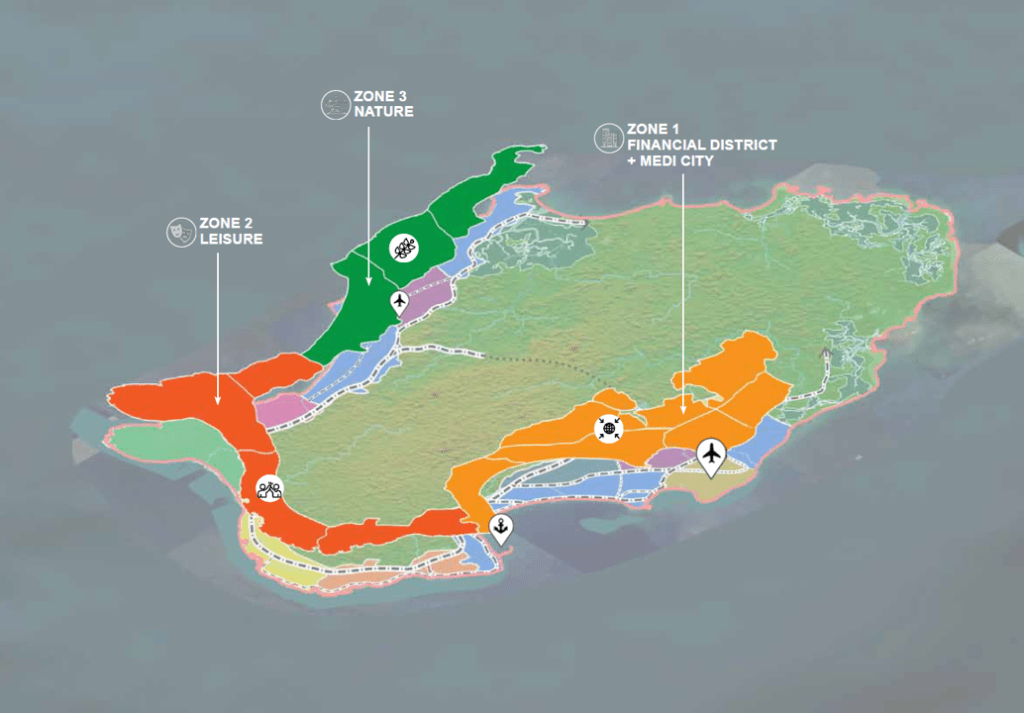
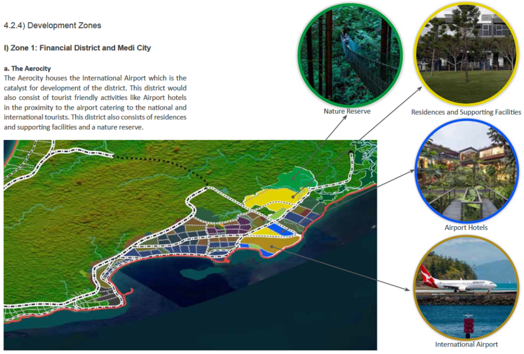


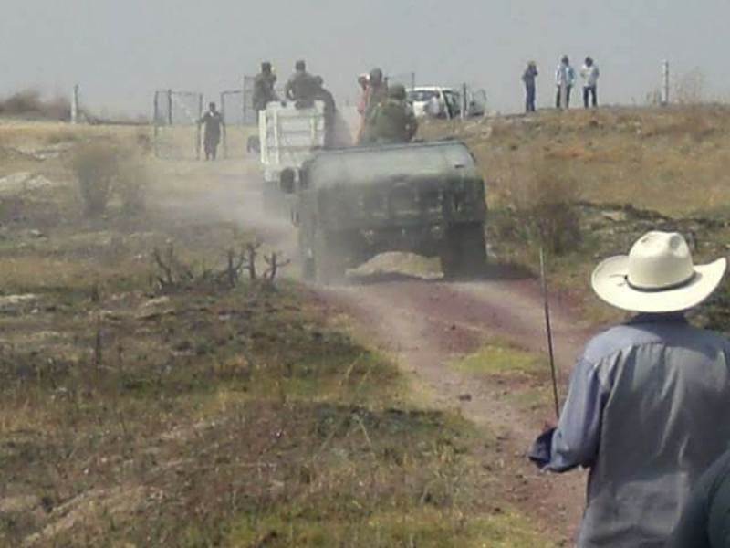 Mexican police forces invade ejidal lands in San Salvador Atenco near Mexico City where campesinos have resisted the expropriation of their lands for a controversial new airport.
  The ejido of Atenco, with the suburb of Ecatepec in the distance. Photos courtesy of high school students in solidarity with Atenco, except where otherwise indicated.”
 Cyclists protest plans for the airport. Image from
  Proposed Mexico City airport design by Fernando Romero and Norman Foster. Image from eVolo.
 A dirt road within the ejido.
 Field of cilantro, irrigated.
 Nopales grow on one of the hills from which Atenco residents protect their land.