3,500 families struggle for fair rehabilitation for displacement to make way for Navi Mumbai International Airport. Mangroves and other bird habitats will be lost and pre-construction blasting work has damaged houses and caused injuries.
Approximately 3,500 families residing in 10 villages face displacement from their homes and land for a new airport in Navi Mumbai, in the Kovar-Panvel area 40 kilometres to the east of Mumbai on India’s west coast. First proposed in 1997 and approved by the government in 2007, the response of affected people, resisting land acquisition and demanding improved rehabilitation assistance, is just one of many factors that stalled the Navi Mumbai International Airport project. The inevitability of environmental damage led to delays in being granted government clearances. Biodiverse wildlife habitats encompassed within the site will be destroyed: 121 hectares of forest, 162 hectares of mangroves and 404 hectares of mudflats. Environmental groups have long criticized the airport site selection, saying that the government refused to consider possible alternatives. Waterlogged and low-lying, the site will need to be raised from 2 metres to 5 metres above sea level, posing construction challenges.
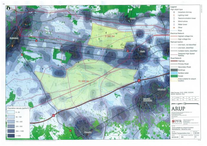
 A mega-airport is planned, handling 10 million passengers annually upon completion of the first phase, rising to 60 million passengers per year upon commencement of full commercial operations with two parallel runways, which is scheduled for 2030. If this traffic projection proves accurate Navi Mumbai will be India’s busiest airport. The airport core area, allocated for aeronautical activities, is 1,160 hectares of land. In addition to the core airport site, three areas have been earmarked for non-aeronautical activities (airport-linked commercial development such as hotels and retail), taking the total airport area to 2,268 hectares. Three plots of land have been allocated for rehabilitation and resettlement for the affected villagers.
Levelling the site and diverting rivers
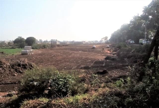
Villagers have not yet relocated to the resettlement areas. Yet, in October 2017, as they remain in their homes, massive earthworks preparing the site for construction of the airport began, a work programme that is expected to take between 18 and 24 months. The course of Ulwe river which runs north-south through the site is to be re-routed by 90° and the Ghadi river running alongside the northern boundary is also being re-channelled. Hills are being blasted away with explosives to make way for the airport runway, the soil and stones being utilized for filling in and levelling the site. The height of Ulwe hill, the largest hill on the site, is being reduced from 90 metres to 10 metres. Vast volumes of loose earth and stones will then have to be compacted down to make it stable enough to withstand airport operations.
Difficult terrain brings serious construction difficulties. The land is swampy and flood-prone, large areas are frequently waterlogged, especially during the monsoon season. “Even from a simple engineering point of view, building an airstrip on reclaimed land, mudflats and mangroves – it is going to be very unstable,” predicted Debi Goenka, executive trustee of the Conservation Action Trust. As of December 2017 most of the site was underwater. Critics of the airport project also point out the high level of state expenditure on pre-construction earthworks that are necessary to make the fragile coastal zone sufficiently resilient to withstand the new airport, an estimated ₹2,345 crore (US$370 million).
CIDCO (City and Industrial Development Corporation), a city planning agency formed by the Maharashtra state government, is responsible for implementing the airport project. GVK, an Indian conglomerate with interests in energy, resources, transport and other sectors, has been awarded the contract to build and operate the airport. By May 2018, CIDCO expects to hand the project over to GVK for completion of pre-construction groundwork on the airport site before the building phase begins. Predictions of project cost escalation have proved well founded. By 2017 CIDCO’s cost estimate for the project had more than tripled, escalating from US$753 million to US$2.5 billion.
As earthworks In November 2017 two thousand residents of the villages of Targhar, Pargaon, Ulwe, Kolhi, Kopar, Ganesh Puri, Chinchpada, Dungi and Manghar gathered to step up their demands for fair compensation and rehabilitation from CIDCO for vacating their land and homes to make way for the airport project. The villagers discussed many concerns including unnecessary land acquisition and united their struggles to form a new organization: Navi Mumbai International Airport Affected Peoples, which will take up their demands with CIDCO.
The villagers’ meeting followed a major protest by residents of six villages on 12th October, which brought pre-construction work on the airport site to a halt. An article on the mid-day.com news website stated that 5,000 people attended the protest. Only 10 per cent of the affected families had vacated their homes, over 3,200 families were still living on the site and they resolved to remain in their homes until the plots of land allocated for resettlement were developed. On 27th October it was announced that, following a meeting between CIDCO officials and affected residents, attended by 500 people and with a heavy police presence, work on the Navi Mumbai Airport site would resume under heavy police protection. CIDCO reported that four platoons of state reserve police had been made available.
Blasting damages houses, injures workers and villagers
The state is protecting the airport from people with legitimate grievances, but failing to protect people from construction of the airport. Blasting work caused residents to complain about tremors affecting their houses and has caused injuries. At the time of the October 2017 protest explosives were being set off three times per day, loosening the ground in order to cut and level Ulwe hill to make way for the airport runway. Taking place at a distance as little as 100 metres from people’s homes blasting sent stones flying distances of up to 200 metres, including into a nearby school. Vibrations from the blasting had caused cracks in the walls of houses in the village of Ulwe, making some people afraid that their houses might collapse.
On 6th January 2018 five engineers working in the site were injured, two of them severely, by supposedly ‘controlled’ blasting work that was underway 300 metres away from them. Explosions had triggered a landslide and the workers were hit by falling rocks. Villagers in Siddhart Nagar which is situated at the foot of Ulwe hill suffered injuries too; five women were bruised by stones coming through their roofs and a seven-year old boy who had been playing outside his house needed two stitches to his head. Affected residents, who had argued that blasting should not commence until they are rehabilitated, organized a protest march opposing blasting on the airport site and called for an atrocity case to be registered against CIDCO and GVK. Two days after the landslide, as GVK signed the concession agreement with CIDCO, the men of the village stalled work at the blasting site while the women made an unsuccessful attempt to meet with CIDCO officials at their offices. The father of the boy injured in the landslide, said “My wife and a few other women went to meet CIDCO officials, but they were not entertained. Why is it difficult to rehabilitate us when crores are being spent on the project?”
After the blasting injuries CIDCO officials ordered Siddhart Nagar residents to vacate their homes to get them out of the way while blasting work takes place, for two hours every day 1-2pm and 5-6pm. Villagers voiced strong objections to this disruption of their daily lives and being forced to stand in scorching sun. CIDCO’s lame excuse for undertaking the dangerous blasting work with people still in the vicinity is a claim that Siddhart Nagar villagers have not been rehabilitated because more than half of of the households were established after the 2013 cut-off date for eligibility. A representative of the villagers insists this is not the case and that they have documents proving their residency in the area for the past seven to eight years.
Residents’ long struggle for fair rehabilitation
Residents being displaced for Navi Mumbai Airport, facing loss of their homes, communities, land and livelihoods, have sustained a long-term struggle for fair rehabilitation. Back in 2010 a public hearing was boycotted by residents of all 18 affected villages standing to lose their land. Approval of the airport project appeared to be a foregone conclusion; journalist Nidhi Jamwal wrote that the hearing was ‘wrapped up in hour’, with the few journalists that attended having been told by their employers that negative stories would not be published. There was not much to report anyway as a recently completed Environmental Impact Assessment (EIA) and a study on the diversion and channeling of rivers were not made public. People from the affected villages stood outside the meeting waving black flags in protest, demanding due compensation.
Villagers being displaced for the airport, referred to as project affected persons (PAPs), are dissatisfied with the rehabilitation and resettlement areas and say that the offers of land and cash sums to build new houses in these designated areas are in sufficient to compensate for what they will lose. PAPS are being offered construction aid to build their new houses, but say that the amount, calculated in 2011, is low. Their request that construction aid be increased to reflect current costs seems particularly reasonable in the light of CIDCO’s repeated upward revision of airport construction costs.
At the time of the 12th October 2017 protest, which was precipitated by apprehensions over CIDCO’s looming 17th October deadline for villagers to vacate their homes, Nata Pratil, president of the committee of MLAs (Members of the Legislative Assembly) which is demanding justice for the 3,500 families facing displacement, said that the deal offered to villagers to give up their land was altered after they had agreed to it, the allocation of space for a new house being reduced. CIDCO claimed that the plots for displaced families were ready, but PAP representatives disputed this, saying that schools, utilities, streetlights, roads and a crematorium had yet to be developed. And PAPs said nothing had been done to make provision for replacing temples that will be lost to the airport. CIDCO had committed to allocation of plots of land suitable for relocation of ten old temples, along with compensation for rebuilding. In November 2017 some PAPs alleged that records proving their land ownership had been destroyed by CIDCO.
Loss of mangroves and the risk of bird-strikes
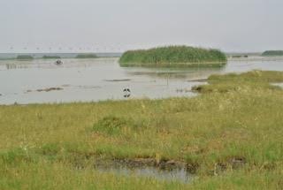
A significant regulatory hurdle to building Navi Mumbai airport, pertaining to the mangrove forest in the airport site, was removed in 2009. Coastal Regulation Zone notification, ensuring tight controls over construction, was amended in order to allow conversion of mangrove forest to an airport. Replacing mangroves with the impermeable concrete and tarmac of an airport will disrupt the water balance in the wider region. Mangroves are a natural buffer between land and sea, the interwoven roots preventing coastal erosion, absorbing rainfall and tidal surges. Excess water has to go somewhere and removal of mangroves for the airport could make the surrounding area more susceptible to flooding.
CIDCO’s suggestion of compensatory plantation to make up for loss of mangroves, about 200 kilometres distance from the airport site in Dahuna, met with criticism that these complex, locale-specific ecosystems, richly biodiverse and taking time to evolve, cannot be created instantly. CIDCO then suggested a mangrove sanctuary close to the airport site, commissioning a study of wetland bird habitats that was conducted by Bombay Natural History Society (BNHS). The study highlighted the conflict between airport operatiosn and birds. Dr. Deepak Apte, director of BNHS cautioned that “A mangrove park within the perimeter of aircraft takeoff and landing zones can be an extremely serious aviation hazard”. Mangroves are an attractive habitat for many bird species, so a mangrove sanctuary poses a risk of bird strikes, collisions with aircraft that can cause fatal accidents.
In 2015 the Ministry of Environment, Forest and Climate Change National Board for Wildlife withdrew the requirement for a mangrove sanctuary as part of the project. The developer will be required to make the area designated for the mangrove sanctuary unattractive to birds to reduce the risk of bird strikes. An environmentalist from Vanashakti, an NGO focused on forest, mangrove and wetland protection, questioned the sincerity of CIDCO’s promise of a mangrove sanctuary, wondering if it was known to be unfeasible due to the bird strike risk, and merely a ruse to help get clearance for the project.
Airport operations are likely to impinge upon birds habitats beyond the site – coastline, creeks, mangroves and inland wetlands. A survey conducted BNHS showed an estimated 266 bird species living within a 10 kilometre radius of the airport site, including the Karnala Bird Sanctuary. Aviation experts advised that a plan for a bird sanctuary to protect migratory flamingos, in the Panju-Funde wetlands, 20 kilometres from the airport site, would be under the take-off and landing flight paths and a bird strike disaster waiting to happen. Large birds such as flamingos pose the most significant bird strike risk. Debi Goenka criticized the airport authorities’ opposition to the Panju-Funde bird sanctuary: “In the name of development, we cannot simply kill all the beautiful birds and destroy their wetlands’ habitat. They could have easily shifted the proposed airport to some other place 10 years ago”
Interlinked megaprojects and car dependency
Construction of another megaproject, the Mumbai Trans-Harbour Link (MTHL), the longest bridge in India – is to be speeded up, for completion in time for it to be linked with Navi Mumbai Airport. Stretching across Mumbai Bay, six lanes wide and 22 kilometres in length, the new bridge will link the mainland with Sewri on the eastern edge of South Mumbai. Like the airport, the bridge is set to destroy birdlife habitats. First mooted in the 1970s it met with opposition because of the impact on Sewri mudflats, an area containing mangroves and providing an important feeding ground for the thousands of flamingos flocking there every winter. MTHL’s starting point in Sewri, extending along 5 kilometres of coastline, poses a threat to an estimated 20,000 – 30,000 flamingos and 38 hectares of formerly protected mangroves will be lost, along with 8.8 hectares of protected forest at the Navi-Mumbai end.
The shoreline sections of MTHL will impact on people as well as the environment. A 2016 assessment survey revealed that the homes of 229 families, 53 business premises and 10 commercial structures in Sewri will be demolished to make way for MTHL and an official outlined a plan to resettle then in Bhakti Park, Wadala, in southern Mumbai. Artisanal fisherfolk from nine villages whose livelihoods are impacted by MTHL will receive a one-time compensation fee. As of July 2017 over 3,000 compensation claims had been submitted and the Mumbai Metropolitan Development Authority (MMRDA) was about to begin sifting through the applications to identify ‘genuine claimants’. The cost of the MTHL bridge is comparable to Navi Mumbai International Airport at US$2.6 billion. Since 2005 when bids for the MTHL were first invited the cost has escalated significantly, by 350 per cent, due to delays, rising input costs, mandatory environmental and rehabilitation and design changes. Citizens will foot the bill directly through tolls and indirectly through various taxes.
A 5.8 kilometre coastal road connecting the MTHL bridge with Navi Mumbai International Airport is a megaproject in its own right; large stretches of the road will be elevated with a 1.76 kilometre section over mangroves to be built on stilts. The coastal road is just one of a proliferation of road infrastructure projects enabling traffic growth to support the new airport: new roads, widening of existing roads up to 8 and 10 lanes, loop roads and interchanges. Journalist Sanjay Banerjee envisages these ‘speed corridors’, described by CIDCO as enabling “smooth and seamless vehicular movements”, having an ‘octopus-like grip‘ across Mumbai. The airport-centric road building programme is designing in a high level of dependence on cars, it is based on a projection that 85% of air travellers will use private vehicles.


 and-a-half mile dual-carriageway extension of the A6-to-Manchester Airport “relief road”, which is already under construction (the red route in the map). It’s the latest in a series of new roads claimed to sort out the terrible congestion south of Manchester. The bypass would cost a huge £580 million! The result might not be what people imagine….

