Kenya: Trees felled in protected Imenti forest for airstrip, State Lodge and golf course

Plans for construction of an airstrip, State Lodge and golf course in the protected Imenti forest, an important elephant habitat and water catchment area, are opposed by many residents and conservation organisations. Felling of mature trees for airstrip construction continued despite conservatory orders to protect the forest and halt the projects.

Construction of an airstrip in the Kithoka area of the protected Imenti Forest began in June 2026
Construction of an airstrip in the Kithoka area of the protected Imenti Forest began in June 2026. Satellite imagery: 16/09/2025

Reports that allocation of 50 acres of Imenti forest, near Mount Kenya, for an airstrip, State Lodge (regional presidential residence and official venue for state functions and meetings) and golf course, was under consideration emerged in September 2025. Imenti forest, a protected public forest, is a habitat for elephants and many other species, an important water catchment for rivers and streams and is a source of income from agriculture and honey harvesting. Greenpeace Africa immediately opposed allocation of part of the forest ‘for luxury projects’, arguing that it would violate the Forest Conservation and Management Act, the Constitution and be a ‘betrayal of public trust’. The Green Belt Movement called for an immediate halt to the projects, saying the developments would be a misuse of a conservation area, stating, “How does an airstrip qualify as conservation? How does a golf course protect water catchments? How does a State Lodge restore degraded ecosystems? These projects are not necessary. They are luxuries. They are symbols of privilege. They have no place in a protected public forest.” Project proponents claimed that the developments would attract investors, create employment and enable hosting of high-level government events and international visitors but environmentalists warned that a reduction in forest cover would cause soil erosion, disrupt of water flows, reduce biodiversity and facilitate further forest encroachment and ecosystem fragmentation.

The Imenti Development Forum (IDF), a group of professionals involved in conservation and establishing ICT hubs in schools, issued a press statement opposing the plans, stating, “The Imenti forest is not simply trees. It is one of the region’s most significant repositories of biological diversity- a living library accumulated over millennia that, once destroyed, cannot be rebuilt in any human timescale.” Representatives of two political parties also opposed the projects: Party of National Unity leader Peter Munya and Jubilee Party deputy leader Dr. Fred Matlang’l who said another state lodge was unnecessary as the president already has access to high-speed aircraft and safe, modern hotels. North Imenti MP Rahim Dawood had initially favoured the projects but opposed locating a State Lodge in the forest taking up more than 20 acres of land and suggested locating a golf course elsewhere.

The Meru Environment and Land Court intervened to protect Imenti forest, issuing interim preservation orders pending hearing of a constitutional petition challenging the plans. On 11th June Justice Oguttu Mboya directed maintaining the forest in its current state until a court decision, barring activities that might impact on forest before issuance of further orders. The case was filed by Francis Awino who argued that the projects could cause irreversible damage. He also asked for preservation and disclosure of records connected to the proposed development such as environmental impacts assessments, maps, correspondence, license applications and approvals and planning documentation. The petition stated. “Public forests are held in trust for both present and future generations, and the State bears a constitutional obligation to conserve and protect them.” On that same day machinery entered the Kithoka section of the forest and, protected by security, began felling mature trees. Forestry Principal Secretary Gitonga Mugambi said construction of an airstrip would be completed within a week, by 18th June, with the first plane expected to land on that day. Kenya Forest Service (KFS) rangers had been deployed to guard all entrances to the site and local people entering the forest were frisked to check for smartphones, presumably to prevent recording of activities in the forest.

Conservation charity Rhino Ark issued a statement strongly opposing airstrip construction in the Upper Imenti Forest Reserve and calling on the National Environment Management Authority (NEMA) to suspend works pending assurance of compliance with environmental laws and criticised lack of the public participation, Environmental and Social Impact Assessment ESIA) and a NEMA license authorising the project. Surveys had found that, during the dry season, the Upper Imenti Forest has the highest concentration of elephants in the Mount Kenya area. The airstrip was being constructed within this elephant habitat, close to an elephant maternity area where pregnant mothers migrate to give birth. Greenpeace Africa pointed out that Imenti forest forms part of a wildlife corridor linking Mount Kenya to conservation areas in the north of the country, along which elephants migrate for food, water and mating. Greenpeace Africa said the National Land Commission should “Stop the bulldozers. Respect the court order. Let the elephants keep their dry season home. And prove, for once, that development in Kenya does not have to cost us the things we cannot get back.” The Mount Kenya Trust (MKT) made a statement condemning destruction of part of Imenti forest for an airstrip, maintaining that the project is in violation of Articles 42, 69 and 70 of the Constitution and the 2016 Forest Conservation and Management Act and could undermine Kenya’s commitments to increase tree cover, protect biodiversity and restore degraded landscapes. MKT stated, “We stand with those defending the protection of Imenti Forest and all protected areas for future generations.”

On 24th June Meru Environment and Land Court issued another interim conservatory order to halt construction of the airstrip, in response to a petition filed by five Meru residents. Petitioners said to the court, “The Respondents have failed to disclose Environmental Impact Assessment reports, feasibility studies, approvals, maps, acreage surveys and other statutory documents relating to the project. The proposed development threatens to cause irreversible degradation and destruction of forest resources.” The following day Meru Environment and Land Court certified an application, filed by Francis Awino, seeking to cite senior officials for contempt of court over allegations of continuing destruction of Imenti forest. In the Notice of Motion, Awino stated “Unless the contemnors are immediately summoned to answer for their actions, the authority and dignity of this Honourable Court shall be undermined…The continued and wilful acts of disobedience are causing and/or threaten to cause irreparable prejudice to the Petitioner’s constitutional rights, public interest and adversely desecrate designated forest.” A supporting affidavit alleged that, in defiance of court orders, prohibited activities continued including: granting commercial contractors, earth moving machinery and workers access to the Kithoka section of Imenti forest; felling mature trees, removing forest vegetation and clearing undergrowth to open up a corridor for a runway; bulldozing, grading and levelling works to prepare the forest floor for runway construction; and surveying forest areas for a proposed State Lodge and golf course. Geotagged satellite images, photographs and videos provided evidence of continued forest clearance. A petition filed by Meru Forest Conservation Forum and Pan-African Climate Justice Alliance resulted in a further conservatory order to halt developments in Imenti forest.

Belatedly, a public participation forum on the projects in Imenti forest was held, but it descended into chaos. The Meru Environment and Land Court had suspended the exercise as a change of venue with just 24 hours notice failed to meet the constitutional threshold for meaningful engagement. Defying a court order KFS proceeded with the forum and a group of stakeholders endorsed the airstrip, State Lodge and golf course projects. A lawyer attempting to serve a valid court order was denied access to the microphone and people presenting a petition opposing the projects that had been signed by more than 7,000 people were jeered at, threatened and removed by security officers. The Standard described the forum as ‘not public participation, but more of a staged exercise to endorse a decision that had already been made’. By 15th July 2026 the online petition, Hands Off Nkunga Forest! Stop the Destruction of Meru’s water catchment area, calling for an immediate halt to plans, surveys and budget allocation for the State Lodge, airstrip and golf course, had garnered 7,114 signatures.[17]

For more information including references for all source material, videos and photos see the case study on EJAtlas, the world’s largest, most comprehensive online database of social conflict around environmental issues – Airstrip, State Lodge and golf course in Imenti forest, Kenya
Vietnam: Development of dual-use (civilian and military) airport on Tho Chu Island

Conversion of 270 hectares of forest land has been approved for construction of Tho Chi Airport, classified by the Ministry of National Defence as an ‘urgent public investment project’ with an estimated total investment of VND28.8 trillion (USD1.1 billion).

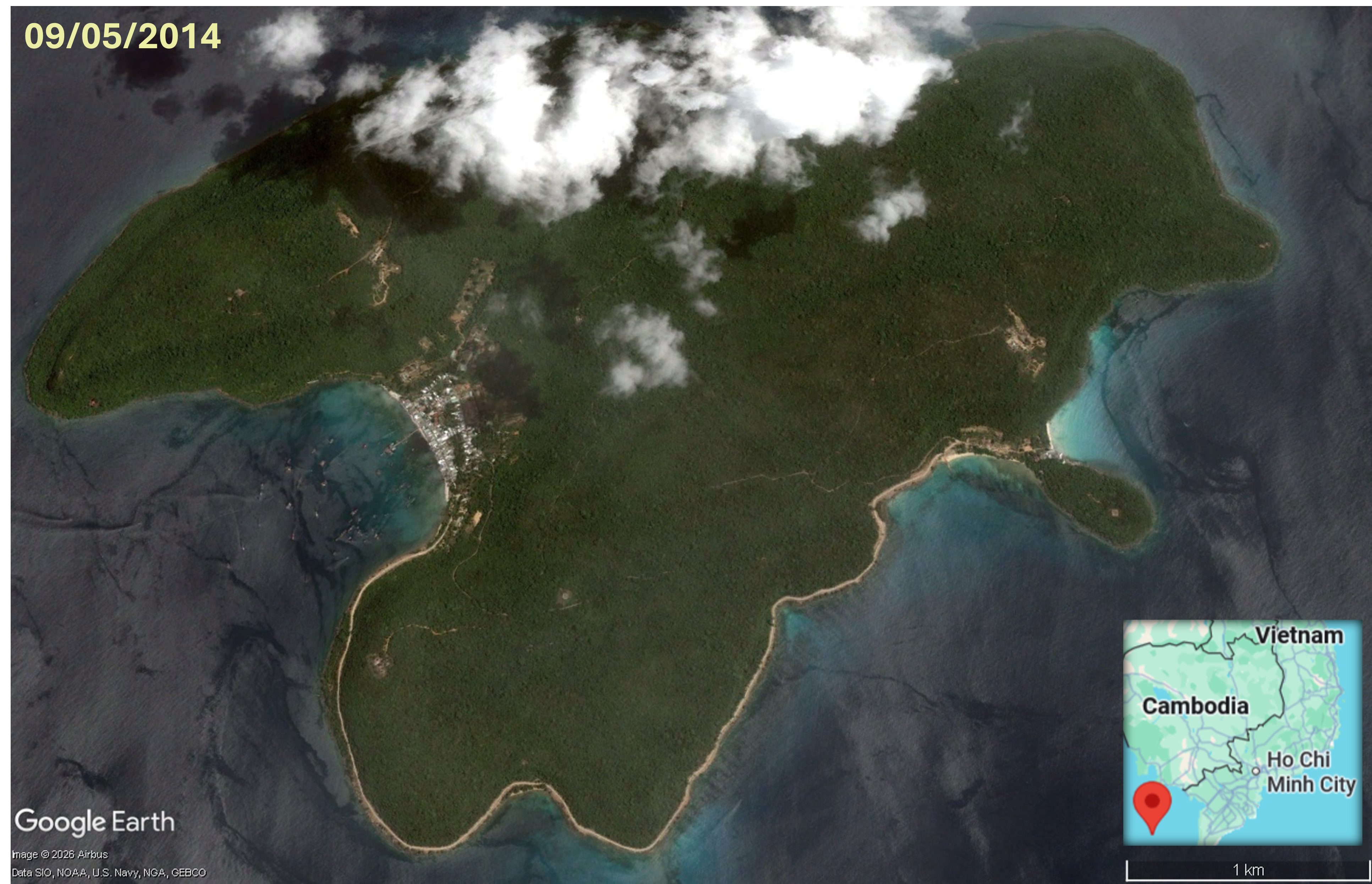
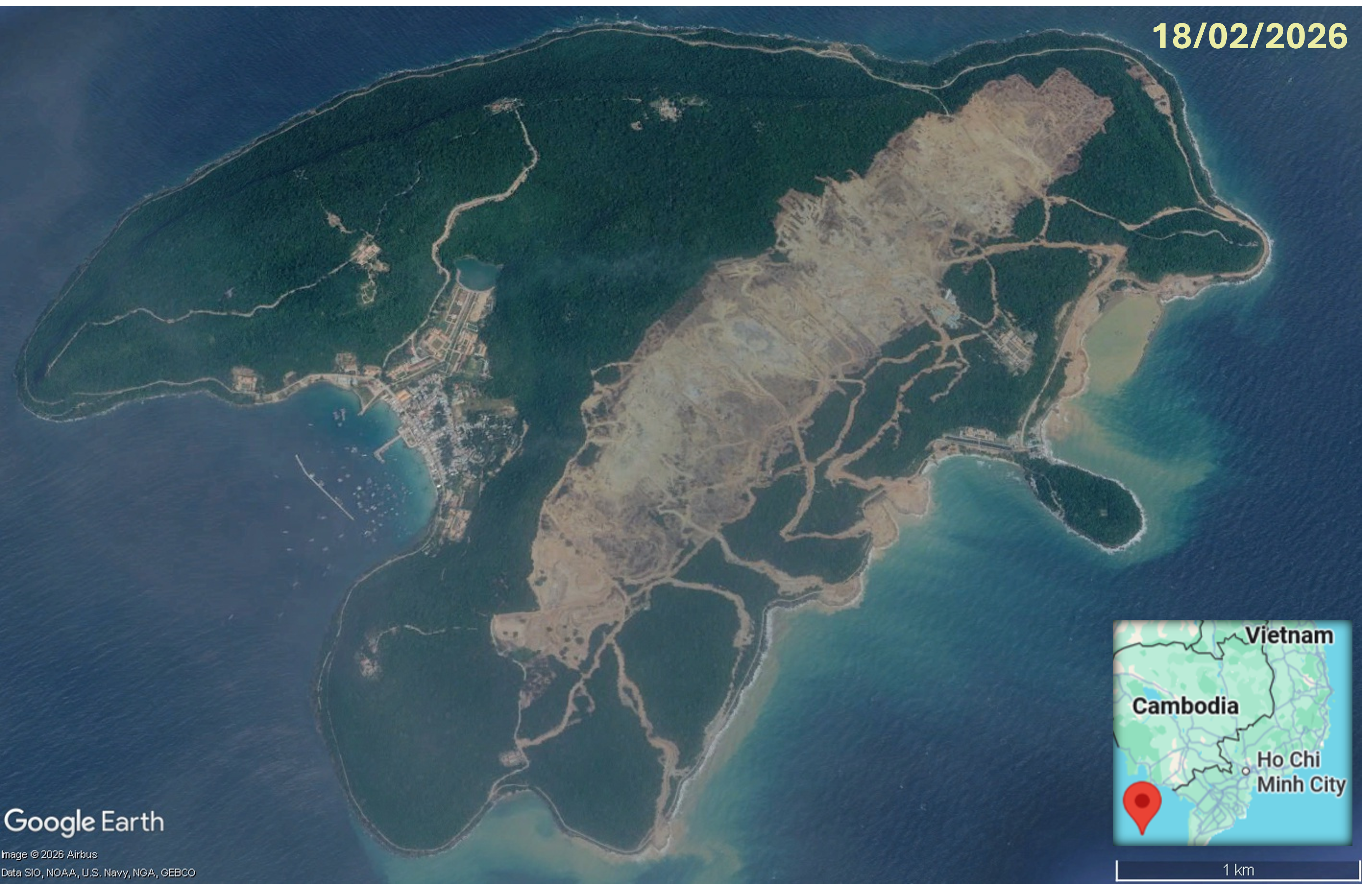
Tho Chu Island, aerial imagery 9th May 2014Tho Chu Island, aerial imagery 18th Feb 2026
Aerial imagery of Tho Chu Island.shows forest clearance, road network development and land reclamation that occurred between 9th May 2014 and 18th February 2026.

Geographically remote from the Vietnam mainland, and home to only 1,800 people, Tho Chu is located about 110km southwest of Phú Quốc Island in the Gulf of Thailand and is part of the An Giang province. Tho Chu is the largest and the administrative centre of eight islands comprising the Tho Chu Special Economic Zone and the archipelago is only accessible be sea. On a November 2025 visit, Party General Secretary and Secretary of the Central Military Commission, To Lam, called for transformation of the newly established zone into a ‘strong and sustainable maritime zone’, directing the Ministry of National Defence and other agencies to develop a master plan with feasibility studies for housing, upgrade of coastal road and other transport infrastructure, water and energy projects, and large seafood logistics and processing facilities. He spoke of the Tho Chu islands’ pristine ecosystems with clean seas, high-yielding fishing grounds, forest cover of 80-90%, sunny weather for seven months of the year and unique landscapes being ideally suited for ‘eco-tourism’. He also urged the Ministry of National Defence to consider construction of a dual-use (civilian and military) airport on Tho Chu Island, initially a 4C airport with capacity to handle narrow-bodied aircraft such as the Airbus A320 and A321 with potential future expansion to a 4E airport handling wide-bodied aircraft including the Airbus A350 and Boeing 787.

Plans for an airport on Tho Chu Island moved forward in December 2025 when Vietnam’s Ministry of Defence submitted a dossier for high-level review. The Tho Chu Airport master plan, for a dual-use airport, serving socio-economic development and transforming Tho Chu into a defence centre for the southwestern sea region, was added to the national airport network in May 2026. With an estimated total investment is VND28.8 trillion (USD1.1 billion) and land requirement of approximately 234 hectares the new airport is anticipated to reach capacity for approximately 20,000 passengers annually by 2030, rising to about 1 million passengers per year by 2050. The approved Tho Chu Airport plan is classified by the Ministry of National Defence as an ‘urgent public investment project’, exempt from investment policy approval and environmental impact assessment processes. The airport project aligns with the An Giang Province 2021-2030 development plan and on 21st May 2026 An Giang Province authorities approved conversion of 270 hectares of forest land for building Tho Chi Airport. The investor committed to pay for planting replacement forest. But newly planted forest is not a replacement for the biodiversity that builds up over time in long-established forest. And aerial imagery, in the timelapse graphic above, shows that, between April 2014 and February 2026, approximately 243 hectares of forest on Tho Chu Island was cleared. Grading works, levelling the site for construction, are underway, along with smaller scale forest clearance for coastal and access road development.

Nepal: Abandoned Sagarmatha Airport used for grazing cattle

Thousands of trees were felled for the Sagarmatha Airport project, but it has not been constructed and the abandoned site has turned into pasture.

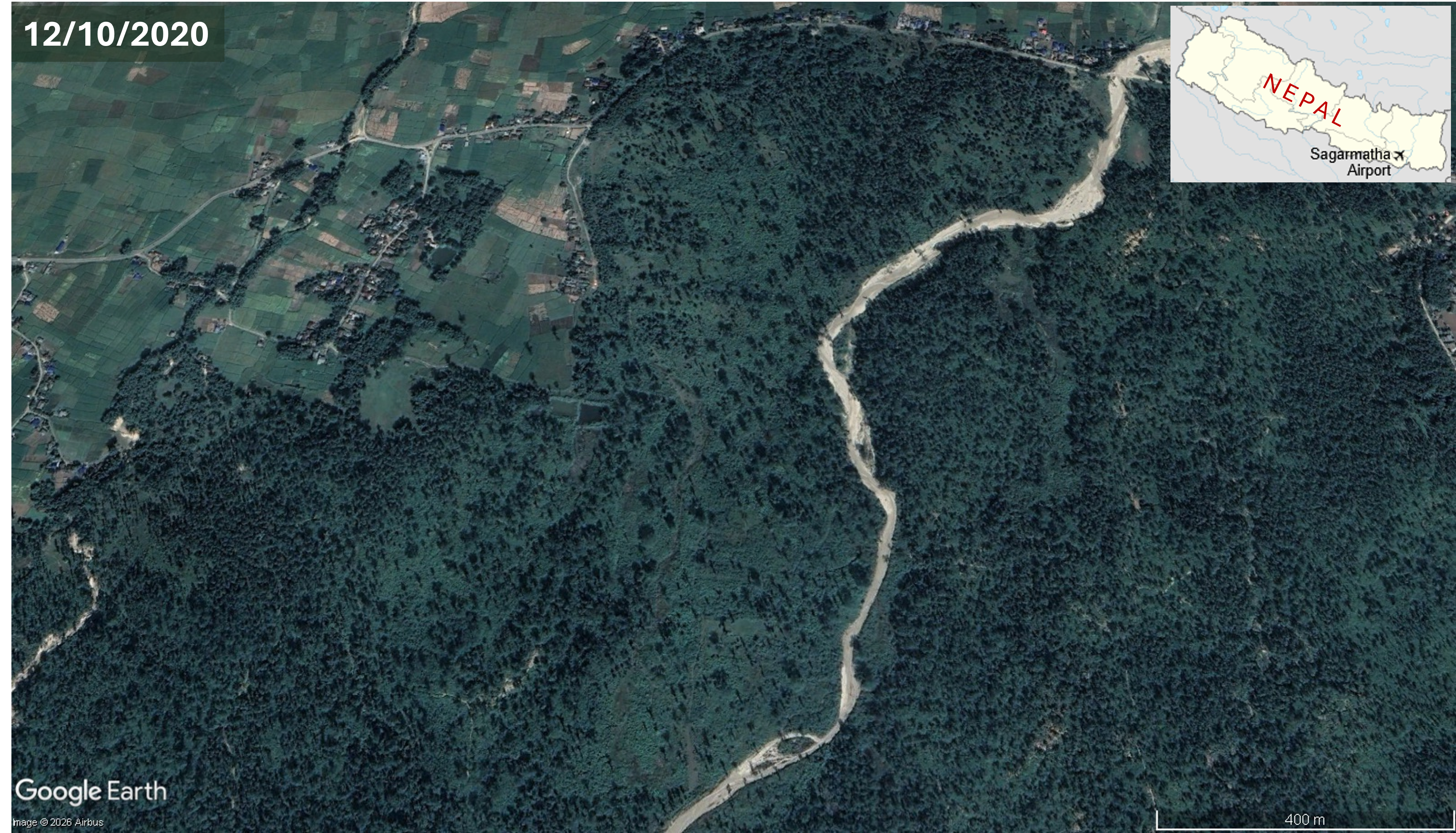
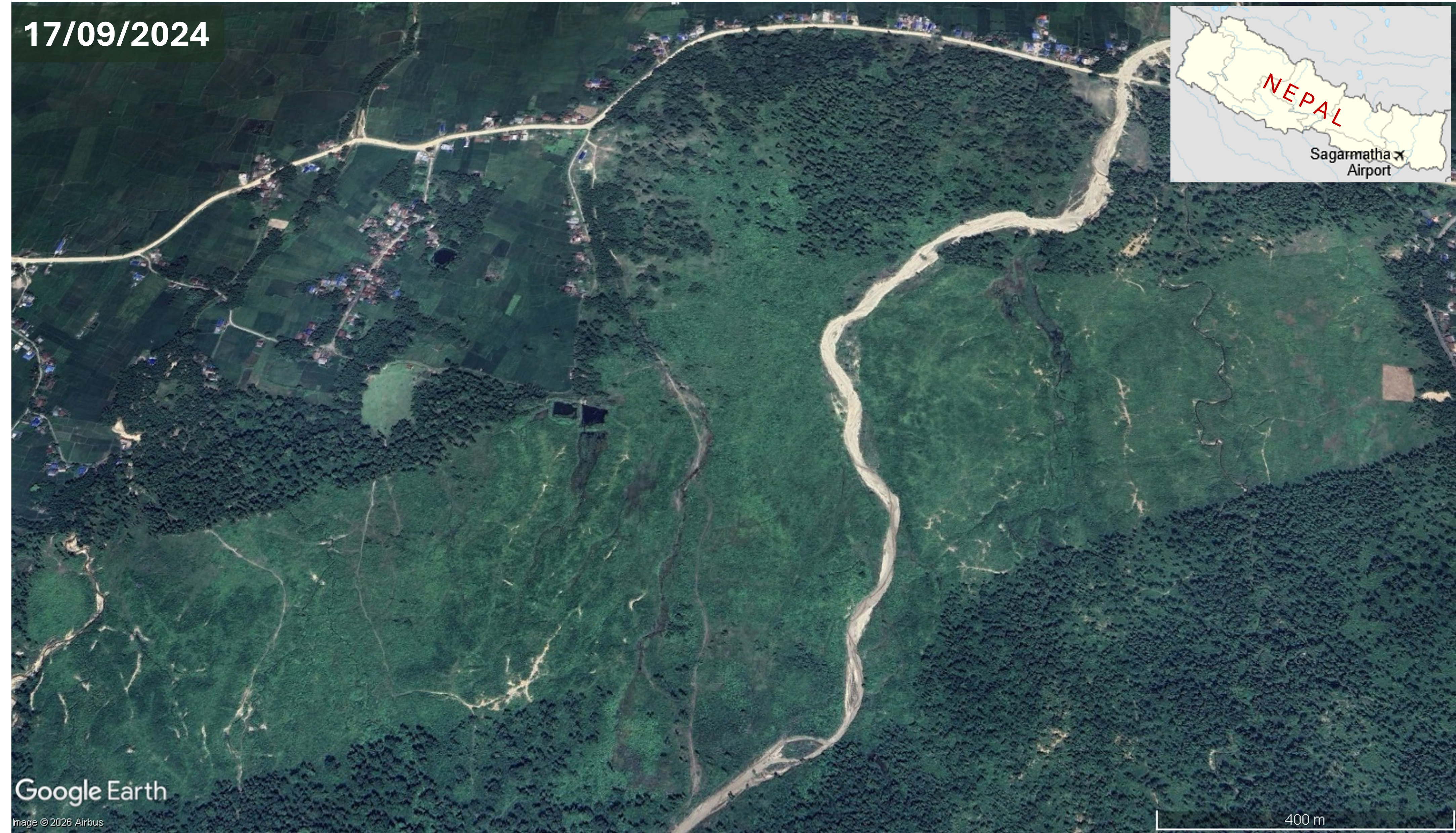
Sagarmatha Airport, 12th October 2020Sagarmatha Airport, 17th September 2024
Aerial imagery of the Sagarmatha Airport site shows deforestation in perparation for construction

The Sagarmatha Airport project, in Triyuga Municipality, Udayapur District of Koshi Province, Nepal, was first announced in 2013. According to the Environmental Impact Assessment (EIA) for the airport 35,514 trees covering 124 hectares of land would be cut down to make way for a 200 metre runway, terminal, taxiways, staff quarters and other infrastructure. In April 2018, responding to protests by local people against felling trees in the local community forest for the airport, the Triyuga Municipality began to consider building the airport on unused land along the banks of the Triyuga and Luhale rivers. A year later surveys of the proposed site were complete and the Ministry of Industry, Tourism, Forest and Environment (MoITFE) announced that construction of the airport was imminent. Site clearance for Sagarmatha Airport did entail large-scale deforestation; by November 2022 70 per cent of the trees in the 105.11 hectare area allocated for the project, at this juncture named Sagarmatha Domestic Airport, had been cut down by the company awarded the tender for construction of the airport. An agreement between the Department of Forestry and Soil Conservation, signed in February 2022, had allowed use of the forested land for the airport.

In January 2024, the Centre for Investigative Journalism-Nepal reported that the Civil Aviation Authority of Nepal (CAAN) had spent Rs 24.7 million (USD169,000) clearing forest for airport construction and approximately 13,687 trees from the community forest had been cut down and sold. Foundation stones marking the start of construction had been laid in three locations. Following a site visit in February 2024 Minister for Culture, Tourism and Civil Aviation, Sudan Kirati said the government would proceed with the airport and committed more funds, “A total of Rs 50 million has been allocated for the construction of the airport.”

In October 2025, Kathmandu Post reported that, after the forest was cleared, no construction works had taken place. The airport had not materialised and 105 hectares of forest cleared for the project was being used as grazing land for cattle. A Division Forest Office Official admitted that the timber was not fully accounted for or utilised properly and said, “Some wood was distributed to local users through community forest groups, but a large quantity was reportedly sold elsewhere”. Some locals alleged that forest officials and community forest group members had colluded in illegal sales of the highest-quality timber. A Triyuga local commented, “They destroyed the forest for an airport that never got built. What’s left now is a pastureland where people graze their cattle.” Environmentalists criticised the government for permitting forest clearance for an unviable airport project. Kushal Babu Basnet, Udayapur chair of the Federation of Community Forestry Users, said “This is a textbook case of how politically driven projects can cause irreversible environmental loss.” Responsibility for protection of the site, at risk of encroachment, was unclear with the Division Forest Office insisting that land ownership had been transferred to CAAN whereas the Land revenue Office denied any record of this.

Sagarmatha Airport is not the only abandoned airport in Nepal, the country has a history of building airports that languish unused. According to a report by CAAN, of Nepal’s 55 domestic airports only 32 were operational with just seven making a profit. A retired CAAN official includes Sagarmatha Airport in a long list of airports constructed at the behest of powerful politicians. Several airports in particularly remote areas had initially served as a ‘lifeline’ for isolated communities as there were no roads; many of these airports were built 1 – 3 hours driving distance from the national highway network. But when roads connecting these airports to national highways were constructed they were utilised by poor locals for whom the airports were not a priority. Weather is another factor affecting viability of new airports, some of which can only be used as seasonal facilities. Former CAAN director general Sanjiv Gautam explained that airport viability depends on the income of the local area, saying “many airports built in past decades have turned into grazing fields”.

Research by the Centre for Investigative Journalism-Nepal into Nepal’s abandoned airports, published in January 2024, mentions Sagarmatha Airport as one of several uncompleted and unused airports incurring significant public costs, ‘From East to West, there are more than 20 domestic airports in various stages of construction and abandonment’. Airports superseded by roads include Jiri Airport, the ‘gateway to Everest’, now used as pastureland following connection to the road network and the non-operational Tikapur Airport, in the far west of Nepal, through which locals have built a road.

Brazil: Forest around Fortaleza Airport felled for a logistics center

Sudden felling of forest next to Fortaleza Airport, in northeatern Brazil, to make way for a large logistics center met with protest from citizens and environmental groups, suspension of the project and proposals for an environmental protection zone around the airport.

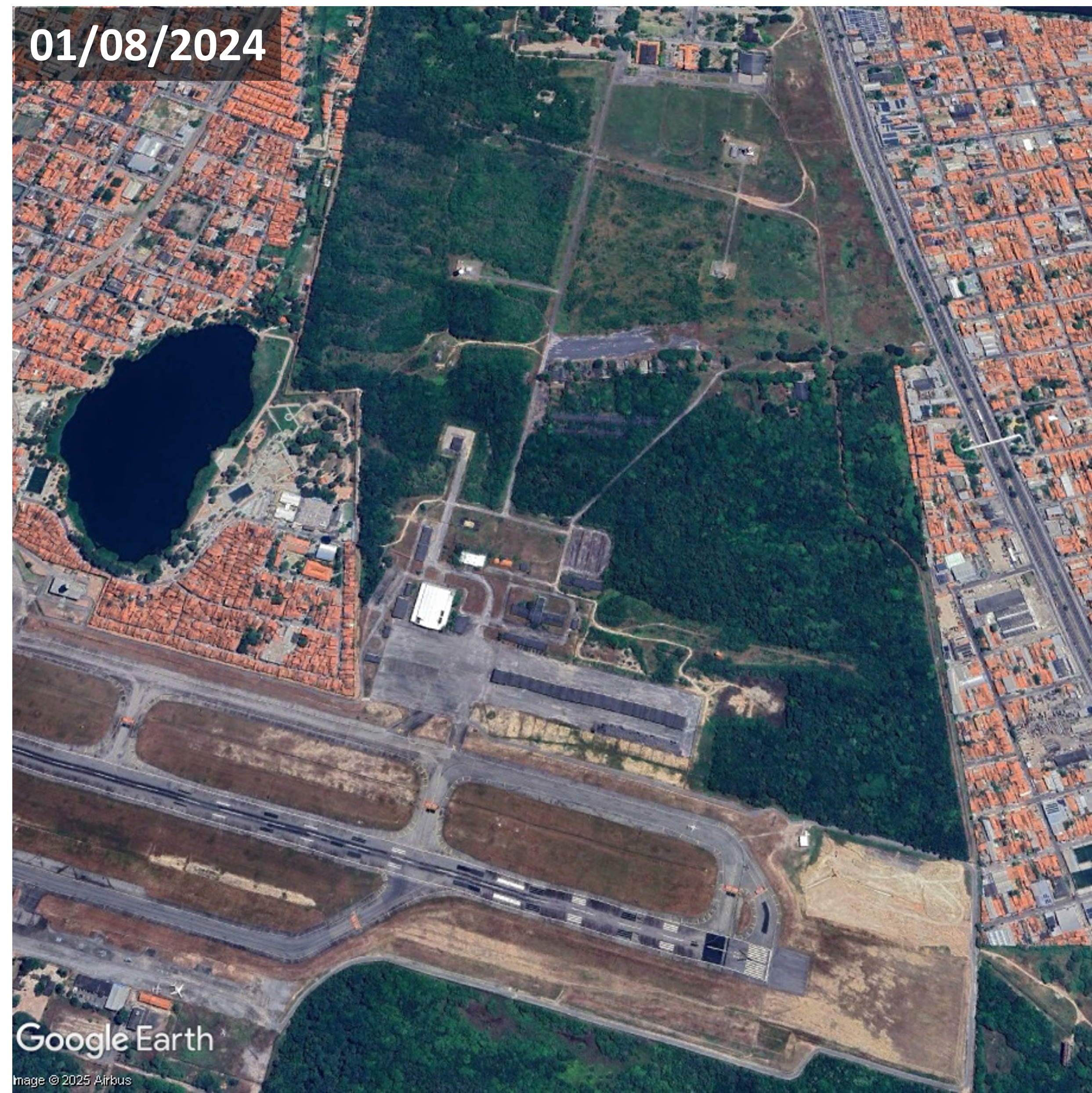
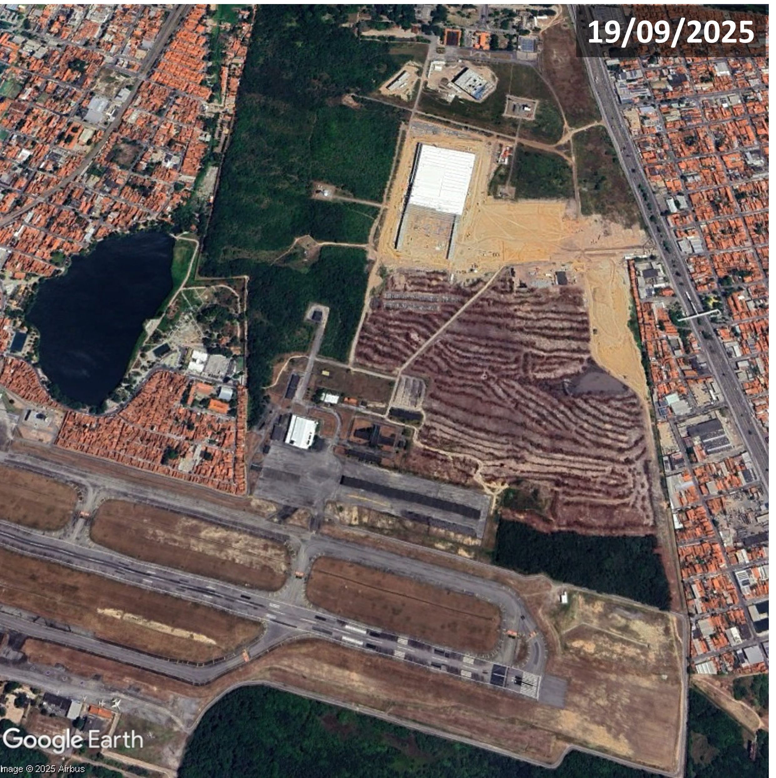
On 23rd September 2025 it was reported that 32 hectares of forest adjacent to Fortaleza Airport (also known as Pinto Martins International Airport), an area known as Airport Forest, had been felled to make way for a logistics center. The trees had been removed before the requisite documentation, submitted by project developer Aerotrópolis Empreendimentos and airport operator Fraport Brasil, had been evaluated by Instituto Brasileiro do Meio Ambiente e dos Recursos Naturais Renováveis (IBAMA), (Brazilian Institute of the Environment and Renewable Natural Resources) which requested evaluation of documentation in response to allegations that the licensing process had violated Atlantic Forest Law.

Fortaleza Airport, Aug 2024Fortaleza Airport, Sept 2025
Aerial imagery of Fortaleza Airport showing deforestation that was reported in September 2025

Deodato Ramalho, IBAMA superintendent, said the forest around Fortaleza Airport and Cocó state park are the only city’s only remains of the Atlantic Forest, extending along a long stretch of Brazil’s Atlantic coast and important for temperature regulation and flood prevention. Ecologist and Fortaleza city councillor Gabriel Aguiar said trees had been felled with chainsaws and reforesting the area would take many years. Daniel Pagliuca, an environmental lawyer and professor at Baturité Massif University Center, said forest clearance can be permitted for projects with public utility, but a logistics center would not directly benefit the local population. Animal rights experts raised concerns that many animals’ lives were in danger as forest clearance forced them into urban settlements. Images on social media showed animals climbing walls and poles around the airport.

Following analysis and site investigation Aerotrópolis Empreendimentos’ license and authorisation were suspended due to intervention in a Preservação Permanente (APP), (Permanent Preservation Area) and wildlife management inadequacies. Aguiar said the tree felling around the airport was the largest deforestation in a decade. Before and after satellite images showed total removal of trees and partial construction of a warehouse in the project area, immediately north of the western end of the runway. Residents and environmental and civil society organizations raised concerns over the logistics center project’s environmental impacts and demanded improved transparency in the licensing process.

During the 2nd October 2025 Encontro Nacional de Gerenciamento Costeiro (National Coastal Management Meeting) members of several social movements protested devastation of the Atlantic Forest around Fortaleza Airport. Environmental leaders from all over the country along with Ceará citizens called for revocation of Fraport’s license, accountability for the firms involved and reforestation of the deforested area. A banner read ‘Who killed the airport forest? 40 hectares of Atlantic forest devastated’ and signs stated that Atlantic Forest had been felled in the absence of a socio-environmental study or wildlife management. A total of 46-hectares had been cleared for construction of a logistics center, which has the potential to be one of the largest facilities of its kind in northeastern Brazil with seven warehouses, a truck service center, gas station and fuelling point. Residents around the impacted area were experiencing higher temperatures; preliminary research comparing surface temperatures from the same time period the previous year indicated an increase of at least 6 per cent, thought to be related to the deforestation.

After an inspection uncovered irregularities including removal of vegetation exceeding authorized limits SEMACE issued Aerotrópolis Empreendimentos with a USD37,315 fine and suspended land use permits in the affected area. At a conference considering amendments to the draft Fortaleza Master Plan a 200-hectare Zona de Preservação Ambiental (ZPA), (Environmental Protection Zone) around Fortaleza Airport, encompassing the deforested land, was approved. Professor Renato Pequero said the designation increased the possibility that the deforested area might be restored. Gabriel Aguiar welcomed the victory and called for the city’s biggest ever mobilization to ensure approval of the ZPA proposal.

Fortaleza Airport City
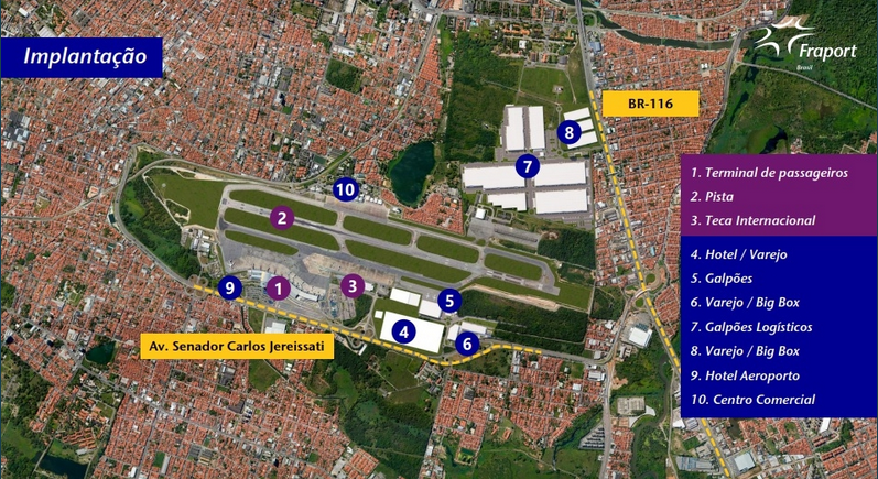
Fortaleza Airport City plan graphic – Fraport announced expansion on land adjacent to Fortaleza Airport in 2022.
Source: Fraport Brasil

The logistics center next to Fortaleze Airport is part of a larger airport city project. In July 2022, Fraport Brasil announced expansion onto land adjacent to the airport for Fortaleza Airport City, a development of over 80 hectares. Along with a logistics center planned facilities included two hotels with independent access to the airport, shopping mall and supermarket. A graphic published with the announcement shows logistics warehouses, big box retail, a hotel and commercial center.

For more information including references for all source material, photos and videos see the case study on EJAtlas, the world’s largest, most comprehensive online database of social conflict around environmental issues – Deforestation around Fortaleza Airport, Brazil

An oral history of settlements impacted by Istanbul’s Third Airport

The local impacts of Istanbul’s third airport are explored in Whose Land? Whose Villages? The Vanishing Settlements of Istanbul’s Northern Forests by Cihan Uzunçarşılı Baysal, published by Housing and Land Rights Network. Oral history research records the testimonies of residents of eight villages in Istanbul’s Northern Forests which have been affecteded by the megaproject: Ağaçlı, Yeniköy, Karaburun, Durusu, Balaban, Tayakadın, Baklalı and Dursunköy. Construction works including quarries, excavation, cement plants, sand mining and land reclamation ‘made everyday life unbearable’. Part of the the vast 7,650 hectare airport site was forest land seized by the state, supposedly for public purpose. About 13 million trees were felled. Fertile agricultural land, meadows, lakes, wetlands and a stretch of coastline were also destroyed to make way for the airport. Impacts on agriculture and livestock breeding, in particular water buffalo, have been devastating. One resident estimated that 500-600 water buffalos used to graze around Kulakçayır lake, its landfilled remains now lying underneath the runways. This report, with some of its interviews interrupted by the incessant noise of planes flying overhead, helps keep alive memories at risk of being buried along with the ecosystems.

Report - Whose Land? Whose Villages?

Construction of an ‘Eco-Tourism Airport’ on Koh Rong island

Earthworks for construction of an airport on Koh Rong island, 25 km from the city of Sihanoukville on Cambodia’s south-west coast, began in January 2024. Satellite imagery shows the airport site, located in a flat area in the centre of the island. The new airport with a 2.650 metre runway will have capacity to handle 138,000 passengers annually upon completion of the first phase and the MoU signed in January 2023 formalised a budget of $300 million. The necessity and viability of Koh Rong International Eco-Tourism Airport seems questionable with two major international airports nearby. Newly constructed Dara Sakor Airport, with capacity for 10 million passengers per annum and scheduled to begin operations in November 2024, is only 21km away. Sihanouk Airport is 45 km away. Also, Koh Rong is already well served by boat; the ferry journey from Sihanoukville only takes about 45 minutes.

Satellite imagery of Koh Rong dated 1st November 2023, showing location of the four coastal villages, Royal Sands resort, long beach, major roads and Koh Rong International Eco-Tourism Airport construction site.

The new airport will be named ‘Koh Rong International Eco-Tourism Airport’. While an airport enables people to visit and explore protected beaches, forests and native wildlife habitats, it does the very opposite of protecting ecosystems, concreting over a vast area for runways, terminals and access roads. Then there is the issue of climate disrupting greenhouse gas emissions from flights, with aviation being energy intensive and dependent upon fossil fuels. And tourism development on Koh Rong has damaged ecosystems and the people depending on them. In 2008, Royal Group, one of the largest investment and development companies in Cambodia, was granted a 99-year land concession to develop the 78 square kilometre island. Realisation of the masterplan – featuring resorts, casinos, marinas, golf courses, two fishing villages and an airport – was delayed but commenced in 2015 with clearance of sites along the southwestern coast including forests along with construction of a road. On 3rd July 2015 Koh Touch villagers held a sit-in protest, blocking construction crews, excavators and a bulldozer, in response to construction of a road which they said would cut through their village and affect their homes. Later that month opposition to development of Koh Rong became more vocal in response to construction equipment and workers appearing on the island. Hundreds of residents began to speak out on social media. As well as cutting trees cliffs and rocky outcrops had been flattened for development, including a new pier on Long Beach, on the southeast of the island.

In August 2015 a number of Koh Kong residents called on officials to review what they called “abusive activities” by Royal Group. Construction had accelerated in recent weeks and workers and machinery had been photographed clearing large areas of forest. Residents accused Royal Group of destroying farmland and crops, including cashew, jackfruit, coconut and mango trees. A village leader said destruction could impact the livelihoods of over 100 families, who had lived on the island since 1995. Villagers said the destruction of their livelihoods was illegal and authorities should monitor the situation. Human rights and environmental campaigners supported residents’ calls for improved oversight and local groups were preparing petitions and other documents to file with provincial and national authorities. Protest groups had been formed in response to a breakdown in communications between residents and Royal Group. One villager said, “They come in and do their work, take whatever they want, but there is no communication”. 

Controversy over land titles for Koh Rong villagers was reported in 2017. Some residents who had lived on the island since before 2008 had land titles, although it was uncertain whether these titles would be upheld amid disputes. Those arriving after 2008 did not have land titles. By 2018 over 1,000 land plots, belonging to 500 families, had been recognised by the government, but in April 2018, during the inauguration of the luxurious, five-star Royal Sands Koh Rong resort, about 50 people who had not yet received land titles attempted to join the event but were prohibited from doing so. Prime Minister Hun Sen ordered the Ministry of Land Management to bring an end to the Koh Rong land dispute. In June 2020 53 families protested land clearance; a 35-hectare site they believed rightfully belonged to them was being bulldozed. A Preah Sihanouk Provincial Administration spokesperson called on the protesting families to cooperate with authorities by providing relevant documents and warned them that if they caused chaos legal action would be taken against them. A member of one of the protesting families claimed they had lived in the area since 1992 and said: ”We won’t go anywhere. I will gather to protest at this site. We dare not enter the bulldozing site. I want Prime Minister Hun Sen to see and tackle this issue for us. We all have ownership documents.”

In June 2024 Mongabay reported that a new map of Royal Group’s plans for Koh Rong showed golf course zones, commercial zones, accommodation zones, casinos zones and an international airport. The latest plans did not appear to impact fishing villages but included clearing some of the Koh Rong’s protected forests to make way for golf courses. In total, project plans entail clearing more than 3,100 hectares of the island’s forests. A photo showed bulldozers and trucks working on the airport site. Sixteen years after the land was leased to Royal Group there was still no publicly available social or environmental impact assessment and islanders’ future was uncertain. Some Koh Rong residents hoped to sell their land to Royal Group while others feared that it would be taken from them.

For more information about the airport and tourism projects on Koh Rong island, including references for all source material, see the case study on EJAtlas, the world’s largest, most comprehensive online database of social conflict around environmental issues: Koh Rong island tourism development, Cambodia.

Aerocity catalyst for Little Andaman plan

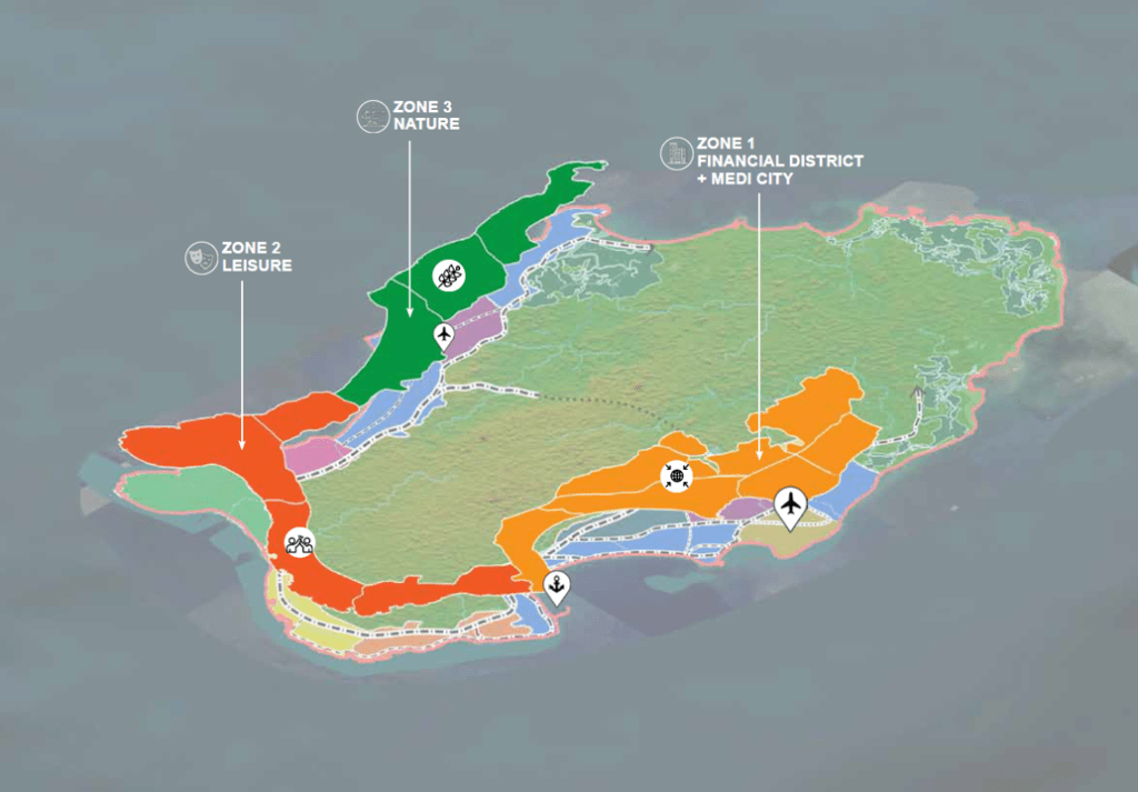
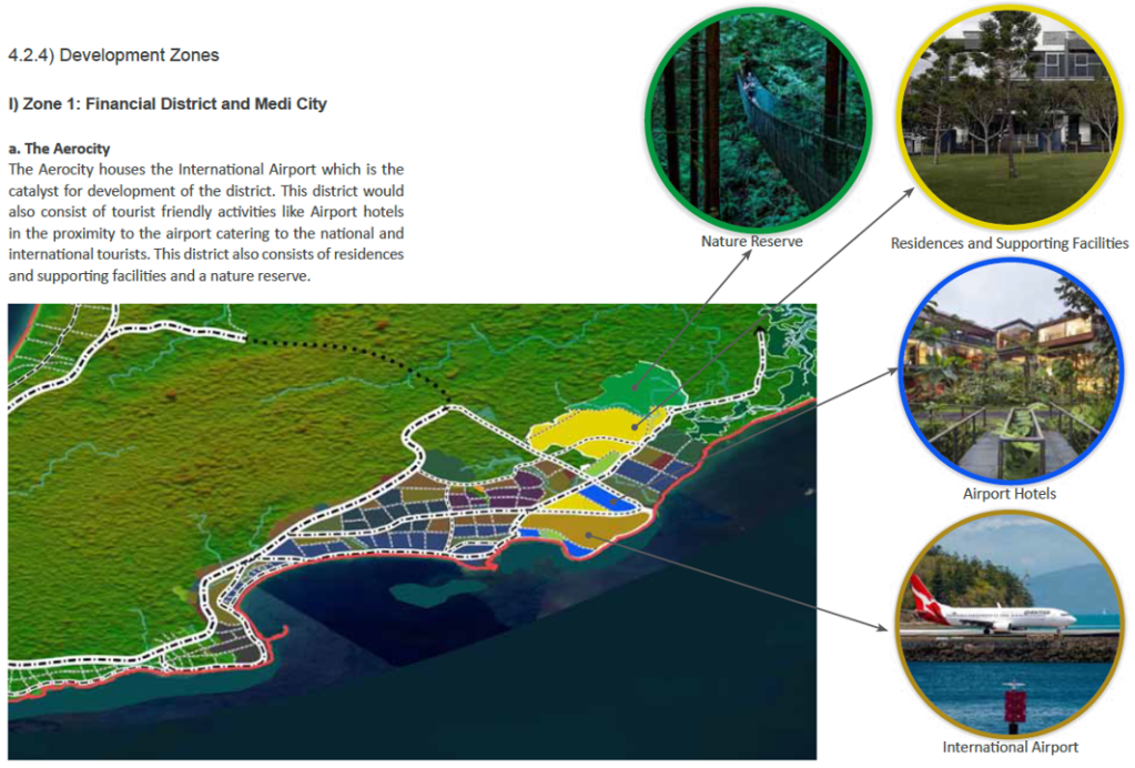
Airport development features heavily in a plan for tourism-oriented megaprojects on Little Andaman Island, the southernmost island of the Andaman archipelago. Graphics below, from the 58-page ‘Sustainable Development of Little Andaman Island – Vision Document’, show: Zone 1, on the eastern coast, featuring an Aerocity, housing an international airport, envisaged as ‘the catalyst for development of the district’; Zone 2, on the southern coast, including a Leisure Zone and Tourism SEZ (special economic zone) with casinos, theme park and beach hotels; Zone 3, on the western coast, a Nature Zone containing super-luxury resorts and hotels, with an airstrip for private charter flights.

  • Little Andaman plan
  • Little Andaman plan indicating 3 zones
  • Map of Zone 1 of Little Andaman plan. The Aerocity is the catalyst for developmen

Sudden news of the plan, in January 2021, alarmed conservationists. The ‘Vision Document’, thought to have been finalised a few months previously but not in the public domain, is included in ‘A MONUMENTAL FOLLY: NITI Aayog’s Development Plans for Great Nicobar Island (An evolving archive of reports, information and documents)’, compiled by Panjaj Sekhsaria and published by Kalvpavriksh Environmental Action Group. The total project area is nearly 240 sq km, 35% of the island; the three zones would take up 107 kilometres of the island’s coastline. Development of this scale would have major impacts on indigenous people and the island’s unique biodiversity and forests. Little Andaman is home to the Onge tribe, living on the island for more than 50,000 years, the population dwindling since 1900. Now numbering an estimated 125 people the Onge tribe is categorised as one of India’s Particularly Vulnerable Tribal Groups (PVTG). According to the plan the Onge Tribal Reserve would be reduced by 31%; the Vision Document states that steps would be taken to relocate and protect Onge people but no detail is given. An anthropologist pointed out that bringing areas where Onge, with nomadic origins, do not live into the proposed development would still impact them, saying “the Onges have a close attachment with their territory be it inhabited or not”.

The Divisional Forest Officer of Little Andaman raised concerns that the major diversion of forest land for the project would cause irreversible damage to the island’s forests, entailing the loss of more than 2 million trees. An official source said there are over 2.4 million trees in the “vast tract of forests” in the areas where development is proposed. Removal of trees would cause topsoil erosion and reduce rainfall, impacting on the small area of the island with cultivable soil. Uprooting more than 2 million trees for the Little Andaman plan would also result in carbon emissions and carbon stock losses. Carbon pools were calculated for the four forest types in the development areas: nearly 136 sq km of Evergreen/Semi Evergreen and smaller areas of Deciduous, Swamp/Mangrove and Plantation forests. A study estimated that implementation of the ‘Sustainable Development of Little Andaman – Vision Document’ would result in carbon stock loss of 2,996.286 tonnes from five categories of carbon pools: 55% from woody debris and soil organic matter, 32% from above ground living biomass, 9% from below ground biomass, 3% from dead mass of litter and 1% from dead wood.

Nesting sites of Giant Leatherback Turtles, the world’s largest turtles growing over 6 feet in length, with many populations in precipitous decline, are threatened by the Little Andaman plan. South Bay and West Bay on Little Andaman are both high-intensity nesting sites and among the most important in the entire island chain. Along with other nesting beaches on the islands, the two sites are specifically mentioned as ‘Important Marine Turtles Habitats in India’ in the National Marine Turtle Action Plan. There are fears that implementation of the ‘vision’ would push the leatherback turtles to the brink of extinction. A 2019 report on a long-term monitoring programme at Little Andaman island identified previously unknown migratory routes of Great Leatherback Turtle nesting in the region, highlighting their dependence upon foraging and nesting sites that are thousands of kilometres apart. Nine tracked turtles traversed much of the Indian Ocean, as far southeast as Western Australia and towards the eastern coast of Africa. The turtle travelling the furthest, close to the western coast of Mozambique, covered 13,237km in 266 days; it was also the fastest, travelling an average of 49.8km per day.

More information about the Little Andaman plan has been published on EJatlas, the world’s largest, most comprehensive online database of social conflict around environmental issues: Little Andaman Development Plan

Video – Aerotropolis: Evictions, Ecocide and Loss of Farmland, part 2

The second part of a two-part video, Aerotropolis: Evictions, Ecocide and Loss of Farmland, highlights damaging impacts of aerotropolis (airport city) projects on people and the environment. Evictions can be large scale and there are many instances of human rights violations. Allocation of large greenfield sites places farmland, forests, wetlands and coastal ecosystems at risk.

The video looks at 14 aerotropolis-type projects: Central Transport Port-CPK (Poland), Manchester Airport City (UK), Airport City Gatwick/Horley Business Park (UK), New Mexico City Airport (NAICM), (Mexico), Santa Lucia Airport (Mexico), Northwest Florida Beaches Airport (US), Vernamfield Aerotropolis (Jamaica), Hamilton Aerotropolis (Canada), Pickering Airport/Toronto East Aerotropolis (Canada), Mattala Airport (Sri Lanka), Nijgadh Airport (Nepal), Istanbul Airport (Turkey), Bulacan Aerotropolis (the Philippines) and Sanya Hongtangwan Airport (China). For further information see the comprehensive Reference list of all source material, including photos and other images. Part 1 of the video can be viewed here.

Nijgadh aerotropolis – 2.4 million trees could be felled, and 7,380 people displaced

An 80 square kilometre aerotropolis is planned in Nijgadh, Nepal. The projects entails displacement of 7,380 people and felling of 2.4 million trees.

A major aerotropolis is planned in Nijgadh, in the Bara District in southeastern Nepal, 175 kilometers south of Kathmandu. If the megaproject proceeds as planned as many as 2.4 million trees will be felled, and 7,380 people living in the Tangiya Basti settlement within the site will be displaced. The government has repeatedly stated that Nijgadh Airport with a 80 square kilometer site, will be the largest, by area, in South Asia. An airport city adjoining the airport is planned. The map below shows the proposed Nijgadh Airport boundary as reported in the Nepal Gazette on 5th June 2015. The site is between two braided rivers, Pashah to the west and Bakiya to the east. The northern boundary is the Mahendra Highway between the two rivers. Most of the site, about 90 per cent, is densely forested land, predominantly consisting of Shorea robusta trees, which are also known as Sal or Sakhua. The settlement in the middle of the airport site, where about 7,380 residents living in 1,476 households face eviction, is called Tangiya Basti.

Nepal - proposed boundary of Nijgadh Airport, an 80 square kilometre aerotropolis
Nijgadh Airport site boundary , as described in Nepal Gazette, 5th June 2015

A series of government announcements underlined determination to pursue the project. In June 2014 the government emphasized determination to attract investors, reportedly ‘preparing to complete the pre-construction works to spare the investors all the hassles whether the government, private sector or foreign investors invest on the project’ as preparations were being made to fence off the land. January 2016 saw another high level push to commence construction of Nijgadh airport. The Ministry of Culture, Tourism and Civil Aviation (MoCTCA) was instructed to begin land acquisition, site clearance and resettlement of affected people and the Ministry of Soil Conservation was directed to fell trees and clear the site for the construction of primary and access roads to the airport site within two months.

It appears that a confirmed investor in the airport has proved elusive. Public funds will be used to develop the project. On 24th May 2016 the government allocated US$46.4 million for the construction of Nijgadh Airport, for land acquisition, resettlement of displaced people, environmental impact assessment and preparation of a detailed project report. The Tourism Minister said the project would be developed in phases, beginning with a single runway facility with capacity for 20 million passengers annually, with the accompanying airport city to be constructed at a later stage. In January 2017 the government assigned preparatory work on Nijgadh Airport to the Nepal Army, tasking it with building a perimeter road and an access road to the area earmarked for the runway, and clearing trees to make way for construction.

600,000 trees could be felled to fund Nijgadh Airport construction

By May 2017 forest earmarked for Nijgadh Airport remained unfelled, but vast numbers of trees could be transformed from an obstacle to airport construction into a source of funding for it. A news article entitled ‘Money grows on trees for Nijgadh airport project‘ reported a statement by officials that a vast swathe of the forest, about 600,000 trees, will be felled for the airport. The market value of the lumber was estimated at nearly US$581 million, which would be sufficient to pay for half of the US$1.172 billion construction costs for the first phase of the airport. The Forest Ministry permitted the Tourism Ministry to conduct an EIA (environmental impact assessment) on the condition that 25 trees are planted for every tree that is cut down.

Tourism Ministry officials pointed out that tree planting on this scale this would be difficult to implement, as felling 600,000 trees would require the planting of more than 15 million saplings. The suggestion that 15 million trees could be planted is more than merely ‘difficult’; it is completely unfeasible. Any such mega tree plantation could not replace the rich biodiversity of an long-established forest ecosystem and an enormous land area would be required, inevitably entailing the wholesale obliteration of an existing ecosystem in order to plant such a huge number of trees.

2.4 million trees could be felled for 80 square kilometre aerotropolis

Subsequent announcements in July and August 2017 threaten the felling of even more trees for Nijgadh Airport, over 2.4 million, to make way for the full 80 square kilometer aerotropolis. The first phase of the airport will spread over between 1,000 and 2,000 hectares, and CAAN has assigned the Nepal Army to clear trees at the airport construction site and to build access and perimeter roads. The government has allocated US$14.6 million for the project this fiscal year with CAAN setting aside an additional US$29.2 million to pay for initial works, if required.

A short video of the forest at risk of being destroyed for Nijgadh airport was posted on Twitter, by Milan Dhungana, who commented: “It’s very hard to believe that this beautiful dense forest is soon to be vanished to give way to a new airport.”

Photos of the forest that is at risk of being felled were also posted on Twitter:

7,380 people face displacement

Residents of Tangiya Basti, 7,380 people living in the settlement in the midst of the forest land earmarked for Nijgadh aerotropolis, face displacement. In June 2014 MoCTCA was attempting to settle disputes over compensation for land acquisition and people’s demands for resettlement arrangements. By March 2016 the task of collecting land details had been completed, with land valuation about to commence, along with issuing public notices for land acquisition. Land had been categorized as under individual ownership, public land and ‘unidentified ownership’, the majority belonging in the latter category. A video shows the Civil Aviation Authority of Nepal (CAAN) sign erected at the Nijgadh Airport site.

A 35-day notice was published for landowners to apply for compensation in March 2017. The amount of compensation for land acquired for the airport had been confirmed and the notice required landowners to harvest their crops within a month, prohibiting them from cutting any trees or plants. But compensation is only available to a minority of residents who have recognized land ownership. A September 2016 project report by Tourism Secretary Prem Kumar Rai stated that 110 households were eligible for compensation, with between 80 and 85 of these households agreeing to the compensation and the remainder reluctant to accept the government’s offer. The majority of residents facing eviction, about 1,400 households, have been categorized as ‘squatters’. Chief of the airport project, Hari Adhikari, said that nothing had been done to resettle the ‘squatters’ living on the construction site. In July 2017 the Himalayan News Service reported that the government’s preparations to acquire land for Nijgadh Airport had left residents of the Tangiya settlement, about 7,380 people, fearing their displacement and in a state of panic over their resettlement.

Tangiya Basti residents are struggling for new homes and livelihood opportunities. The Tangiyabasti Stakeholders Committee stated that construction of the airport had made their future uncertain and held a press conference where they demanded rehabilitation. Residents facing eviction are insisting upon replacement land and food supplies, provision of water, electricity and education in the place where they will be relocated, and one job for each of the affected families. Chair of the Tangiyabasti Stakeholders Committee, Ramesh Kumar Sapotka, said that they would refuse to vacate the area unless their demands were addressed.

Tangiya Basti residents have been living in limbo for years, knowing they face eviction for the long delayed airport, which was proposed 20 years ago. The settlement was established by the government for flood victims in 1975 and the majority of people living there are from the marginalized Tamang ethnic group. For more than 40 years the government has failed to fund essential services for their established settlement, or to support their own efforts to develop these services. Tangiya Basti residents lack electricity, a reliable drinking water supply, electricity and roads. Construction of schools has been cancelled leaving pupils with a dangerous seven kilometer walk through dense forest to get to classes, with the risk of being trampled on by wild elephants that roam freely in the area. Many locals have to go to a neighboring town to make telephone calls and walk for several hours to reach healthcare facilities.

Fast-track to destruction

A 76 kilometer road, a ‘fast-track highway’, linking Nijgadh Airport with Kathmandu, has been on the drawing board since 1996. Reducing the travel time to the capital city to one-hour, is considered essential for the feasibility of the airport, but the road megaproject has also been plagued with delays. A Detailed Project Report (DPR) for the ‘fast-track’, a four-lane mega-highway, crossed by seven bridges and expanding to six lanes, was completed in August 2015.

Preparatory work for construction of the road was fraught with technical problems. The Nepal Army began excavation works without regard to the specifications for a four-lane expressway and the challenges of construction works on steeply sloping terrain, which could cause landslides. After years of delays the foundation stone for the expressway was laid on 28th May 2017, and the project handed over to the Nepal Army which will oversee construction. In the interim the road has fallen prey to the cost escalation common to megaprojects around the world. Over a seven year period the estimated construction cost of the expressway has doubled to over US$1 billion.

Megaproject mania, misplaced priorities

The Nepal government’s relentless pursuit of Nijgadh Airport and the fast-track continues in the face of criticism that the projects are draining funds from other regions of the country.  Meanwhile, other megaprojects languish incomplete and have fallen far behind schedule, such as a 28 kilometer tunnel to bring water from Melamchi to Kathmandu and transmission lines. Massive deforestation looms to clear the designated site for the airport even though funding for construction has not been secured. Successive administrations have put forward different plans for financing Nijgadh Airport. As late as August 2017 no decision has been made on funding. Two financial models have been put forward. BOOT public-private partnership (PPP) would involve foreign investment or private financing. Alternatively, the government would develop the project under the engineering, procurement, construction and finance (EPCF) model.

Megaproject mania, in particular massive government expenditure on a gigantic airport, multilane highway and aerotropolis, is a serious case of misplaced priorities in one of the world’s poorest countries. Nepal is still reeling from a devastating earthquake on 25th April 2015 which killed nearly 9,000 people and destroyed over 700,000 homes. Political infighting has delayed reconstruction and, in spite of billions of dollars pledged in aid, outside of Kathmandu the majority of affected families are still living in desperate conditions, in tents or makeshift shelters, enduring harsh winter weather and heavy monsoons. In these circumstances, spending vast amounts of public money on a mega-airport that would displace over 7,000 people is nonsensical.

Video of Istanbul third airport – an ecocide megaproject

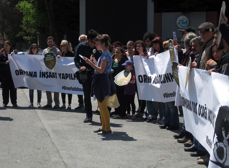
GAAM has published a video showing the ecocide underway for Istanbul’s third airport – an ecocide megaproject. The project site is north of the city on the Black Sea coast. A vast area of forests, lakes, farmland and coastline is being systematically destroyed as the site is prepared for construction. The plan is to build an aerotropolis covering 76 square kilometres. Trees are being felled, lakes filled in and land reclamation damages coastal ecosystems. The aerotropolis plan is linked with other destructive megaprojects including a third bridge across the Bosphorus Strait. Resistance against the megaprojects is led by Kuzey Ormanları Savunması (Northern Forest Defence).


The video was taken on a visit to the site on 7th May 2016, photos can be viewed on Fickr. Istanbul third airport
Earlier that day Kuzey Ormanları Savunması held a protest outside the forest directorate.
Protesting to save Istanbul forests

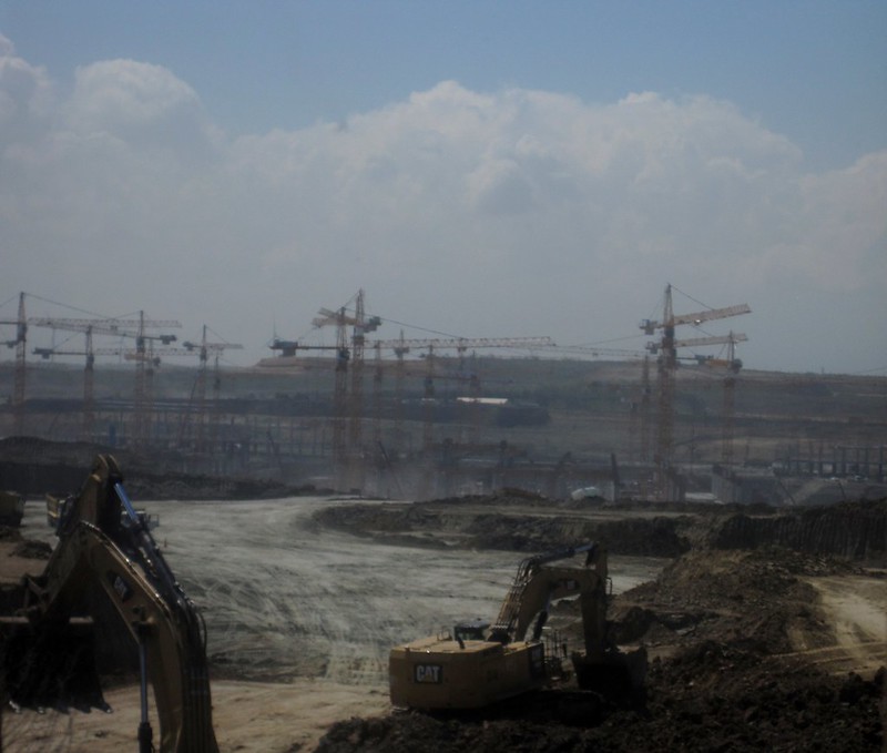
Industry videos of construction of Istanbul’s third airport are available online – giving an indication of the severity and extent of the destruction of ecosystems. The video below, made by Caterpillar shows bulldozing underway.

This video of construction of the airport – on land that used to be forest, lakes and farmland – was filmed from above.