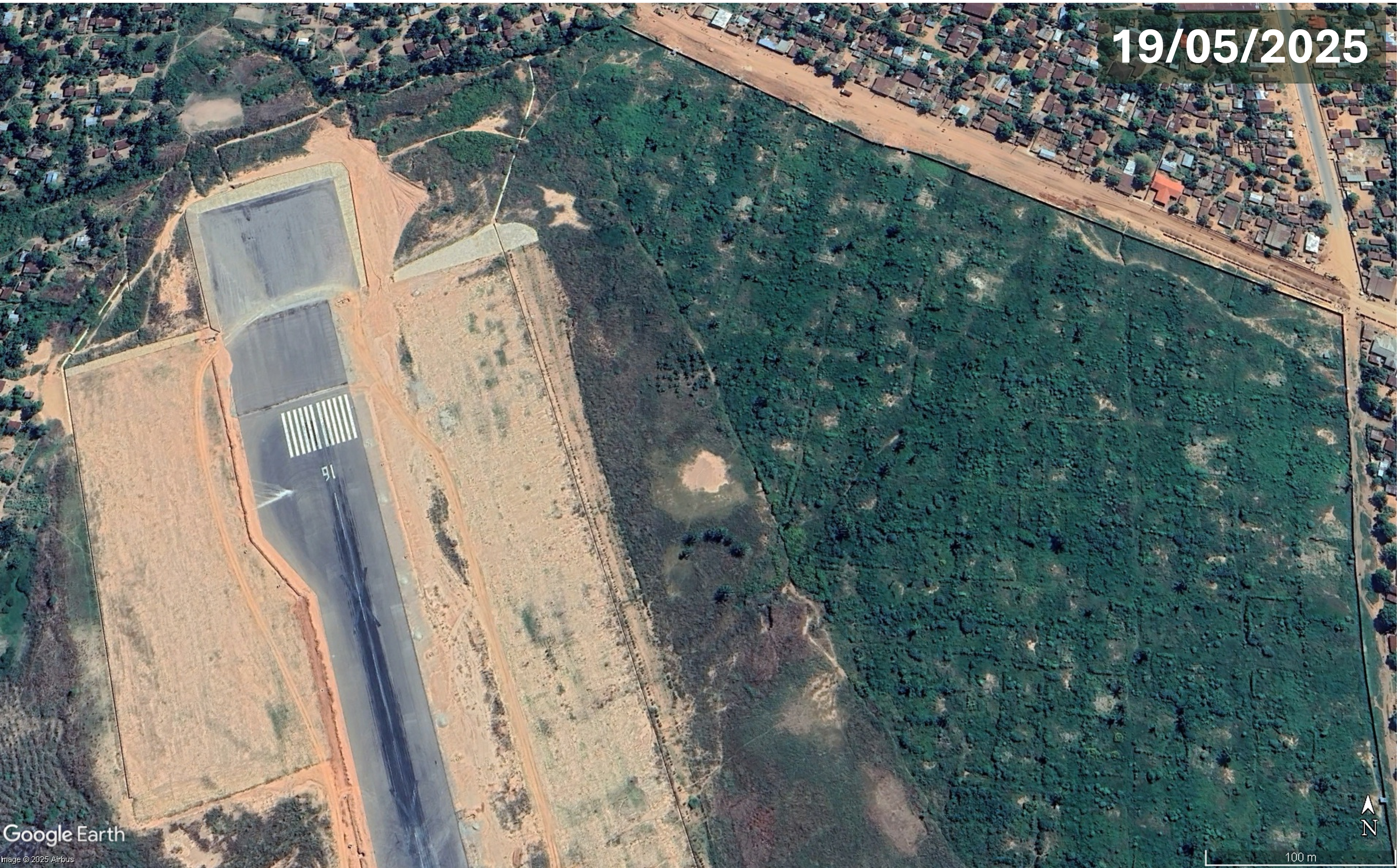
Plans for construction of an airstrip, State Lodge and golf course in the protected Imenti forest, an important elephant habitat and water catchment area, are opposed by many residents and conservation organisations. Felling of mature trees for airstrip construction continued despite conservatory orders to protect the forest and halt the projects.

Reports that allocation of 50 acres of Imenti forest, near Mount Kenya, for an airstrip, State Lodge (regional presidential residence and official venue for state functions and meetings) and golf course, was under consideration emerged in September 2025. Imenti forest, a protected public forest, is a habitat for elephants and many other species, an important water catchment for rivers and streams and is a source of income from agriculture and honey harvesting. Greenpeace Africa immediately opposed allocation of part of the forest ‘for luxury projects’, arguing that it would violate the Forest Conservation and Management Act, the Constitution and be a ‘betrayal of public trust’. The Green Belt Movement called for an immediate halt to the projects, saying the developments would be a misuse of a conservation area, stating, “How does an airstrip qualify as conservation? How does a golf course protect water catchments? How does a State Lodge restore degraded ecosystems? These projects are not necessary. They are luxuries. They are symbols of privilege. They have no place in a protected public forest.” Project proponents claimed that the developments would attract investors, create employment and enable hosting of high-level government events and international visitors but environmentalists warned that a reduction in forest cover would cause soil erosion, disrupt of water flows, reduce biodiversity and facilitate further forest encroachment and ecosystem fragmentation.
The Imenti Development Forum (IDF), a group of professionals involved in conservation and establishing ICT hubs in schools, issued a press statement opposing the plans, stating, “The Imenti forest is not simply trees. It is one of the region’s most significant repositories of biological diversity- a living library accumulated over millennia that, once destroyed, cannot be rebuilt in any human timescale.” Representatives of two political parties also opposed the projects: Party of National Unity leader Peter Munya and Jubilee Party deputy leader Dr. Fred Matlang’l who said another state lodge was unnecessary as the president already has access to high-speed aircraft and safe, modern hotels. North Imenti MP Rahim Dawood had initially favoured the projects but opposed locating a State Lodge in the forest taking up more than 20 acres of land and suggested locating a golf course elsewhere.
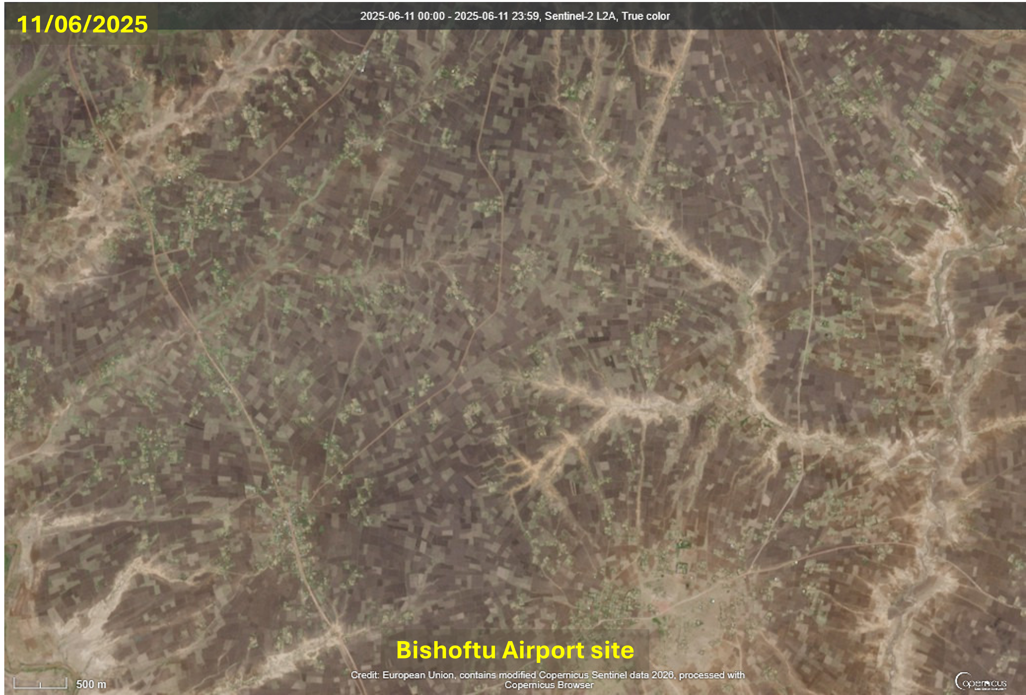
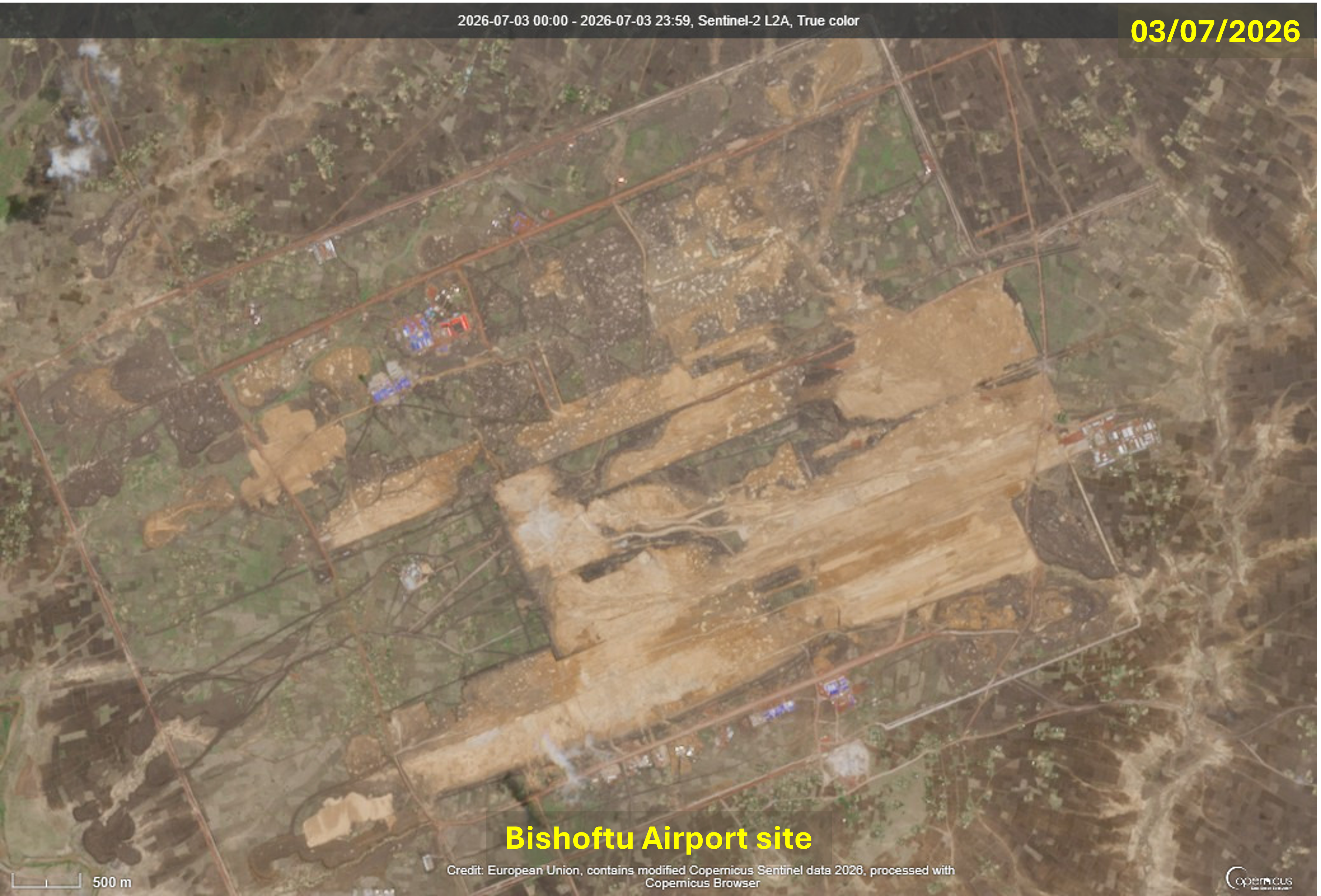
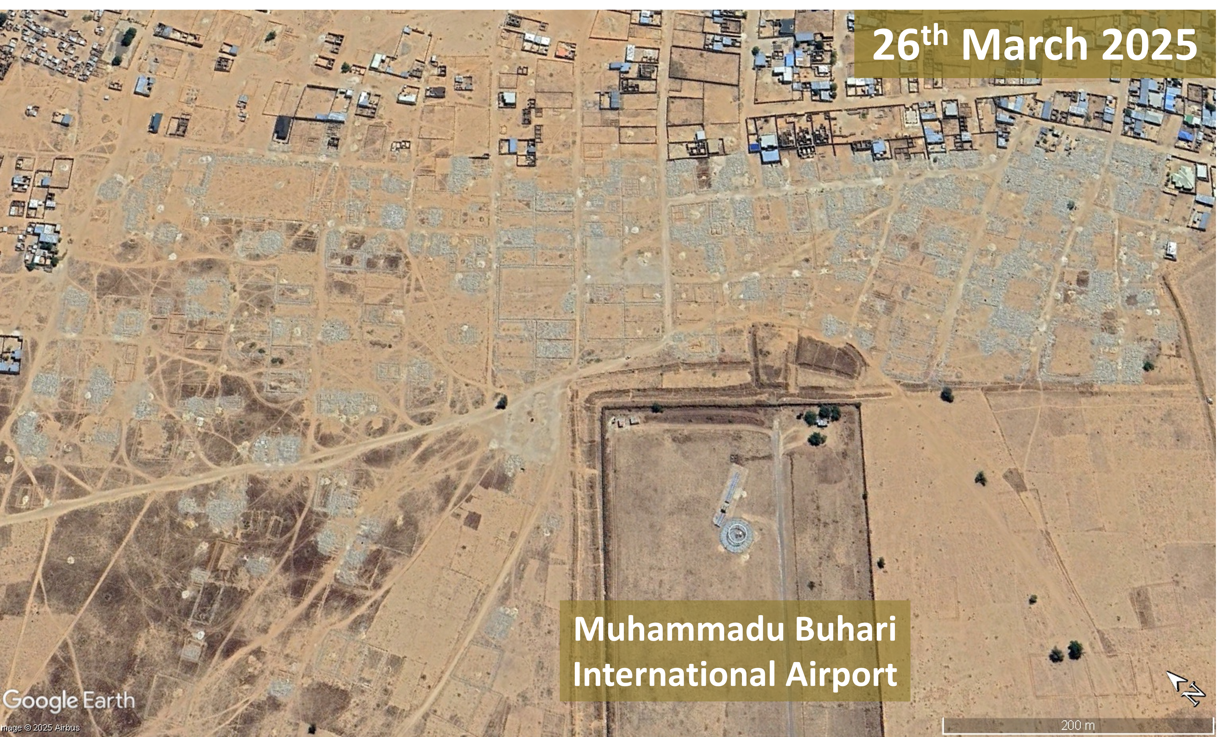
The Meru Environment and Land Court intervened to protect Imenti forest, issuing interim preservation orders pending hearing of a constitutional petition challenging the plans. On 11th June Justice Oguttu Mboya directed maintaining the forest in its current state until a court decision, barring activities that might impact on forest before issuance of further orders. The case was filed by Francis Awino who argued that the projects could cause irreversible damage. He also asked for preservation and disclosure of records connected to the proposed development such as environmental impacts assessments, maps, correspondence, license applications and approvals and planning documentation. The petition stated. “Public forests are held in trust for both present and future generations, and the State bears a constitutional obligation to conserve and protect them.” On that same day machinery entered the Kithoka section of the forest and, protected by security, began felling mature trees. Forestry Principal Secretary Gitonga Mugambi said construction of an airstrip would be completed within a week, by 18th June, with the first plane expected to land on that day. Kenya Forest Service (KFS) rangers had been deployed to guard all entrances to the site and local people entering the forest were frisked to check for smartphones, presumably to prevent recording of activities in the forest.
Conservation charity Rhino Ark issued a statement strongly opposing airstrip construction in the Upper Imenti Forest Reserve and calling on the National Environment Management Authority (NEMA) to suspend works pending assurance of compliance with environmental laws and criticised lack of the public participation, Environmental and Social Impact Assessment ESIA) and a NEMA license authorising the project. Surveys had found that, during the dry season, the Upper Imenti Forest has the highest concentration of elephants in the Mount Kenya area. The airstrip was being constructed within this elephant habitat, close to an elephant maternity area where pregnant mothers migrate to give birth. Greenpeace Africa pointed out that Imenti forest forms part of a wildlife corridor linking Mount Kenya to conservation areas in the north of the country, along which elephants migrate for food, water and mating. Greenpeace Africa said the National Land Commission should “Stop the bulldozers. Respect the court order. Let the elephants keep their dry season home. And prove, for once, that development in Kenya does not have to cost us the things we cannot get back.” The Mount Kenya Trust (MKT) made a statement condemning destruction of part of Imenti forest for an airstrip, maintaining that the project is in violation of Articles 42, 69 and 70 of the Constitution and the 2016 Forest Conservation and Management Act and could undermine Kenya’s commitments to increase tree cover, protect biodiversity and restore degraded landscapes. MKT stated, “We stand with those defending the protection of Imenti Forest and all protected areas for future generations.”


On 24th June Meru Environment and Land Court issued another interim conservatory order to halt construction of the airstrip, in response to a petition filed by five Meru residents. Petitioners said to the court, “The Respondents have failed to disclose Environmental Impact Assessment reports, feasibility studies, approvals, maps, acreage surveys and other statutory documents relating to the project. The proposed development threatens to cause irreversible degradation and destruction of forest resources.” The following day Meru Environment and Land Court certified an application, filed by Francis Awino, seeking to cite senior officials for contempt of court over allegations of continuing destruction of Imenti forest. In the Notice of Motion, Awino stated “Unless the contemnors are immediately summoned to answer for their actions, the authority and dignity of this Honourable Court shall be undermined…The continued and wilful acts of disobedience are causing and/or threaten to cause irreparable prejudice to the Petitioner’s constitutional rights, public interest and adversely desecrate designated forest.” A supporting affidavit alleged that, in defiance of court orders, prohibited activities continued including: granting commercial contractors, earth moving machinery and workers access to the Kithoka section of Imenti forest; felling mature trees, removing forest vegetation and clearing undergrowth to open up a corridor for a runway; bulldozing, grading and levelling works to prepare the forest floor for runway construction; and surveying forest areas for a proposed State Lodge and golf course. Geotagged satellite images, photographs and videos provided evidence of continued forest clearance. A petition filed by Meru Forest Conservation Forum and Pan-African Climate Justice Alliance resulted in a further conservatory order to halt developments in Imenti forest.
Belatedly, a public participation forum on the projects in Imenti forest was held, but it descended into chaos. The Meru Environment and Land Court had suspended the exercise as a change of venue with just 24 hours notice failed to meet the constitutional threshold for meaningful engagement. Defying a court order KFS proceeded with the forum and a group of stakeholders endorsed the airstrip, State Lodge and golf course projects. A lawyer attempting to serve a valid court order was denied access to the microphone and people presenting a petition opposing the projects that had been signed by more than 7,000 people were jeered at, threatened and removed by security officers. The Standard described the forum as ‘not public participation, but more of a staged exercise to endorse a decision that had already been made’. By 15th July 2026 the online petition, Hands Off Nkunga Forest! Stop the Destruction of Meru’s water catchment area, calling for an immediate halt to plans, surveys and budget allocation for the State Lodge, airstrip and golf course, had garnered 7,114 signatures.[17]
For more information including references for all source material, videos and photos see the case study on EJAtlas, the world’s largest, most comprehensive online database of social conflict around environmental issues – Airstrip, State Lodge and golf course in Imenti forest, Kenya