The oil supply crunch reduced deliveries of the vast volumes of diesel required for expansion of Phu Quoc Airport, including a second runway and passenger teminal, plus a luxurious VVIP terminal, scheduled for completion in time for the APEC 2027 forum.
Artist’s rendering of Phu Quoc Airport VVIP terminal as seen from above, resembling a sea eagle. Image: VnExpress
Within days of the US and Israel launching strikes on Iran restrictions on oil shipments through the Strait of Hormuz, a key transit route for diesel supplies to the Vietnamese island of Phu Quoc, had drastically reduced delivery of the volumes required for expansion of Phu Quoc Airport. The ambitious expansion plan aims to increase passenger handling capacity fivefold, from the current 4 million per year to 20 million by 2027 in the first phase, rising further to 50 million per year by 2050. The oil supply crunch had major impacts on construction works. Operation of between 160-180 items of heavy equipment for runway 2 works required 10,000 liters of diesel per day. Earthworks on 2,700 hectares of the runway 2 area, with 130 pieces of equipment, had been consuming about 27,000 liters per day. More than 60 per cent of the equipment had been shut down and 70 machine and vehicle operators temporarily laid off. Tankers carrying 200,000 liters of diesel had been arriving from the mainland every 7-10 days, but since 2nd March the supplier was only fulfilling existing orders and was no longer taking new orders. Yet publicity for the airport expansion continued. On 18th March 2026 Phu Quoc Airport unveiled more details of the VIP terminal design, with graphics depicting an exclusive lounge and luxurious, spacious arrival and departure halls that are markedly different from cramped and crowded facilities for regular travellers, with floor-to ceiling windows giving a ‘sweeping view of the sea’, ‘glossy black obsidian surfaces’, gold accents and a glass and gold sculpture of an eagle ray in flight.
Luxury aviation facilities for APEC 2027
Less than four months previously, on 28th November 2025, rapid progress of Phu Quoc Airport expansion was reported to be an aviation industry record with a second runway, closely followed by the ‘VVIP terminal’, then a second terminal, T2, all on schedule. The expanded airport is envisaged as a ‘gateway’ to a ‘Phu Quoc megacity of the future’ and on 31st December 2025 it was announced that airport construction was moving at an unprecedented pace; the steel framework for the 6,000 square meter VVIP terminal was in place. Initially, the VVIP terminal will host heads of state and high ranking delegations to the 2027 APEC (Asia-Pacific Economic Cooperation) Leaders Week meeting, a key event in the APEC 2027 forum themed ‘Connecting: Building Inclusive and Resilient Economies’. Exclusive facilities are being fast-tracked for an event purporting to promote inclusivity. Both the VIP terminal and Terminal 2 are being built ‘with the aim of delivering luxury standards and a premium passenger experience’. Luxurious passenger facilities will be accompanied by a new luxury airline, Sun PhuQuoc Airways, which ordered up to 40 Boeing 747 Dreamliner planes for international flights to its hub at Phu Quoc Airport. Boeing’s announcement emphasised the aircraft’s ‘superior comfort to passengers’ and described Sun PhuQuoc Airways as ‘well positioned to capture the next wave of premium tourism’. Two mega hotel projects reshaping the skyline to host global leaders and high ranking officials for APEC 2027 are similarly exclusive, designed for ‘diplomatic events, international conferences and high-end tourism’.
Forest land conversion for tourism projects
Conversion of 0.46 hectares of protected forest land for use in Phu Quoc Airport expansion was approved in February 2026. This small forest loss for tourism-related infrastructure is a continuation of a pattern affecting large swaths of the island. Elsewhere on Phu Quoc 286 development projects are planned and, as reported by Mongabay, since July 2024, authorities have permitted conversion of over 180 hectares of forest, most of it categorised as ‘special use’ due to ecological value or scientific importance. A key development, Rạch Tràm Ecotourism and Residential Project on the island’s north coast, required forced relocation of 508 households and clearance of 57.7 hectares of special use forest in Phu Quoc National Park. Development of Phu Quoc as an island tourism city was approved by the Prime Minister in 2022 and the 286 projects, at various stages of planning and development, span over 9,600 hectares, nearly 17 per cent of the island. Legal changes in 2024, expanding the type of developments for which forest land can be converted to include industrial parks and clusters in addition to ecotourism, resorts and recreation projects, facilitated a spike in forest conversion approvals. Since the amendments to land laws conversion of nearly 182 hectares of Phu Quoc forest, 77 per cent of this being special use forest, has been approved and the land designated for tourism projects.
Rendering of Aerocafé Airport, now under construction in Palestina, Caldas. Image source: CPG Click Oil and Gas
Construction of Aerocafé Airport, in the municipality of Palestina in the south central region of the state of Caldas, part of Colombia’s coffee cultivating region known as the Coffee Triangle or Coffee Axis, is underway, The showcase infrastructure project is promoted as an engine for regional growth, anticipated to enable a 12 per cent increase in nature, adventure, cultural and gastronomic tourism. Exports including coffee, textiles and household appliances are envisaged. Yet Palestina residents in the affected area complain of uncertainty, displacement and disputes over compensation. In addition to economic concerns over resettlement the airport project has begun to impact on people’s local networks and sense of belonging. Authorities claim that the project complies with compensation and resettlement procedures. Construction of Aerocafé Airport, among the most complex and expensive in the history of the Caldas Department, is having major impacts on people occupying the area designated for the project. Land is being prepared for construction works and machinery moved in, directly affecting approximately 250 families living near the area earmarked for the runway and other structures. Entire communities will have to vacate their homes, rural property and small businesses. The Department of Caldas, Ministry of Transport and Civil Aeronautics of Colombia stated that affected residents should relocate to a planned neighbourhood providing equivalent or superior housing, with temporary compensation during the resettlement process. But this process necessitates environmental licenses, technical requirements and public hearings that are not yet completed.
These negative impacts on communities directly affected by construction are not what was promoted by the UK Government Prosperity Fund. In 2020 this scheme (a £25.5 million programme running from 2017 to 2022) provided USD1,265,000 for design studies for ‘Aerocafé, An Airport That Champions Economic Inclusion and Gender Equity’, claiming it would incorporate best practices exemplifying the principles of gender equity and social inclusion along with adherence to environmental standards. British Ambassador to Colombia, Colin Martin-Reynolds said, “This project will have a considerable impact on the economic development and livelihoods of communities in Caldas and the entire coffee producing region.” Manager of the Aeropuerto del Café Association, Amparo Sánchez Londoño, emphasised the strategic significance of the airport and foreign investment, saying, “thanks to this international cooperation, we have consultants with extensive experience in the airport sector, adding value to the design of the most important infrastructure project for the economic revival of the region.” Recent news on construction works raises serious concerns that Aerocafé Airport is failing to foster inclusive economic development for directly affected communities, or to support their livelihoods.
Plans for the Aerocafé Airport, originally named ‘Coffee Airport’, first emerged in 1977 but the project met with lengthy delays due to funding and administrative issues combined with engineering difficulties of constructing an airport on steeply sloping, unstable terrain. The site is on a plateau 1,600 metres above sea level which, following cut and grading works, could accommodate a runway more than 3 kilometres in length. In August 2021, during preparation of the site including grading (levelling the site), confirmation of sites for disposal of surplus materials and drainage works, the Civil Aeronautics of Colombia estimated that 5.8 million cubic metres of earth would need to be moved. In October 2024, 47 years after it was first mooted, the megaproject was revived when Aerocafé received a finance guarantee from the Colombian government, which meant that contracting for a further stage of construction works could commence. The investment for first phase of the project, with a 1,460 metre runway, taxiway, hangars, apron and a 6,000 square metre terminal with capacity for 1 million passengers per annum, is 828,423 million Colombian pesos (approximately USD197 million). The finance guarantee from the Ministry of Finance complemented funding from the Federal Government and Caldas State.
Land clearance and consutruction of Gia Binh Airport, on the largest airport site in North Vietnam. is underway. Since approval of the project the projected passenger capacity has risen to 50 million per year by 2050. A VIP terminal is scheduled for completion in time for APEC 27.
Aerial imagery of Gia Binh Airport site. The image on the left shows the site on 26/04/2024 before construction works began. The image on the right, dated 17/07/2025, shows land cleared for runways and other airport infrastructure.
A major new airport in Gia Binh, about 40 kilometres east of Hanoi in a rural area of Vietnam’s Bac Ninh province, was approved by the Ministry of Transport in February 2025, with capacity for 1 million passengers annually by 2030, rising to 3 million by 2050. By April the planned capacity had been adjusted upwards to 5 million passengers annually by 2030 rising to 15 million by 2050. In July the size of the airport project was scaled upwards again, to handle 30 million passengers per year by 2030 then reaching 50 million by 2050. Since publication of the original plan the projected cargo volume had more than doubled, from 250,000 tons annually by 2030 growing to 1 million tons by 2050 to 1.6 million tons by 2030 growing to 2.5 million tons by 2050. With its site enlarged nearly fivefold, from an initial 408.5 hectares to 1,960 hectares, Gia Binh Airport is now set to be northern Vietnam’s largest airport, bigger than Noi Bai Airport and Tan Son Nhat Airport, exceeded only by the 5,000 hectare site of Long Thanh Airport in the southern Dong Nai province.
In August the government approved special mechanisms fast tracking investment and construction processes for the airport, related works, land clearance and resettlement, exempting projects from construction permit requirements and approving conversion of rice crop land. About 920 hectares of rice fields yielding two crops per year will be converted for the airport. Land allocated for the Gia Binh Airport site comprises about 1,184.78 hectares of agricultural land, 415 hectares of non-agricultural land, 159.4 hectares of residential land and 124.8 hectares of land utilized for defence and security purposes. Land acquisition will affect approximately 7,100 households and individuals and 118 organizations. About 5,800 households and individuals will have to relocate and resettle. The number of graves that will be moved is estimated at 18,800 but this does not include unidentified graves. Development of Gia Binh Airport is triggering one of the largest land clearances in recent history.
Schools and hospitals along with infrastructure such as irrigation systems, canals, pumping stations and power transmission lines will also have to be removed to make way for the airport and rebuilt elsewhere. About 25 historical and cultural sites must also be relocated as part of land clearance for the airport. By mid-November initial groundworks for construction of the airport and development of supporting infrastructure were underway. Heavy machinery was operating continuously to level the airport site and barriers and signs restricted access to construction zones. The provincial government had paid more than VND1,990 trillion (USD81 million) in compensation to 4,045 households in the Gia Binh, Nhan Thang and Luong Tai communes, accelerating clearance of more than 436 hectares of land. Clearance of agricultural plots of land was scheduled to be finished by 30th November with resettlement areas due for completion by 15th December.
Gia Binh Airport will accommodate large, wide-bodied aircraft including the Boeing 777 and Airbus A330 and plans specify four runways upon completion by 2050. The investment requirement is estimated at VND 196.37 trillion (USD7.5 billion). As well as becoming a major aviation hub the airport project will open up land surrounding it for development including hotels, airport-adjacent hospitality, and airport city projects. The Ministry of Construction had considered expanding Noi Bai Airport southwards, but this would have necessitated relocation of large communities and incur high land clearance costs. With larger land reserves and more space for development than Noi Bai Airport, the government expects Gia Binh Airport to accelerate growth of industry, logistics, e-commerce and tourism.
In addition to dual-use function as a civil and military facility with a strategic role in national defence Gia Binh Airport is designed to support major diplomatic events, in particular Vietnam’s hosting of the 2027 Asia-Pacific Economic Cooperation inter-governmental forum, APEC 2027. Elite APEC officials will be among the first passengers to arrive at Gia Binh Airport; a ‘soft opening‘ in time for APEC 2027 is planned, with one runway operational along with the air traffic control tower and a VIP terminal. Many key APEC 2027 events, most notably the annual Leaders’ Summit, will take place on Phu Quoc, Vietnam’s largest island located near the south coast of Cambodia, which is rapidly developing as a luxury tourism destination. Fast-paced expansion of Phu Quoc Airport to support APEC 27 Leaders’ Week is underway. One of the high-priority projects is a VIP terminal to welcome heads of state and high-ranking delegations to the APEC 27 leaders’ meeting. Longer term plans for Phu Quoc Airport expansion aim to increase passenger capacity from the current 4 million to 50 million by 2050.
Long Thanh Airport, under construction in the Đồng Nai Province, is slated to be Vietnam’s biggest airport. With a 5,000 hectare site and costing USD16 billion the airport is designed to have capacity to handle 100 million passengers and five million tonnes of cargo per annum. High levels of dust pollution from levelling Long Thanh Airport construction site, caused distress and posed health risks for neighbouring communities. Between April and October 2022 inspections by Đồng Nai Department of Natural Resources and Environment found dust pollution at the site up to 18 times higher than permitted levels. Levelling works entailed digging up and filling and flattening vast volumes of soil and trucks carrying soil on the site stirred up clouds of dust. In December 2022 more than 1,800 vehicles and machines were operating on the airport site. By the end of March 2023 residents of neighbourhoods near Long Thanh Airport construction site had been shrouded in dust for several months. Satellite imagery dated 13th March 2023 showed progress of the levelling works.
Long Thanh Airport site 13/03/2023. Image credit: Esri, European Commission, European Space Agency, Amazon Web Services
One place worst affected by dust was the primary school at the heart of the Binh Son Commune. Doors were kept closed for the entire day but dust still seeped in. “It’s impossible to clean” said a school security guard, “the dust is everywhere and comes at all times.” A teacher at the school said pupils’ books were “terribly dirty”. Pupils’ hands were always red and they were not comfortable with wearing face masks. Ten people cleaned the school three times every day but dust got into every corner. Some households attempted to keep dust out with canvas tarpaulins or plastic sheeting. A local resident said before airport construction started air quality in the area had been good, but now it was “unbearable”. Another resident said it would be another two of three years until the airport is completed and they “could not bear the red dust”. The deputy chairman of the Vietnam Lung Association said exposure to dust on a daily basis can severely affect people’s health, causing damage to the lining of the respiratory tract or leading to pneumonia, lung infection or pulmonary fibrosis.
Green roofs were coated in red dust and residents spoke of dust on every surface. Farmers in Binh Son Commune grappled with pervasive red dust from the airport construction site. Dust had stuck to mangosteen and rambutan leaves just as the trees began to bear fruit. One farmer said his durian trees had not developed properly and more than half of the fruit had fallen. He and other farmers attempted to wash their trees, spraying them with water which was of limited effectiveness. Another farmer cleaned his trees from 2am to 8am each day, consuming a lot of water and electricity. Other crops were affected, including jackfruit, lychee, banana and sapodilla. Red plumes rose like fires from the construction site and dust was carried by the wind, turning the sky red and impacting on people living at some distance from the construction site, including in the Loc An-Ninh relocation area, a resettlement site for people displaced to make way for Long Thanh Airport. A blanket of dust hung in the air extending as far as 10 kiometres from the site.
A video filmed on the airport site in March 2023 shows a red dust ‘tornado’, a large, dense, rotating plume of dust. You can hear the rumbling sound of the tornado. Clouds of dust are generated when a bulldozer pours red soil into a truck. Footage from a moving vehicle shows areas of the site under a heavy haze of dust and trucks pumping water onto part of the site.
Efforts to address the dust problem, such as spraying water and deploying trucks to dampen the ground to reduce airborne dust, had been ineffective. Officials noted that the size of the site, the dry season and windy weather exacerbated the dust problems. Beginning in April 2023 dust mitigation measures were increased with construction of 10 reservoirs, each with capacity to store 3,200 cubic metres of water, to supply water for 60 trucks including two firefighting trucks. It was also announced that air conditioners would be installed at some schools near the construction site, to prevent dust from entering classrooms.
For more information see the case report on EJatlas, the world’s largest, most comprehensive online database of social conflict around environmental issues: Dust pollution from Long Thanh Airport construction, Vietnam. In April 2023, after publication of the case study, ACV was fined VND180 million (US$7,670) for dust pollution during construction of Long Thanh Airport, plus an additional fine of VND90 million (US$3,835) for failure to implement the environmental impact assessment report.
In 2003 construction of an international airport in Sikhuphe, Swaziland was initiated by King Mswati III, who rules the country as sub-Saharan Africa’s last absolute monarch. From its inception commentators warned that the new airport was a waste of resources, diverting funding away from vital projects to fight poverty in Swaziland. In contrast with the one in seven of the coutnry’s inhabitants living in abject poverty King Mswati III enjoyed a lavish lifestyle with 13 palaces, fleets of luxury cars and a private jet.
September 2021 satellite imagery of King Mswati III International Airport and some of the surrounding road network
In March 2014, presiding over an expensive opening ceremony, King Mswati III unveiled the name of the new airport: King Mswati III International Airport. In the lead up to this event he had announced that a new town would be established to support the new airport, which would bring development to the surrounding communities, including Mbadlane, Hlane and Malindza. He proclaimed “After a radius of about five kilometres from the airport, urban structures will be constructed.” More than three years later, in October 2017, the Times of Swaziland reported that King Mswati III International Airport had ‘brought nothing but misery to hundreds of residents of Sikhuphe, in Malindza, where the airfield was constructed’. They had not received any compensation for their relocation, despite a consultant’s recommendation that a sum of approximately US$6 million be allocated for resettlement of 188 homesteads falling within the boundary of the so-called ‘airport city’.
There was a series of protests over impacts of airport and road construction and lack of compensation in 2021. In September, Malindza residents protested disruption of their water supply caused by construction of a road serving the airport, and demanded its restoration. They had been left struggling to access water to sustain their cultivation of vegetables and rearing of livestock after a dam was destroyed by Inyatsi, a firm with close connections to the government which was awarded construction contracts for King Mswati III International Airport along with a major highway connecting South Africa to Mozambique via the airport. In November a group of about 200 residents blocked Inyatsi’s trucks from entering the quarry near King Mswati III International Airport. It was their third protest in three months. In November 2021 some of the residents of Malindza who were displaced to make way for the project and whose houses were damaged by blasting works during construction – of the airport and road leading to it – were still demanding compensation. Blasting had caused cracks in their houses. A group of residents, mainly women, protested for almost a week and camped in the bushes. They had lost patience after struggling for compensation for almost 20 years.
Over 200 residents slept in the bushes demanding compensation for damage to their housesduring construction of King Mswati III Airport. Photo: Swaziland News, 12/11/2021
This case of airport-related injustice is documented on EJAtlas, the world’s largest online database of social conflict around environmental issues: King Mswati II International Airport
In the early days of the Covid-19 pandemic, on 15th April 2020, officials from the Indonesian government and the East Java province attended a virtual groundbreaking ceremony for a new airport in the Kediri regency. The event marked the official start of construction works that had actually begun three months earlier in January when heavy machines were levelling soil, following several delays that were partly caused by some affected residents refusing to release their land for the project due to unpaid compensation. Fewer than 20 families, in the villages of Bedreck and Bulusari, remained in the area. A villager told The Jakarta Post “If we accept the price, we won’t be able to buy land and build a house of similar value to what we have now”. She said none of the villagers wished to hamper development of the airport, they simply wanted fair compensation. The Kediri administration said that only 0.6 per cent of the 400 hectares of land required to build the airport had not been acquired.
Kediri Airport site area, April 2018
Kediri Airport site area, satellite imagery, June 2020
Kediri Airport site area, satellite imagery, November 2020
The Kediri Airport project (also referred to as Dhoho Airport) was approved in 2018. The first of the satellite images above shows the airport site area in April 2018, consisting of villages and farmland. The second image shows the same area in June 2020 after earthworks had levelled large areas of land. The third satellite image is from November 2020, by which time earthworks had progressed and impacted upon a larger area, transforming the landscape from verdant green to a pale expanse of crushed and compacted rock. Adjoining this area, extending to the southwest, additional earthworks and construction of roads can be seen. This airport-adjacent development is shown in the fourth and final image in the slideshow, a graphic of the Kediri Master Plan visualising a future tourism and residential complex in this area. Produced by ARKDESIGN Architects and Planners, the ‘MASTER DEVELOPMENT PLAN, PLANTATION RESORT & RESIDENCES’ shows two commercial development areas, a warehouse, utility complex and parking adjoining the airport terminal and cargo buildings. Extending to the southwest is an area allocated for hotels, residences and various tourism facilities including five lakes. Progress of construction of the one of these artificial lakes, near the centre of the planned development, can be seen in the satellite images. The graphic indicates proximity to Mount Wilis, a solitary volcanic massif amidst the surrounding low-lying plains. The route of a future toll road is shown extending from the southeast of the project site, between the airport and the adjacent development.
Controversy over land acquisition for Kediri Airport dates back to 2017, when residents, aware of large-scale land acquisition, questioned whether it was a government or private project. In March 2019 residents of one of the affected villages, Jatirejo, hung dozens of banners along village roads, stating their refusal to accept the prices offered by land buyers for agricultural land, that they said were too low. In October 2019 37 head of family residents of Bedrek Selatan hamlet, Grogol village, had not released their land for the airport project as they had not agreed compensation. The airport plan had caused the price of land around the project site to soar. Land prices had also gone up in Bulusari village where some residents were confused over where to relocate to. Some who had received compensation were experiencing difficulties in finding places to relocate to because of soaring land prices. A shift in the location of the airport runway had required acquisition of additional land, leaving residents with difficulties finding land to relocate to. In January 2020 45 residents of Grogol village rejected land acquisition, protesting over a drop in the compensation offer that would only be sufficient for them to buy land in far away suburbs. Residents’ coordinator said they were being pressured to give up their land for the airport. In February 2020, just two months before the groundbreaking ceremony, some residents had still not agreed to the compensation offers for land acquisition. Ten families were refusing eviction because, while the price of land in their village had dropped drastically, the price of land in new locations where they might settle had risen; they faced the prospect of a huge loss. A resident of Bedrek spoke of repeated visits by land buyers over several months and being pressured to accept the price offered for land.
At the time of writing some residents are still unwilling to leave their homes and suffer the impacts of airport construction works. Several villages – Tarokan, Tiron, Bangkan, Jatirejo and Grogol – have been demolished for the airport project and most of the inhabitants had left. Tugiyem, one of few villagers remaining in Mbandrek Selatan, spoke in the midst of swirling dust and roaring engines of construction vehicles, staring at a pile of dredged rocks. She had lived there since the 1960s and used to work gazing livestock, but her animals were left dying as the construction company had fenced off the land and she could not reach them. A metal fence erected on one side of Grogol, ostensibly to deter trespassing and reduce pollution from construction works, limits residents’ access to their village. One of the main roads connecting Grogol village has been blocked off to aid construction works. This had forced farmers taking their crops to the city to take longer routes and food stalls and shops near the road had to shut down. Within a month of closing access to the road four shops had gone bankrupt. Owners of surviving shops have to rely on custom from their neighbours, including Siti Anggirawan who was forced to close her textile shop. Waiting for customers outside her grocery store, Sri Katun said air quality in Grogol had deteriorated, “When a strong wind blows, construction dust drifts into the house. I often cough.” But she had no thoughts of giving up the land she had bought after years of saving up money, saying, “This house is witness to my ups and downs alongside my husband. We want to die on this land that has been part of our history.”
Earthworks for the airport project consisted of a cut and fill excavation up to 35 metres high. Rivers are being diverted away from the runway via two enormous box culverts, one 570 metres in length and the other 470 metres, made from reinforced concrete. A 3,300 metre runway is being built, to acommodate the largest world’s largest aircraft such as the Boeing 777 and Airbus A350. Construction of the airport proceeds even though plummetting air traffic since the start of the Covid-19 pandemic casts doubts on the feasibility of traffic predictions. And the projections for Kediri Airport, as reported in ACI World Airport Development News, Issue 4 2020, are ambitious. Upon completion of the first phase of construction, scheduled for April 2022, Kediri Airport is projected to handle 1.5 million passengers per annum, eventually rising to more than 10 million annually. A Transport Ministry offical said Kediri Airport would serve domestic flights for tourism, and might also be used for cargo related to possible future agricultural and industrial activity in East Java. Kediri Airport is the first in Indonesia to be fully funded by the private sector. Tobacco company Gudang Garam will spend up to USD732 million to acquire 457 hectares of land and a subsidiary, Surya Dhoho Investama, will oversee development of the airport.
Amazon’s expansion of its e-commerce logistics network, giant distribution and fulfilment centres, continues during the Covid-19 pandemic. Several new facilities are airport-adjacent and many are supported by tax breaks.
Online buying has surged during the Covid-19 pandemic. Confinement of American citizens to their homes under ‘shelter in place’ orders and closure of shops selling non-essential goods have been a gift to e-commerce firms with extensive home delivery networks. E-commerce spending in the US surged by 78% in May, with Amazon, Target and Walmart reporting soaring online sales. Amazon, expanding its market share to nearly 40% of all online sales, has been the biggest winner. The first week of July 2020 marked the twelfth straight week of over 60% year-on-year growth of customer spending on Amazon. And Amazon is consolidating its distribution dominance by adding to its existing large facilities at airports, strategically located in proximity to fulfilment centres (warehouses for receiving and processing orders). A fleet of trucks, estimated to number over 20,000, delivers products and packages to urban centres.
Amazon’s surface shipping network is supported by Amazon Air (formerly known as Amazon Prime Air), a wholly owned subsidiary of the retail, e-commerce and logistics giant. Growth of Amazon Air is accelerating in 2020 and is a cornerstone of Amazon’s drive to challenge the dominance of FedEx, UPS and the United States Postal Service (USPS) in the overnight and 2-day home delivery market. Amazon’s fleet of cargo aircraft is anticipated to grow from 42 at present to 70 by 2021. A fleet of this size would place Amazon Air, its route network almost entirely within North America, among the world’s largest cargo airlines.
Amazon ‘super hub’ at CVG
A massive new air hub at Cincinnati/Northern Kentucky Airport (CVG) appears to be the lynchpin of Amazon’s expansion of domestic deliveries across the US. The new facility is expected to handle 200 flights per day, becoming Amazon Air’s ‘super hub’. Construction has caused problems for neighbouring homes and business premises. For more than a year vibrations from blasting works during construction caused damage to buildings along with uncontrolled dust and noise. Two affected residents filed a complaint seeking to allow residents living within 1 mile of the site to file a class action lawsuit against the contractors building the air hub. A construction worker, Loren Shoemake, was killed in a accident on the site. $40 million in state and local tax incentives and an additional $5 million from CVG Airport were given to Amazon to develop the air cargo hub at CVG and the State of Kentucky built a new interchange on the Interstate-275 highway to serve the development.
Amazon’s growth is partly due to its agressive stragetegy for getting tax breaks. Amazon Tracker, created by Good Jobs First, a non-profit organisation focusing on government and corporate accountability, tallies tax breaks and other subsidies given to Amazon for warehouses, other distribution network facilities and data centers. At the time of writing the total amounted to $2,982,000,000. Amazon facilites at airports benefitting from subsidies include hubs at Lakeland in Polk County, Florida and Will Rogers World Airport, Oklahoma, and distribution centres at Charlotte Douglas Airport in North Carolina and Romulus, Michigan.
Charlotte City Council approved $13.4 million in incentives to Amazon to bring an Amazon facility to Charlotte Douglas Airport. Opening in September 2019, the distribution centre has a footprint of 855,000 square feet, about the size of 15 football pitches. An identically sized Amazon fulfilment centre, on 84 acres of land in Romulus, north of Detroit Metropolitan Airport, was granted a $5 million state subsidy from the Michigan Strategic Fund in 2017. In addition $13.5 million of Michigan tax dollars was allocated for infrastructure around the site. The director of the Detroit Regional Aerotropolis Development Corporation said Amazon would attract other transportation and logistics firms to vacant property near the airport. Efforts to develop 6,000 acres of land within Detroit Regional Aerotropolis began in 2007 but never took off.
During 2020 Amazon has continued expansion of its surface shipping network, constructing and leasing massive warehouses across the US, in several instances supported by tax breaks and state funding for associated road infrastructure. In June 2020 the town of North Andover, Massachusetts, approved an estimated $27 million in tax incentives to Amazon for a massive 3.8 million square feet, five-storey high distribution centre. A tax increment finance agreement will reduce Amazon’s property tax bill for a decade. The amount is almost equal to the combined total of tax breaks previously granted to the company for other facilities in Massachusetts in the past few years: $16 million in state and local tax incentives for a large distribution centre in Fall River, an estimated $3.5 million for a sortation centre in Stoughton and up to $10 million in property tax breaks from the city of Boston for new offices in the Seaport District. The 110 acre North Andover site, formerly an industrial complex, is adjacent to Lawrence Municipal Airport with easy access to two interstate highways, the I-495 partial beltway around Boston and the I-93 arterial road extending from southwest Boston to St. Johnsbury, Vermont.
Site of new Amazon distribution centre in North Andover, Massachusetts
Over in Ohio construction of an Amazon fulfilment centre with a 2.8 million square feet footprint in Rossford, Wood County, was nearing completion by the end of June 2020. Interior works on robotics and HVAC (heating, ventilation and air conditioning) were underway and the scope of the project had expanded; 300 parking spaces for tractor-trailers in initial designs had increased to 719. Also in Ohio, state funding for a road project in Etna Township, Licking County is related to an Amazon building. One of the biggest speculative developments in the country, the footprint is reportedly 1.2 million square feet. The 15th June 2020 meeting of the Ohio Controlling Board approved release of $800,000 in support of the Amazon project, to extend a road “needed for basic access to the facility.” The 85 jobs that will be created by the road project come at the expense of a hefty subsidy: $9,411 per job. State largesse for Amazon was the polar opposite of swingeing $850,000 cuts to the nearby Southwest Licking School District, part of statewide budget cuts announced in May.
Map showing site of Amazon speculative building in Etna Township and road funded by Ohio Controlling Board. Source: Newark Advocate, 11th June 2020
More Amazon facilities in California
Imminent opening of a large new Amazon distribution centre at Meadows Field Airport in Kern County, California – a four floor facility with a footprint measuring 640,000 square feet – was announced in June 2020. Kern County agreed to give Amazon $3 million in local tax rebates in 2018, a subsidy package that would award the company annual refunds of approximately $275,000 for more than a decade.
Speculation that Amazon is developing a western hub at San Bernardino Airport was confimed on 8th May 2020 when the tenant of a major new air cargo facility was announced and the project named Amazon Air Regional Air Hub. Up until this point the tenant of what had previously been called the Eastgate Air Cargo Facility had not been disclosed. Amazon has already built 14 giant fulfilment centres in the San Bernardino and Riverside communities, known as the Inland Empire and one of the biggest hubs for goods warehousing and distribution in the US. High levels of air pollution from logistics traffic is compounded by geography; the area sits in a valley between two mountain ranges, forming a bowl trapping pollutants and emissions drift inland from Los Angeles. Several studies link poor air quality to health problems.
Eastgate Air Cargo Facility site plan showing distribution and office building, aircraft parking areas, dock doors, parking and operational support areas. Source: Environmental Science Associates, Inc., July 2019
More air cargo flights at San Bernardino Airport will bring more trucks, more traffic and more pollution. Specifications for the air cargo facility include two new driveways into the site with two new bridges crossing the City Creek Bypass Channel. Hundreds of local residents attended meetings to raise concerns over pollution from air cargo flights at the new San Bernardino Airport facililty and the projected 1,568 diesel-fuelled truck trips per day. A coalition of residents, community organisations, labour unions and churches united under the San Bernardino Airport Communities banner to push for good jobs during construction and operation and protection from air pollution, noise and road traffic impacts.
Two local community groups in Sonoma, Northern California, called for public input on a proposal to lease a vast warehouse to Amazon for its North Bay delivery hub project, questioning whether the turning the space into a major regional delivery centre violates the terms of the permit for the building. The property is zoned for light manufacturing, research and development, warehousing and distribution or retail/office use. Norman Gilroy of Mobilize Sonoma and Kathy Pons of the Valley of the Moon Alliance raised concerns that operation of a major regional delivery centre will increase intensity of the building’s use, without planning review or public comment, enquiring about the number of vehicles that will enter and leave the building on a typical day. The facility is anticipated to open in the autumn. In June 2020 neighbouring residents, concerned when they noticed a large crane at work, alerted county officials. An inspector verified that no permit for the work existed, leading to issuance of a ‘stop work’ order and a fine.
Houston, Florida, New York, Connecticut
Construction of a massive Amazon warehouse just southwest of Houston began in June 2020. The new fulfilment centre, on a 93.5 acre site, will have an 855,000 square feet footprint. Amazon built its first facility in the area, in north Houston, a few years ago, receiving a 10-year tax break from Harris County that was expected to save the company $180,000 annually. Elsewhere in the Houston area Amazon also has a fulfilment centre in Brookshire and a sorting facility near George Bush Intercontinental Airport. In central Florida the aforementioned Amazon air cargo hub at Lakeland Linder Airport is taking shape, a 300,000 square foot, three storey building taking up 47 acres of airport land. Then in July Amazon secured approval to build what might be its largest distribution facility in South Florida, near the Homestead Air Reserve Base in south Miami-Dade.
Site of new Amazon distribution centre in Miami-Dade
In New York, work on Amazon’s 450,000 square foot last mile facility in Bloomfield, Staten Island was deemed essential construction during the Covid-19 pandemic. Amazon already has a facility in Staten Island, an 855,000 square foot distribution centre opened on the West Shore in 2017. On 23rd June Amazon inked an agreement to lease space for an even bigger facility in Queens. A disused containerboard factory will be demolished and replaced with a massive 1 million square foot four-storey warehouse which will be the largest in New York City. Simultaneously, steel girders were being erected for an Amazon distribution centre in Clay, a town in Onondaga, a northern suburb of Syracuse. Upon completion, scheduled for autumn 2021 in time for Christmas deliveries, the five-storey, 3.8 million square foot facility will, in term of floorspace, be one of the largest in the world. Jobs will be created, but mainly for robots. Employing just 1,000 people it will be one of Amazon’s most automated sites. Little remains of the golf course that previously occupied the site, for 73 years. Onondaga County Industrial Development Agency approved $70.8 million in tax breaks for this Amazon distribution centre project.
On 26th May 2020 a second Amazon warehouse/distribution centre in Windsor, Connecticut received local land use approvals. The 147 acre hub will be built on former tobacco farmland. Amazon, aiming to start construction in the third quarter of 2020, sought multi-year tax breaks for the development. Windsor’s economic development commission obliged, recommending approval of a seven-year 100% cent tax abatement. The site is on the Bradley Airport Connector highway connecting Bradley Airport with Interstate-91, the major north–south transportation corridor in central Connecticut.
Map showing site of new Amazon warehouse in Windsor, Connecticut, next to Bradley International Airport and connector highway
The tax breaks for the new Amazon facility, approved by Windor town council, were more modest than had been suggested: a three-year 50% abatement of real property taxes plus a 50% reduction in building permit fees. Amazon is projected to net savings of $8.78 million from the deal. Good Jobs First expressed its opinion on granting tax incentives to Amazon in a tweet:
Town gives $8.8 million in incentives to #Amazon, which had already started construction on the fulfillment center being subsidized. It's economic development malpractice to subsidize a project you've already landed. https://t.co/2xGkARQ6A0
On 22nd June Amazon decided to open two distribution centres in the south suburbs of Chicago, in Matteson and Markham, each measuring 855,000 square feet and anticipated to employ 1,000 people. The low employment density ratio is partly due to automation; the facilities will use ‘the newest generation of Amazon robots’ to pick, pack and ship goods. Several officials said Amazons’ decision to locate the warehouses in Matteson and Markham strengthened the case for proceeding with the long proposed south suburban airport in Peotone, as an air cargo hub. The new Amazon facilities are within a few miles of the airport project site. Government funding for road construction linking to the airport site is already allocated: more than $205 million from the Rebuild Illinois infrastructure plan for construction of Interstate 57 (I-57) related to the airport property. David Greising, president and Chief Executive of the Better Government Association, wrote that area would be better served with road and bridge upgrades serving rail and trucking routes than by ‘sinking $205 million into an “airport to nowhere” off I-57 toward Peotone’.
A third major Chicago region airport, on farmland in Peotone, has been proposed since the 1980s. Illinois Department of Transportation started buying land surrounding the site in 2002, amassing 5,000 acres of the proposed 6,000 acres for the ‘inaugural footprint’ for the airport. Farmer Judy Ogalla, who owns land in the proposed airport site where she grows corn, soybeans and wheat, said “We have great soil…It doesn’t have any sense to pave over that when we have an airport in Gary.” Kevin Brubaker of the Environmental Law and Policy Center said construction of the airport would destroy 1,200 acres of flood plains and 180 acres of wetlands. Opposition to Peotone airport has been sustained by Shut This Airport Nightmare Down, a group composed of environmentalists, farmers and other residents.
Amazon’s cloud cluster, data centres housed in another set of ubiquitous grey warehouses, casts an ever heavier earthly footprint. Already Amazon operates more than 50 data centres in Loudoun County, Northern Virginia, the largest single concentration of corporate data centres on the planet. Amazon seeks to expand this by building a massive, 2.5 million square feet, data centre campus south of Dulles Airport. This is one of five potential Amazon data centre projects being developed as the cloud cluster becomes a ‘cloud corridor’. Amazon and its development partners have been land banking, buying parcels of land for future development, adjcacent to Dulles Airport. Some Loudoun County community members are critical of data centre design and location. Over 100 data centres lining major roads dominate the visual landscape and lead to tensions over noise in residential neighbourhoods.
GAAM is delighted to share an incredibly informative set of maps elucidating the complex socio-economic and environmental impacts of construction of New Mexico City International Airport (NAICM). The maps were produced by GeoComunes, a collective working with communities to use maps as an analytical tool to strengthen the struggle for defence of common goods, in collaboration with affected residents and NGOs supported by Coordinadora de Pueblos y Organizaciones del Oriente del Estado de México (CPOOEM), which supports people’s defence of land, water and culture in eastern Mexico. The NAICM site, covering over 4,431 hectares, is the waterlogged Texcoco lakebed. Aerotropolis development is planned: a specific area within the airport site and commercial and industrial development over an extensive area surrounding it.
The first map, below, shows uncontrolled urbanization between 2000 and 2015, preceded by highway expansion, driven by real estate and encroaching on ejidos (communally held agricultural land) near the shores of Texcoco Lake. Landfill sites receiving waste from Mexico City have damaged farmland and polluted aquifers. The airport site is in the ‘Zona Federal’ area in the centre of the map. The existing Mexico City International Airport (officially named Benito Juárez International Airport) is shown near the bottom of the map.
A perimeter fence has been erected around the NAICM Phase 1 project area. The site includes ejidal lands, in spite of assurances that the airport would be built entirely on federally-owned land. Ejidal lands were also appropriated for a highway and housing developments, and many Ejidos (land holders) were violently evicted by state security forces. Plans for Aerotropolis phase 1 include a shopping mall, hotels, industrial park, exclusive high-end housing, golf courses and a free trade zone.
The third map shows satellite imagery of the three Ejido areas directly affected by airport construction. Over 330 hectares of ejidal lands, in the communities of Ixtapan, Nexquipayac and Atenco, were seized from its rightful owners by the government and now lie within the NAICM perimeter fence.
Land-levelling to prepare the site for construction of the airport involved clearing saline sludge from the lakebed and toxic waste that has been dumped, polluting the Texcoco aquifer and damaging farmland. Extraction of materials for use in has had a devastating impact on sacred mountains, in the Valley of Mexico. Blasting with dynamite has damaged, forests, biodiversity, springs and archaeological remains. It is estimated that 64 million tonnes of tezontle (red volcanic rock) along with stone and other materials, carried on 400 trucks per day, will be deposited to fill in the Texcoco lakebed.
Water drained from the Lake Texcoco area will be channelled into Nabo Carrillo, an artificial lake and newly created lagoons, along with water from the area east of the airport site channelled via several culverted rivers. Lying at the bottom of a downward slope the airport site is at risk of flooding from concentration of water flow in this area. The flood risk could become more severe as Texcoco lakebed is sinking at a rate of about 12 inches annually.
An extensive road network linking NAICM to key urban centres is planned and under construction, encroaching on ejidal land and opening up additional land for real estate and commercial development. Many of the roads are toll roads which will generate profits for construction firms holding the concessions and thus set to benefit from the traffic flow.
Data from all the maps is combined in the final map, which covers a wider geographical area revealing the extent of the urbanization that is underway and planned. See the larger version of the map for more detail. NAICM is shown within a wider context as the most important of, and the focal point for, a series of megaprojects combining to form a ‘Megalopolis’, an agglomeration of cities and other urban areas. New road and rail corridors will foster further real estate development. Mexico City already suffers chronic water shortages and springs and groundwater are over-exploited. The current model of urbanization will increase stress on water supplies and aqueducts are planned to access more distant sources.
All the maps of NAICM and aerotropolis plans can be seen here in their entirety and are best viewed on the largest computer screen that you can find so you can zoom in and see the intricate detail.
A proliferation of new airport projects in the Maldives is destroying unique coastal ecosystems and threatens devastating impacts on communities and livelihoods. As many as 20 new airports, several accompanied by hotel developments, are planned and under construction, and many projects are government funded.
In October 2017 a dredger, newly acquired by Maldives Transport and Contracting Company (MTCC) and at 92 metres in length the largest in its dredging fleet, began land reclamation for a new airport on Kulhudhuffushi, an island in the north of the Maldives. By early January 2018 land reclamation for the new airport was complete. Sediment dredged up from the ocean bed had been dumped on the largest white clay wetland and mangrove in the Maldives and destroyed a unique ecosystem. The Kulhudhuffushi mangrove system was the most biodiverse in the Maldives, hosting eight IUCN Red List species. Kulhudhuffushi mangroves had also provided a livelihood for over 400 people, predominantly women, and their families, who soaked coconut husks in the mangrove mud as part of a coir rope making industry sustained over many generations.
The impacts of construction of Kulhudhufushi and two other new airports in the Maldives – on Funadhoo and Maafaru islands – are documented in an excellent booklet, Irreversible Damage, Destruction & Loss #SaveMaldives published by SaveMaldives a civic movement that has emerged in response to a government drive for new airports and tourism resorts. After destroying mangroves to make way for Kulhudhuffushi Airport MTCC was then awarded the contract to build facility’s 1.2 kilometre runway. Then MTCC’s new dredger moved southwards to Funadhoo island where it was deployed to reclaim land from the north west lagoon for another new airport. Upon completion of this operation MTCC was contracted to build Funadhoo Airport runway, apron and taxiway. Funadhoo is an environmentally sensitive area, sharing a reef with its twin island, Farukolhu, that includes extensive mangroves. Dredging and reclamation proceeded near to Farukolhu’s nesting grounds supporting several bird species and a bay that serves as a marine breeding site for sharks and rays.
Construction of Maafaru Airport is nearing completion and test flights are imminent. Lush vegetation has already been decimated. Ecosytems highlighted as at risk in the Environmental Impact Assessment (EIA), and now irreversibly removed, include 20,000 trees, mangroves, marshland, coral colonies and seagrass beds. The EIA flagged up the necessity of relocating mangroves but there is no evidence that any such mitigative measure has been implemented. Maafaru Airport is larger than Kulhudhufushi and Funadhoo airports. Its 2.2 kilometre runway is long enough to accommodate Boeing 737 planes with a regular terminal along with facilities for parking private jets and a hotel. Maafaru Airport is part of a US$60 million agreement with the Abu Dhabi Fund to develop ultra-luxurious tourism in Noonu atoll.
The Irreversible Damage, Destruction & Loss #SaveMaldives report draws attention to various aspects of regulatory failure which have allaowed airport projects without the obligatory safeguards. The Environmental Protection Agency (EPA) is supposed to act as an independent authority but has been stripped of its powers to regulate tourism-related projects, effectively becoming a ‘rubber stamp’ legitimizing destructive infrastructure projects. A key EPA task is to assess, approve and monitor compliance with EIAs, but new airports and tourism projects resulting in irreversible damage to fragile ecosystems have been approved. New airports already under construction in Kulhudhuffushi, Funadhoo, Maafuru are just the beginning of an ecocidal aviation expansion frenzy. The Maldives government is planning a total of 20 new airports across the archipelago. Land reclamation also looms for a proliferation of new tourism resorts. The aviation and tourism drive expansion drive is obliterating white sand beaches and pristine coastal ecosystems, the very assets that are key to the the popularity of the Maldives as a tourist destination.
New airport threatens to swallow up Fainu island
The concept drawing for a new airport on Fainu island shows the airport taking up about two-thirds of the island land area with the runway extending along the entire southern coastline. The Maldives Independent calculated that 31 hectares of vegetation would be lost, including a dense jungle area and agricultural land. The airport plan also includes about 4 hectares of land reclamation. Land earmarked for a gated hotel is shown on the map below as an area adjacent to the airport and shaded in purple.
A woman speaking anonymously to the Maldives Independent said that rumours of an airport on Fainu island had circulated since she was a child, but all of a sudden the airport agreement was signed, funding allocated and work about to commence, yet even the island council did not have information. Another woman said “If they take our land for all of that, we will be boxed into the paopulated ares of the island like an open jail”. Residents also stand to lose access to 2.18 kilometers of beautiful beach to the airport security zone and hotel. Additional developments, namely a medical facility, hangar, lounges and restaurants have been mentioned. Islanders opposing the airport are concerned that even more land might be taken for a second hotel.
Residents acted quickly to form a campaign opposing the airport, SaveFainu and a petition submitted to the Tourism Ministry, Universal Enterprises and Island Aviation was signed by 140 people, about half of the population of Fainu island. Universal Enterprises, one of the largest hospitality companies in the Maldives, is financing Fainu Airport through bulk purchase of advance sales of air tickets. Island Aviation, owner and operator of Maldivian, the largest carrier in the Maldives, has been awarded the US$8 million contract to develop the airport. The SaveFainu petition called for more transparency from the Tourism Ministry, proper consultation with islanders and an independent EIA.
Mohamed Waheed, a leading activist in the SaveFainu campaign said some residents did not sign the petition for fear of losing their jobs, but are worried that such a large amount of the island would be lost to the airport and the secrecy and lack of transparency regarding the project. People are worried that loss of farmland to the airport would mean the loss of farming livelihoods. Waheed said job opportunities at the airport would not match the incomes made by people working on farms and pointed out that a comparable airport on Kudahuvadhoo island only employs 29 people.
More land reclamation, more new airports
Land reclamation has already created space for a new airport on Muli island. On 11th July 2018 President Yameen pledged to develop an airport on Muli island and attended a ceremony marking completion of the land reclamation project. MTCC has been paving the way for an airport on Muli island for some time. A land reclamation agreement was signed in 2014 and reclamation of 40 hectares of land was reported as completed in May 2017. An aerial photo shows an ideal site for an airport runway already in place, a strip of reclaimed land running along almost the entire eastern shoreline of Muli island, encompassing the southern tip and extending along about a third of the western coast.
MTCC has also been contracted to reclaim land for a new airport in Hoarafushi in Haa Alif Atoll, the northernmost atoll in the Maldives. The project, anticipated to cost over US$4 million, will be funded by the state budget. MTCC has already started development of an airport on Maavarulu island, a project costing US$ 3.7 million funded by the state budget, with tarring of the 1,200 metre runway scheduled to commence by the end of July. Maarvarulu is an island on Gaafu Dhaalu Atoll, where a second new airport is to be built, on Faresmaathoda, an uninhabited island situated on the south of the atoll. Tourism developer ‘Champa’ Mohamed Moosa, gave a US$4 million loan to the government to develop the airport and a press conference at the beginning of June marked the signing of a US$2.5 million contract with Gulf Cobla, a UAE based dredging company, to begin land reclamation for the project.
Mohamed Moosa is chair of Kuredu Holdings, a major resort operator which has been awarded a contract to develop another new airport, on Madivaru island, in the tourism hotspot of Lhaviyani atoll, which will entail reclaiming three hectares of land from Madivaru lagoon. Kuredu Holdings is expected to develop a hotel to support Madivaru airport operations. More land reclamation, and yet another new airport, looms in Bileyfahi, where President Abdulla Yameen pledged to reclaim land and build a domestic airport, explaining that this additional facility, together with the new Funadhoo Airport, which is located just 40 kilometres away, will make Shaviyani atoll a tourism hub.
The necessity of the new airports, many of which are generously funded by the government, is highly questionable. The Maldives already has 12 airports and all three new airports in the #SaveMaldives report are being constructed even though an existing airport is easily accessible by speedboat, a journey of 45 minutes in the case of Funadhoo Airport, 40 minutes on the case of Maafuru and just 25 minutes away from Kulhudhuffushi Airport. In a similar vein, SaveFainu campaigners regard an airport on Fainu island to be unnecessary as an existing airport in Raa atoll, 26 kilometers away on Ifuru island, can be reached by speedboat in just 25 minutes.
Climate impacts from aviation expansion, land reclamation and loss of mangroves
The Maldives government continues its drive to build new airport projects even though the country is on the front line of the battle against climate change. Rising seas are lapping at the shores of many low-lying islands. The Irreversible Damage, Destruction & Loss #SaveMaldives report points out the inconsistency of the Maldives government on the international stage when in November 2017, Environment Minister, Thoriq Ibrahim, traveled to advocate for Small Island Developing States (SIDS) at the Alliance of Small Island States (AOSIS). A key issue for small islands is their vulnerability to rising seas caused by climate change. Yet the government driven and funded aviation expansion drive is a climate double whammy; with aviation expansion increasing greenhouse gas emissions from aircraft and land reclamation increasing vulnerability to climate change induced flooding from rising sea levels, severe storm surges and more intense rainfall due to removal of vegetation which serve as a buffer absorbing excess water.
Destruction of mangroves for new airports compounds the climate impacts, because these unique ecosystems play a unique role in carbon sequestration, absorbing CO2 from the atmosphere and storing in their biomass for long periods and laying down soil that acts as a carbon sink. The Maldives government pursues environmentally devastating airport projects in the face of widespread opposition from civil society, even though it is a recipient of large amounts of donor funds for climate change mitigation and resilience. International organizations and development partners such as UNDP Maldives have remained silent.
3,500 families struggle for fair rehabilitation for displacement to make way for Navi Mumbai International Airport. Mangroves and other bird habitats will be lost and pre-construction blasting work has damaged houses and caused injuries.
Approximately 3,500 families residing in 10 villages face displacement from their homes and land for a new airport in Navi Mumbai, in the Kovar-Panvel area 40 kilometres to the east of Mumbai on India’s west coast. First proposed in 1997 and approved by the government in 2007, the response of affected people, resisting land acquisition and demanding improved rehabilitation assistance, is just one of many factors that stalled the Navi Mumbai International Airport project. The inevitability of environmental damage led to delays in being granted government clearances. Biodiverse wildlife habitats encompassed within the site will be destroyed: 121 hectares of forest, 162 hectares of mangroves and 404 hectares of mudflats. Environmental groups have long criticized the airport site selection, saying that the government refused to consider possible alternatives. Waterlogged and low-lying, the site will need to be raised from 2 metres to 5 metres above sea level, posing construction challenges.
A mega-airport is planned, handling 10 million passengers annually upon completion of the first phase, rising to 60 million passengers per year upon commencement of full commercial operations with two parallel runways, which is scheduled for 2030. If this traffic projection proves accurate Navi Mumbai will be India’s busiest airport. The airport core area, allocated for aeronautical activities, is 1,160 hectares of land. In addition to the core airport site, three areas have been earmarked for non-aeronautical activities (airport-linked commercial development such as hotels and retail), taking the total airport area to 2,268 hectares. Three plots of land have been allocated for rehabilitation and resettlement for the affected villagers.
Levelling the site and diverting rivers
Villagers have not yet relocated to the resettlement areas. Yet, in October 2017, as they remain in their homes, massive earthworks preparing the site for construction of the airport began, a work programme that is expected to take between 18 and 24 months. The course of Ulwe river which runs north-south through the site is to be re-routed by 90° and the Ghadi river running alongside the northern boundary is also being re-channelled. Hills are being blasted away with explosives to make way for the airport runway, the soil and stones being utilized for filling in and levelling the site. The height of Ulwe hill, the largest hill on the site, is being reduced from 90 metres to 10 metres. Vast volumes of loose earth and stones will then have to be compacted down to make it stable enough to withstand airport operations.
Difficult terrain brings serious construction difficulties. The land is swampy and flood-prone, large areas are frequently waterlogged, especially during the monsoon season. “Even from a simple engineering point of view, building an airstrip on reclaimed land, mudflats and mangroves – it is going to be very unstable,” predicted Debi Goenka, executive trustee of the Conservation Action Trust. As of December 2017 most of the site was underwater. Critics of the airport project also point out the high level of state expenditure on pre-construction earthworks that are necessary to make the fragile coastal zone sufficiently resilient to withstand the new airport, an estimated ₹2,345 crore (US$370 million).
CIDCO (City and Industrial Development Corporation), a city planning agency formed by the Maharashtra state government, is responsible for implementing the airport project. GVK, an Indian conglomerate with interests in energy, resources, transport and other sectors, has been awarded the contract to build and operate the airport. By May 2018, CIDCO expects to hand the project over to GVK for completion of pre-construction groundwork on the airport site before the building phase begins. Predictions of project cost escalation have proved well founded. By 2017 CIDCO’s cost estimate for the project had more than tripled, escalating from US$753 million to US$2.5 billion.
As earthworks In November 2017 two thousand residents of the villages of Targhar, Pargaon, Ulwe, Kolhi, Kopar, Ganesh Puri, Chinchpada, Dungi and Manghar gathered to step up their demands for fair compensation and rehabilitation from CIDCO for vacating their land and homes to make way for the airport project. The villagers discussed many concerns including unnecessary land acquisition and united their struggles to form a new organization: Navi Mumbai International Airport Affected Peoples, which will take up their demands with CIDCO.
The villagers’ meeting followed a major protest by residents of six villages on 12th October, which brought pre-construction work on the airport site to a halt. An article on the mid-day.com news website stated that 5,000 people attended the protest. Only 10 per cent of the affected families had vacated their homes, over 3,200 families were still living on the site and they resolved to remain in their homes until the plots of land allocated for resettlement were developed. On 27th October it was announced that, following a meeting between CIDCO officials and affected residents, attended by 500 people and with a heavy police presence, work on the Navi Mumbai Airport site would resume under heavy police protection. CIDCO reported that four platoons of state reserve police had been made available.
Blasting damages houses, injures workers and villagers
The state is protecting the airport from people with legitimate grievances, but failing to protect people from construction of the airport. Blasting work caused residents to complain about tremors affecting their houses and has caused injuries. At the time of the October 2017 protest explosives were being set off three times per day, loosening the ground in order to cut and level Ulwe hill to make way for the airport runway. Taking place at a distance as little as 100 metres from people’s homes blasting sent stones flying distances of up to 200 metres, including into a nearby school. Vibrations from the blasting had caused cracks in the walls of houses in the village of Ulwe, making some people afraid that their houses might collapse.
On 6th January 2018 five engineers working in the site were injured, two of them severely, by supposedly ‘controlled’ blasting work that was underway 300 metres away from them. Explosions had triggered a landslide and the workers were hit by falling rocks. Villagers in Siddhart Nagar which is situated at the foot of Ulwe hill suffered injuries too; five women were bruised by stones coming through their roofs and a seven-year old boy who had been playing outside his house needed two stitches to his head. Affected residents, who had argued that blasting should not commence until they are rehabilitated, organized a protest march opposing blasting on the airport site and called for an atrocity case to be registered against CIDCO and GVK. Two days after the landslide, as GVK signed the concession agreement with CIDCO, the men of the village stalled work at the blasting site while the women made an unsuccessful attempt to meet with CIDCO officials at their offices. The father of the boy injured in the landslide, said “My wife and a few other women went to meet CIDCO officials, but they were not entertained. Why is it difficult to rehabilitate us when crores are being spent on the project?”
After the blasting injuries CIDCO officials ordered Siddhart Nagar residents to vacate their homes to get them out of the way while blasting work takes place, for two hours every day 1-2pm and 5-6pm. Villagers voiced strong objections to this disruption of their daily lives and being forced to stand in scorching sun. CIDCO’s lame excuse for undertaking the dangerous blasting work with people still in the vicinity is a claim that Siddhart Nagar villagers have not been rehabilitated because more than half of of the households were established after the 2013 cut-off date for eligibility. A representative of the villagers insists this is not the case and that they have documents proving their residency in the area for the past seven to eight years.
Residents’ long struggle for fair rehabilitation
Residents being displaced for Navi Mumbai Airport, facing loss of their homes, communities, land and livelihoods, have sustained a long-term struggle for fair rehabilitation. Back in 2010 a public hearing was boycotted by residents of all 18 affected villages standing to lose their land. Approval of the airport project appeared to be a foregone conclusion; journalist Nidhi Jamwal wrote that the hearing was ‘wrapped up in hour’, with the few journalists that attended having been told by their employers that negative stories would not be published. There was not much to report anyway as a recently completed Environmental Impact Assessment (EIA) and a study on the diversion and channeling of rivers were not made public. People from the affected villages stood outside the meeting waving black flags in protest, demanding due compensation.
Villagers being displaced for the airport, referred to as project affected persons (PAPs), are dissatisfied with the rehabilitation and resettlement areas and say that the offers of land and cash sums to build new houses in these designated areas are in sufficient to compensate for what they will lose. PAPS are being offered construction aid to build their new houses, but say that the amount, calculated in 2011, is low. Their request that construction aid be increased to reflect current costs seems particularly reasonable in the light of CIDCO’s repeated upward revision of airport construction costs.
At the time of the 12th October 2017 protest, which was precipitated by apprehensions over CIDCO’s looming 17th October deadline for villagers to vacate their homes, Nata Pratil, president of the committee of MLAs (Members of the Legislative Assembly) which is demanding justice for the 3,500 families facing displacement, said that the deal offered to villagers to give up their land was altered after they had agreed to it, the allocation of space for a new house being reduced. CIDCO claimed that the plots for displaced families were ready, but PAP representatives disputed this, saying that schools, utilities, streetlights, roads and a crematorium had yet to be developed. And PAPs said nothing had been done to make provision for replacing temples that will be lost to the airport. CIDCO had committed to allocation of plots of land suitable for relocation of ten old temples, along with compensation for rebuilding. In November 2017 some PAPs alleged that records proving their land ownership had been destroyed by CIDCO.
Loss of mangroves and the risk of bird-strikes
A significant regulatory hurdle to building Navi Mumbai airport, pertaining to the mangrove forest in the airport site, was removed in 2009. Coastal Regulation Zone notification, ensuring tight controls over construction, was amended in order to allow conversion of mangrove forest to an airport. Replacing mangroves with the impermeable concrete and tarmac of an airport will disrupt the water balance in the wider region. Mangroves are a natural buffer between land and sea, the interwoven roots preventing coastal erosion, absorbing rainfall and tidal surges. Excess water has to go somewhere and removal of mangroves for the airport could make the surrounding area more susceptible to flooding.
CIDCO’s suggestion of compensatory plantation to make up for loss of mangroves, about 200 kilometres distance from the airport site in Dahuna, met with criticism that these complex, locale-specific ecosystems, richly biodiverse and taking time to evolve, cannot be created instantly. CIDCO then suggested a mangrove sanctuary close to the airport site, commissioning a study of wetland bird habitats that was conducted by Bombay Natural History Society (BNHS). The study highlighted the conflict between airport operatiosn and birds. Dr. Deepak Apte, director of BNHS cautioned that “A mangrove park within the perimeter of aircraft takeoff and landing zones can be an extremely serious aviation hazard”. Mangroves are an attractive habitat for many bird species, so a mangrove sanctuary poses a risk of bird strikes, collisions with aircraft that can cause fatal accidents.
In 2015 the Ministry of Environment, Forest and Climate Change National Board for Wildlife withdrew the requirement for a mangrove sanctuary as part of the project. The developer will be required to make the area designated for the mangrove sanctuary unattractive to birds to reduce the risk of bird strikes. An environmentalist from Vanashakti, an NGO focused on forest, mangrove and wetland protection, questioned the sincerity of CIDCO’s promise of a mangrove sanctuary, wondering if it was known to be unfeasible due to the bird strike risk, and merely a ruse to help get clearance for the project.
Airport operations are likely to impinge upon birds habitats beyond the site – coastline, creeks, mangroves and inland wetlands. A survey conducted BNHS showed an estimated 266 bird species living within a 10 kilometre radius of the airport site, including the Karnala Bird Sanctuary. Aviation experts advised that a plan for a bird sanctuary to protect migratory flamingos, in the Panju-Funde wetlands, 20 kilometres from the airport site, would be under the take-off and landing flight paths and a bird strike disaster waiting to happen. Large birds such as flamingos pose the most significant bird strike risk. Debi Goenka criticized the airport authorities’ opposition to the Panju-Funde bird sanctuary: “In the name of development, we cannot simply kill all the beautiful birds and destroy their wetlands’ habitat. They could have easily shifted the proposed airport to some other place 10 years ago”
Interlinked megaprojects and car dependency
Construction of another megaproject, the Mumbai Trans-Harbour Link (MTHL), the longest bridge in India – is to be speeded up, for completion in time for it to be linked with Navi Mumbai Airport. Stretching across Mumbai Bay, six lanes wide and 22 kilometres in length, the new bridge will link the mainland with Sewri on the eastern edge of South Mumbai. Like the airport, the bridge is set to destroy birdlife habitats. First mooted in the 1970s it met with opposition because of the impact on Sewri mudflats, an area containing mangroves and providing an important feeding ground for the thousands of flamingos flocking there every winter. MTHL’s starting point in Sewri, extending along 5 kilometres of coastline, poses a threat to an estimated 20,000 – 30,000 flamingos and 38 hectares of formerly protected mangroves will be lost, along with 8.8 hectares of protected forest at the Navi-Mumbai end.
The shoreline sections of MTHL will impact on people as well as the environment. A 2016 assessment survey revealed that the homes of 229 families, 53 business premises and 10 commercial structures in Sewri will be demolished to make way for MTHL and an official outlined a plan to resettle then in Bhakti Park, Wadala, in southern Mumbai. Artisanal fisherfolk from nine villages whose livelihoods are impacted by MTHL will receive a one-time compensation fee. As of July 2017 over 3,000 compensation claims had been submitted and the Mumbai Metropolitan Development Authority (MMRDA) was about to begin sifting through the applications to identify ‘genuine claimants’. The cost of the MTHL bridge is comparable to Navi Mumbai International Airport at US$2.6 billion. Since 2005 when bids for the MTHL were first invited the cost has escalated significantly, by 350 per cent, due to delays, rising input costs, mandatory environmental and rehabilitation and design changes. Citizens will foot the bill directly through tolls and indirectly through various taxes.
A 5.8 kilometre coastal road connecting the MTHL bridge with Navi Mumbai International Airport is a megaproject in its own right; large stretches of the road will be elevated with a 1.76 kilometre section over mangroves to be built on stilts. The coastal road is just one of a proliferation of road infrastructure projects enabling traffic growth to support the new airport: new roads, widening of existing roads up to 8 and 10 lanes, loop roads and interchanges. Journalist Sanjay Banerjee envisages these ‘speed corridors’, described by CIDCO as enabling “smooth and seamless vehicular movements”, having an ‘octopus-like grip‘ across Mumbai. The airport-centric road building programme is designing in a high level of dependence on cars, it is based on a projection that 85% of air travellers will use private vehicles.
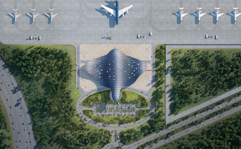
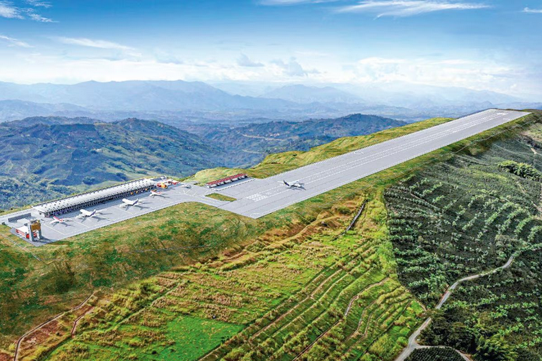

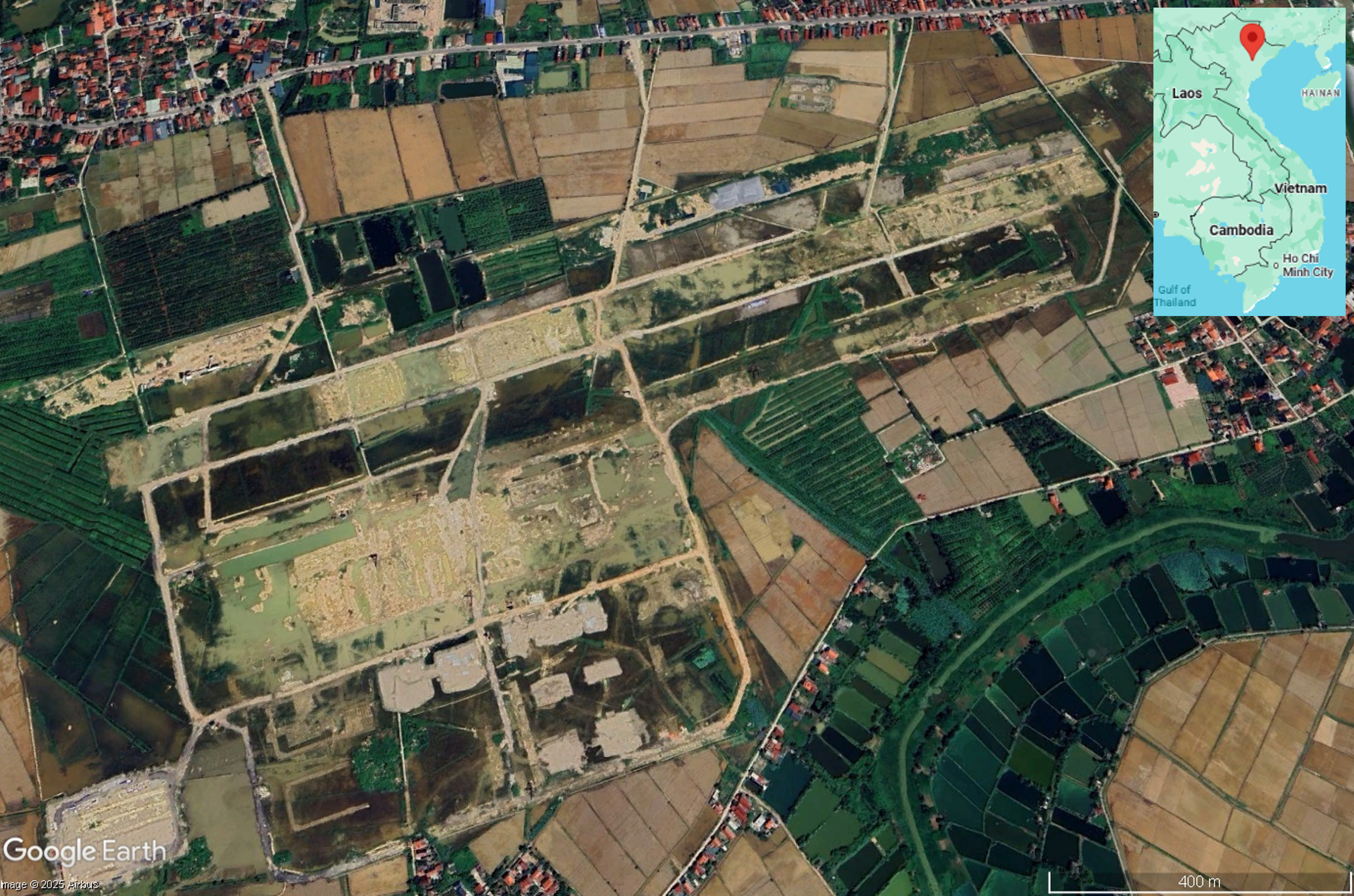
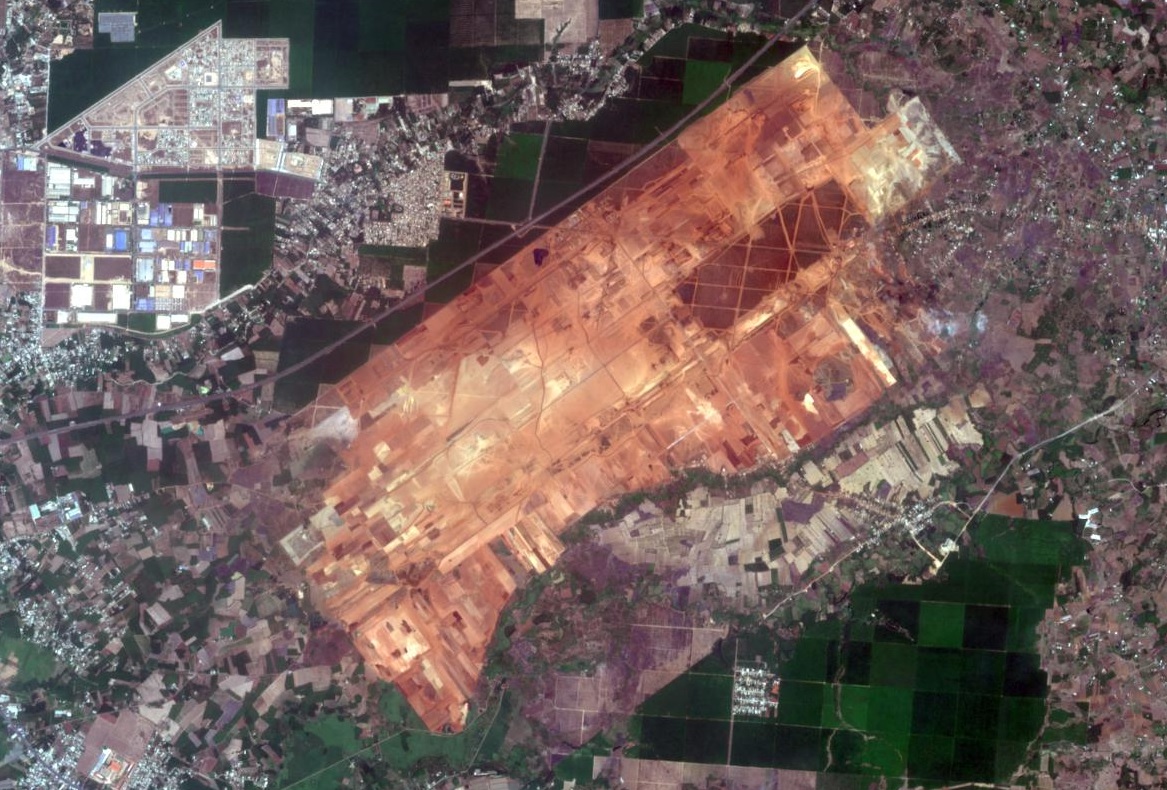


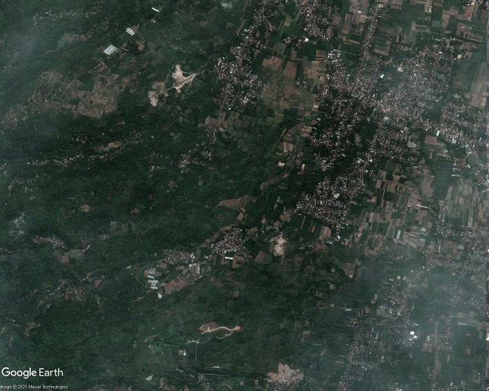

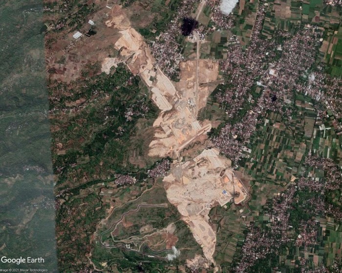
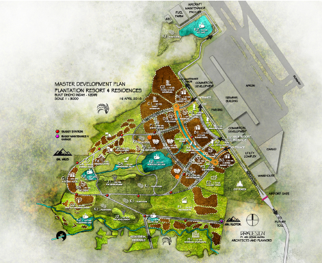
.jpg)


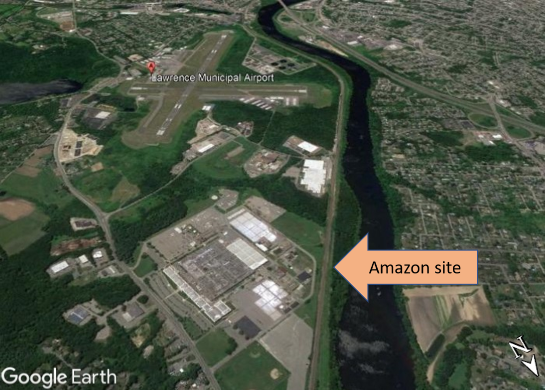


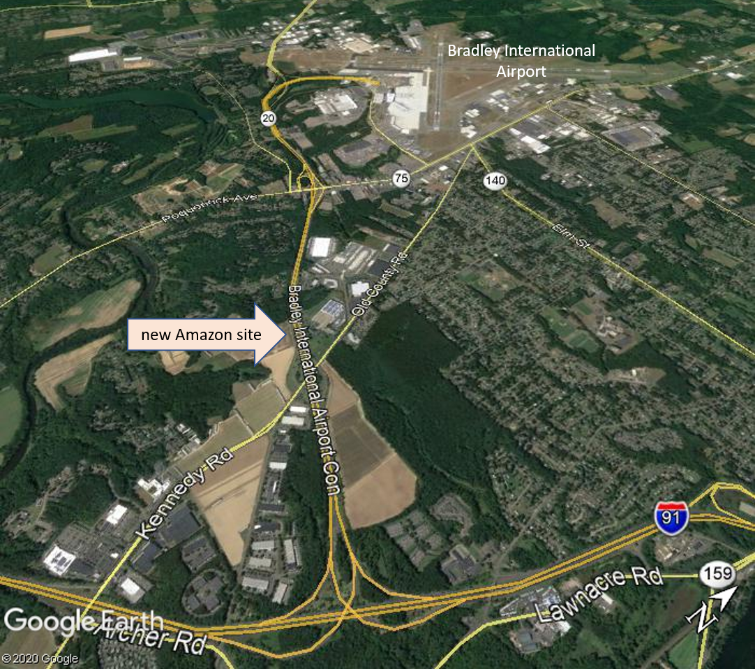


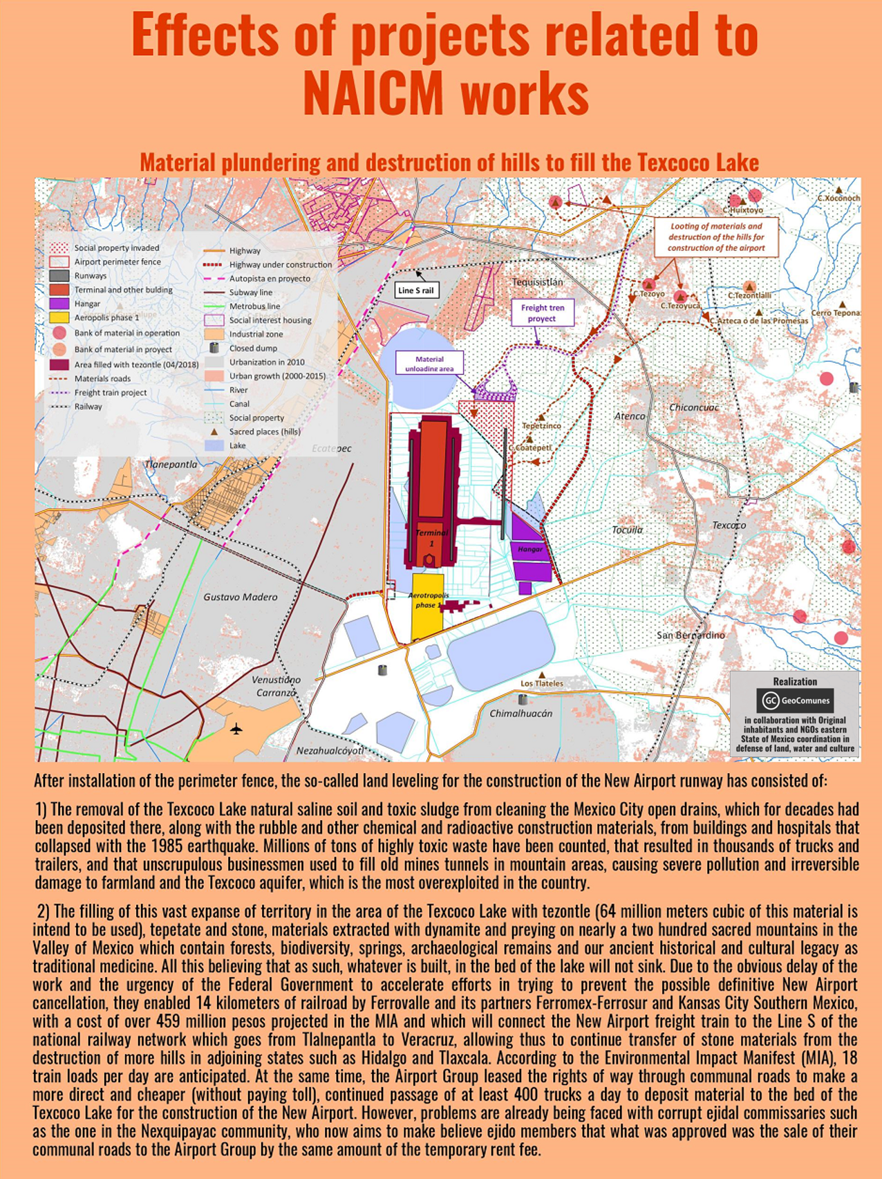


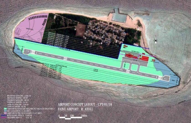
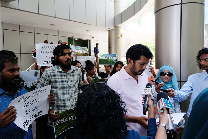
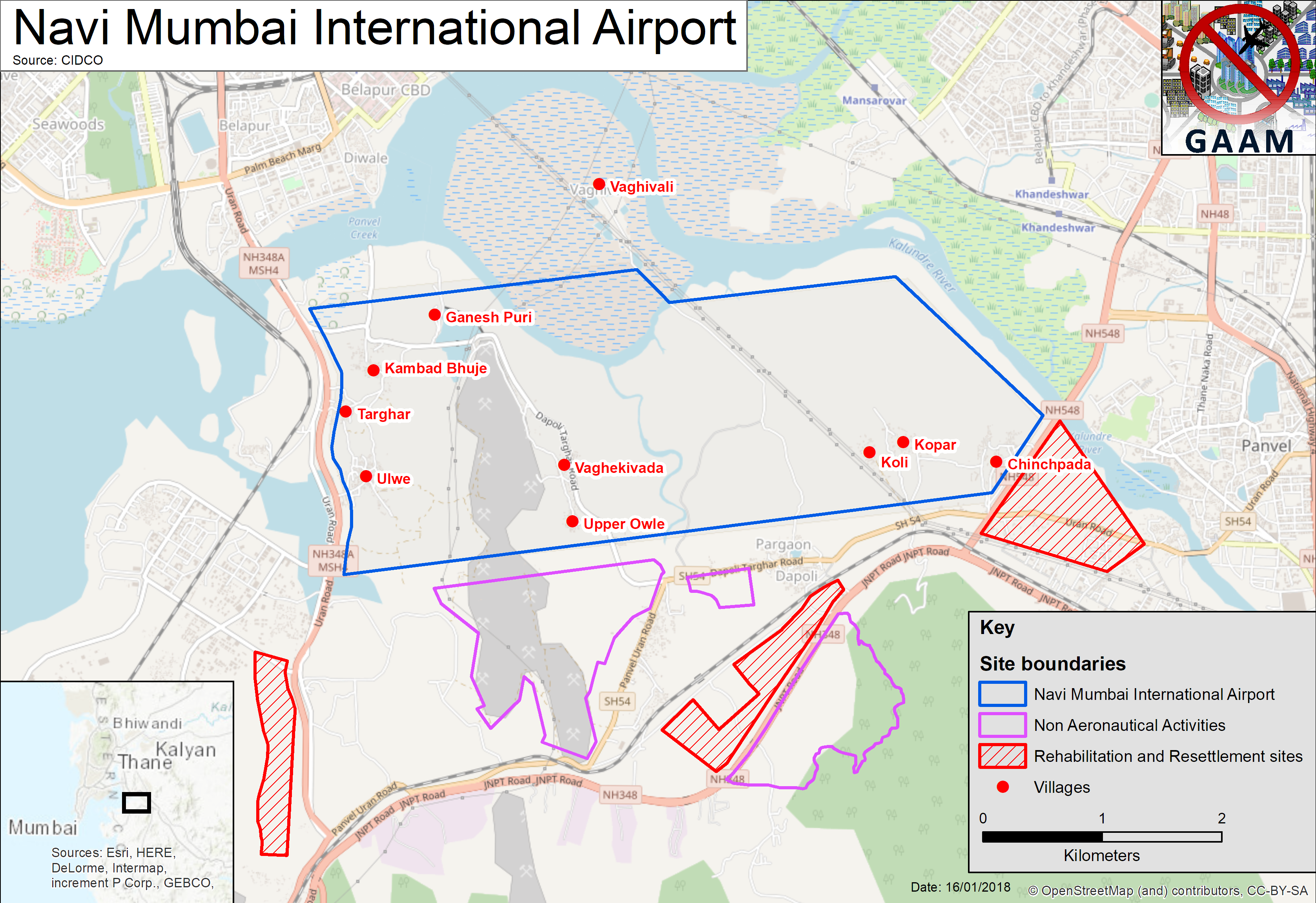 A mega-airport is planned, handling 10 million passengers annually upon completion of the first phase, rising to