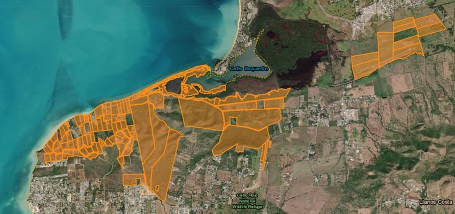
Many local and diaspora organisations are opposing Esencia, a luxury tourism and residential megaproject with a private airport, in Cabo Rojo. The development has been granted generous tax credits and would require vast volumes of water.
In May 2024 two real estate firms, Reuben Brothers and Three Rules Capital, filed a master plan for Esencia, a USD2billion development in Boquerón Bay, Cabo Rojo on the west coast of Puerto Rico. Anchored by international hotel operators Mandarin Oriental Hotel Group, Aman Group and Rosewood Hotels and Resorts and containing up to 500 luxury hotel rooms and 900 tourist residences the complex would have a private airport. The Esencia website says the new ‘residential and hospitality community’ will have 3 miles (4.8km) of ‘pristine beachfront’. Plans also included two golf courses, spa, wellnesses centre, health clubs, equestrian centre, hiking and biking trails and a school.
The proposed Esencia plan, with sea views and a private airport, includes luxury hotels and residences and two golf courses. Image source: Reuben Brothers
The Esencia project was granted more than USD497 million in tax credits and in August 2024 four new tax exemptions of between 90 and 100 per cent were approved. A new decree granting 100 per cent fuel tax exemption for tourism-related activities was criticised for incentivising high levels of fossil fuel usage. Comité por la Verdadera Esencia del Suroeste sent statements to multimedia platform Marea Ecologista concerning the proximity of the project site to protected ecologically sensitive areas providing habitats for endangered birds such as the Puerto Rican nightjar. Responding to the absence of public hearings on permits and boundary demarcation for the Esencia project a town hall was convened by local community, environmental and cultural groups on 28th September 2024 where further detail of Esencia project components, including shopping malls and renovation of an airstrip to accommodate small aircraft, was shared.
The land within the site is rural and falls under two classifications. One category is rural land protected because of its ecological importance as it is located between two nature reserves and serves as a corridor for many species and also for its recreational value. The second category is rural land where there is more flexibility regarding development and in recent years mechanisms to evade compliance with the land use plan have been deployed such as declaring projects to be strategic or of critical importance. The project area contains at least 24 archaeological sites from the colonial and pre-colonial eras, many of which have not yet been explored.
On the first day of public hearings in March 2025 Cabo Rojo’s streets were filled with protesters holding posters and banners, many declaring ‘No to Esencia’ and calling the project an enclave for a small number of billionaires. The hall was not big enough to accommodate all the people opposing the project so many watched the proceedings on a screen in a tent outside. Puerto Rican groups opposing the project joined forces under the slogans ‘Defend Cabo Rojo’ and ‘No to Esencia’. The anti-Esencia movement gained support from Puerto Rican diaspora and pro-independence organisations, amplifying locals’ calls for cancellation of the project and holding protests throughout New York. For example, protesters occupied the lobby of the Mandarin Oriental Hotel and unfurled banners in the luxurious Columbus Circle shopping mall.
Officials said the project’s environmental impact statement (EIS) did not address the impacts on infrastructure and ecosystems and lacked hydrological studies. Esencia would place additional strain on water supplies, consuming more than 1.25 million gallons per day, a volume equal to more than a third of current consumption in the Cabo Rojo Municipality. This is a low estimate as it does not include the project proposal’s two golf courses which would increase the volume of water consumed per day to 2 million gallons. The development would require extraction from aquifers or connection to the existing drinking water system but neither of these options are feasible. Local fishers expressed concerns over the risk of damage to oyster beds and disruption of freshwater and saltwater flows that are essential to the health of the estuarine environment.
Many of the properties purchased for the Esencia project are shown in orange, agricultural land purchased in August 2025 is shown to the right. El Nuevo Día, 20/09/2025
By September 2025 project investors had spent approximately USD147 million on properties for Esencia and were on track to acquire the target of 809 hectares of land. Recent land parcel purchases were part of the Reserva Agrícola del Valle de Lajas (Lajas Valley Agricultural Reserve) and an airstrip. On 12th September the Department of Natural and Environmental Resources (DNRA) published a 29-page report firmly reiterating its opposition to the Esencia project and concluding that the plans did not comply with environmental laws. Significant findings included fragmentation of habitats hosting endangered bird species, severe impacts on Catesbaea melanocarpa, a rare, endangered lily and threats to the habitat of Anolis poncensis, a rare lizard species. The project’s so-called ‘ecological corridors’ lacked the connectivity of existing ecosystems and golf courses, artificial ponds and landscaping claimed to be mitigations would be part of the project’s negative impacts.
For more information including references for all source material and photos see the case study on EJAtlas, the world’s largest, most comprehensive online database of social conflict around environmental issues – Esencia project, Puerto Rico
Construction of the Great Transfiguration Project – a mega tourism development n the St. Catherine areacomprising luxury hotels, villas, chalets, visitors centre, shopping bazaars, housing and roads –is linked to expansion of St. Catherine Airport.
Great Transfiguration Project (GTP) area, Egypt. Aerial imagery: 2nd July 2023
The Great Transfiguration Project (GTP), a mega tourism development project including hotels, villas, chalets, private housing, shopping bazaars, other facilities and roads in and around the St. Catherine area – a designated UNESCO World Heritage Site which includes St. Catherine’s Monastery and Mount Sinai – was announced by the Egyptian government in March 2021. Within weeks demolitions and construction works by private companies began. An August 2022 statement by the Egyptian Human Rights Forum (EHRF) detailed the project components, situation on the ground, impacts on and response from local communities and NGOs and comments from experts. Many contributors confirmed that GTP implementation had already caused serious, irreversible damage of nature, ecosystems, heritage and negative impacts on local people. EHRF’s statement said authorities had not included the local Jebeleya Bedouin tribe or the wider local community and that local organisations, community representatives, experts and representatives of St. Catherine’s Monastery (one of the oldest continuously inhabited monasteries in the world) and its inhabitants had not been consulted. A St. Catherine’s expert said homes were being demolished without compensation, part of the mosque had been demolished and the cemetery dug up. An eyewitness said many old olive and pistachio trees had been removed and some locals had worked together to replant them in different gardens. Construction of a 70km highway connecting St. Catherine with Al-Tur, on the Gulf of Suez, raised concerns over the environmental impacts. An expert on St. Catherine’s natural environment said, “This highway destroys an area designated by Egypt’s government as a nature protectorate, it cuts through the protected area and splits it in two, causing environmental ruin.”
In March 2022 a Middle East Eye correspondent gathered testimony from several local people concerned about the impacts of the GTP. One resident spoke of concern for the future of the heritage site, saying, “What is sold to us as development is in fact ruining this ancient and beautiful city.” A tourism worker, one of several people commenting on social media and posting photos of demolished buildings, said, “The view to most of the ancient sites of the city will be blockade by the concrete buildings now constructed in it”. One resident spoke of bulldozers tearing down important buildings, replacing them with blocks of concrete. Another resident said, “We wake up every day to discover that some buildings have been demolished and other made of cement constructed instead of them.” Mada Masr reported that two anonymous sources said the government began implementation of the project before submitting environmental impact assessments. A resident raised concerns over the project’s water consumption in a city reliant on wells and tanker trucks from Al-Tur saying, “Where will you get water for those employed in hotels, chalets and homes? They’re building swimming pools while people still wait for the water trucks once a week.” Accommodation built for relocation of residents, apartments in multi-storey buildings, some of which were already housing displaced residents, were very different from Bedouin’s traditional single-floor dwellings with gardens. One resident said, “These do not look like our homes nor do they align with our customs. We would not know how to live comfortably. But when they relocate us, we will have no other choice.”
Concluding a 10th March 2024 inspection tour in St. Catherine to assess the development projects Prime Minister Mostafa Madbouli said the GTP would be Egypt’s gift to the entire world. He said the state had made significant efforts to implement the project, beginning with development of St. Catherine International Airport, located 20km northeast of the city, into an international airport. A World Heritage Watch press release entitled ‘Mount Sinai: A Sacred Landscape Disfigured by a Megatourism Project’, issued on 18th December 2024 stated, “A new urban world is being built around a people of nomadic heritage,” It stated that the site surrounding St. Catherine’s monastery had been transformed. Landscapes had been damaged, the rights of indigenous people violated, houses demolished, important cultural sites destroyed and Bedouins had lost tribal territories. Heritage groups around the world had raised the alarm about the scale of commercial and infrastructure development in St. Catherine. Fourteen plots of land confiscated from the monastery by the Court of Appeals included agricultural land, gardens and buildings protected as antiquities including Saint Panteleimon Church on Mount Sinai which dates back to the 6th-7th centuries. In 2023, UNESCO had asked the Egyptian government to halt further development projects, evaluate the impacts and prepare a conservation plan for the area. The requests were ignored and construction of concrete buildings including luxury hotels, new roads and development of St. Catherine’s Airport into an international facility with a 3km runway, enlarged terminal and VIP lounge continued. Speaking to New Lines Magazine in June 2025 an anonymous resident said, “the fate of personal property that falls in the way of this construction remains unclear. Assurances and fake promises change day by day.” An anonymous expert said Jebeleya people’s homes were being demolished with no compensation. The aforementioned bulldozed cemetery had been paved over to create a parking lot. Plans for 700 new housing units caused worries that Bedouins might be displaced. An anonymous expert said, “Many fear they could be compensated with an apartment, which does not suit their way of life. They need outdoor space – for their livestock and to plant.”
For more information including references for all source material see the case study on EJAtlas, the world’s largest, most comprehensive online database of social conflict around environmental issues – Great Transfiguration Project, Egypt
A new international airport under construction in the Pedernales province in the southwest of the Dominican Republic, for commercial and private flights, is integral to development of a high-end coastal tourism complex.
Cabo Rojo International Airport construction site. Satellite image 09/09/2024
In January 2024 the government of the Dominican Republic announced construction of a new international airport in the Pedernales province in the southwest of the country. The site is in the Manuel Goya community, part of the Oviedo municipality. A Spanish firm, Acciona Construction SA, was awarded the contract to build Cabo Rojo International Airport, even though its bid was the most expensive. The RD$3,961 million (€62 million) contract, awarded in June 2024, included construction of a 3.1 kilometre runway, taxiway, aprons for Boeing 777 aircraft (the world’s largest twin-jet aircraft accommodating up to 368 passengers) and drainage works. The new airport will serve luxury tourism and private aircraft (private jets). Director of the Airport Department, Víctor Pichardo, highlighted the new airport’s potential to transform tourism in Pedernales by attracting both commercial flights and private aviation, noting that each year more than 40,000 private aircraft fly over the Carribean. He said the new airport would position the Dominican Republic as a hub for high-end tourism. Construction of the new Cabo Rojo Airport (also known as Pedernales Airport) is scheduled to be complete by the end of 2025; it is anticipated to handle up to 1 million passengers annually within 17 years, making it the third busiest airport in the country.
Artist rendering of development of planned luxury tourism development near the new Cabo Rojo International Airport and expansion of Port Cabo Rojo. Image: Dominican Today
The new Cabo Rojo International Airport, will form the basis for a new coastal tourism complex with 12,000 rooms located just 15 minutes away (about 25 km). The two locations are already connected by a major highway: DR Route 44. The tourism complex site is near the existing Cabo Rojo Domestic Airport, a civic/military airport currently receiving a few small aircraft, carrying 2-30 passengers, per week and serving operations of the Dominican Air Force. Tourists will also be delivered to new resorts via Port Cabo Rojo, which is expanding into a facility capable of receiving two large cruise ships carrying up to 15,000 visitors. Large volumes of fresh water will be diverted to the tourist area via a new aqueduct which will supply 8,000 tourism rooms. As of July 2024 the ProPedernales tourism development trust, a Public-Private Partnership (PPP) with the government holding a 52% stake and the private sector holding 48%, reported a total investment of USD130 million on Cabo Rojo tourism, focused on the first three hotels and the airport runway. In addition, the Dominican Government had spent nearly USD30 million on water projects, site conditioning, planning and design to prepare for and support the initiative.
Six major international hotel chains, ‘a who’s who of luxury and all-inclusive resorts’, are building new properties in Cabo Rojo: Hilton, Marriott International, therostar Group, Karisma Hotels & Resorts, Amresorts (part of World of Hyatt) and Sunwing. Luxury tourism development just 15 kilometres away from the border with Haiti, gripped by gang violence and a humanitarian crisis, might seem incongruous. But the Dominican Republic has reinforced the border with Haiti with more than 13,000 troops and the first phase of a high-tech ‘smart’ border wall with drone patrols, surveillance towers and night vision cameras is nearing completion. The exclusivity and high security requirements of luxury tourism can go hand in hand with militarisation; the established Cabo Rojo Airport nearby already serves the Dominican Air Force.
At a June 2025 National System of Protected Areas (SNAP) conference a number of environmental experts stressed the importance of responsible tourism development in Cabo Rojo, avoiding repeating the mistakes of some other Dominican tourist destinations by protecting the region’s ecology and directly benefitting local communities. But problems have been reported in the earliest stages of Cabo Rojo’s tourism development. In August 2024 environmental organisation Grupo Jaragua said the project was proceeding without clear compensation plans for affected residents of the Oviedo municipality, where the airport is being constructed. A community leader reported that tractors had destroyed land. Two months later a truck drivers’ union took strike action protesting non-payment for tranport of fill materials used for airport construction, saying the amount being paid per kilometre was not even sufficient to cover their fuel costs. The government is providing a high level of financial and infrastructural support to tourism and airport megaprojects that will primarily benefit airlines, major international hotel chains and cruise ship lines, not local businesses, and only wealthy visitors will be able to afford to stay in the luxury hotels. And the new high-end tourism complex may well boost the number of private aircraft flights, only affordable to a small number of very wealthy people, at Cabo Rojo Domestic Airport.
The second part of a two-part video, Aerotropolis: Evictions, Ecocide and Loss of Farmland, highlights damaging impacts of aerotropolis (airport city) projects on people and the environment. Evictions can be large scale and there are many instances of human rights violations. Allocation of large greenfield sites places farmland, forests, wetlands and coastal ecosystems at risk.
The video looks at 14 aerotropolis-type projects: Central Transport Port-CPK (Poland), Manchester Airport City (UK), Airport City Gatwick/Horley Business Park (UK), New Mexico City Airport (NAICM), (Mexico), Santa Lucia Airport (Mexico), Northwest Florida Beaches Airport (US), Vernamfield Aerotropolis (Jamaica), Hamilton Aerotropolis (Canada), Pickering Airport/Toronto East Aerotropolis (Canada), Mattala Airport (Sri Lanka), Nijgadh Airport (Nepal), Istanbul Airport (Turkey), Bulacan Aerotropolis (the Philippines) and Sanya Hongtangwan Airport (China). For further information see the comprehensive Reference list of all source material, including photos and other images. Part 1 of the video can be viewed here.
A plan for a major city extending over up to 600 square kilometres around a new airport in Navi Mumbai diverges from the aerotopolis model of development; the land area and number of villages included in the jurisdiction has reduced.
NAINA (Navi Mumbai Airport Influence Notified Area) originated when the Indian government granted clearance for a second Mumbai airport, in Navi Mumbai. One of the conditions for approval of the new airport was ‘that the Master Plan, Development Plan of Navi Mumbai shall be revised and recast in view of the Airport development and to avoid unplanned haphazard growth around the proposed airport’. Factors considered in assessment of the Influence Zone around the new airport included ‘the requirements of International Airport as per the aerotropolis concept’, connectivity and operation of various planning authorities in the region. Appointment of a ‘Planning Authority for a Planned and orderly development within a radial distance of about 25km from the proposed International Airport site’ was deemed necessary. On 10th January 2013 City and Industrial Development Corporation (CIDCO) was appointed as the Special Planning Authority.
Even at this stage it was evident that NAINA (the pink shaded areas on the map) diverged from the aerotropolis model of development. The designated NAINA area was fragmented and not even contiguous with the Navi Mumbai International Airport site (shown on the map as an orange rectangular area to the west of NAINA). The new jurisdiction, encompassing 270 villages in six talukas in the Raigad and Thane districts, a mix of peri-urban and rural areas, was not the recilinear greenfield site of an archetypal aerotropolis.
A large land area was designated for NAINA, estimated at between 550 and 600 square kilometres (1.5 times larger than the city of Mumbai). Inception of NAINA transferred planning powers to CIDCO; notification specified that all proposals for development permission would henceforth be processed by CIDCO. Land acquisition for the initial phase met with opposition. In 2014, while a survey was being undertaken, residents of the 23 villages notified for development in phase 1 of NAINA (to the east of the Navi Mumbai International Airport site) voiced strong objection saying they were not informed about the project which would adversely affect agriculture, their main source of income.
A spokesperson for the 23 villages said people did not trust CIDCO because farmers who lost their land in the 1970s, for development of Navi Mumbai city, had still not been compensated. Affected families had been promised employment but many were still doing odd jobs to make ends meet. Villagers also raised objections to CIDCO’s practice of providing information in English, a language most of them did not understand. A hearing was rocked by protest and villagers claimed that developers’ land was being treated preferentially, left untouched while theirs was earmarked for public utility purposes.
In an article published in Economic & Political Weekly ‘Fragmentary Planning and Spaced of Opportunity in Peri-urban Mumbai‘ Malini Krishnankutty describes how the Interim Development Plan (IDP) prepared for the first phase of NAINA, encompassing 23 villages, ‘reinforces the planners’ lack of deep engagement with the rural’. NAINA’s role of amassing land for implementation of its master plan exemplified modern urban planning’s disregard for rural areas. Such planning interventions viewed land merely as a resource, the rural as a ‘tabula rasa’ destined for urban development, villages from ‘the narrow perspective of providing very specific social amenities or transport infrastructure’, thus rural villagers and their ways of life were rendered invisible. With regard to NAINA she writes:
‘Once again what is visible here is a superimposition of a vision of a city on these villages, a view of urbanisation that is a foregone conclusion, and a lack of engagement with the future of the villagers, once they are divorced from their lands and livelihoods. There is also no engagement of planners with any idea of conservation, tangible or intangible or of productive farmlands’.
NAINA’s proximity to the Navi Mumbai International Airport site had given impetus to speculative interest in the area. The airport and several major road and rail projects in the pipeline – Mumbai Trans Harbour Link (MTHL), Delhi-Mumbai Insustrial Corridor (DMIC) and a road + rail corridor extending from Virar to Alibaug linking peri-urban regions in the Mumbai Metropolitan Region (MMR) – all require land acquisition by the government that ‘inevitably means dispossession and loss of livelihoods’. In addition these infrastructure projects activate the ‘highway urbanisation’ that is prevalent throught India and the global south. Announcement of new infrastructure triggers commodification of land, opening up rural areas for urban development.
During June, July and August 2015 journalist Rahul Batia travelled along the path of the Virar – Alibaug road and rail corridor running through NAINA, talking with people affected by land acquisition for the project. The route of the road, a transportation corridor 126 kilometres in length and 120 metres wide, stretches from the city of Virar to the north of Navi Mumbai, running southwards through NAINA then curving easwards to the coastal town of Alibaug. On the interim development plan the transportation corridor appeared as ‘a thick white strip snaking through residential areas, growth centres, forests, and urban villages’. Twelve kilometres of the road were within NAINA phase 1 and impacts upon the 23 villages within this area loomed.
NAINA map showing route of road through Nere and other villages. Source: cidco naina
The poorest locals were the most perturbed by the ‘corridor of uncertainty’, believing it would ‘hit them hardest’; some were convinced that they had been ‘singled out for some kind of punishment’. There were allegations that the route being marked out for the road curved to avoid homes and land owned by rich and influential residents. Adivasis at a hamlet in Nere, one of the affected villages, came across a mark painted into an approach road and thought it was connected with the new transport corridor. The sarpanch (head of village) of Nere knew little about the road except that people would be relocated to make way for it, and did not know where they would go to. He had not seen the map of NAINA. Pointing out a notice with a yellow diagonal stripe marked ‘CH 51554’ he said, “They came here, made markings, and left. Nobody told us anything.” Inhabitants of the 23 villages in the first phase of NAINA lived in uneasy uncertainty. NAINA officials were holding consultations but many affected residents complained of a ‘disconcerting lack of information available about exactly what shape NAINA will take’ and said that rates for people wanting to build on their land were ‘exhorbitant’.
Opposition to land-pooling scheme
Unrest over NAINA plans continued into in 2016. In February farmers of 111 villages opposing NAINA united to form a committee, Shektari Utkarsh Samiti, and marched from Khargar to Panvel. They voiced many demands for changes to NAINA policy, including that the amount of their land to be given to CIDCO under the land pooling scheme, whereby groups of land owners hand over their land to a government agency for development of infrastructure, with a proportion of the land being returned to the landowners, be decreased from 40 per cent to 30 per cent. In September representatives of 36 villages in the Panvel taluka (administrative district) immediately to the east of the Navi Mumbai International Airport site, said they did not want to be part of NAINA and wished to be excluded from the plans and instead be included in the Panvel municipality. Together these villages cover 69.6 square kilometres, a substantial proportion of the total NAINA area.
Rajendra Patil, a representative of one of the villages, Kolkhe, said that waiting for finalization of NAINA plans had stalled development in their villages, and that the development model was tilted in favour of big developers whilst working against the interests of local farmers. Anesh Dawale, a former head of Shivkar village, said of NAINA’s land pooling scheme: “It is just a garb to release farm lands held by villagers to the builder lobby”. In particular, local people were of the view that the minimum land pooling norm of 18 acres favoured construction magnates. Dawale also said that the curbing of village council powers under NAINA had a negative impact on civic services, a view shared by Panvel’s MLA (Member of Legislative Assembly), Prashant Thakur.
In December 2016 it was reported that 14 villages on the outskirts of Navi Mumbai and included in NAINA feared losing their land due to the project. Community representatives said that authorities were reserving plots of land without consulting local people and that inclusion in NAINA was blocking development in their villages, in contrast with surrounding areas that were flourishing. The 14 villages repeated demands first made in July 2015 to be merged with the civic body NMMC (Navi Mumbai Municipal Corporation) instead.
NAINA area reduced
NAINA was described as ‘potentially the biggest smart city in India‘ at approximately 600 square kilometres in November 2014 but by May 2016 CIDCO appeared to favour polycentric urbanisation, in the form of ‘30 smart cities‘, Special Economic Zones and growth centres. CIDCO officials estimated that, in its initial years of operation, the new airport would handle two to three million passengers, a fraction of the widely publicised projection of 20 million passengers per year in the first phase, rising to 90 million when expanded to full capacity. By July 2017 many parcels of land in the 1st phase of NAINA had not been acquired due to opposition from villagers. The state urban development department had approved development of the 23 villages three months previously but the development plan was still not publicly available.
Map of NAINA, reduced to 474 sq km, September 2017. Source: CIDCO
CIDCO’s Modified Draft Development Plan for NAINA, published in September 2017, anticipates an inflow of passengers from the new airport, but there is no mention of mulitiple millions of passengers annually. The plan does not include the aviation-dependent tourism or freight facilities that form the mainstay of an aerotropolis. The plan details a substantial reduction in NAINA’s footprint and a map shows further fragmentation of the designated areas. Several villages were transferred to other jurisdictions, becoming part of Maharashtra State Road Development Corporation Limited (MSRDC – a development plan for the area along the Mumbai-Pune Expressway), Matheran Eco-Sensitive zone (MESC) and Maharashtra Industrial Development Corporation (MIDC). Thus the number of villages incorporated in the NAINA plan decreased to 224 and the land area was reduced to 474 square kilometres.
The voluntary land-pooling scheme was causing delays, so, in April 2018, at the request of CIDCO, the state government moved to fast-track the NAINA project by way of invoking town planning scheme (TPS) provisions for compulsory participation of villagers residing in areas encompassed in the development plan. Participation in the project was made compulsory for the 23 villages in Phase 1 of NAINA. A draft plan for this 37 square kilometre pilot area was published, giving villagers just 30 days to make suggestions and objections, enabling CIDCO tosanction the scheme in three months. CIDCO also moved to expedite road building, using a fast-track TPS process, allowing a total of 21 months from announcement to execution.
Diverting water to NAINA
NAINA will take up water as well as land. CIDCO’s September 2017 Modified Draft Development Plan for NAINA calculates NAINA phase 1 water demands to be 8.33 MLD (millions of litres per day) in 2021, rising to 29.75 MLD by 2031 then reaching 45.07 MLD by 2041. New sources of water are anticipated to meet the increasing demands of NAINA and other CIDCO projects: the Balganga dam from which 150 MLD would be available for NAINA and Khopta Area (another CIDCO project) and the proposed Kondhane dam from which CIDCO expects to receive 250 MLD. The state transferred the Kondhane dam project from the water resources department to CIDCO in August 2017. The dam will draw water from the Ulhas river.
Shortage of water supplies is a perennial problem in many areas of Mumbai. In 2018 water scarcity was exacerbated by construction activity for Navi Mumbai Airport, which put pressure on water supplies impacting on surrounding communities, including those within NAINA. By May 2018 Panvel had been suffering a severe water crisis for three months. Every summer water scarcity forced residents to rely on water tankers. But in 2018 the situation was more serious. Many areas in Panvel were only receiving water on alternate days. Villages under NAINA were only getting water every three or four days. A resident of Khanda colony, Vishnu Gavali, filed a public interest litigation (PIL) requesting the court to direct civic authorities to resolve the issue. The PIL states that, under the constitution, all citizens have the right to food, water and a decent environment, and that CIDCO was failing in its duty to provide basic amenities. Gavali said “As airport work has started, a lot of water is being used for the construction activities but sadly, the locals have been neglected.” A resident of Roadpali said “Cidco has given permissions for so many upcoming projects in the city, I don’t understand how they would fulfill water needs of so many projects.”
In March 2019 residents of Panvel gathered near the CIDCO water tank premises in protest over poor and erratic water supplies, denying their fundamental rights to a basic amenity. Leader of the delegation, Apoorva Prabhu, said they had suffered water scarcity for six months and were requesting regular water supplies of least two hours daily. In September 2019, with many areas facing water shortages, CIDCO took measures to ensure that NAINA would not be affected by the water crisis. A detailed project report (DPR) on Kondhane dam, to help ensure adequate water for NAINA, was expected to be completed within a year and revive the project.
Objections to NAINA plans
On 28th June 2019 the Times of India reported that the urban development department would publish the final approved plans for NAINA and Maharashtra State Road Development Corporation Limited MSRDC after the monsoon season. Citizens demanded the government publish the report of the planning committee on the objections and suggestions made by the public in order for there to be transparency over whether or not these concerns raised were addressed or not. Pankaj Joshi, architect and executive director of the Urban Design Institute said “Objections were raised to the government proposing industries in green zones in the metropolitan regional plan. The entire green belt will become brown if it is approved.”
Map of NAINA September 2019, area shrunk to 371 sq km. Source: Times of India
By September 2019 NAINA, promoted as India’s largest planned city in 2014, had shrunk to just over half its original size. The plan for a new city, spread over up to 600 square kilometres of land, had shrunk substantially, now occupying a 371 square kilometre plot. The map indicated further fragmentation of the NAINA area and the number of villages incorporated in the plan had reduced from 270 to 175. The most recent government notification granted sanction for the development plan for the remaining 152 villages covering 334 square kilometres, along with the 23 villages included in the 37 square kilometres allocated for phase 1.
Unrest among farmers affected by land acquisition for NAINA was reported again in January 2020. A protest against CIDCO had already taken place and farmers were planning further agitation. Several local leaders were raising their voices against the scheme. By 17th March CIDCO was reportedly ‘going ahead aggressively’ with implementation of NAINA, in the face of unrest by impacted people. About 10,000 farmers from the 23 villages of the first phase of NAINA were planning a demonstration. The farmers alleged that the town planning scheme was not beneficial to them and demanded a review. Vaman Shelke of NAINA Prakalpbadhit Shetkari Utkarsh Committee (NPSUC) said they were given notice if carrying out any construction work on their land, leaving them with no option but to accept the scheme. “This is a participatory scheme and we cannot be forced to join” said Shelke, explaining that farmers were demanding return of 50 per cent of developed land under the land pooling scheme instead of 40 per cent, along with additional benefits for loss of their agricultural land.
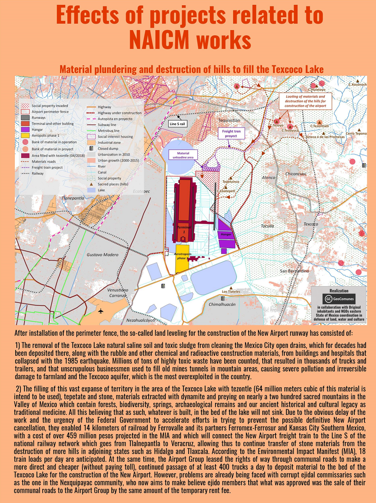
GAAM is delighted to share an incredibly informative set of maps elucidating the complex socio-economic and environmental impacts of construction of New Mexico City International Airport (NAICM). The maps were produced by GeoComunes, a collective working with communities to use maps as an analytical tool to strengthen the struggle for defence of common goods, in collaboration with affected residents and NGOs supported by Coordinadora de Pueblos y Organizaciones del Oriente del Estado de México (CPOOEM), which supports people’s defence of land, water and culture in eastern Mexico. The NAICM site, covering over 4,431 hectares, is the waterlogged Texcoco lakebed. Aerotropolis development is planned: a specific area within the airport site and commercial and industrial development over an extensive area surrounding it.
The first map, below, shows uncontrolled urbanization between 2000 and 2015, preceded by highway expansion, driven by real estate and encroaching on ejidos (communally held agricultural land) near the shores of Texcoco Lake. Landfill sites receiving waste from Mexico City have damaged farmland and polluted aquifers. The airport site is in the ‘Zona Federal’ area in the centre of the map. The existing Mexico City International Airport (officially named Benito Juárez International Airport) is shown near the bottom of the map.
A perimeter fence has been erected around the NAICM Phase 1 project area. The site includes ejidal lands, in spite of assurances that the airport would be built entirely on federally-owned land. Ejidal lands were also appropriated for a highway and housing developments, and many Ejidos (land holders) were violently evicted by state security forces. Plans for Aerotropolis phase 1 include a shopping mall, hotels, industrial park, exclusive high-end housing, golf courses and a free trade zone.
The third map shows satellite imagery of the three Ejido areas directly affected by airport construction. Over 330 hectares of ejidal lands, in the communities of Ixtapan, Nexquipayac and Atenco, were seized from its rightful owners by the government and now lie within the NAICM perimeter fence.
Land-levelling to prepare the site for construction of the airport involved clearing saline sludge from the lakebed and toxic waste that has been dumped, polluting the Texcoco aquifer and damaging farmland. Extraction of materials for use in has had a devastating impact on sacred mountains, in the Valley of Mexico. Blasting with dynamite has damaged, forests, biodiversity, springs and archaeological remains. It is estimated that 64 million tonnes of tezontle (red volcanic rock) along with stone and other materials, carried on 400 trucks per day, will be deposited to fill in the Texcoco lakebed.
Water drained from the Lake Texcoco area will be channelled into Nabo Carrillo, an artificial lake and newly created lagoons, along with water from the area east of the airport site channelled via several culverted rivers. Lying at the bottom of a downward slope the airport site is at risk of flooding from concentration of water flow in this area. The flood risk could become more severe as Texcoco lakebed is sinking at a rate of about 12 inches annually.
An extensive road network linking NAICM to key urban centres is planned and under construction, encroaching on ejidal land and opening up additional land for real estate and commercial development. Many of the roads are toll roads which will generate profits for construction firms holding the concessions and thus set to benefit from the traffic flow.
Data from all the maps is combined in the final map, which covers a wider geographical area revealing the extent of the urbanization that is underway and planned. See the larger version of the map for more detail. NAICM is shown within a wider context as the most important of, and the focal point for, a series of megaprojects combining to form a ‘Megalopolis’, an agglomeration of cities and other urban areas. New road and rail corridors will foster further real estate development. Mexico City already suffers chronic water shortages and springs and groundwater are over-exploited. The current model of urbanization will increase stress on water supplies and aqueducts are planned to access more distant sources.
All the maps of NAICM and aerotropolis plans can be seen here in their entirety and are best viewed on the largest computer screen that you can find so you can zoom in and see the intricate detail.
Residents of Sukamulya village in the regency of Majalengka, a predominantly rural administrative area in the West Java province, Indonesia, are resisting eviction for Kertajati Airport. They are fighting for their land and water, blocking officials from entering the village to measure land in order to acquire it for the airport. The stand-off between officials and villagers refusing to be displaced, which began on 8th August, is the latest chapter in twelve years of resistance. A plan for a major airport, taking up a land area of approximately 50 square kilometres, first surfaced in 2004.
The Front Perjuangan Rakyat Sukamulya (FPRS), which translates as the Sukamulya People’s Struggle Front, was formed to resist eviction for the airport and the campaign is supported by Indonesian land rights and agrarian reform NGO Konsorsium Pembaruan Agraria (KPA). As shown in a video by FPRS, hundreds of people are participating in the protests and women are playing a leading role. Sukamulya is bedecked with flags and banners. Road entrances to the village are being monitored day and night and blocked with tyres, preventing officials accessing land in order to measure it for the airport. A protest camp with a communal kitchen, using food harvested in Sukamulya and donated by villagers, helps maintain high spirits.
At the time of writing the blockade has been successful and the latest in several attempts at land measurement have been cancelled. Hundreds of residents blocked entry to the village, succeeded in holding back officials from the land agency, Badan Pertanahan Nasional (BPN) and police. On 1st September, hundreds of Sukamulya residents stated that they were ready to die in order to defend their land and demanded that the government treat them humanely. The action has garnered support from students and Majalengka farmers’ organization. Affected villagers are determined to avoid the fate of people whose land has been acquired for the airport; the level of compensation offered was insufficient for them to afford to buy land and build a house in nearby villages. But the government remains determined to impose the airport project. On 5th September, KPA reported that BPN was preparing to make another attempt to enter Sukamulya village to undertake land measurement, and that officials would be accompanied by a greater number of security officials.
12 years of resisting eviction for the airport
Over the twelve years since announcement of the Kertajati airport project there have been a great many protests. On 8th June 2007 hundreds of demonstrators rallied to protest against the threat of eviction facing at least 16,000 people from five villages. Speeches were followed by a mock trial of the Majalengka Regent, the head of the Regency. Demonstrators objected to lack of information about the airport project, including how much compensation they would receive from the government, and refused to be relocated.
Some residents have accepted compensation for their land and moved away, but the majority refuse to give land for the airport without fair land acquisition respecting their rights to accurate land measurement and appropriate compensation. Many reject the airport project entirely and are united in their refusal to give up their land for it. KPA maintains that the majority of the population of the 11 affected villages have opposed acquisition of their land and construction of the airport.
The FPRS video above documents a major protest on 25th January 2016. Hundreds of residents and their supporters rallied in front of the Majelengka land office and State Attorney office, arriving for the march in a procession of motorbikes and trucks carrying banners and posters. Rousing speeches voiced residents’ opposition to the construction of Kertajati Airport and the land acquisition process, protesting that it was not being conducted according to regulations. Villagers vowed that they would remain in Sukamulya. Hundreds of residents marched again on 22nd February 2016, demanding that delayed land compensation be paid to nearly 400 families and outraged that members of the community were being intimidated by officials. A video of the protest by the Majalengka police shows the presence of a large number of officials maintaining tight control of the demonstrators.
On 1st March 2016 the International Land Coalition (ILC) reported that conversion of the land for Kertajati Airport had resulted in the eviction of 10 villages. A tweet by ILC Asia showed a photograph of Iwan Nurdin, Secretary General of KPA, addressing a large group of evicted farmers from the affected villages.
On 2nd May 2016 hundreds of Sukamulya residents, supported by FPRS and KPA, rallied at the district government office demanding a fair land settlement. Speakers at the rally protested dishonesty in the land acquisition process including an inaccurate EIA (Environmental Impact Assessment) which stated that crop yields are far lower than are actually harvested. Intimidation by officials had forced some residents to flee from their homes and some had been detained.
Sukamulya villagers and their supporters defending homes and farmland from land acquisition for Kertajati Airport have good reason to be concerned that intimidation and harassment by officials may escalate into violence. There have been many clashes between security officials and people protesting against the airport and blocking access to land. A serious incidence of state brutality occurred on 18th November 2014. Without warning, hundreds of officials, surveyors escorted by armed police, arrived to measure land in the villages of Sukamulya and Sukakerta. Hundreds of residents attempted to block officials from entering the village area. Police responded with violence, firing tear gas and rubber bullets. Many citizens were injured from being trampled on and dragged away and some were beaten. At least five people were detained. A video shows a few minutes of the clash between authorities and villagers. Residents, distressed and angry, attempt to block officials from entering their village to conduct land measurement for the airport. Police and army officers herd people away from the village and confine them behind a fence. Many people are handled roughly by officials, pushed and shoved, and several are dragged along the road.
A mega-airport and an ‘Aerocity’
The developer of Kertajati Airport is PT. Bandarudara Internasional Jawa Barat (BIJB), referred to in English as West Java Airport and Aerocity Development Company. The planned airport land area, 1,800 hectares, far exceeds that which would be required should the airport meet its ambitious traffic projections of between 8 and 10 million passengers per year in the first phase of development, rising to 40 million passengers per year by 2035. It is larger land area than the world’s busiest airport, Atlanta in the US. In comparison, Atlanta Airport has a smaller 1,518 hectare site which includes a considerable amount of commercial development such as retail and warehouses. Yet Atlanta Aiport handles two and a half times the number of passengers planned for Kertajati Airport, just over 101 million in 2015. It is clear that land is being acquired for non-aviation purposes in addition to the area required for airport operations.
The proposed size of the airport creeps upwards. According to a BIJB video, by the beginning of August 2,500 metres of the planned 3,500 metre runway had been developed. But on 16th August the West Java province revealed plans to lengthen the runway even further, to 4,000 metres. The pale grey rectangle near the centre of the airport site is a completed section of the airport apron. The airport terminal is under construction adjoining the southern edge of the apron, and some of the farmland around it that is being destroyed, is shown in a tweet by BIJB:
Kertajti Airport is envisaged as the first phase of a larger ‘aerotropolis’ project, an airport surrounded by aviation dependent commercial and industrial development that is deigned to maximize use of air services. The full aerotropolis plan, with Kertajati Airport covering 1,800 hectares plus the proposed Kertajati Aerocity adjoining the airport site taking up 3,200 hectares, matches the 5,000 hectare project that was first mooted in 2004.
The Aerotropolis plan – a 50 sq km megaproject
A GAAM map shows the proposed boundary of Kertajati Aerotropolis that was indicated in a November 2015 presentation by a representative of BIJB entitled ‘KERTAJATI INTERNATIONAL AIRPORT & AEROCITY: INTRODUCTION & OPPORTUNITIES‘ at the Indonesia-Australia Business Week 2015. This event, aiming to develop closer investment and bilateral trade ties, was Australia’s largest ever business delegation to visit Indonesia. GAAM’s map superimposes the project boundary indicated in this document onto a 10th August 2016 satellite image of the aerotropolis site.
The map shows the area earmarked for the aerotropolis consists of farmland divided into strips and squares, villages and wooded areas. The rectangular area is the proposed site for Kertajati Airport. Adjoining the airport area is the Aerocity area, its southern boundary following the path of a river. In the BIJB presentation the claimed area of the Aerocity is larger than the 3,200 hectares stated by the project and government bodies, at 3,480 hectares. It could be significant that the land area indicated by the map in the BIJB presentation is even larger than stated in the text: 2,665 hectares for Kertajati Airport and 3,583 hectares for Kertajati Aerocity.
The first runway can be seen along the northeastern edge of the airport site. A second runway, parallel to the first and near the other edge of the airport site, is planned. Satellite imagery shows that earthworks have already prepared an area of land adjacent to the first runway for construction. The southernmost point of this area corresponds with the access road shown in the BIJB presentation. The footprint of the airport, and obliteration of farmland, threatens to extend beyond the site boundary with construction of access roads to the north and south of the airport area. A major road already runs through the planned aerotropolis site; the Cikampek-Palimanan Toll Road, part of the 653 kilometre Trans-Java Toll Road, runs through the Aerocity area, inside the southern boundary.
The Aerocity plan described in the BIJB presentation consists of typical aerotropolis components. Space would be allocated for hotels, retail, conference and exhibition centres, entertainment complexes, business park, offices, industrial and warehousing area, logistics and distribution facilities, aviation ancillary industries including MRO (Maintenance, Repair and Overhaul – of aircraft) and in-flight catering, plus a facility for Hajj and Umrah pilgrims. An ‘attractive incentives plan’, meaning subsidies for investors, is promised.
As a greenfield airport, and an aerotropolis, BIJB is not being constructed to serve established urban development, but to spur commercial and industrial development on the farmland surrounding the airport. Plans have been outlined for Kertajati Airport to become a ‘gateway’ to West Java; the airport and Aerocity would be an economic centre for the region, with direct access to the established Karawang industrial zone. Kertajati Airport is just one of 84 large scale infrastructure projects planned in West Java, including power plants, ports and roads, criticized by environmental forum WALHI West Java for the loss of farmland and triggering social conflict. Dianto Bachradi, Vice Chair of Komnas HAM (the Indonesian Commission for Human Rights), highlighted the private sector interests served by megaprojects. Specifically regarding airports he pointed out that employment opportunities for local people facing the loss of their livelihood from agriculture would be restricted to poor quality jobs such as baggage handler or parking attendant, and that the projects benefit large companies, not the local community.
As Sukamulya holds out against eviction recent announcements reveal more about the strategic significance of the aerotropolis to government and corporate interests. There is a military component as Indonesia’s state owned aerospace manufacturer, PT Dirgantara Indonesia (PTDI), a firm servicing both civilian and military aircraft, intends to relocate from its current location in Bandung to a larger 300 hectare site on the land surrounding Kertajati Airport, anticipating that the new facility will be operational by 2019. And the aerotropolis scheme has spawned a plan for yet another megaproject; a power plant. This 190 hectare energy complex is planned for the aerotropolis to meet its own energy requirements, as the electricity supply currently under construction will only be sufficient to supply the airport, not the Aerocity.
Allocation of government funds for construction
Land acquisition, displacement of villagers, destruction of farmland, construction of the runway, taxiway and apron and earthworks to prepare land for construction of the terminal and access road have proceeded in the absence of confirmed financing to actually build the airport. Repeatedly, the government announced offers and interest from investors, from China, Korea and Turkey and from airport operator/developers including GMR Infrastructure (based in India) and Schiphol Group. In December 2015 President Director of BIJB, Virda Dimas Ekaputra, stated that no less than 40 domestic and foreign investors, from Switzerland, Turkey, Germany, Qatar and India, had expressed interest in development of ground infrastructure, such as the terminal.
As yet, foreign investment has failed to materialize, and there has been a series of announcements on financing of construction costs, all of which will fall on the government. On 18th January 2016 it was announced that construction of Kertajati Airport will cost about US$267.4 million, to be paid by central government through the transport ministry. Indonesian President Joko Widodo announced this financing decision during a visit to Majalengka. It was also stated that the West Java government is to pay for clearing 1,800 hectares of land. The government had withdrawn its search for an investment partner for development of the airport, redirecting potential investors to the proposed Aerocity adjoining it.
On 16th August it was announced that an as yet unspecified amount of provincial government allocated to the project had increased, the project having already spent most of the US$38 million in provincial finds already contributed. The most recent announcement of state financing is that the first phase of airport construction will be funded by mutual funds including the social security agency for labour. The financing scheme would be underwritten by state owned financial services firm Danareksa. Whilst this funding scheme would spare the government from spending the state budget on construction of Kertajati Airport the state would be liable for the debt incurred.
Farmland bulldozed and concreted over
BIJB videos show the progress of Kertajati Airport construction. A video dated 4th February 2016 begins with footage of the airport toll road, already a long ribbon of smooth tarmac. Next there is a shot of road grading for the access road. Bulldozers are shown in a puddled field of mud next to all that remains of a community that has been systematically erased, a tiny cluster of dwellings, and a single tree.
The camera pans away to show construction in the midst of a patchwork of green fields and bare earth where vegetation has been stripped away. At this stage, concrete has been laid for 2,500 metres of the runway. A bulldozer gouges at the earth, preparing a level surface for the airport apron, a gigantic rectangle of concrete. The tranquil soundtrack is at odds with what must be a roar of earth moving trucks, bulldozers and heavy machinery.
The BIJB video shows development of the taxiway, with drainage channels running parallel. It is evident that the hydrological conditions of the airport site, low level land with a high water table, makes construction difficult. Adjacent to the apron, foundations for the terminal are being laid, and drainage channels dug into the flooded surface. Piles, long concrete posts, here called ‘pickets’, are being inserted deep into the ground. A total of 2,413 of these pickets are being driven down through weak layers of loose ground to reach rock or compacted soil that is strong enough to support the weight of the terminal building.
Water and food security concerns
A waterlogged site makes airport construction problematic, and drainage management will be challenging once the airport is operational, but airport operations require large volumes of water. There is a reservoir within the land that has been expropriated for the airport, the pale rectangular area near the southeastern corner. In June 2016, BIJB stated its intention to source its water requirements, initially about 30 litres per second but possibly rising to 60 litres per second, from within Majalengka.
Water may be plentiful in the area earmarked for Kertajati Aerotropolis, but it is a limited and precious resource. In Indonesia, the bigger picture is of water scarcity concerns, in particular on the densely populated island of Java. Diversion of water supplies from agriculture to industrialization impacts on irrigation of crops and therefore on food security. Kertajati Aerotropolis also poses a direct threat to food security due to loss of farmland to urban development. In May 2016 concerns were raised over food security implications of development on Majalengka farmland, in particular the prospect of the loss of 5,000 hectares for Kertajati Airport and Aerocity. Urban development on Majalengka wetlands could lead to a reduction in rice yields of 75,000 tonnes per year. Social and economic problems loom because of the loss of farmers’ livelihoods. In addition to rice many other crops are cultivated on the fertile Majalengka farmland, including beans, peppers, watermelons and mangoes.
A tweet posted on 19th July shows sheep grazing on green fields next to the terminal construction site, in the background is a skyline of piles and pile drivers pushing them into the soil. If Kertajati Aerotropolis progresses as planned this fertile farmland will soon be paved over.
Land conflict and Indonesia’s aviation expansion drive
Recent years have seen several airport-related land tensions and conflicts in Indonesia, in addition to the Kertajati case. About 300 kilometres to the southeast of the Kertajati Airport site, near the south coast of Central Java, Kulon Progo residents have struggled against loss of land and livelihood for a new Yogyakarta airport since 2011. Opposition to land clearance stalled construction of Kuala Namu Airport. It was expected to commence operations in 2009. In May 2013, as the airport prepared for opening, residents were still refusing the compensation on offer for eviction to make way for toll roads serving the airport. A week before the Kuala Namu opened, in July 2013, land disputes continued in five villages and more than 100 residents blockaded an arterial road.
A proposal for a second Bali airport, in the north of the island in the Buleleng Regency, was criticized due to pending displacement of agricultural communities and the sociocultural shock that would be inflicted on nearby villages, leading to an alternative plan for an offshore ‘floating’ airport. Yet the latest report on the new Bali airport plan still entails acquisition of populated land, stating that 656 hectares is required, predominantly residential land. The coastal villages of Pejarakan and Bumberkima would be affected and 3,335 people relocated, in order to offer wealthy tourists ‘panoramic views of white sandy beaches’. The elitist project aims to ‘cater to deep pocketed clients, servicing private jets’. Along with the airport investors intend to build aerotropolis-style development: hotels, restaurants and a yacht port.
In West Papua, dozens of families are refusing to be evicted for development of Manokwari Airport, and Sentani Airport finally agreed to pay compensation for acquisition of customary land in May 2016, after members of the four affected tribes blocked the taxiway with banana trees. In 2013 operations at Sorong Airport were disrupted by a rally demanding compensation for land.
Anti-airport movements in Indonesia are mindful of the long history of state brutality against people protesting confiscation of farmland for Lombok Airport. In the mid-1990s hundreds of families were evicted from 800 hectares of farmland for the airport. Oppression continued and in 23rd August 2005 a further 2,631 people were forcibly evicted for the airport. Then, on 18th September police, without provocation, fired into a crowd of 1,000 people who had gathered to commemorate Indonesia’s National Peasant’s Day and protest construction of Lombok Airport on fertile farmland. Thirty-three protesters were injured, 27 of them by gunshots, six from being beaten by police.
Kertajati aerotropolis is part of a wider Indonesian government drive for massive aviation growth. A target has been set to build 62 new airports over the next 15 years, in particular in isolated areas, which would bring the country’s total number of airports to 299. Inevitably, a number of these new airport projects will impact on rural communities and trigger resistance to displacement.
“The project of the NAICM will lead to water shortage” Vandana Shiva in Atenco
Desinformémonos
Mexico City. 14 August 2016. “At some point it will lead to a water shortage” said Vandana Shiva and Sebastiao Pinheiro during their visit to Atenco yesterday. With members of the Peoples Front in Defence of Land (FPDT) they toured the lands of Atenco that the government intends to dispossess in order to be part of the new airport in Mexico City (NAICM). They arrived early in the camp that is located in the area where they intend to build one of the access roads.
Vandana, winner of the alternative Nobel prize for the environment, asked Mexicans not to allow life to be exterminated and to come to support the movement of the FPDT and all those who oppose the construction of the airport in these lands.
Meanwhile, members of the FPDT told the environmentalists that in these lands they grow crops of pumpkins, olives, corn…