South Korea: Gadeok Airport environmental, viability, safety and relocation concerns, and Airport City plans

Construction of a major new airport on Gadeok Island, a government-driven project, is imminent despite concerns over economic viability, technical feasibility, safety, relocation of residents and environmental impacts. A proposed airport city complex would support airport operations and might be designated as a free economic zone.
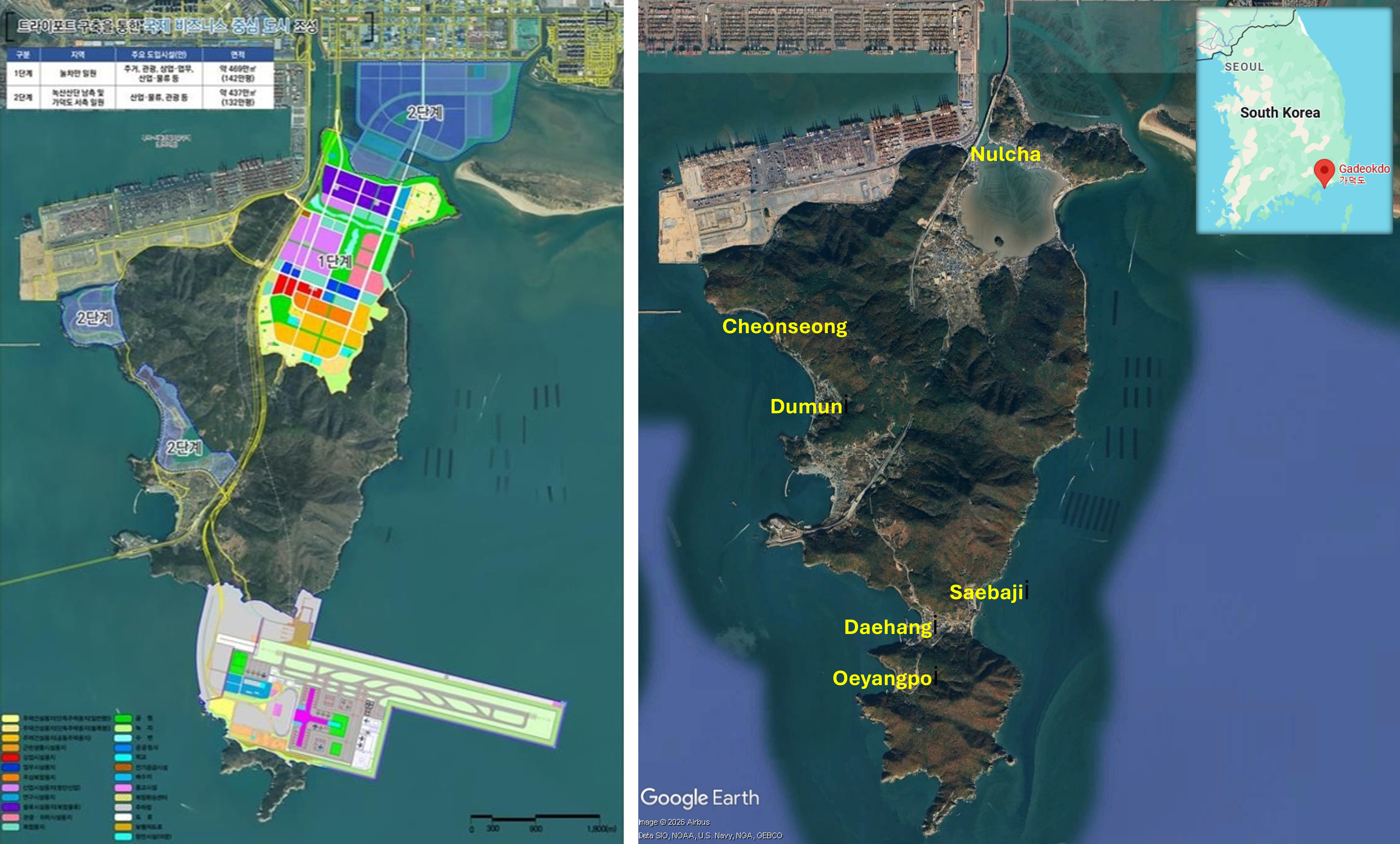
Gadeok Airport City, Free Economic Zone graphic
Left: Airport City Free Economic Zone development plan. Graphic: Busan Metropolitan City, Seoul Economic Daily. Right: Satellite imagery of Gadeok (Gadeokdo) Island dated 16/01/2026, showing areas impacted by Gadeok Airport and Airport City.

Gadeok Airport City plans

On 26th August 2026 the Busan City government released a draft designation plan and environmental impact assessment for Gadeok Airport City free economic zone, aligned with the master plan for Gadeok Airport. A graphic showed the new airport site on the south of Gadeok Island, with the runway extending eastwards into the sea, and the main Airport City sites to the north and on the west coast of the island. The city said public briefings on the Airport City would be held between the 7th and 23rd September and that, following deliberation and a decision by the Free Economic Zone Committee it aimed to finalise the development plan in 2027. If the Airport City is designated as a free economic zone, tax incentives and deregulation to attract international aviation and logistics firms are expected and there are plans for immediate commencement of compensation for land acquisition and construction. A comprehensive plan for the Gadeok airport city complex announced in August 2024 specified approximately 998 hectares of development on three areas: logistics facilities in Nucha, tourism and leisure facilities in Cheonseong and a renewable energy hub in Dumun. A ‘car-free, eco-friendly, pedestrian oriented city’ is promised with a large lake park and a pedestrian park running north-south and east-west. But these are just superficial features of an airport city development primarily designed to support airport operations.

A special bill, opposition and protest

Plans for a major new airport in South Korea’s southeastern region first emerged in 2006, only to be repeatedly shelved due to feasibility concerns. After a November 2020 state committee decision that a proposal to expand the existing Gimhae Airport (30 kilometres northeast of Gadeok Island) was unfeasible, for safety and environmental reasons and lack of local government representation in the process, bids to site a new airport on Gadeok Island and the city of Miryang came to the fore. The Democratic Party, (DP) having a large majority in the National Assembly, has been promoting the former. Then, in March 2021, the National Assembly passed a special bill supporting construction of a new airport on Gadeok Island. Passing of the bill allows construction of the airport to bypass several obstacles, including a normally compulsory preliminary feasibility study to determine viability before embarking on the project. A large majority voted in favour of the special bill, but opposition parties and some DP legislators criticised the government and DP for rushing the bill, passing it only three months after it was proposed. An assessment by the Ministry of Land, Infrastructure and Transport was sceptical about the project and residents and environmentalists expressed concerns over risks to endangered otters. On 30th June 2021, as DP leader Song Young-gil toured the proposed site, a gathering of local residents protested against construction of the airport.

A U$10.97 billion offshore airport

A detailed plan released on 26th April 2022 specified an airport solely for international flights, forecast to handle 23.36 million passengers and 286,000 tonnes of cargo per year by 2065. It would be the country’s first offshore airport, partially built on an artificial island on reclaimed land, requiring an enormous budget of KRW13.7 trillion (U$10.97 billion) and commencing operations in June 2035. Some regional lawmakers said the airport plan would require an even larger budget and longer time frame, adding to the ongoing doubts about the economic viability and concerns over the environmental impacts. Government plans for a free trade zone surrounding the site, intending to develop an international logistics hub, were already in the works. Three days after the release of the plan, on 29th April 2022, the Ministry of Economy and Finance said the government would forgo a feasibility study for the new airport and begin construction in the second half of 2025. Criticism of the airport project was increasing and a group of environmental activists held a protest demanding that the plan be scrapped.

Gadeokdo New Airport Construction Corporation was established on 25th April 2024 to oversee development of the airport. On 5th November 2024 members of a civil society organisation opposing the airport held a press conference in front of Busan city hall, calling on the government to cancel construction plans and denouncing the no-bid development contract that had been awarded to a consortium led jointly by Daewoo E&C and POSCO E&C. Yu Jeong-whon, professor of transportation systems engineering at Ajou University, argued in an article published by Korea JoongAng Daily that Gadeok Airport was being driven by politics, not policy, with passing of the special law supporting the airport, dismissing economic viability and technical feasibility concerns, eroding trust in the government. The cost could rise and the construction period increase to nine years. Despite the huge project cost and significance there had been very little deliberation involving citizens. Building the airport on soft marine sediment would necessitate massive ground reinforcement. The bird strike risk would be high due to the site’s proximity to the Nakdong River estuary, northeast of Gadeok Island, which is a major bird migration route. Fog and high wind speeds could also compromise flight safety.

 On 5th July 2025, two days after a snap election brought in a new DP administration, the Busan government stepped up the drive to develop the new airport, announcing commencement of negotiations on compensation for land and properties within the proposed site and aiming to transfer ownership to the government by the end of the year. Kim Byeong-kwon, director of Busan’s airport planning division, said, “The total number of items for compensation, including land and structures, is over 1,000.” The site contained 68 land parcels covering 37 hectares and the relocating process would affect 378 households. Busan city and the DP announced an extension of the construction timescale from six years to seven years.

Relocation anxieties

The following month Gadeok residents spoke of their anxieties over looming displacement for the airport. A total of 672 residents of three villages – Daehang, Saebaji and Oehaengpo (Oeyangpo) – were facing displacement. A 77 year old woman who had settled in Gadeok in the 1970s and run a small supermarket for 40 years was tearful and having difficulties sleeping due to rapid progress of the airport project and uncertainty over where to relocate to. Banners in Daehang village displayed slogans criticising the airport project and demanding relocation measures. Residents were anxious about the lack of clear answers from the Gadeokdo New Airport Construction Corporation which is in charge of relocation and that they might only receive compensation money rather than land or dwellings. The head of the Daehang Fishing Village Association said that in two years of meetings with the corporation relocation measures had not been mentioned. Dissatisfaction with compensation for land taken for development project is common and in Gadeok these concerns were intensified by claims that land prices had not risen in the 20 years of proposals and plans for the airport. On 3rd July 2025 residents holding a rally in front of Daehang breakwater demanded relocation measures and protested the compensation offer. A representative of the Daehang compensation committee demanded formalisation of relocation measures, including support for livelihoods, that had been omitted from the plan.

Lawsuit calls for cancellation

By September 2025 a lawsuit calling for cancellation of the airport master plan, filed by about 1,000 members of Action Against the Promotion of the Gadeokdo New Airport, was heading towards it fourth reading. The lawsuit stated that the site was unsuitable for an airport, having received a less favourable evaluation than alternatives in Gimhae and Miryang, and Gadeok’s natural environment and cultural value should be preserved. Attention to the opposition to Gadeok Airport had been heightened by the 11th 2025 September Seoul Administrative Court ruling cancelling the Saemangeum International Airport project, based on inadequate review of environmental factors, most pertinently the risks to tidal flats and of bird strikes. While the estimate of the likely number of bird strikes was lower for Gadeok Airport than Saemangeum Airport it was higher than Incheon Airport or Gimpo Airport, and some thought that collisions with seabirds around Gadeok’s coastal site, larger and flying at higher altitudes, were a more serious threat to flight safety. Arguments that too many new airports – ten planned and under constriction – were being pursued came from within the aviation and construction industries.

Delay, cost dispute and cost escalation

In November 2025 the government extended the Gadeok Airoprt construction period again, from seven years to ten years and eight months; the completion date was pushed back from 2032 to 2035. Calls for evaluation of the project site risks continued. Land reclamation would be a gargantuan task as the soft layer of ground beneath the site is 50-metres thick and typhoons causing 12 metre high waves would pose risks during construction and operations. In comparison, Incheon Airport was constructed on a soft ground layer one quarter of the thickness and ocean waves are only a third of this height. The Ministry of Land, Infrastructure and Transport announced finalisation of the basic design for Gadeok Airport site development on 7th September 2026. The design, prepared by the Daewoo E&C led consortium, will be reviewed by the Central Construction Technology Deliberation Committee. If the basic design is approved construction of the priority section of the airport is due to start in November 2026 with works on the main project anticipated to begin during the first half of 2027. A further project cost escalation is possible. Daewoo E&C requested a KRW620 billion (US$463,860) total project cost increase, citing increasing costs of fuel and materials caused by conflict in the Middle East. Daewoo E&C is benefiting from the airport even before construction begins; the firm’s shares surged by 12% on the day the Gadeok Airport basic design was finalised and it submitted its documents, and by a further 9% on the following day.
Vietnam: Development of dual-use (civilian and military) airport on Tho Chu Island

Conversion of 270 hectares of forest land has been approved for construction of Tho Chi Airport, classified by the Ministry of National Defence as an ‘urgent public investment project’ with an estimated total investment of VND28.8 trillion (USD1.1 billion).

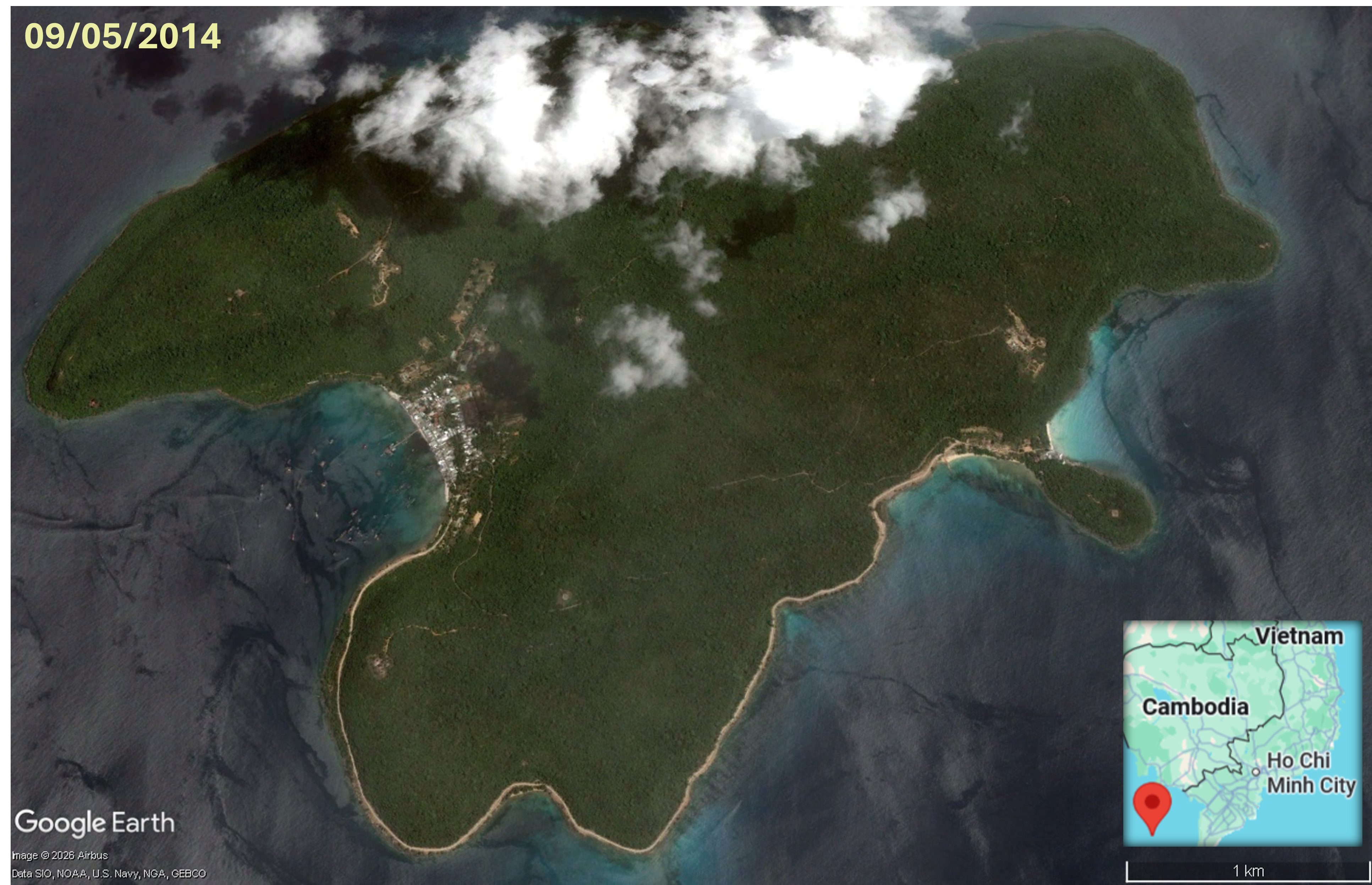
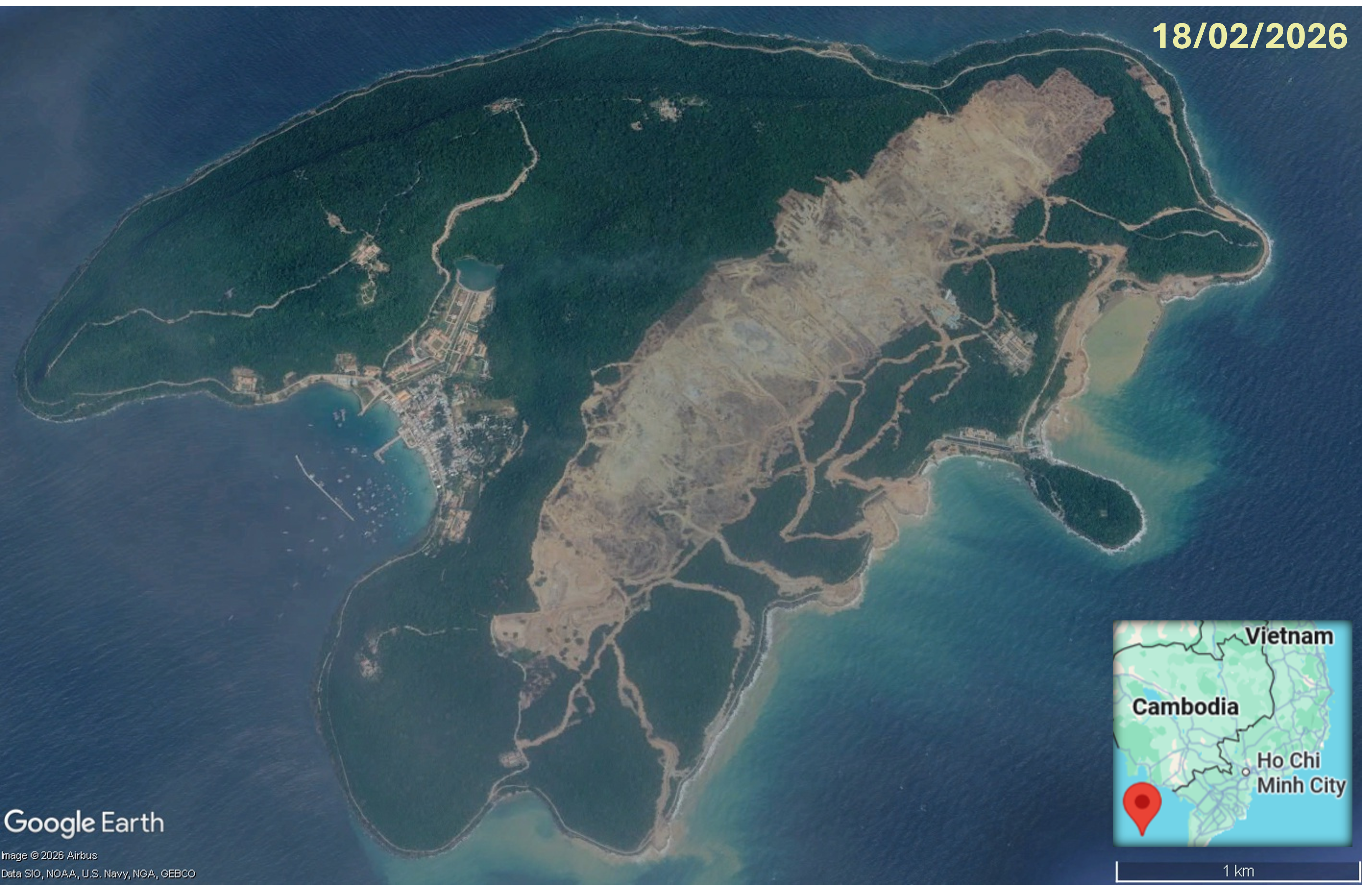
Tho Chu Island, aerial imagery 9th May 2014Tho Chu Island, aerial imagery 18th Feb 2026
Aerial imagery of Tho Chu Island.shows forest clearance, road network development and land reclamation that occurred between 9th May 2014 and 18th February 2026.

Geographically remote from the Vietnam mainland, and home to only 1,800 people, Tho Chu is located about 110km southwest of Phú Quốc Island in the Gulf of Thailand and is part of the An Giang province. Tho Chu is the largest and the administrative centre of eight islands comprising the Tho Chu Special Economic Zone and the archipelago is only accessible be sea. On a November 2025 visit, Party General Secretary and Secretary of the Central Military Commission, To Lam, called for transformation of the newly established zone into a ‘strong and sustainable maritime zone’, directing the Ministry of National Defence and other agencies to develop a master plan with feasibility studies for housing, upgrade of coastal road and other transport infrastructure, water and energy projects, and large seafood logistics and processing facilities. He spoke of the Tho Chu islands’ pristine ecosystems with clean seas, high-yielding fishing grounds, forest cover of 80-90%, sunny weather for seven months of the year and unique landscapes being ideally suited for ‘eco-tourism’. He also urged the Ministry of National Defence to consider construction of a dual-use (civilian and military) airport on Tho Chu Island, initially a 4C airport with capacity to handle narrow-bodied aircraft such as the Airbus A320 and A321 with potential future expansion to a 4E airport handling wide-bodied aircraft including the Airbus A350 and Boeing 787.

Plans for an airport on Tho Chu Island moved forward in December 2025 when Vietnam’s Ministry of Defence submitted a dossier for high-level review. The Tho Chu Airport master plan, for a dual-use airport, serving socio-economic development and transforming Tho Chu into a defence centre for the southwestern sea region, was added to the national airport network in May 2026. With an estimated total investment is VND28.8 trillion (USD1.1 billion) and land requirement of approximately 234 hectares the new airport is anticipated to reach capacity for approximately 20,000 passengers annually by 2030, rising to about 1 million passengers per year by 2050. The approved Tho Chu Airport plan is classified by the Ministry of National Defence as an ‘urgent public investment project’, exempt from investment policy approval and environmental impact assessment processes. The airport project aligns with the An Giang Province 2021-2030 development plan and on 21st May 2026 An Giang Province authorities approved conversion of 270 hectares of forest land for building Tho Chi Airport. The investor committed to pay for planting replacement forest. But newly planted forest is not a replacement for the biodiversity that builds up over time in long-established forest. And aerial imagery, in the timelapse graphic above, shows that, between April 2014 and February 2026, approximately 243 hectares of forest on Tho Chu Island was cleared. Grading works, levelling the site for construction, are underway, along with smaller scale forest clearance for coastal and access road development.

South Africa: Vaal Aerotropolis could take up more than 12,000 hectares of farmland

The Vaal Aerotropolis site encompasses a large area of farmland. Two runways, two terminals, an Airport City, solar farm and ‘vast agri-zones’ for air exports of agricultural produce and live animals are planned. Project partners view designation as, or inclusion within, a special economic zone (SEZ) as essential for attracting investors.

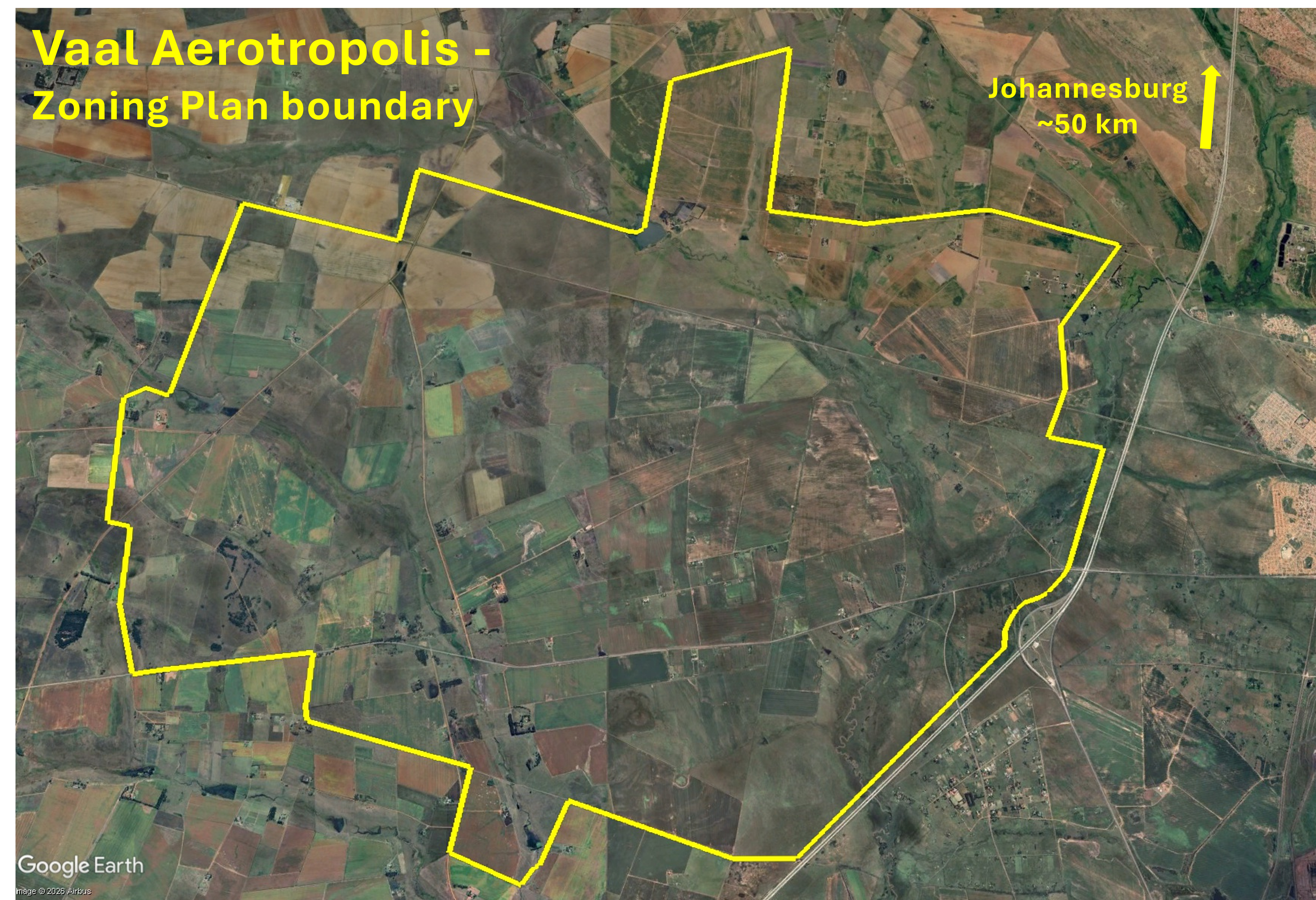
Vaal Aerotropolis - Zoning Plan boundary, 24th Jan 2026
The Vaal Aerotropolis site is predominantly farmland and adjacent to the N1 highway. This graphic overlays the Zoning Plan boundary of a 11,400 hectare site shown in the Vaal Aerotropolis Local Spatial Development Framework, page 35, onto aerial imagery dated 24/01/2026.

A multi-decade aerotropolis project

In April 2026, South Africa’s Department of Trade, Industry and Competition (dtic) announced public consultations, allowing comments and input from the local community, on designation of the Vaal Special Economic Zone (SEZ). Led by the Gauteng Growth and Development Agency (GGDA) the initiative includes a smart city and a new international airport, all to be supported by a ‘new “aerotropolis” – an industry term referring to an economic zone built around a major airport’. It was stated that the airport will be ‘supported by an extensive road network’ including direct access to the N1 highway, which is to the west of the site, so only a 50-minute journey from central Johannesburg. Nearly three years previously, in May 2023 Citibank South Africa, a subsidiary of US-based financial holding company Citigroup Inc., announced its investment in a ‘multi-decade aerotropolis project’ in the Vaal area, pledging R1.375 billion (USD84 million) having already applied for rezoning of the proposed development area into a special economic zone (SEZ). At an event held with dtic, Citibank SA’s Chief Country Officer Peter Taylor addressed the media, saying, “This is a massive infrastructure project. The timing of the airport itself will depend on a few things: the zoning, the licensing, the authority for the port etc. But a lot of work has gone into this. A lot of those [things] are being finalised. We are making an application for a an SEZ (special economic zone), which will encompass this area that the airport will be built in.”

Vaal AeroZone

Citibank SA is a major investor in Vaal AeroZone, the developer of Vaal Aerotropolis. Other partners in the Public Private Partnership (PPP) are the dtic, Gauteng Provincial Government, Sedibeng District Municipality, Emfuleni Local Municipality, PAPE Funds and Vaal Aerotropolis Design. The text at the top of the website home page reads like advertising for a particularly high-end VIP terminal: ‘VAAL AEROTROPOLIS: Pioneering a Sustainable Future for Travel and Innovation. Experience the future of luxury travel and innovation, where seamless connectivity meets sustainable opulence, shaping a world of refined possibilities.’ Yet in spite of the projected high passenger numbers, an initial capacity of 7.2 million per year (significantly higher than King Shaka Airport, the country’s third busiest airport handling just over 5.6 million passengers in 2025-26), the emphasis of the Vaal Airport project is on air cargo, ‘Vaal Aerotropolis will be the only airport in Gauteng where integrated air cargo services are designed and planned as a priority’, with initial capacity to handle 150,000 tonnes per year. Small blocks of text about development of a trade and logistics hub are packed with hype and superlatives: ‘VAAL AEROZONE: SHAPING THE FUTURE OF GLOBAL TRADE, Driving innovation, investment, and sustainable growth in the Sedibeng District’, ‘VAAL AEROTROPOLIS: A GATEWAY TO GLOBAL TRADE, Transforming the Sedibeng District into a world-class trade and logistics hub’. ‘A catalyst for economic transformation’. Green claims are prominent in the ‘AFRICA’S PREMIER GREEN AEROTROPOLIS’ and ‘CUTTING EDGE GREEN AIRPORT CITY’ sections. A timeline begins with inception of the project in 2020 and extends through to Phase 3 development commencing in 2068. A ‘GLIMPSE INTO THE FUTURE’ gallery consists of three computer generated graphics of generic airport buildings.

A video manifestation

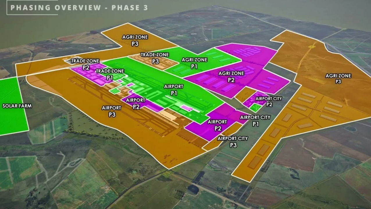
The AI generated voiceover of a promotional video, Vaal Aerotropolis: A Gateway to Global Trade. published on 18th November 2024, refers to the components of the project – Airport, Airport City, Agri Zone, Trade Zone and Solar Farm – as if they already exist or are inevitable; the word ‘will’ occurs eleven times. Graphics show development of Vaal Aerotropolis in three phases. The project, with two terminals, two runways, supported by the existing road and rail network along with future upgrades and interchanges, is called ‘a gateway to the continent’, ‘a lush aviation oasis’. A ‘great passenger experience’ is promised and ‘Vaal Airport City, one of the first purpose-built aviation cities in Africa’ sounds like a high-end development, with ‘fully serviced premium offices, retail, hospitality, medical and leisure spaces in an urban, minimum 4-star green rating’. But the envisaged facilities for passengers are dwarfed by plans for a 1,000-hectare solar farm and ‘vast agri-zones’ for ‘production of agricultural products amenable for transport by air.’ Enormous volumes of air exports of farm produce are anticipated, ‘This hi-tech agri-cluster is the largest climate controlled growing area on the continent, an integrated perishable supply chain’ (perishable air cargo is produce requiring a temperature-controlled cold-chain such as fruit, vegetables, meat, fish and flowers). Apparently, herds of livestock will be boarding flights, departing from ‘the first live animal holding area for transport by air in South Africa’.

Map of phases 1,2 and 3 of Vaal Aerotropolis
November 2024 map of phases 1, 2 and 3 of Vaal Aerotropolis. Graphic from video: Vaal Aerotropolis: A Gateway to Global Trade. Vaal AeroZone, 18/11/2024

Up to R200 billion investment, ‘pie in the sky insanity’

In December 2024, after delivering the Medium-Term Budget Policy Statement speech in which the grandiose Vaal Aerotropolis scheme was not even mentioned, Gauteng Member of the Executive Council (MEC) of Finance and Economic Development, Lebogang Maile, told SABC News, “We’ve got a new airport coming in Sedibeng which will see, I think, investment of anything between R20bn and R200bn from the private sector. In fact, it’s about R200bn, and we will be working with DTIC [Department of Trade, Industry and Competition] investing in bulk for that project”. This statement met with scepticism in a Moneyweb article ridiculing the project as ‘pie-in-the-sky insanity‘, deeming the maximum cost estimate of R200bn (USD 12 billion) ‘impossible’ when construction of King Shaka Airport in 2007-2009 had cost R6.8 billion, equivalent to R17 billion in 2024. The aim to handle 27 million passengers per year seems unrealistic; it is not clear who this vast capacity might serve with the entire population of Sedibeng amounting to just over 1 million people. The projected level of demand looks improbable as Gauteng has several underutilised airports. A notable example is Lanseria Airport, northwest of Johannesburg, which has capacity for about 4.5 million passenger per year, but was, at this juncture, only used by one commercial carrier, Flysafair, operating up to nine daily flights. The cost estimate for major expansion plans for OR Tambo Airport, including a a new passenger terminal and phase one of a new cargo terminal accommodating 650,000 tonnes of cargo per year, was estimated at R21 billion, a fraction of the possible R200 billion figure for Vaal Aerotropolis. And there is already a programme to establish another aerotropolis a mere 70km away, next to OR Tambo Airport in Ekurhuleni.

Infrastructural instability

Sedibeng’s crumbling infrastructure, leading to widespread failures in provision of basic services, casts further doubts on the feasibility of the vast, technologically advanced Vaal Aerotropolis. Major highways, including the N1 adjacent to the project site, are ‘decent’ but the wider road network is ageing. Potholes are ‘ubiquitous’. Waste management is poor leaving the landscape littered with ‘festering rubbish dumps’. The electricity supply is unstable. The situation is particularly serious iin Emfuleni, making provision of the requisite ‘infrastructural backbone’ for an aerotropolis seem like a ‘flight of fancy’. If it is constructed there is considerable risk of it becoming a ‘very large, very expensive white elephant’. The vision of handling 45 million passengers per year upon completion seems fantastical when compared to the 21 million handled by OR Tambo, South Africa’s largest and busiest airport. Community members attending a Vaal SEZ engagement held In Vereeniging town hall on 15th April 2026 raised concerns over Emfuleni’s dilapidated infrastructure, including unreliable water and electricity supplies, and how this undermines the credibility of a drive to attract investors to the municipality. The April 2026 cancellation of the licence for Vereeniging Airport, just 17 kilometres east of the Vaal Aerotropolis site, is further evidence of infrastructural collapse in the area. Maintenance of dilapidated fencing did not take place despite allocation of more than R100,000 (USD6,000) for the purpose, allowing uncontrolled access to the premises which placed the fuel farm at risk. Animals roamed freely on the site, sewage was leaking between buildings and the runway approach lights were stolen.

A ‘zone of comfort for investors’

The July 2025 Vaal Aerotropolis Local Spatial Development Framework (LSDF) report, was prepared by AeroZone for the Sedibeng and Emfuleni authorities to ‘allow them to plan and budget, in order to obtain approval and proceed with the project’. Great importance is attached to Vaal Aerotropolis being designated as a SEZ, or included in an existing SEZ, in order to benefit from a supportive planning framework, development rights, infrastructure provision and a range of incentives. Zoning is viewed as vital to attract investors, ‘It is important to entrench the zoning rights as early as possible in order to create a zone of comfort for investors. The LSDF will create this comfort.’ Most of the site is owned by Vaal Aerotropolis developer AeroZone, ~4,000 hectares directly and ~1,200 through lease of publicly owned land. A small area of the site is privately owned. The area encompassed by the Zoning Plan boundary is 11,400 hectares, but the eventual site could be even larger as the ‘total envisaged site area is approximately 12,125 ha in extent’. The majority of the site within the Zoning Plan consists of land that has been farmed since the early 1900s, it is ‘mostly cultivated fields with a few patches of open grassland vegetation’. Streams run through the site and there are small areas of trees, shrubs, and wetlands. The LSDF acknowledges that the ‘environmental attributes once provided by the commercial agricultural activities will be lost’. Potential exports of agricultural produce are estimated at 11,000-15,000 tons by 2032, 15,000-20,000 tons by 2037 and 25,000-30,000 tons by 2042. No numbers are given for live animal exports but it appears facilities for this could be substantial, ‘The Vaal Aerotropolis location is ideally suited to provide enough space for holding areas for various animals.’

The future of Vaal Aerotropolis is uncertain, depending upon extent to which the plans are realised, what materialises on the site and the level of utilisation. Whatever actually happens, the combination of the large site, road and rail network access, backing from several government bodies, substantial private investment and likely SEZ zoning make the Vaal Aerotropolis site a significant asset and a locus and instrument of power for project partners.

‘Mindfulness City’ megaproject begins with expansion of Gelephu Airport

Gelephu Airport, one of only four airports in Bhutan, is a domestic airport located in the southern Himalayan foothills, close to the Indian border. In August 2023, as formulation of the master plan for expansion of Gelephu Airport neared completion and groundwork preparations began, there was growing speculation among landowners with properties in the proposed site regarding replacement land and compensation. Acquisition of land was to be determined by the government. The groundbreaking ceremony for Gelephu International Airport took place on 23rd December 2023. Satelite imagery dated 1st January 2024 reveals a large area of low-lying scrub land has been cleared for the airport expansion.

Satellite imagery shows clearance of a large area of low-lying scrubland for expansion of Gelephu Airport, including the new runway, and construction of a dry port south of the existing runway.

Expansion of Gelephu Airport is a key component of an even larger megaproject, a new city, and some residents are concered about losing land to the project. On 15th December 2023 Forbes reported that King Jigme Khesar Namgyel Wangchuck would be announcing development of a new ‘megacity’ in Gelephu, called Bhutan Mindfulness City, on Bhutan’s National Day, the 17th December. Initially there were plans for the announcement to take place in Gelephu, but the town, with just 10,000 residents, lacked the requisite infrastructure such as accommodation for international guests so the event was relocated to the capital city, Thimpu. Ahead of the official announcement the article cautioned that the new city project might be met with ‘strong opposition from Bhutan’s nearly 800,000 citizens’ and that ‘fears of government land grabs and the displacement of farmers in Gelephu have already taken root, according to several Bhutanese residents’. Sources with knowledge of Mindfulness City said the King was ‘trying to avoid the preception that families will be forcibly transferred to make way for the project’.

Mindfulness City was indeed the focus of the King’s 116th National Day address. The Bhutanese reported the King’s description of the new city, explaining that it will cover 1,000 square kilometres, about 2.5% of Bhutan’s total land area. Major public investment in roads, bridges and airports is planned, with an inflow of foreign investment anticipated for construction of offices, residencies, schools, hospitals, shops, hotels and restaurants. The new city was also referred to as Gelephu Special Administrative Region (SAR), an ‘economic hub’ that will have ‘autonomy to formulate laws and policies’. Ten of the twelve gewogs (groups of villages) in the Sarpang Dzongkhag (District) – Tareythang, Umling, Chhuzagang, Serzhong, Gelephu, Samtenling, Dekiling, Shompangkha, Gakiling, and Singye – were designated for the Gelephu Mindfulness City project. Kuensel Online reported that residents and landlords were ‘excited about the the upcoming development initiative’, attributing some landlords’ anxiety and fear of losing all of their land to the project to ‘lack of awareness regarding private properties’. There was reassurance of compensation following international practices and provision of replacement land in the city area. It appeared that acquisition of private land would be limited to areas allocated for road and airport construction.

Danish architecture firm BIG, known as a masterplanner for other megaprojects such as Neom, a glass-walled linear city in Saudi Arabia, duly unveiled its masterplan for Mindfulness City, including an international airport. Connectivity was a recurring theme of BIG founder Bjarke Ingels’ description of the new city; he said “Gelephu becomes a land of bridges, connecting nature and people, past and future, local and global”. Apparently, the project will ‘be shaped by 35 rivers and streams that run through the site’. Neighbourhoods will be connected by several ‘inhabitable bridges’ hosting facilities including a university, a healthcare centre and a spiritual centre. Connectivity claims extended to the airport, its timber terminal to act as a bridge. But its runway, crossing over several rivers, while facilitating connectivity for global air travellers, will cause major disruption to hydrological systems. And how does a new city highly dependent on fossil-fuel dependent international air travel square with the Gelephu Mindfulness City website claim of ‘Sustainability as a carbon negative country’? Buildings will incorporate local materials and be ‘informed by Bhutanese architecture‘. But will techniques and structures resonating with local cultural identity be integral to the function of new buildings, or merely aesthetically pleasing adornments? Perhaps the most striking showpiece feature of Mindulness City is the plan for a hydro-electric dam containing a temple. Will the new city be, as Ingels said, “founded on Bhutanese nature and culture”, or merely garnished with it?

A 6th January 2024 Kuensel Online article stated that that Gelephu Mindfulness City would commence with expansion of Gelephu Airport and landowners with land in the area earmarked for the airport had been given replacement land or compensation. Landlords confused about the future of their holdings had been told that they had ‘nothing to worry about’ as the project would include everyone and leave nobody behind, indeed ‘the entire Bhutanese citizenry would be part of the historic project’. This claim of inclusivity is at odds with the Gelephu Mindfulness City website promotion of new city aiming to ‘attract global top talents who are global and creative’ and ‘serve as a hub of global top minds’, i.e. for an international elite. By February 2024 six JCBs had cleared about 1,800 acres of land, working towards the goal of clearing 2,500 acres. Just south of the airport, a dry port was under construction. After considering three models for the airport expansion officials had selected the Asian Development Bank (ADB) masterplan. A new runway next to the existing runway will be 3km in length; possible extension of the runway to 3.5km to accommodate the Airbus A380 would cross over two rivers. Building a new runway will allow continuation of airport operations using the existing runway, enabling visitors involved in the development of Mindfulness City to fly in and out. The initial cost estimate of the ADB masterplan was Nu 8 billion (USD96 million) but a more recent estimate by the Airport Authority of India indicated a far higher figure, possibly as high as Nu 20 billion (USD240 million).

Velana Airport expansion and designation of Funadhoo Island as an economic zone

Plans for expansion of Velana Airport, the main airport in the Maldives, and a linked Economic Zone on Funadhoo Island are certainly ambitious. A video outlines a blueprint for a 20-year, multi-billion dollar development.

The expanded airport will be designed to accommodate 25 million passengers per year (nearly a six-fold increase over 4.3 million passengers in 2022). A new cargo terminal is forecast to handle 100,000 tonnes by 2025, rising to 300,000 tonnes by 2050. Aviation fuel farm storage will be expanded fro 15 million litres to 100 million litres. The passenger processing capacity of the domstic terminal will be increased from 300 per hour to 2,000. A self contained jet terminal is described as ‘serving niche market segments of the airline industry, exploiting this market segment and investing in it is an essential part of the future airport infrastructure’. The airport footrpint will extend to other islands. Seaplane facilites operations will be relocated to another island and linked to passenger terminals via a new bridge. The ‘epitome of this futuristic vision’ is development of an Airport Economic Zone on the island of Funadhoo, linked to the rest of Velana Airport and ‘offering a plethora of shopping opportunities’ along with hotels, convention centres and entertainment facilities.

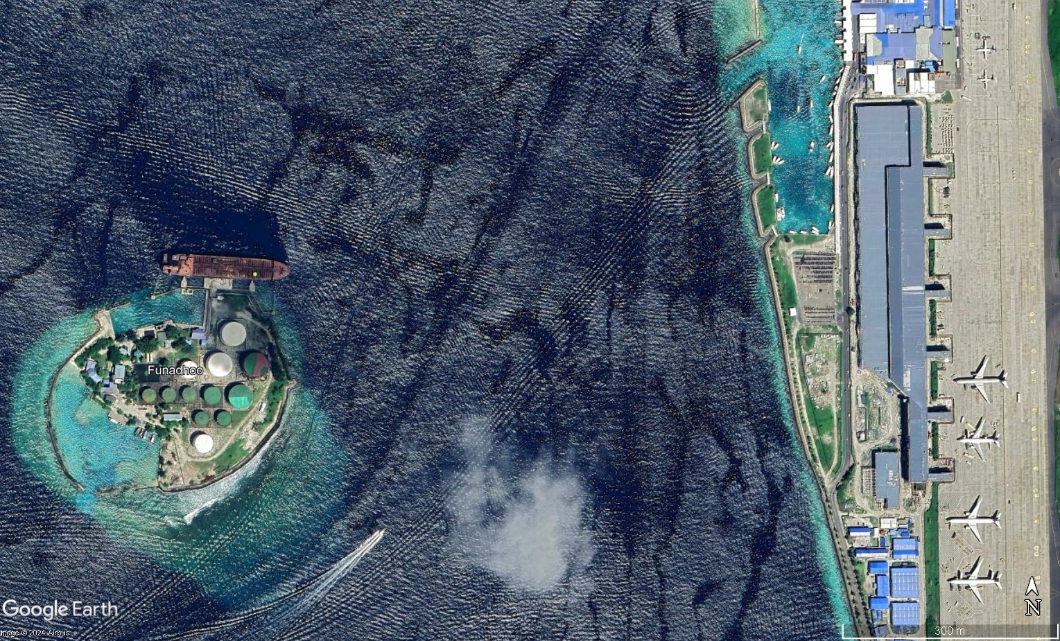
There are plans to remove the oil tanks on Funadhoo, between Velana Airport and Malé, and designate the island as an Airport Economic Zone with shopping malls, hotels,convention centres. and entertainment facilities.

Ambitious plans for the small island of Funadhoo, currently taken up by oil tanks and located to the east of Velana Aiport and close to Malé, the capital city, were announced in September 2023. President Ibrahim Mohamed Solih said that the oil tanks would be removed and replaced with a convention centre, hotel and shopping malls. On 4th January 2024, current President of the Maldives, Dr. Mohamed Muizzu, inaugurated the Velana International Airport and economic zone megaproject and pledged to develop Funadhoo Island as an international financial hub. He also revealed plans to create the ‘Maldives International Financial Services Authority’ as a step towards establishing an international financial centre in the Maldives. On 22nd January President Muizzu announced that, following relocation of the fuel storage to Maagiri Falhu, Funadhoo would be designated as a special economic zone.

Airport Expansion in Indonesia: tourism, land struggles, economic zones and aerotropolis projects

Indonesia cover mA new report Airport Expansion in Indonesia: tourism, land struggles, economic zones and aerotropolis projects has been published by the Third World Network (TWN) in partnership with GAAM. Airport expansion in Indonesia is closely intertwined with a government drive for massive tourism growth, and the 64-page report looks at 58 airports, operational, under construction and still in the planning stage.

New airports, and expansion of existing airports, frequently entails displacement of communities and loss of farmland and the report documents land rights struggles relating to 25 airport projects. Planners often hone in on forested land as an alternative to the use of agricultural land for airport projects.

Aviation expansion in Indonesia is integrated with other megparojects such as multi-lane highways and sea ports, and linked to new Special Economic Zones (SEZs). These areas are designated for industrial and tourism development, provided with surface transportation networks and other supportive infrastructure and lavished with tax breaks and other incentives. Several SEZs have been bestowed with long stretches of coastline boasting white sand beaches, natural assets that are a cornerstone of tourism.

There are many plans for aerotropolis-style development, including around two airports currently under construction in Java – Kulon Progo and Kertajati – in the face of vigorous and long standing resistance from communities being forced to leave their homes and productive agricultural land. A number of aerotropolis plans are integrated with development of tourist resorts that aspire to become aviation dependent destinations in their own right. The report accompanies GAAM’s digital map which features all the airports that are mentioned, integrating spatial information with text and images.

Since the report went to print plans for a new airport in the Seribu Islands (Thousand Islands) off the coast of Jakarta have been announced. This appears to be a scheme for tourism oriented aerotropolis style development as the Jakarta administration has stated that the winner of the tender will be permitted to build resorts near the airport, and will be provided with incentives.

For paper copies of the report, please contact:  Third World Network, 131 Jalan Macalister, 10400 Penang, Malaysia, Tel: 60-4-2266728/2266159, Fax: 60-4-2264505, Email: twn@twnetwork.org.

Mapping aviation expansion in Indonesia

Following extensive research GAAM has published a digital interactive map: Aviation expansion in Indonesia: tourism, land struggles, economic zones, and aerotropolis projects. The map includes 60 airports – operational, under construction and still at the proposal stage, plus two airport projects which were cancelled. The issue of land rights in particular is highlighted, documenting disputes and resistance against displacement relating to 25 airport projects. Two airports currently under construction in Java, Kertajati and Kulon Progo, are of particular concern because of human rights violations, including police brutality, against people resisting eviction from their homes and productive agricultural land. Aerotropolis development is planned adjoining both of these airports.

Indonesia map graphic
Screengrab of GAAM Aviation Expansion in Indonesia digital map

The digital map represents only a fraction of airport projects in Indonesia, which already has 237 operational airports with a government expansion drive aiming for 62 new airports within 15 years, bringing the total number to 299. Yet it demonstrates the exciting potential of online mapping for organizing, analyzing and presenting information. GAAM hopes to collaborate with other organizations in the development of online maps to develop a more comprehensive picture of aviation expansion and the impacts on affected communities, making the most of this wonderful technology to support our research, awareness raising and campaigning. The map was designed and produced by InTouch GIS using the Storymap app.

A forthcoming report, Aviation expansion in Indonesia: tourism, land struggles, economic zones, and aerotropolis projects, contextualizes the information in GAAM’s online map, examining the central role of aviation expansion in a government drive for tourism growth and the integration of several airport projects with other infrastructure such as road networks and ports, economic zones and aerotropolis developments. The report will be published by GAAM in partnership with the Third World Network (TWN).