Dara Sakor Airport serves tourism zone taking up 1/5 of Cambodia’s coastline

In November 2023 Cambodia’s State Secretariat of Aviation (SSCA) announced that construction of Dara Sakor Airport (Cambodia’s fourth international airport after Phnom Penh Airport, Siem Reap Airport and Sihanouk Airport) was in its final stages. Dara Sakor Airport has been built to serve a gigantic tourism-oriented economic zone, the 451 square kilometre Dara Sakor project encompassing about one-fifth of Cambodia’s coastline. The Dara Sakor developer, Coastal City Development Group Ltd., calls the project ‘Coastal City’ and its website has pictorial maps indicating the many components of the project such as Dara Sakor Airport, a resort, tourism zone, golf courses and a port. The China-Global South Project reflected on the Dara Sakor project in 2023. Of all the anticipated infrastructure only the airport was completed. Yet the project continued with ‘considerable support from the government’. BBC reporters visiting Dara Sakor in September 2023 described unfinished roads and buildings as a stark contrast with ‘dazzling brochures for potential investors’.

Pictorial map of Dara Sakor project including tourism zone, resort, golf courses, development zone and Dara Sakor International Airport. Source: Coastal City Development Group Ltd.

Thousands of people have been forcibly displaced from their homes for the Dara Sakor project, losing their farming and fishing livelihoods. There have been many protests against eviction and inadequate compensation, in many instances met with repression. Unrest dates back to the inception of the project in 2008 when 360 sq km of land in the Botum Sakor and Kiri Sakor districts in the Koh Kong Province was reclassified as state-owned land. A 99-year lease contract was signed with Union Development Group (UDG) of China. Cambodian Human Rights and Development Association (Adhoc) reported that affected communities were not consulted about the project, some only becoming aware when officials arrived to measuring land. In 2011 the project site grew to 451 sq km when UDG was granted an additional 91 sq km land concession to develop a water reservoir and hydropower. During 2011 UDG began dismantling and burning down some villagers’ houses and destroying productive trees.

A key protest took place in February 2014 when about 140 people blocked the road to UDG’s offices leading to a clash with 40 UDG security guards and six soldiers carrying AK-47 rifles. Kiri Sakor District Governor said district authorities had ordered about 100 families to vacate their land for the Dara Sakor project’s hotels, golf courses and an airport. By September 2014 5,791 people had moved to a relocation site where they lacked access to former farming and fishing areas and suffered many problems including poor quality housing damaged by wind and rain, limited water that did not meet national standards, lack of electricity and health care facilities. Reports of destruction of houses and productive trees emerged again in 2018. In april April Koh Kong Provincial Court heard testimony from 13 families claiming that 60 UDG guards had burned their productive trees, seeking compensation for loss of cassava, jackfruit, mango, rubber and coconut crops.

On 27th May 2019 about 20 residents protested in front of the Chinese Embassy in Phnom Penh, calling for resolution of the 11-year land dispute. A report by the Community Legal Education Center stated that 1,143 families were forced to vacate about 100 sq km of land in the first five years fo the project but many families had resisted and fought for rights to the land. Four villagers were detained for 12 hours on 29th September 2020, after camping outside Koh Kong Provincial Hall calling for action over the 12-year land dispute with UDG. A year later 1,333 families rejected compensation offers of between 1 and 3.5 hectares and said they would fight to remain on their land. Protests against compensation offers continues into 2022; some declined the offer as it was insufficient and the village the government wanted to relocate people to was 100 km away and lacked infrastructure.

In June 2023, just four months before SSCA’s announcement about construction of Dara Sakor Airport entering its final stages, there was yet another protest by people affected by displacement for the Dara Sakor project. A group of villagers involved in a Dara Sakor related land dispute attempted to travel to Phnom Penh to submit a petition at the Ministry of Justice, but were met with a police roadblock. Eleven villagers were arrested, forced into a truck, returned to Koh Kong and charged with criminal incitement. Radio Free Asia reported that authorities threatened further arrests after about 20 villagers gathered outside the offices where the 11 people were being detained. Human rights organization Licadho said the protesters had not caused any social disorder and that police had been sent to the the area where many of them lived.

For more information including references for all source material see the case study on EJAtlas, the world’s largest, most comprehensive online database of social conflict around environmental issues – Dara Sakor project, Cambodia.
Demolitions for ‘airport zone’ (zone aéroportuaire Modibo Kéita), Mali

Mass evictions for an ‘airport zone’ next to Modibo Keita Airport, Mali’s main airport on the outskirts of Bamako, the capital city, began on 20th April 1995. Without warning, the government began bulldozing the Senou neighbourhood to make way for expansion of the zone. Demolitions continued for ten days and about 3,707 families, approximately 30,000 people, were forcibly evicted. Further waves of demolitions followed with many instances of land grabbing and speculation. Farmers were displaced for a fertilizer plant on the land in 2007-8 and in 2009 residents resisted instructions to leave the land. A drive to clear remaining communities began in 2021. Bulldozers arrived early in the morning of 14th January, in a major eviction drive covering 1,600 hectares; about 20,000 families in 11 neighbourhoods were impacted. About 800 evictees said they had permits to occupy the land and many affected people were left destitute without shelter.

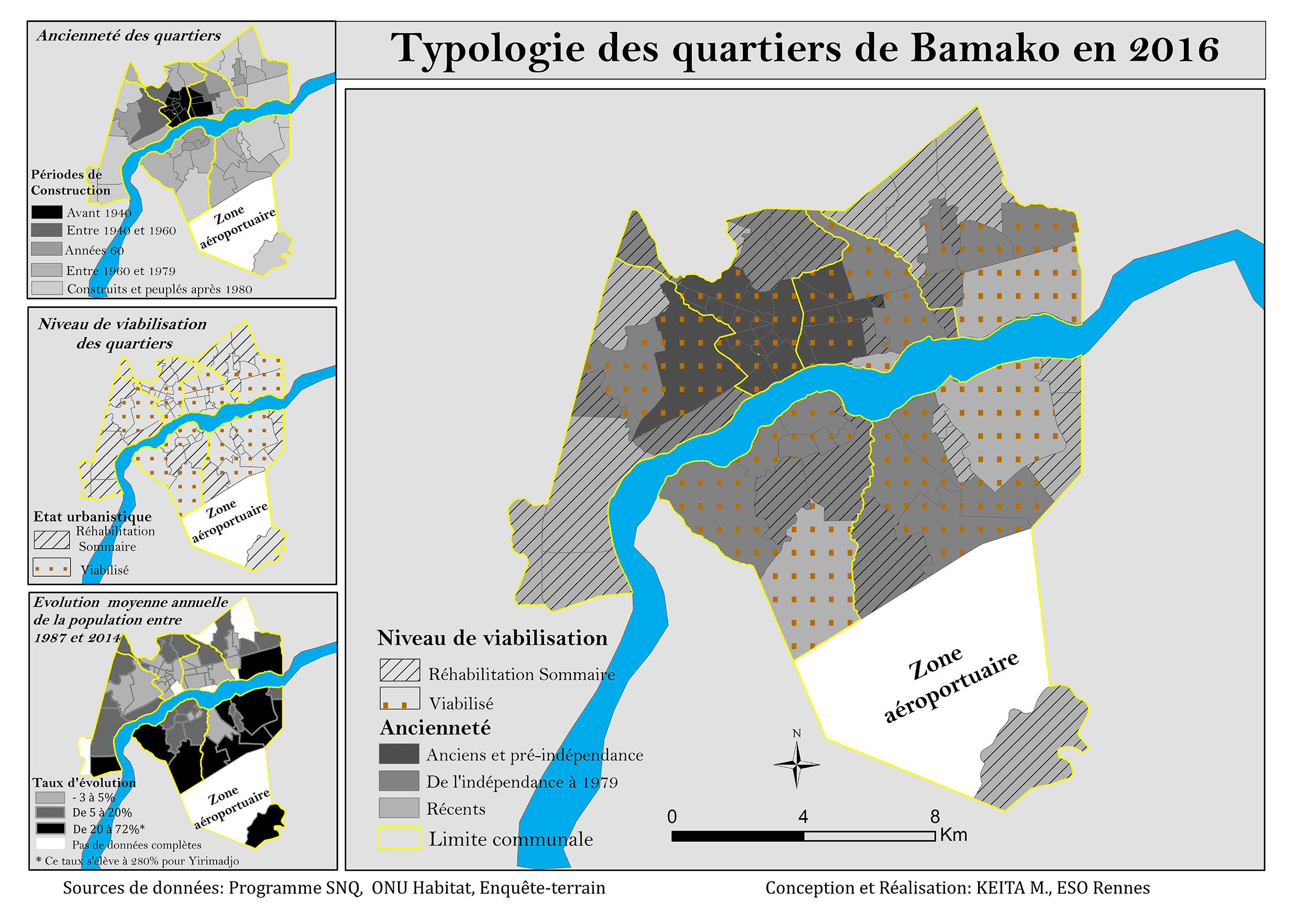
zone aéroportuaire Modibo Kéita
Map showing zone aéroportuaire Modibo Kéita. Source: https://journals.openedition.org/eps/docannexe/image/7707/img-3.png

The ‘airport zone’ – zone aéroportuaire Modibo Kéita – is vast, extending over 7,194 hectares northwest of the airport. It was classified as a plot of land for airport company use in 1999. Residents contest government claims that their occupation of the airport zone is illicit; they have lived on the land for several generations. An inhabitants’ organization – Plateforme deshabitants de la zone dite aéroportuaire (PHZA) – has been established with active groups, sometimes holding different views about land management, in many affected villages. Women, some of them elderly, play a prominent role in resistance against eviction from the ‘so-called airport zone’. The land struggle is supported by l’Union des Associations et Coordinations d’associations pour le Dévelopement et la Défense des Droits des Démunis (UACDDDD), a national federation fighting the injustices of dispossession. Demonstrations and meetings about the airport zone have been attended by hundreds of people. In November 2021 an independent national commission of inquiry to investigate demolitions in the airport area was established.

For more information about the Modibo Keita airport zone evictions see the case report on EJatlas, the world’s largest, most comprehensive online database of social conflict around environmental issues: Modibo Keith airport zone, Mali

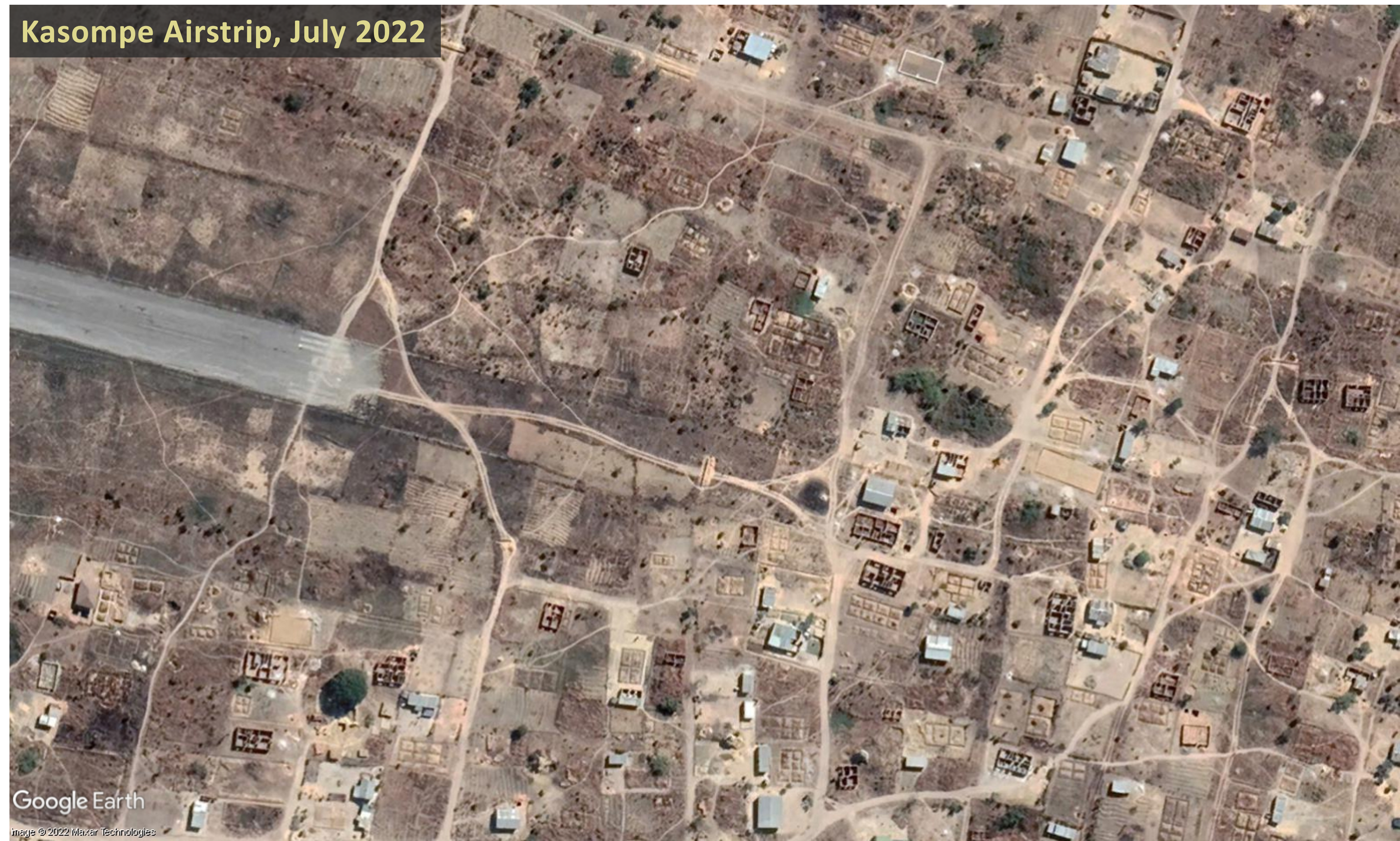
Demolition of +300 houses on Kasompe Airstrip land

On 20th August 2022, beginning at 2am, more than 300 houses built on land surrounding Kasompe Airstrip were demolished by officers from Chingola Municipal Council and the Zambia Police Service. The Council stated it had not allocated the land in question and the buildings had been erected without planning permission. Residents appealed to the government to find them alternative land and some of them attempted to resist the demolition, burning tyres and breaking the windows of bulldozers. A video of the demolition shows houses in plots of land with gardens and trees being bulldozed, as displaced people looked on.

Completed houses as well as houses still under construction were demolished. A number of residents retaliated against destruction of their homes, setting fire to two properties – a guesthouse and servants’ quarters – owned by Johnson Kang’ombe, Mayor of Chingola, whom they accused him of selling them plots of land at Kasombe Airstrip. Two suspects thought to be involved in the arson were apprehended and detained. A group of women protested chanting slogans including “The Mayor must go”. One evicted woman said that her aunt whose home was also demolished had collapsed with suspected high blood pressure.

In the aftermath of the demolitions the only help given to displaced residents was food aid and space in a camping site, provided by the Chingola District Disaster Management and Mitigation Unit (DMMU). On 29th August it was reported that Chingola District Commissioner Raphael Chimupi had said that DMMU had given relief food items to 95 out of 98 families whose houses had been demolished. Chingola Member of Parliament Chipoka Mulenga visited affected residents and promised to help them, saying “I will do everything in my power to help resolve this issue, it is saddening to see a lot of houses demolished, which has left many families in the cold.” Mulenga said the government would provide alternative land to the victims of the demolition of 345 houses, but as of 27th September 2022 some people were still stranded with nowhere to relocate to.

Satellite imagery of an area at the eastern end of the Kasompe Airstrip runway, dated 26th July and 8th September, shows some of the buildings which were destroyed on 20th August 2022. Slide the bar between the images below to compare the area before and after the demolitions.

The land conflict, inustice and human rights violations related to Kasompe Airstrip is documented on EJAtlas, the world’s largest, most comprehensive online database of social conflict around environmental issues. Kasompe Airstrip is located on the eastern outskirts of the city of Chingola, in the Copperbelt Province, a mineral rich area that is the main copper mining region in Zambia. President of the Equity and Economic Party, Chilufya Tayali, said information had surfaced indicating that the demolition of the houses was not driven by the purported illegality of allocation on plots of land but by foreign interests in a mine near Kasompe Airstrip. Aerotropolis-type plans were mentioned in 2019 when the then Mayor of Chingola, Titus Tembo, said Chingola aims to become a city with Kasompe Airstrip being part of this agenda.

The Zambia Air Force (ZAF) denied allegations that it has influenced or pressured Chingola Municipal Council to demolish the houses on Kasompe Airstrip land. ZAF Director Public Relations Lieutenant Colonel Helen Chota said rumours were incorrect and that none of the other ZAF airstrips had been encroached. Yet the day after the demolitions, on 21st August 2022, it was reported that ZAF Commander Lieutenant Colon Barry had alerted citizens to more house demolitions across the country, saying houses and other structures built within 500 metres of airport infrastructure would be demolished and that building civilian structures on or near airports is a threat to national security.

Evictions of communities close to Jacksons Airport

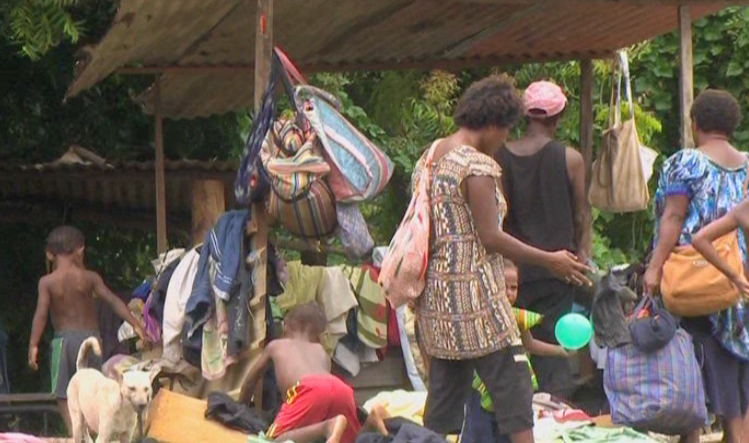
A drive to evict informal settlers living on parcels of land around Jacksons Airport, Papua New Guinea’s main airport located to the northeast of Port Moresby, was announced in the early days of 2022. Residents of the Saiwara community protested being issued with several eviction notices over the past year by the National Airports Corporation (NAC), the most recent giving them until the end of the month to vacate the area. A petition against the eviction was signed by 5,000 residents and a representative stated that they had been paying a traditional landowner for the land. Many tax-paying small and medium sized enterprises (SME’s) also urged the government to stop the evictions. A video by EMTV Online shows men, women and children protesting, some holding up placards with statements such as ‘No Eviction Please’, ‘No Eviction, What is Government doing For My Future’.

In January 2022 residents of the Saiwara community next to Jacksons Airport protested eviction notices issued by the National Airports Corporation (NAC)

Simultaneous with the eviction drive in Saiwara, NAC began pressuring residents to vacate Erima, another area adjacent to Jacksons Airport. A group of policemen visited communities and issued eviction notices. A long term resident said, “Police said the land close to the airport belongs to the National Airports Corporation and people must move out before the eviction date.” NAC managing director Rex Kiponge stated that the land belonged to NAC and that people must vacate the land by the end of January. He said, “I personally witnessed and heard from the police that any settlement or houses near the airport must be immediately moved out of force will be applied” and urged people living in the affected area to find a place to resettle.

Graphic from video showing parcels of land surrounding Jacksons Airport that the National Airports Corporation (NAC) lays claim to and where residents have been served with eviction notices. Image: Saiwara Eviction Notice, EMTV Online, 11/01/2022

A graphic in the EMTV Online video shows the parcels of land surrounding Jacksons Airport that the NAC lays claim to and where residents have been served with eviction notices. NAC managing director Rex Kiponge explained that the eviction drive was a strategic move to utilize the land for a non-aeronautical revenue stream, i.e. generation of revenue from sources other than airlines. (Typical sources of non-aeronautical revenue include retail, hotels, tourism facilities, business premises, real estate and car parking.) Kiponge also mentioned another hallmark characteristic of an aerotropolis/airport city: aspiriations for an airport to become a destination in its own right. He said that eviction of people from land around Jacksons Airport would support NAC’s new policy, namely ‘Converting Airports from Point of Transit to Point of Destination’. NAC’s focus on development of land for non-aeronautical purposes has been galvanised by a collapse in its revenue stream due to the drastic reduction in air traffic since the Covid-19 pandemic. Previously, NAC’s revenue had consisted of 80% from aeronautical business and 20% from non-aeronautical business. Kiponge said the NAC needed to start generating its own revenue and recouping its assets was in line with this aim.

Following questions in Parliament from member for Moresby North East, John Kaupa, PNG Prime Minister James Marape intervened, assuring settlers on airport-owned land at Erima and Saiwara that they would not be evicted by the NAC until a permanent solution was reached. He asked NAC to freeze their eviction plan. But the settlers are still under pressure to leave; Marape warned them not to move in onto state land and start building structures if they are not in possession of titles, saying that the Government would not step in to assist anyone on humanitarian grounds.

Over 200 families residing in Erima Bridge were evicted and left sleeping out in the open without food or water in February 2017. Photo: EMTV, 06/02/2017 (date accessed 06/02/2017)

The current drive to evict communities living around Jacksons Airport is the latest in a series. In February 2017 police evicted more than 200 families who were living on state-owned land in Erima Bridge. Some of them had lived in makeshift and semi-permanent housing for more than 20 years. The officer in charge of Jacksons Airport said the police were acting on the orders of the land owned by the NAC and that over the course of a week all the houses and tents in the area in question had been removed. It was reported that they were left sleeping out in cold, wet weather conditions for a few days. Their only shelter was wooden frames and roofing iron and they had no food, water or clothing. A settler who had moved to Erima from the Highlands region said some people whose homes were destroyed had not received an eviction notice. At the time of the Erima Bridge eviction the Asian Development Bank (ADB) confirmed support for expansion of Jacksons Airport, signing an agreement with NAC to develop a new international passenger terminal. In May 2015 a demolition exercise at another settlement near Jacksons Airport, 7 mile, left more than 200 people homeless. Some of them were beaten up by the eviction squad. Evictees lost all they owned during the demolition and some homes were burned down. The eviction was part of NAC’s development plan for Jacksons Airport.

Information about evictions of communities surrounding Jacksons Airport has been published on EJatlas, the world’s largest, most comprehensive online database of social conflict around environmental issues: Jacksons Airport and evictions from land claimed by National Airports Corporation, PNG

Residents impacted by Swaziland’s international airport still demanding compensation

In 2003 construction of an international airport in Sikhuphe, Swaziland was initiated by King Mswati III, who rules the country as sub-Saharan Africa’s last absolute monarch. From its inception commentators warned that the new airport was a waste of resources, diverting funding away from vital projects to fight poverty in Swaziland. In contrast with the one in seven of the coutnry’s inhabitants living in abject poverty King Mswati III enjoyed a lavish lifestyle with 13 palaces, fleets of luxury cars and a private jet.

September 2021 satellite imagery of King Mswati III International Airport and some of the surrounding road network

In March 2014, presiding over an expensive opening ceremony, King Mswati III unveiled the name of the new airport: King Mswati III International Airport. In the lead up to this event he had announced that a new town would be established to support the new airport, which would bring development to the surrounding communities, including Mbadlane, Hlane and Malindza. He proclaimed “After a radius of about five kilometres from the airport, urban structures will be constructed.” More than three years later, in October 2017, the Times of Swaziland reported that King Mswati III International Airport had ‘brought nothing but misery to hundreds of residents of Sikhuphe, in Malindza, where the airfield was constructed’. They had not received any compensation for their relocation, despite a consultant’s recommendation that a sum of approximately US$6 million be allocated for resettlement of 188 homesteads falling within the boundary of the so-called ‘airport city’.

There was a series of protests over impacts of airport and road construction and lack of compensation in 2021. In September, Malindza residents protested disruption of their water supply caused by construction of a road serving the airport, and demanded its restoration. They had been left struggling to access water to sustain their cultivation of vegetables and rearing of livestock after a dam was destroyed by Inyatsi, a firm with close connections to the government which was awarded construction contracts for King Mswati III International Airport along with a major highway connecting South Africa to Mozambique via the airport. In November a group of about 200 residents blocked Inyatsi’s trucks from entering the quarry near King Mswati III International Airport. It was their third protest in three months. In November 2021 some of the residents of Malindza who were displaced to make way for the project and whose houses were damaged by blasting works during construction – of the airport and road leading to it – were still demanding compensation. Blasting had caused cracks in their houses. A group of residents, mainly women, protested for almost a week and camped in the bushes. They had lost patience after struggling for compensation for almost 20 years.

Malindza residents demand compensation for damage to their houses causes by construction of King Mswati III Airport
Over 200 residents slept in the bushes demanding compensation for damage to their houses during construction of King Mswati III Airport. Photo: Swaziland News, 12/11/2021

This case of airport-related injustice is documented on EJAtlas, the world’s largest online database of social conflict around environmental issues: King Mswati II International Airport

Video – Aerotropolis: Evictions, Ecocide and Loss of Farmland, part 2

The second part of a two-part video, Aerotropolis: Evictions, Ecocide and Loss of Farmland, highlights damaging impacts of aerotropolis (airport city) projects on people and the environment. Evictions can be large scale and there are many instances of human rights violations. Allocation of large greenfield sites places farmland, forests, wetlands and coastal ecosystems at risk.

The video looks at 14 aerotropolis-type projects: Central Transport Port-CPK (Poland), Manchester Airport City (UK), Airport City Gatwick/Horley Business Park (UK), New Mexico City Airport (NAICM), (Mexico), Santa Lucia Airport (Mexico), Northwest Florida Beaches Airport (US), Vernamfield Aerotropolis (Jamaica), Hamilton Aerotropolis (Canada), Pickering Airport/Toronto East Aerotropolis (Canada), Mattala Airport (Sri Lanka), Nijgadh Airport (Nepal), Istanbul Airport (Turkey), Bulacan Aerotropolis (the Philippines) and Sanya Hongtangwan Airport (China). For further information see the comprehensive Reference list of all source material, including photos and other images. Part 1 of the video can be viewed here.

New Research: Airport projects responsible for human rights violations and ecological destruction around the world

Map of Airport-related Injustice and Resistance

Interactive map documents 80 cases of airport-related injustice and resistance

A new interactive map documents cases of airport-related injustice and resistance around the world. All across the globe airport projects are generating serious conflicts and social and environmental impacts: land acquisition, displacement of people, destruction of ecosystems, local pollution and health issues. A new map based on scientific research presents 80 cases as detailed examples of the conflicts generated by airport projects around the world. The research also identified more than 300 cases of airport projects where there is evidence of conflict, that merit further investigation. Research began in 2018 and has been jointly conducted by the EnvJustice project of the Environmental Science and Technology Institute at the Autonomous University of Barcelona (ICTA-UAB) and the Stay Grounded network. 

In many countries, airport planning, construction and expansion continues, in spite of the steep decline in air traffic since the beginning of the Covid-19 pandemic. All aviation expansion, wherever it takes place, contributes to the global problem of climate destruction. Aviation, being fossil fuel dependent and intensive, is a major and growing source of greenhouse gas emissions. By documenting a multitude of local struggles against airport projects the Map of Airport-related Injustice and Resistance contributes to a broad and diverse global movement for degrowth of aviation and transition to a just and sustainable mobility system.

“Communities around the world struggle against eviction from their homes and farmland for aviation expansion, and to protect forests, wetlands and coastal ecosystems, our research shows. Our interactive feature map, the first of its kind, documents a multitude of airport-related injustices and inspirational resistance movements,” say Sara Mingorría of EnvJustice (ICTA-UAB) and Rose Bridger Global Anti-Aerotropolis Movement (GAAM.

Many of the cases documented and analysed involve affected communities opposing  land acquisition for airport projects. In about half of those cases studied there were problems of land dispossession (50%) and displacement (47%). Many communities resisting displacement have suffered human rights violations and state repression: forced evictions, harassment, intimidation, arrests, imprisonment and violence. In around a third of the cases studied there were problems of repression (30%), militarization (29%) and the conflicts reached a high level of intensity (35.5%).

Site clearance for many airport projects also obliterates wildlife habitats and biodiversity. In 48 percent of the cases analyzed, problems of loss of landscape were registered, 41 percent involved deforestation impacts and 32 percent loss of biodiversity. 

The Map of Airport-Related Injustice and Resistance is a joint project by the EnvJustice (ICTA-UAB) and Stay Grounded. Information has been contributed by organizations, journalists, activists and academics. The research project is co-founded and coordinated by Rose Bridger (Global Anti-Aerotropolis Movement-GAAM/EnvJustice ICTA-UAB) and Sara Mingorría (Stay Grounded/EnvJustice ICTA-UAB); Yannick Deniau (Envjustice/GeoComunes) and Mira Kapfinger (Stay Grounded) joined the coordination team during the project. The 80 published cases are just the beginning of the mapping project. The research team anticipates that many more conflicts will be documented on the map as the project continues.

EJAtlas is an online database and interactive map documenting and cataloguing environmental conflict around the world. It started in 2011 and counted on the collaboration of hundreds of researchers and organizations. It is now coordinated by the ENVJUSTICE project at ICTA-UAB.

See the airport injustice cases on the Feature map

For more information see Voices from affected communities and overview of cases.

Aerotropolis: Evictions, Ecocide and Loss of Farmland, part 1

The first section of a two-part video, Aerotropolis: Evictions, Ecocide and Loss of Farmland, highlights damaging impacts of aerotropolis (airport city) projects on people and the environment. Allocation of large sites means that communities face displacement and entire ecosystems can be destroyed.

The video looks at 14 aerotropolis-type projects: New Yogyakarta International Airport, Kertajati Airport and Aerocity, Kualanamu Aerotropolis (Indonesia), 2nd Jeju Airport (South Korea), New Phnom Penh Airport (Cambodia), Long Thanh Aerotropolis (Vietnam), Taoyuan Aerotropolis (Taiwan), KXP AirportCity (Malaysia), Andal Aerotropolis, Bhogapuram Airport and Aerocity, Shivdaspura Aerocity (India), Anambra Airport City (Nigeria), Tamale Airport (Ghana) and Western Sydney Aerotropolis (Australia). For further information see the comprehensive Reference list of source material, including photos and other images.

Global map of aviation-related socio-environmental conflicts and justice movements

A global map of socio-environmental conflicts and justice movements related to aviation-related projects includes 60 cases that have already been analyzed. The map provides a wealth of information on how people and the environment can be negatively impacted by new airports and expansion of existing airports. Affected communities contend with a multitude of injustices: eviction, land dispossession, loss of farmland and fishing grounds, destruction of ecosystems, construction work impacts and health damage from aircraft pollution and noise once airport projects become operational. More than 300 such cases around the world have been registered in the research project, conducted by the EnvJustice project and the Stay Grounded network.

Global map of aviation-related conflicts and environmental justice movements produced by The EnvJustice project of the Environmental Science and Technology Institute at the Universitat Autònoma de Barcelona (Autonomous University of Barcelona) ICTA-UAB and the Stay Grounded network
Map of aviation-related conflicts and environmental justice movements around the world

Several aerotropolis or airport city projects, i.e. substantial commercial and/or industrial development constructed or planned on land surrounding or adjoining an airport, are documented and analyzed. Examples include Kertajati Airport and New Yogyakarta International Airport in Indonesia, both of which involved forcible eviction of communities from several villages from their homes and farmlands. In Cambodia, the government has approved a plan for a new Phnom Penh Airport, one of the world’s largest airports by land area, along with an associated ‘airport city’. The proposed site, predominantly agricultural land, encompasses land that Kandal Stueng villages have resided on for two decades, including communally held wetlands. About 2,000 families could be affected and hundreds of people have protested against the development.

In India, Andal Aerotropolis is a private airport city development that was stalled by sharecroppers protesting delays in receiving compensation for land taken for the project. Landowners from seven villages in Purandar sustained resistance against loss of their homes and farmland for a new airport since the location of the project was announced in 2016. Then in 2018 it was reported that the state government was forming a consortium to drive investment in an ‘airport city’ around the airport. Villagers’ resistance against displacement from their farmland for Bhogapuram Aerotropolis, also referred to as an ‘aerocity’, succeeded in reducing the land area allocated to the project from 6,000 hectares to 1,122 hectares, along with securing higher compensation for a group of farmers.

A plan for a new airport on the Arial Beel wetlands in Bangladesh is an example of a aerotropolis-type megaproject that was halted by mass mobilisation. A vast swath of land had been earmarked for development, 10,117 hectares for the airport and an accompanying ‘satellite city’, and the farming and fishing livelihoods of thousands of people were set to be seriously affected with wetlands paved over. The government cancelled the project after major protests, the largest of which involved 30,000 people. In the Philippines, mangroves, coastal wetlands providing a vital habitat for many species and protection from erosion and flooding, have already been destroyed to make way for the proposed Bulacan Aerotopolis which threatens to destroy fishing livelihoods. Airport projects can entail deforestation. In Nepal, the proposed Nijgadh Airport, a massive 8,000 hectare aerotropolis, raises the prospect of over 2.4 million trees being felled.

A number of airport projects shown on the map are key components of tourism development schemes that are based upon aviation dependency. A proposed new airport on the Island of Fainu, in The Maldives, is accompanied by a plan for an adjoining hotel. The project would destroy a long stretch of white sand coastline, dense forest and agricultural land, the airport and hotel projects combined swallowing up much of the small island. Another example is the Philippine island of Sicogon where, in the aftermath of the devastation wreaked by Typhoon Yolanda, developers seized upon the opportunity for tourism development, the first phase of which includes an airport specifically for tourism along with beachfront accommodation. Disaster capitalism is also evident in the Caribbean island of Barbuda where land clearance for construction of a new airport, intended to support tourism growth in particular high-end resorts, began shortly after residents were evacuated following Hurricane Irma.

The map includes two major airports built to support fossil fuel projects. Uganda’s second international airport, Hoima Airport, currently under construction, is a key component of the 29 square kilometre Kabaale Petrochemical Industrial Park. With a 3.5 kilometre length runway, capable of accommodating the world’s largest cargo aircraft, it is envisaged that in its first phase of operations Hoima Airport will handle delivery of heavy equipment for the oil refinery on the site. In a similar vein, Komo Airfield, in the southern highlands of Papua New Guinea, has the country’s longest runway and was built for delivery of heavyweight and outsize equipment for the ExxonMobil led PNG LNG (liquefied natural gas) project.

A number of cases shown on the map involve allocation of larger areas of land than would be required for aviation operations, increasing the number of people potentially facing displacement due to land acquisition, but without clear information on what the excess land might be utilized for. For example, in Nigeria the Cross River State government intends to acquire 900 hectares of land for a proposed Obudu International Passenger and Cargo Airport and people have been evicted from their homes and farmlands. In a similar case in Nigeria, bulldozers arrived without warning to clear 4,000 hectares of farmland where crops including cocoa, palm trees and bananas were cultivated for a cargo airport in Ekiti. This airport project is one instance of a successful court case where affected people secured a court victory that halted the airport project. Also in Nigeria, about 5,000 people from 20 villages could be affected by a proposed Ogun cargo airport and hundreds of farmers protested against land-grabbing.

In addition to the 60 airport-related cases already included, a great many further cases have been registered as meriting further investigation. A total of 300 cases have been registered. The information gathered for the global map has been provided by a wide variety of organizations, local collectives and academics. The research team is coordinated by Rose Bridger (Stay Grounded) and Sara Mingorria (ICTA-UAB). This already substantial database and interactive map related to airports is part of Ejatlas, the biggest global inventory of socio-environmental conflicts around the world. As of 11th July 2019 2,831 cases were registered on Ejatlas and this is anticipated to increase to 3,000 cases by the end of the year.

Maps of New Mexico City International Airport (NAICM) and aerotropolis

GAAM is delighted to share an incredibly informative set of maps elucidating the complex socio-economic and environmental impacts of construction of New Mexico City International Airport (NAICM). The maps were produced by GeoComunes, a collective working with communities to use maps as an analytical tool to strengthen the struggle for defence of common goods, in collaboration with affected residents and NGOs supported by Coordinadora de Pueblos y Organizaciones del Oriente del Estado de México (CPOOEM), which supports people’s defence of land, water and culture in eastern Mexico. The NAICM site, covering over 4,431 hectares, is the waterlogged Texcoco lakebed. Aerotropolis development is planned: a specific area within the airport site and commercial and industrial development over an extensive area surrounding it.

NAICM maps

The first map, below, shows uncontrolled urbanization between 2000 and 2015, preceded by highway expansion, driven by real estate and encroaching on ejidos (communally held agricultural land) near the shores of Texcoco Lake. Landfill sites receiving waste from Mexico City have damaged farmland and polluted aquifers. The airport site is in the ‘Zona Federal’ area in the centre of the map. The existing Mexico City International Airport (officially named Benito Juárez International Airport) is shown near the bottom of the map.NAICM map 1

A perimeter fence has been erected around the NAICM Phase 1 project area. The site includes ejidal lands, in spite of assurances that the airport would be built entirely on federally-owned land. Ejidal lands were also appropriated for a highway and housing developments, and many Ejidos (land holders) were violently evicted by state security forces. Plans for Aerotropolis phase 1 include a shopping mall, hotels, industrial park, exclusive high-end housing, golf courses and a free trade zone. NAICM map 2

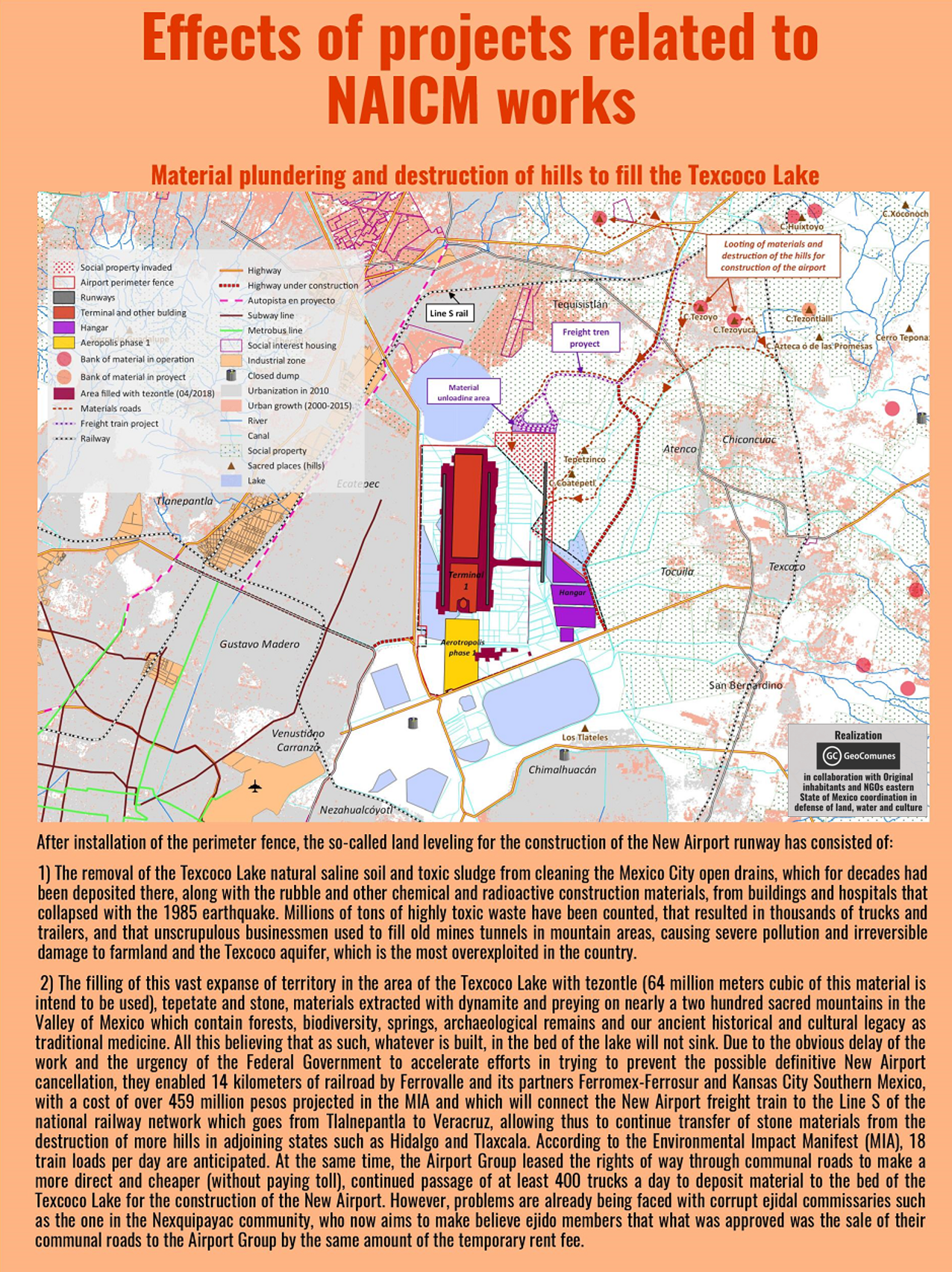
The third map shows satellite imagery of the three Ejido areas directly affected by airport construction. Over 330 hectares of ejidal lands, in the communities of Ixtapan, Nexquipayac and Atenco, were seized from its rightful owners by the government and now lie within the NAICM perimeter fence.NAICM map 3

Land-levelling to prepare the site for construction of the airport involved clearing saline sludge from the lakebed and toxic waste that has been dumped, polluting the Texcoco aquifer and damaging farmland. Extraction of materials for use in has had a devastating impact on sacred mountains, in the Valley of Mexico. Blasting with dynamite has damaged, forests, biodiversity, springs and archaeological remains. It is estimated that 64 million tonnes of tezontle (red volcanic rock) along with stone and other materials, carried on 400 trucks per day, will be deposited to fill in the Texcoco lakebed.NAICM map 4

Water drained from the Lake Texcoco area will be channelled into Nabo Carrillo, an artificial lake and newly created lagoons, along with water from the area east of the airport site channelled via several culverted rivers. Lying at the bottom of a downward slope the airport site is at risk of flooding from concentration of water flow in this area. The flood risk could become more severe as Texcoco lakebed is sinking at a rate of about 12 inches annually. NAICM map 5

An extensive road network linking NAICM to key urban centres is planned and under construction, encroaching on ejidal land and opening up additional land for real estate and commercial development. Many of the roads are toll roads which will generate profits for construction firms holding the concessions and thus set to benefit from the traffic flow.NAICM map 6

Data from all the maps is combined in the final map, which covers a wider geographical area revealing the extent of the urbanization that is underway and planned. See the larger version of the map for more detail. NAICM is shown within a wider context as the most important of, and the focal point for, a series of megaprojects combining to form a ‘Megalopolis’, an agglomeration of cities and other urban areas. New road and rail corridors will foster further real estate development. Mexico City already suffers chronic water shortages and springs and groundwater are over-exploited. The current model of urbanization will increase stress on water supplies and aqueducts are planned to access more distant sources.  NAICM map 7 s

All the maps of NAICM and aerotropolis plans can be seen here in their entirety and are best viewed on the largest computer screen that you can find so you can zoom in and see the intricate detail.