Lio Tourism Estate and Airport ancestral land dispute triggers cease-and-desist-order

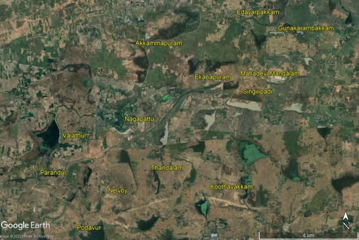
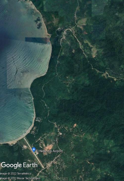
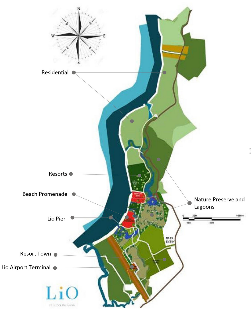
Lio Tourism Estate, a masterplanned luxurious development in El Nido, on the northern tip of Palawan – owned by Ayala, one of the largest conglomerates in the Philippines, and operated by one of its many subsidiaries, Ten Knots Philippines Inc. (TKPI) – encompasses a large 325-hectare site. As well as high-end hotels the resort contains its own private airport, Lio Airport, owned and operated by TKPI for the exclusive use of its aircraft. As with most airports worldwide the response to Covid-19 led to Lio Airport reducing operations, but by March 2022 about 600 passengers were flying in and out each day. AirSwift Philippines operates flights between Lio Airport and Manila. There is also a jetty port for visitors to embark on island-hopping boat trips. The tourism project, on a former copra (coconut) farm, began with construction of the airport and seaport to provide access, followed by accommodation and retail facilities. Shown below are satellite imagery and a site development plan published by a property firm.

But the Tagbanua Tandulanen Indigenous People (IP) claim that the project encroaches on their ancestral lands. In April 2021 their attorneys requested that the Department of Tourism (DOT) and Local Government Unit of El Nido cancel, revoke or deny applications for building permits and licenses for more than seven Ayala-owned businesses and projects in El Nido, including Lio Tourism Estate and Lio Airport. The IP group claimed ‘rampant and widespread’ proliferation of illegal transfers and conversion of their ancestral domain. On 15th March 2022, following reports of projects and activities that did not comply with Free and Prior Informed Consent (FPIC) requirements, the National Commission on Indigenous Peoples (NCIP) intervened in the land dispute, issuing a cease-and-desist-order (CDO) ordering temporary halt of projects in Barangays Libertad and Pasadeña. After issuing four notices to comply with the CDO NCIP issued a show cause order to TKPI on 13th February 2022. In March Tagbanua Tandulanen IP’s legal counsel said the group been sending letters to TKPI for two years without receiving a serious response and urged NCIP to maintain the CDO.

Extending northwards of the tourism estate developed area and Lio Airport is a 4.2 kilometre stretch of white sand beach, also part of the resort. In September 2017 the management of Lio Tourism Estate dismissed accusations that its recently opened upscale resort had blocked access to the public beach in front of it for residents of Barangay Villa Libertad. The issue stemmed from a complaint to the Palawan Provincial Board’s Environment Committee. A month previously Board Member Winston Arzaga said they had been asked by local officials to help resolve the issue, saying “The cause of it all is the access of local fishermen to their traditional fishing grounds which the Ayala management had somehow restricted.” A Safeguards Due Diligence Report for El Nido tourism development, prepared by the Tourism Infrastructure and Economic Zone Authority (TIEZA) for the Asian Development Bank (ADB), published in May 2021, includes notes of a consultation on fisheries management concerns and livelihood projects with Barangay Officials of Villa Libertad, which covers Lio beach, part of Lio Tourism Estate. Dwindling fish catch was the major fisheries issue identified by informants, resulting from overfishing and a reduced fishing area. Declining fish catch and reduced access to fishing grounds was also mentioned in relation to three other Ayala resorts in El Nido, on the islands of Miniloc, Pangulasian and Lagen.

More information about the land dispute and issues with access to fishing grounds related to Lio Tourism Estate and Lio Airport has been published on EJatlas, the world’s largest, most comprehensive online database of social conflict around environmental issues: Lio Tourism Estate and Lio Airport

Long term land tensions over Nadzab Airport Redevelopment Plan (NARP) and Airport City

Plans for airport city style development at Nadzab Airport – located 42km to the northwest of Lae, capital of the Morobe Province and Papua New Guinea’s second largest city – emerged in a 2011 masterplan for future growth of the airport both as an aeronautical hub and as a commercial and industrial centre. Nadzab Airport’s extensive land holding was earmarked for development and expansion over a time-frame of 50-70 years. The graphic below, showing a business hub next to the airport, is from Nadzab Central Strategic Plan, produced by Planpac and identifying development opportunities for 700 hectares of greenfield land.

Nadzab Central Strategic Plan. Graphic: PLANPAC
In 2012 PLANPAC developed a Strategic Land Use Masterplan for Nadzab Central Strategic Plan, a business hub next to Nadzab Airport, with 700 hectares of greenfield land on a 1,100 hectare site. Graphic: PLANPAC

Tensions between clans over ownership of land parcels date back to the inception of the airport project, in 1972 when the country was under Australian colonial administration. A loan agreement between the Japan International Cooperation Agency (JICA) and the PNG government – for ¥26,942 million (USD225.2 million) of an estimated project cost of ¥32,246 million (USD269.6 million) – was signed on 14th October 2015 and the project came to be known as Nadzab Airport Redevelopment Plan (NARP). Plans for an Airport City were mentioned in 2017 and in February 2020 NARP project manager said it was a major airport and city development and the provincial government must help address landowner issues. Prime Minister James Marape tasked Lands and Planning Minister John Rosso to start mobilising landowners in preparation for the project. In April 2021 PNG National Airports Corporation (NAC) managing director and chief executive Rex Kiponge said that upon completion of NARP the airport city concept would be rolled out, saying “When the airport is complete, the commercial aspects of the airport business hub must complement it.”

The village of Gabsongkeg is at the centre of NARP and landowners have made repeated calls for consultation, participation in the project and spin-off business opportunities. In 2020 landowners were disappointed that construction and security contracts were awarded to outsiders overlooking reputable local businesses. In January 2022 it was reported that only a small number of landowners were benefitting from leasing their customary land for associated businesses. Local people impacted by airport development still lack clean running water, electricity and adequate health facilities. NARP and other projects, such as a 4-lane highway and gold and copper mining, have triggered an influx of people, disrupting the social fabric and leading to increased social problems including violence, killings and drug & alcohol abuse. The area lacks a police station to address these issues.

Serious social problems of rape, underage marriage and prostitution specifically harm women. And women have been marginalized in land-related negotiations and decisions due to government assumptions of patrilineal land descent. Yet in the midst of these difficulties 60 Gabsongkeg women – planning ahead as most of the land in Gabsongkeg where coconut, plantain, cocoa and other trees are cultivated, is set to be taken over by the Nadzab township development – have established table markets selling food and other goods. They have increased their incomes and aim to grow their ventures into small-medium sized enterprises to support their families in the future.

Further information about contested land and other issues arising from Nadzab Airport has been published on EJatlas, the world’s largest, most comprehensive online database of social conflict around environmental issues: Nadzab Airport Redevlopment Plan (NARP) and Airport City, PNG

Evictions of communities close to Jacksons Airport

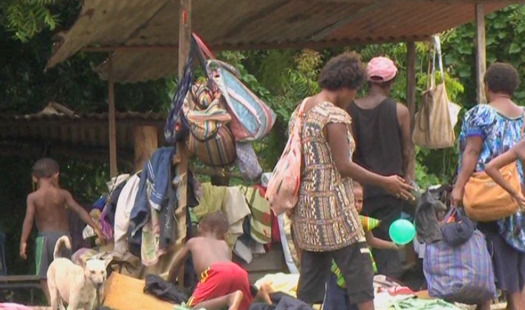
A drive to evict informal settlers living on parcels of land around Jacksons Airport, Papua New Guinea’s main airport located to the northeast of Port Moresby, was announced in the early days of 2022. Residents of the Saiwara community protested being issued with several eviction notices over the past year by the National Airports Corporation (NAC), the most recent giving them until the end of the month to vacate the area. A petition against the eviction was signed by 5,000 residents and a representative stated that they had been paying a traditional landowner for the land. Many tax-paying small and medium sized enterprises (SME’s) also urged the government to stop the evictions. A video by EMTV Online shows men, women and children protesting, some holding up placards with statements such as ‘No Eviction Please’, ‘No Eviction, What is Government doing For My Future’.

In January 2022 residents of the Saiwara community next to Jacksons Airport protested eviction notices issued by the National Airports Corporation (NAC)

Simultaneous with the eviction drive in Saiwara, NAC began pressuring residents to vacate Erima, another area adjacent to Jacksons Airport. A group of policemen visited communities and issued eviction notices. A long term resident said, “Police said the land close to the airport belongs to the National Airports Corporation and people must move out before the eviction date.” NAC managing director Rex Kiponge stated that the land belonged to NAC and that people must vacate the land by the end of January. He said, “I personally witnessed and heard from the police that any settlement or houses near the airport must be immediately moved out of force will be applied” and urged people living in the affected area to find a place to resettle.

Graphic from video showing parcels of land surrounding Jacksons Airport that the National Airports Corporation (NAC) lays claim to and where residents have been served with eviction notices. Image: Saiwara Eviction Notice, EMTV Online, 11/01/2022

A graphic in the EMTV Online video shows the parcels of land surrounding Jacksons Airport that the NAC lays claim to and where residents have been served with eviction notices. NAC managing director Rex Kiponge explained that the eviction drive was a strategic move to utilize the land for a non-aeronautical revenue stream, i.e. generation of revenue from sources other than airlines. (Typical sources of non-aeronautical revenue include retail, hotels, tourism facilities, business premises, real estate and car parking.) Kiponge also mentioned another hallmark characteristic of an aerotropolis/airport city: aspiriations for an airport to become a destination in its own right. He said that eviction of people from land around Jacksons Airport would support NAC’s new policy, namely ‘Converting Airports from Point of Transit to Point of Destination’. NAC’s focus on development of land for non-aeronautical purposes has been galvanised by a collapse in its revenue stream due to the drastic reduction in air traffic since the Covid-19 pandemic. Previously, NAC’s revenue had consisted of 80% from aeronautical business and 20% from non-aeronautical business. Kiponge said the NAC needed to start generating its own revenue and recouping its assets was in line with this aim.

Following questions in Parliament from member for Moresby North East, John Kaupa, PNG Prime Minister James Marape intervened, assuring settlers on airport-owned land at Erima and Saiwara that they would not be evicted by the NAC until a permanent solution was reached. He asked NAC to freeze their eviction plan. But the settlers are still under pressure to leave; Marape warned them not to move in onto state land and start building structures if they are not in possession of titles, saying that the Government would not step in to assist anyone on humanitarian grounds.

Over 200 families residing in Erima Bridge were evicted and left sleeping out in the open without food or water in February 2017. Photo: EMTV, 06/02/2017 (date accessed 06/02/2017)

The current drive to evict communities living around Jacksons Airport is the latest in a series. In February 2017 police evicted more than 200 families who were living on state-owned land in Erima Bridge. Some of them had lived in makeshift and semi-permanent housing for more than 20 years. The officer in charge of Jacksons Airport said the police were acting on the orders of the land owned by the NAC and that over the course of a week all the houses and tents in the area in question had been removed. It was reported that they were left sleeping out in cold, wet weather conditions for a few days. Their only shelter was wooden frames and roofing iron and they had no food, water or clothing. A settler who had moved to Erima from the Highlands region said some people whose homes were destroyed had not received an eviction notice. At the time of the Erima Bridge eviction the Asian Development Bank (ADB) confirmed support for expansion of Jacksons Airport, signing an agreement with NAC to develop a new international passenger terminal. In May 2015 a demolition exercise at another settlement near Jacksons Airport, 7 mile, left more than 200 people homeless. Some of them were beaten up by the eviction squad. Evictees lost all they owned during the demolition and some homes were burned down. The eviction was part of NAC’s development plan for Jacksons Airport.

Information about evictions of communities surrounding Jacksons Airport has been published on EJatlas, the world’s largest, most comprehensive online database of social conflict around environmental issues: Jacksons Airport and evictions from land claimed by National Airports Corporation, PNG

Residents impacted by Swaziland’s international airport still demanding compensation

In 2003 construction of an international airport in Sikhuphe, Swaziland was initiated by King Mswati III, who rules the country as sub-Saharan Africa’s last absolute monarch. From its inception commentators warned that the new airport was a waste of resources, diverting funding away from vital projects to fight poverty in Swaziland. In contrast with the one in seven of the coutnry’s inhabitants living in abject poverty King Mswati III enjoyed a lavish lifestyle with 13 palaces, fleets of luxury cars and a private jet.

September 2021 satellite imagery of King Mswati III International Airport and some of the surrounding road network

In March 2014, presiding over an expensive opening ceremony, King Mswati III unveiled the name of the new airport: King Mswati III International Airport. In the lead up to this event he had announced that a new town would be established to support the new airport, which would bring development to the surrounding communities, including Mbadlane, Hlane and Malindza. He proclaimed “After a radius of about five kilometres from the airport, urban structures will be constructed.” More than three years later, in October 2017, the Times of Swaziland reported that King Mswati III International Airport had ‘brought nothing but misery to hundreds of residents of Sikhuphe, in Malindza, where the airfield was constructed’. They had not received any compensation for their relocation, despite a consultant’s recommendation that a sum of approximately US$6 million be allocated for resettlement of 188 homesteads falling within the boundary of the so-called ‘airport city’.

There was a series of protests over impacts of airport and road construction and lack of compensation in 2021. In September, Malindza residents protested disruption of their water supply caused by construction of a road serving the airport, and demanded its restoration. They had been left struggling to access water to sustain their cultivation of vegetables and rearing of livestock after a dam was destroyed by Inyatsi, a firm with close connections to the government which was awarded construction contracts for King Mswati III International Airport along with a major highway connecting South Africa to Mozambique via the airport. In November a group of about 200 residents blocked Inyatsi’s trucks from entering the quarry near King Mswati III International Airport. It was their third protest in three months. In November 2021 some of the residents of Malindza who were displaced to make way for the project and whose houses were damaged by blasting works during construction – of the airport and road leading to it – were still demanding compensation. Blasting had caused cracks in their houses. A group of residents, mainly women, protested for almost a week and camped in the bushes. They had lost patience after struggling for compensation for almost 20 years.

Malindza residents demand compensation for damage to their houses causes by construction of King Mswati III Airport
Over 200 residents slept in the bushes demanding compensation for damage to their houses during construction of King Mswati III Airport. Photo: Swaziland News, 12/11/2021

This case of airport-related injustice is documented on EJAtlas, the world’s largest online database of social conflict around environmental issues: King Mswati II International Airport

Aerotropolis: Evictions, Ecocide and Loss of Farmland, part 1

The first section of a two-part video, Aerotropolis: Evictions, Ecocide and Loss of Farmland, highlights damaging impacts of aerotropolis (airport city) projects on people and the environment. Allocation of large sites means that communities face displacement and entire ecosystems can be destroyed.

The video looks at 14 aerotropolis-type projects: New Yogyakarta International Airport, Kertajati Airport and Aerocity, Kualanamu Aerotropolis (Indonesia), 2nd Jeju Airport (South Korea), New Phnom Penh Airport (Cambodia), Long Thanh Aerotropolis (Vietnam), Taoyuan Aerotropolis (Taiwan), KXP AirportCity (Malaysia), Andal Aerotropolis, Bhogapuram Airport and Aerocity, Shivdaspura Aerocity (India), Anambra Airport City (Nigeria), Tamale Airport (Ghana) and Western Sydney Aerotropolis (Australia). For further information see the comprehensive Reference list of source material, including photos and other images.

Land acquisition for proposed aerotropolis in Kedah, Malaysia

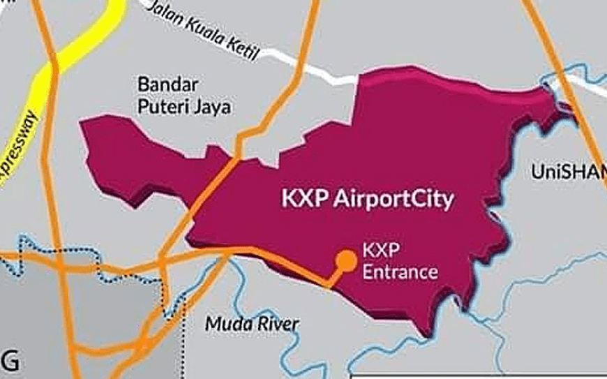
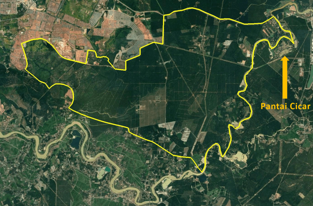
A proposed aerotropolis in Malaysia, KXP AirportCity, is one of a number of strategic infrastructure projects under the Northern Corridor Economic Region (NCER) Strategic Development Plan 2021-2025. The project, also referred to as Kedah Aerotropolis, comprises a new airport, Kulim International Airport and Sidam Logistics, Aerospace and Manufacturing Hub (SLAM). The Kedah Aerotropolis page on the NCER website describes an aerotropolis as ‘a metropolitan subregion whose infrastructure, land use and economy are centred on an airport’. It states that the proposed development would take up 9,841 acres (3,983 hectares) of land and that ‘KXP has readily available land that can cater for its expansion for the next 20 to 50 years’. Images in the sildeshow below show: a map of the proposed KXP AirportCity site with associated road development including a new expressway interchange, an aerial image with a digitised boundary of the proposed site, predominantly consisting of farmland, and a Kedah Aerotropolis infographic.

The Kedah state government appointed KXP AirportCity Holdings (KAHSB) to manage and coordinate construction of Kulim Airport. In February 2020, after witnessed a signing ceremony between the CEO of KAHSB and Aeroport de Paris Ingenierie (ADPI), the firm appointed to draw up a development master plan for KXP, Kedah Menteri Besar (Chief Minister) Mukhriz Mahathir invited airport investors, operators and concession holders to invest in the project. He said “The risks of uncertainties regarding land acquisition have been settled” and announced that 3,982 hectares of land had been gazetted to KXP and the Federal Government had approved a “large loan facility” for Kedah to acquire the land, currently belonging to private owners.

But land acquisition for KXP AirportCity met with a protest by villagers concerned they would lose their land and livelihoods. Many Pantai Cicar villagers were concerned that land they had lived on for almost a century could be lost as it was within the area earmarked for construction of the airport city project. On 28th February 2020 about 300 residents of Pantai Cicar village gathered in front of the mosque to protest against land acquisition for the proposed KXP project. The chairman of a village action committee said the earmarked land included more than 200 houses, the mosque that had been built by the community and the cemetary where their ancestors were buried. Implementation of the airport project would impact upon residents whose main livelihoods are from rubber tapping, working on palm plantations and self-employment.

On 28th February 2020 about residents of Pantai Cicar village protested against proposed construction of KXP AirportCity / Kulim Airport in their village, Sinar Hinan, 2nd March 2020

A video of the 28th February protest against taking Pantai Cicar village land for KXP AirportCity shows a large gathering of people. Some of the banners at the protest are written in English and read:

OUR LAND FOR NEXT GENERATION AND NOT FOR NEW AIRPORT, WHY NEED TO CONSTRUCT NEW AIRPORT AT TRADITIONAL VILLAGES

DON’T TAKE OUR BELOVED VILLAGE, AVOID THE KXP, FROM OUR VILLAGE, MOVE THE KXP TO THE PKNK OWN PROPERTY

DON’T DISTURB OUR COMMUNITY WITH NEW AIRPORT PROJECT

OUR LAND FOR NEXT GENERATION AND NOT FOR NEW KXP CITY & AIRPORT

WE LOVE STAY UNITY. PLEASE DON’T DEVIDE US WITH SPLIT SETTLEMENT, WE DO NOT NEED NEW AIRPORT AT THIS MOMENT

WE LOVE STAY UNITY. PLEASE DON’T DEVIDE US WITH SPLIT SETTLEMENT, DEALING WITH BIAS NOT OUR CULTURE!

At the time of the protest preparations were underway to hand over a memorandum containing almost 1,000 residents’ signatures to the state government. In addition to Pantai Cicar several nearby villages were also listed in the proposed land acquisition: Kuala Sedim, Jerung, Kemumbong, Lubuk Kiab, Batu Pekaka and Tanah Licin. The local government and housing committee chairman said the Kedah state government would investigate and review the project’s impact on the environment, saying planning was just beginning and there would be a discussion session.

Since a Kulim airport project was being considered in 2014 there has been an emphasis on potential air cargo operations. In December 2014 Mukhriz said the Kedah state government planned to construct an ‘aerocity’ at the proposed Kulim Airport; an industrial and business area, located on what was at that juncture specified as a 600 hectare airport precinct, would “accommodate all industries related to air transportation”. In March 2015 Mukhriz said Kulim Airport would initially operate as a cargo facility. In November 2020 KXP was described as ‘an airport city that will be an integral part of the Kedah Aerotropolis economic region driven by intermodal connectivity focussing on cargo, logistics and industrial development’. It is envisaged that Kulim Airport’s cargo facilities and the development of the aerotropolis will be complemented by the Sidam Logistics, Aerospace and Manufacturing Hub (SLAM).

Allegations of land encroachment for Anambra Airport City/Cargo Airport

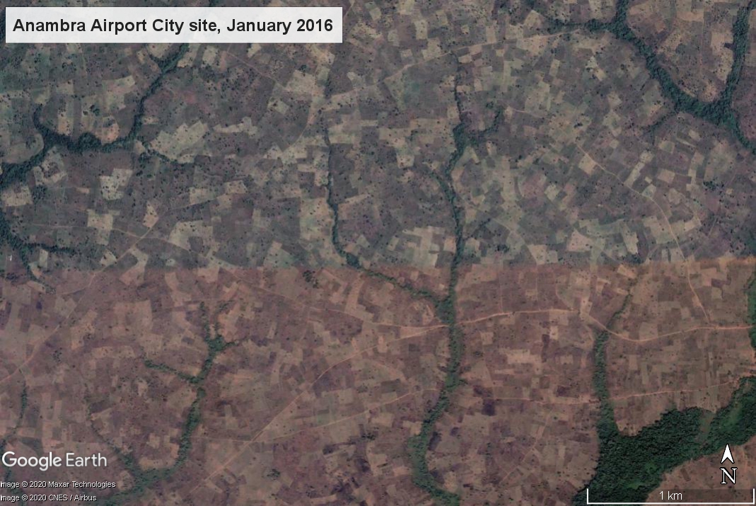
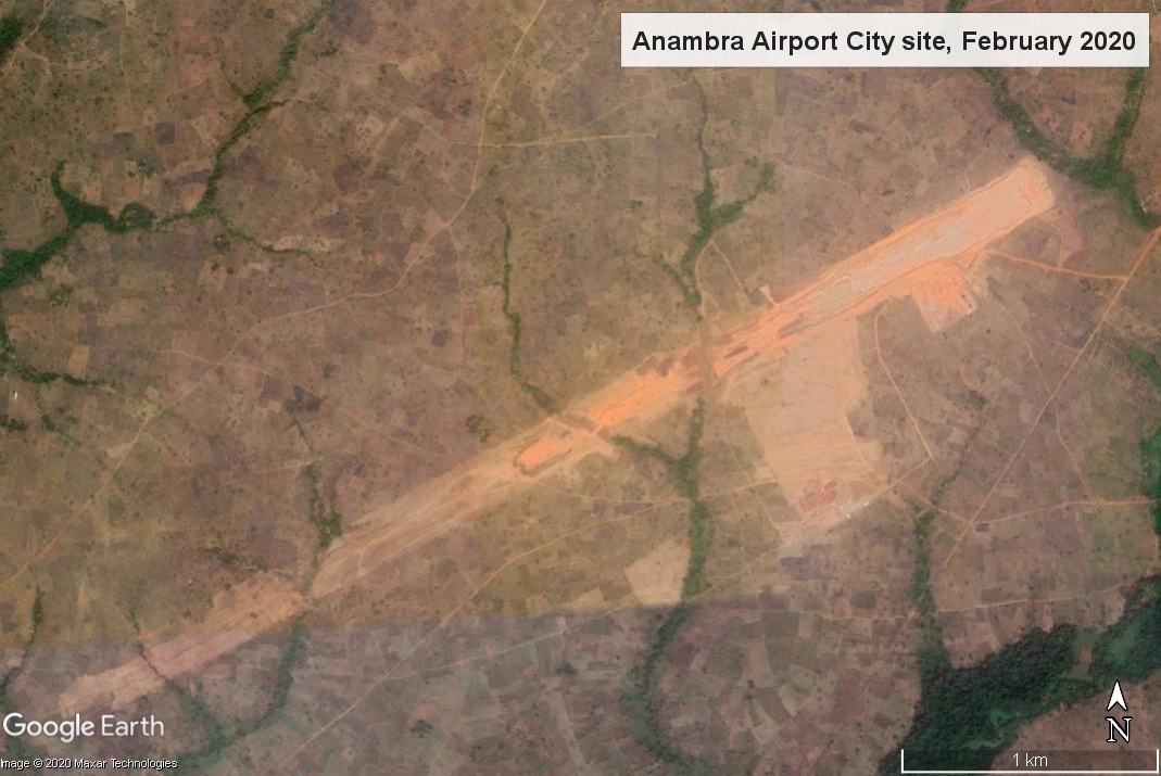
A large area of farmland was cleared for an airport city/cargo airport in Anambra, southern Nigeria and neighbouring communities complain of expansion of the project site and land grabbing. Two satellite images of the site show major changes over a four year period. The image on the left shows the airport site in January 2016, before announcement of the project, containing many plots of farmland. On the right, an image dated February 2020 shows a large expanse of farmland has been cleared for Anambra Airport City runway and other facilities.

Slide bar in the middle of the two images to see changes to landscape from clearing farmland for airport construction

The Anambra Airport City project, also also referred to as Umueri Airport City and Anambra Cargo Airport, was launched in April 2017. A two-runway airport with an airport hotel, business park, international convention centre along with aviation fuel and aircraft maintenance facilities, costing more than USD2.2 billion was announced by the governor of Anambra State, Willie Obiano. Two years later a large expanse of land had been cleared but little work had been done on the site. Igbo Renaissance Council stated that the employment for local people that was promised had not materialized and residents whose homes had been razed to make way for the project had been left ‘dejected and depressed with no sign of hope on the horizon’.

In July 2020 – in the midst of the Covid-19 pandemic, with airports that had been closed since March only slowly recommencing operations – residents of several communities around the Anmbra Airport site complained that government agents responsible for executing the project were encroaching beyond the boundary of the land area that had been allocated. People of Umuopo, Umuinu and Enuagu kindreds in Umueri, north of the airport site, stated that they were being dispossessed of their remaining portions of land and had been “thrown into pains and agony“. They said the government was deliberately making them refugees on their own land. Community investigation revealed that unscrupulous individuals were annexing their land and they called on the state government for help, stating:

“By extending their hand into other portions of our land, what does the government expect us to survive with as we are just farmers? We have written, we have cried, we have pleaded and we have engaged in all forms of diplomacy to demand that government restricts itself to the agreed portion of land, all to no avail.”

It was also reported that residents of Ifite Nteje, a community to the south of the Anambra airport project, were suffering from violence meted out by youths who had seized communal land. A band of youths had ‘unleashed mayhem on the community, sacking villagers from their homes’. People opposing sale of their communal land had been beaten with many being injured and homes had been burned down. Members of the community said the crisis had ‘brought hunger and famine as they no longer have land for farming’ and ‘they dared no go to their farms anymore for fear of being maimed, while the women among them were raped’. One woman, a widow, said their formerly peaceful community had been taken over by violence and she was one of many women who no longer had land to farm that they needed to feed their families.

On 14th October 2020 it was reported that youths from the Umueri community had dispersed bulldozers that had been had been stationed, without notice, to demolish farmland and privately owned agro-investments. A farm owner maintained his affected farm was not within the airport area and appealed for intervention from the state government to halt trespassing. On 19th October residents of Umuopo, Enuagu and Umuinu protested against alleged encroachment on their land, lighting a bonfire and blocking the road to the airport site. Some of the placards read: “We can’t be refugees and IDPs in our own land”; “We’re farmers why collect our land to build housing estate”; “Anambra State government go to the portion of land given for the airport.” The protestors described the government’s action as a deliberate attempt to impoverish the people, who were predominantly farmers. The Chairman of Ifite Umueri Community claimed that they had given the government 729.60 hectares for the airport project, but over 1,901 hectares had been taken.

Obiano, Anambra State governor, continues to support the Anambra Airport project, saying it will have the second longest runway in Nigeria after Murtala Muhammed Airport in Lagos. Then on 4th November the Anambra State Government set aside Naira 5.8 billion (USD15.2 million) for completion of the Anambra Airport project during the presentation of the 2021 Appropriation Bill.

cluster of airport-related conflicts in Nigeria

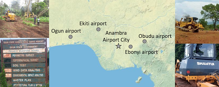
Information about Anambra Airport City/Cargo Airport and its impact on neighbouring communities is a new addition to a cluster of similar airport projects in southern Nigeria, all of which are documented and analyzed in the Map of Airport-Related Injustice and Resistance. Land has been cleared to make way for proposed cargo airports in Ekiti, Ogun, Obudu and Ebonyi. In all four cases bulldozers arrived without warning and began destroying people’s farmland and crops to make way for airport construction.

In the case of the proposed Ekiti airport bulldozers ripped down trees and cleared farmland before even consulting affected farm owners from five villages. Farmers succeeded in stalling the project and secured a major court victory with all their claims against the state government being vindicated. Hundreds of farmers protested against land-grabbing for a cargo airport in Ogun State. In 2018 it was reported that 5,000 farmers were affected by the project and some had been intimidated and their crops bulldozed. Earth moving equipment began destroying farmland and felling trees in three Obudu villages where land has been earmarked for an airport, flouting project planning and land procedures. Allocation of a large land area for a proposed cargo airport in Ebonyi cargo triggered protests by people facing displacement from their ancestral homes and farmland. Bulldozers began clearing land and destroying crops and landowners raised alarm over imminent hunger in their community.

Map of Airport-related Injustice and Resistance, an introduction

Around the world communities are opposing new airports, expansion of existing airports and aerotropolis/airport city developments. A total of 67 cases have now been documented and are published on the Global map of aviation-related socio-environmental conflicts. Several cases and some of the emerging themes are outlined in this short introductory video. The map is a joint project of EnvJustice and the Stay Grounded Network.

Links to airport conflict cases mentioned in video:

Global map of aviation-related socio-environmental conflicts and justice movements

A global map of socio-environmental conflicts and justice movements related to aviation-related projects includes 60 cases that have already been analyzed. The map provides a wealth of information on how people and the environment can be negatively impacted by new airports and expansion of existing airports. Affected communities contend with a multitude of injustices: eviction, land dispossession, loss of farmland and fishing grounds, destruction of ecosystems, construction work impacts and health damage from aircraft pollution and noise once airport projects become operational. More than 300 such cases around the world have been registered in the research project, conducted by the EnvJustice project and the Stay Grounded network.

Global map of aviation-related conflicts and environmental justice movements produced by The EnvJustice project of the Environmental Science and Technology Institute at the Universitat Autònoma de Barcelona (Autonomous University of Barcelona) ICTA-UAB and the Stay Grounded network
Map of aviation-related conflicts and environmental justice movements around the world

Several aerotropolis or airport city projects, i.e. substantial commercial and/or industrial development constructed or planned on land surrounding or adjoining an airport, are documented and analyzed. Examples include Kertajati Airport and New Yogyakarta International Airport in Indonesia, both of which involved forcible eviction of communities from several villages from their homes and farmlands. In Cambodia, the government has approved a plan for a new Phnom Penh Airport, one of the world’s largest airports by land area, along with an associated ‘airport city’. The proposed site, predominantly agricultural land, encompasses land that Kandal Stueng villages have resided on for two decades, including communally held wetlands. About 2,000 families could be affected and hundreds of people have protested against the development.

In India, Andal Aerotropolis is a private airport city development that was stalled by sharecroppers protesting delays in receiving compensation for land taken for the project. Landowners from seven villages in Purandar sustained resistance against loss of their homes and farmland for a new airport since the location of the project was announced in 2016. Then in 2018 it was reported that the state government was forming a consortium to drive investment in an ‘airport city’ around the airport. Villagers’ resistance against displacement from their farmland for Bhogapuram Aerotropolis, also referred to as an ‘aerocity’, succeeded in reducing the land area allocated to the project from 6,000 hectares to 1,122 hectares, along with securing higher compensation for a group of farmers.

A plan for a new airport on the Arial Beel wetlands in Bangladesh is an example of a aerotropolis-type megaproject that was halted by mass mobilisation. A vast swath of land had been earmarked for development, 10,117 hectares for the airport and an accompanying ‘satellite city’, and the farming and fishing livelihoods of thousands of people were set to be seriously affected with wetlands paved over. The government cancelled the project after major protests, the largest of which involved 30,000 people. In the Philippines, mangroves, coastal wetlands providing a vital habitat for many species and protection from erosion and flooding, have already been destroyed to make way for the proposed Bulacan Aerotopolis which threatens to destroy fishing livelihoods. Airport projects can entail deforestation. In Nepal, the proposed Nijgadh Airport, a massive 8,000 hectare aerotropolis, raises the prospect of over 2.4 million trees being felled.

A number of airport projects shown on the map are key components of tourism development schemes that are based upon aviation dependency. A proposed new airport on the Island of Fainu, in The Maldives, is accompanied by a plan for an adjoining hotel. The project would destroy a long stretch of white sand coastline, dense forest and agricultural land, the airport and hotel projects combined swallowing up much of the small island. Another example is the Philippine island of Sicogon where, in the aftermath of the devastation wreaked by Typhoon Yolanda, developers seized upon the opportunity for tourism development, the first phase of which includes an airport specifically for tourism along with beachfront accommodation. Disaster capitalism is also evident in the Caribbean island of Barbuda where land clearance for construction of a new airport, intended to support tourism growth in particular high-end resorts, began shortly after residents were evacuated following Hurricane Irma.

The map includes two major airports built to support fossil fuel projects. Uganda’s second international airport, Hoima Airport, currently under construction, is a key component of the 29 square kilometre Kabaale Petrochemical Industrial Park. With a 3.5 kilometre length runway, capable of accommodating the world’s largest cargo aircraft, it is envisaged that in its first phase of operations Hoima Airport will handle delivery of heavy equipment for the oil refinery on the site. In a similar vein, Komo Airfield, in the southern highlands of Papua New Guinea, has the country’s longest runway and was built for delivery of heavyweight and outsize equipment for the ExxonMobil led PNG LNG (liquefied natural gas) project.

A number of cases shown on the map involve allocation of larger areas of land than would be required for aviation operations, increasing the number of people potentially facing displacement due to land acquisition, but without clear information on what the excess land might be utilized for. For example, in Nigeria the Cross River State government intends to acquire 900 hectares of land for a proposed Obudu International Passenger and Cargo Airport and people have been evicted from their homes and farmlands. In a similar case in Nigeria, bulldozers arrived without warning to clear 4,000 hectares of farmland where crops including cocoa, palm trees and bananas were cultivated for a cargo airport in Ekiti. This airport project is one instance of a successful court case where affected people secured a court victory that halted the airport project. Also in Nigeria, about 5,000 people from 20 villages could be affected by a proposed Ogun cargo airport and hundreds of farmers protested against land-grabbing.

The map of aviation-related conflicts and environmental justice movements is an ongoing project in development coordinated by the EnvJustice (ICTA-UAB) project and the Stay Grounded network. In addition to the 60 airport-related cases already included, a great many further cases have been registered as meriting further investigation. A total of 300 cases have been registered. The information gathered for the global map has been provided by a wide variety of organizations, local collectives and academics. The research team is coordinated by Rose Bridger (Stay Grounded) and Sara Mingorria (ICTA-UAB). This already substantial database and interactive map related to airports is part of Ejatlas, the biggest global inventory of socio-environmental conflicts around the world. As of 11th July 2019 2,831 cases were registered on Ejatlas and this is anticipated to increase to 3,000 cases by the end of the year.

Maps of New Mexico City International Airport (NAICM) and aerotropolis

GAAM is delighted to share an incredibly informative set of maps elucidating the complex socio-economic and environmental impacts of construction of New Mexico City International Airport (NAICM). The maps were produced by GeoComunes, a collective working with communities to use maps as an analytical tool to strengthen the struggle for defence of common goods, in collaboration with affected residents and NGOs supported by Coordinadora de Pueblos y Organizaciones del Oriente del Estado de México (CPOOEM), which supports people’s defence of land, water and culture in eastern Mexico. The NAICM site, covering over 4,431 hectares, is the waterlogged Texcoco lakebed. Aerotropolis development is planned: a specific area within the airport site and commercial and industrial development over an extensive area surrounding it.

NAICM maps

The first map, below, shows uncontrolled urbanization between 2000 and 2015, preceded by highway expansion, driven by real estate and encroaching on ejidos (communally held agricultural land) near the shores of Texcoco Lake. Landfill sites receiving waste from Mexico City have damaged farmland and polluted aquifers. The airport site is in the ‘Zona Federal’ area in the centre of the map. The existing Mexico City International Airport (officially named Benito Juárez International Airport) is shown near the bottom of the map.NAICM map 1

A perimeter fence has been erected around the NAICM Phase 1 project area. The site includes ejidal lands, in spite of assurances that the airport would be built entirely on federally-owned land. Ejidal lands were also appropriated for a highway and housing developments, and many Ejidos (land holders) were violently evicted by state security forces. Plans for Aerotropolis phase 1 include a shopping mall, hotels, industrial park, exclusive high-end housing, golf courses and a free trade zone. NAICM map 2

The third map shows satellite imagery of the three Ejido areas directly affected by airport construction. Over 330 hectares of ejidal lands, in the communities of Ixtapan, Nexquipayac and Atenco, were seized from its rightful owners by the government and now lie within the NAICM perimeter fence.NAICM map 3

Land-levelling to prepare the site for construction of the airport involved clearing saline sludge from the lakebed and toxic waste that has been dumped, polluting the Texcoco aquifer and damaging farmland. Extraction of materials for use in has had a devastating impact on sacred mountains, in the Valley of Mexico. Blasting with dynamite has damaged, forests, biodiversity, springs and archaeological remains. It is estimated that 64 million tonnes of tezontle (red volcanic rock) along with stone and other materials, carried on 400 trucks per day, will be deposited to fill in the Texcoco lakebed.NAICM map 4

Water drained from the Lake Texcoco area will be channelled into Nabo Carrillo, an artificial lake and newly created lagoons, along with water from the area east of the airport site channelled via several culverted rivers. Lying at the bottom of a downward slope the airport site is at risk of flooding from concentration of water flow in this area. The flood risk could become more severe as Texcoco lakebed is sinking at a rate of about 12 inches annually. NAICM map 5

An extensive road network linking NAICM to key urban centres is planned and under construction, encroaching on ejidal land and opening up additional land for real estate and commercial development. Many of the roads are toll roads which will generate profits for construction firms holding the concessions and thus set to benefit from the traffic flow.NAICM map 6

Data from all the maps is combined in the final map, which covers a wider geographical area revealing the extent of the urbanization that is underway and planned. See the larger version of the map for more detail. NAICM is shown within a wider context as the most important of, and the focal point for, a series of megaprojects combining to form a ‘Megalopolis’, an agglomeration of cities and other urban areas. New road and rail corridors will foster further real estate development. Mexico City already suffers chronic water shortages and springs and groundwater are over-exploited. The current model of urbanization will increase stress on water supplies and aqueducts are planned to access more distant sources.  NAICM map 7 s

All the maps of NAICM and aerotropolis plans can be seen here in their entirety and are best viewed on the largest computer screen that you can find so you can zoom in and see the intricate detail.