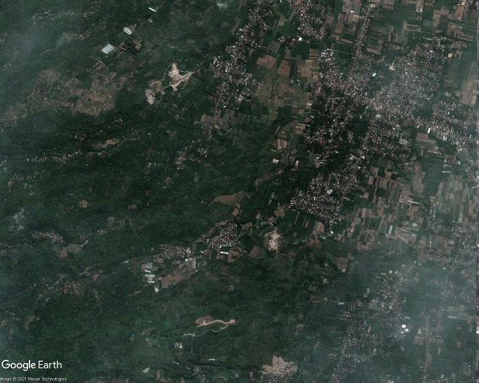
Guwahati Airport and the villages of Azara, Garal and Mirzapur. Satellite imagery: 03/04/2024
A land acquisition notice for a proposed Aerotropolis near Guwahati Airport – the primary airport of northeast India located in the west of Assams’ largest city and also known as Lokpriya Gopinath Bordoloi International Airport (LGBI) – met with anxiety, anger and opposition from many affected residents. Issued on 25th July 2025 by the Kamrup Metropolitan District Administration the notice encompassed 400 bighas (101 hectares) of inhabited and uninhabited land in the villages of Azara, Garal and Mirzapur and impact upon more than a thousand families. Many villagers had given land for construction of Guwahati Airport decades ago and feared loss of their homes and livelihoods. An Azara resident said, “We have already given away vast stretches of land. Now this fresh move will leave many of us homeless.” In Garal village, where the district administration moved to acquire 70 bighas (17.7 hectares) of land for the Aerotropolis project, over 100 pattadars (landholders) were named in the land acquisition notice. Critics of the project claimed the land acquisition process lacked transparency, consultation or a clear plan to rehabilitate affected people and that the main beneficiary would be a private company. Guwahati Airport is owned by Adani, one of India’s largest multinational conglomerates. A local committee member said, “Guwahati Airport is now under Adani’s ownership. So the land being acquired in the name of an airport township will ultimately go to Adani.”
Affected families began to protest the land acquisition process, demanding transparency, a thorough impact assessment and guarantees that they would be rehabilitated. “We are not against development”, said an affected farmer, “But we deserve clarity, transparency and fair compensation. Right now everything feels juggled up and a lot is hidden from the public.” Protests took place in many affected areas. Leader of the Opposition Debabrata Saikia described the move to acquire land for the ‘Aerocity‘ as anti-indigenous and serving corporate interests. He said more than 1,116 families were affected, some of which had held land titles for nearly 200 years. He also warned that, in addition to the families facing displacement, local entrepreneurs in the area running guesthouses and restaurants would be adversely impacted. The location of the project site, near the Deepor Beel freshwater lake, a Ramsar site (designated as of international importance under the Ramsar Convention) raised environmental concerns.
Land acquisition for the aerotropolis had been requested by the managing director of the Assam Industrial Development Corporation (AIDC). Akan Chandra Das, president of Mirzapur Anchalik Bhumi Suraksha Samiti, the committee representing affected residents of Mirzapur, Azara and Garal villages, said, “Already nine to ten times, our families gave land to the government post-independence, for development of the airport, adjacent roads, and defence establishments near the Guwahati airport. If the remaining land is also taken for development projects, where will we go? How will our children survive if they don’t get jobs in other sectors?” Basudev Mali, a retired teacher and owner of 10 bighas (2.53 hectares) of land near the airport, in Mirzapur, said, “If the government continues to take over our lands for airport expansion or for aerotropolis development now, who will ensure the survival of our children? The remaining farmlands were our only hope, but the government wants to take that also.”
A residents’ delegation met with Chief Minister Himanta Biswa Samra, but his attempts to reassure them that only vacant land would be used, for public projects were unsuccessful. Locals remained reluctant to give up their land for either government or private projects. Villagers attending a public meeting in Mirzapur unanimously resolved not to give their land to the government under any circumstances, declaring, “Our land is our identity and livelihood. We will not give it away at any cost.” At the beginning of September 2025 the Guwahati Metropolitan Development Authority (GMDA) suspended building permits and land sales in the proposed aerotropolis area around Guwahati Airport. Additional restrictions were also imposed. The suspension affected Azara, Garal and Mirzapur villages where hundreds of indigenous families were unwilling to vacate their land for the aerotropolis project. They also opposed the notice issued by GMDA as it restricted their rights as landowners.
Construction of Africa’s biggest airport, a Mega Airport City, in Bishoftu, Ethiopia, is set to take up a vast 35 square kilometre site and a budget of USD6 billion just for the first phase and has met with resistance from farmers impacted by the resettlementprocess.
Artist rendering of planned Mega Airport City in Bishoftu, Ethiopia. Photo: Ethiopian Airlines, September 2024
Ethiopian Airlines announced plans for an airport city in Abusera (in Bishoftu, part of central Ethiopia’s Oromia region, about 40 kilometres southeast of Addis Ababa) in September 2018. CEO Tewolde Gebremariam said the location was selected because of its elevation; at about 1,900 metres above sea level it is considerably lower than Addis Ababa at 2,400 metres. This would bring the advantage of improved fuel efficiency for flights in comparison with Ethiopia’s existing main airport, Addis Ababa Bole International Airport. French engineering firm ADP Ingénierie (ADPI) conducted a site selection study and in February 2019 the Council of Ministers was set to endorse the proposed site in Abusera. Gebremariam said the mega-hub would not just be an airport, costing USD4 billion with four runways and capacity to handle 80 million passengers per year; it would include other infrastructures making it an airport city with a large duty-free shopping area, entertainment centres, hotels, business centre, logistics centres and real estate development. By January 2020 the airport city plans had become even more ambitious; passenger capacity had increased to 100 million per year. The anticipated cost had also risen significantly. Gebremariam said “We have identified 35sqkm land to be developed as an airport and it is about a $5bn project – larger than the Grand Ethiopian Renaissance Dam (GERD). It is going to accommodate 100m passengers; larger than Dubai and more or less equal to the new Istanbul airport.”
In February 2024 Ethiopian Airlines announced that the designated land for the airport city had been secured and that the project would encompass an area of 38 to 40 square kilometres. A spokesperson said the Oromia Regional Government, in collaboration with the Federal Government, was evacuating residents from the site to make way for construction to begin. The estimated cost of the megaproject had escalated again. In August 2024 Ethiopian Airlines was searching for USD6 billion in financing just for the first phase of what was now called a ‘Mega Airport City’. Projected passenger capacity increased again, to 110 million per annum, and the Dar Al-Handasah consultancy was awarded the contract for design and supervision of the Mega Airport City. At the signing ceremony Ethiopian Airlines stated, ‘The architectural team will incorporate elements of Ethiopian heritage to establish a people-centric, intuitive airport characterised by sustainability, resilience, and future-readiness.’
The claim to be ‘intuitive airport’, ascribing sentience to infrastructure, is just meaningless corporate guff. And the claims to be ‘people-centric’ boasting the qualities of ‘sustainability’, ‘resilience’ and ‘future-readiness’ disregard the airport city’s impacts on the people most directly affected, those who are being displaced to make way for it. Simultaneous with the search for USD6 billion to finance the airport city it was announced that construction could only go ahead if up to 2,500 farmers currently residing on and surrounding the site were resettled. Mesfin Tassev, CEO of Dar Al-Handasah, said a 740-hectare plot had been allocated by the Oromia Regional Government for this purpose, along with 17 billion Birr (USD172.5 million) for resettlement and development works. Design work was anticipated to be complete by December 2025 followed by construction of housing and other basic facilities along with development of employment opportunities for relocated residents by the end of 2026. Mesfin told The Reporter, “The construction of the airport city depends on the resettlement of the farmers. It will commence as soon as they move.”
The resettlement process is not proceeding smoothly. By January 2025 it was reported that Africa’s biggest airport was under construction but ‘faced significant challenges’ regarding coordination of finances, geopolitical dynamics, environmental concerns and the complex task of relocating affected communities. The airport city has triggered local resistance. Affected farmers, many of whom depend upon their land for subsistence and farming livelihoods, are concerned about compensation and resettlement. Many of them feel inadequately compensated and there are reports that the compensation offer was far less than the land’s market value. Resettlement has also caused discontent. Some farmers claim that clear plans for relocation and support for finding new livelihoods have not been provided. During a local meeting held to discuss the project one farmer said, “I’ve cultivated this land for decades. It’s not just my home. It’s my history and my family’s future.”
Satellite image of Lucknow Airport (Chaudhary Charan Singh International Airport) dated 20/10/2024. Location of Terminal 3 and some of the villages affected by land acquisition for airport expansion are shown.
Lucknow Airport (also known as Chaudhary Charan Singh International Airport), located 14km southwest of the capital city of Uttar Pradesh, is already the 11th busiest airport in India and traffic will increase with recent and ongoing expansion. A third terminal began operations on 30th March 2024, with capacity for 8 million passengers per year, set to rise to about 13 million upon completion of phase two. Land from Bhaktikhera village was used for the third terminal and runway extension and in March 2018 the Airports Authority of India (AAI) agreed to pay Rs 32 crore for relocation of about 600 residents. Compensation for acquisition of 70 acres of land from Bhaktikhera, Gurera and Aurangabad Jagir villages, for runway extension and other facilities, was still being negotiated in June 2018. Airport expansion had been stalled for a decade due to difficulties with land acquisition. But in June 2019 the AAI announced that ‘decks are cleared for the construction of the wall around the airport and expansion of the runway’. The district administration committed to helping AAI build the wall to keep out people ‘trespassing the area’ and stray animals posing safety risks.
Demolition notices and farmers protest boundary wall construction
Construction of houses near Lucknow Airport also raised safety concerns. At the end of August 2024 authorities served demolition notices on 50 houses which had been built next to the airport boundary without authorization. A Lucknow Development Authority (LDA) official said a builder had posed as a contractor without obtaining the requisite No Objection Certificate (NOC) from the airport administration, acquired land directly from farmers and pocketed the money. A month later construction of the airport boundary wall led to a clash between a group of farmers and police. After commencement of excavations works, with two JCBs in the presence of police, a large number of farmers, between 150 and 200, gathered and began to protest, saying the airport administration was forcibly occupying their land. The farmers, from Rahimabad and Mohammadpur Bhakti Kheda villages, said a disputed land petition was pending adjudication in the Allahabad High Court. The protest forced authorities to temporarily halt land reclamation operations for airport expansion. Farmers argued that the land had been cultivated for many generations and that land acquisition notification in the 1950s lacked important details including plot numbers, land area and the names of the landowners, thus raising questions about the legitimacy of the acquisition process.
In response to the protest the district administration postponed the land reclamation drive until 15th October. The owner and operator of Lucknow Airport, Adani, one of India’s largest multinational conglomerates, plans to reclaim approximately 260 acres on the southern edge of the airport for extension of the runway to 3,500 metres to accommodate large, wide-body aircraft and construction of two parallel taxiways. Speaking anonymously, an official stated that a total of about 400 acres owned by the airport for over 70 years would be reclaimed for airport expansion and a survey would be conducted to compensate farmers with crops growing on the land. The principal petitioner against the land reclamation said the farmland had not been legally acquired, farmers had not received any compensation and Adani was attempting to forcibly construct the airport boundary wall.
Boundary wall construction continues and Aero City plans
On 25th October the Supreme Court dismissed the farmers’ plea against expansion of Lucknow Airport, allowing LDA to proceed with the project. Lucknow Development Index announced on X that, after deployment of a ‘heavy police force’ in response to resistance, ‘work is still progressing amid farmers clashes’. A ‘massive area’ was being reclaimed and construction of the boundary wall had re-commenced. An official source said a 400-acre area was being reclaimed and a fourth terminal and an Aero City was planned on the land.
Few months previously, on 5th February 2024 Times of India had reported ‘ambitious plans’ for Lucknow Aerocity, a 1,500 acre development with ‘an array of upscale amenities, such as world-class convention centres, large parks and seven-star hotels’, announced by Uttar Pradesh finance minister Suresh Kharna. The LDA was tasked with identifying land for the project, likely to be located in Rahimabad and Gahru villages. In addition to Lucknow, Adani owns several airports in India including Mumbai, Mangaluru, Jaipur, Ahemedabad, Thiruvanthapuram and Guwahati. Plans for aero cities adjoining Adani’s airports were reported in July 2022. The Economic Times stated that Adani plans to develop ‘aero cities’ on more than 500 acres at all its airports, with hotels, convention centres, retail, entertainment, healthcare, logistics, offices and other real estate sectors.
Locals resisted eviction for Guwahati Airport expansion
At the beginning of September 2021, a month before operation of Guwahati Airport (the busiest airport in northeast India) was handed over to Adani, there were reports of locals resisting eviction to make way for expansion. An eviction notice was served to 54 households, outside the walled area of the airport in Koitasidhi village. An airport official said the land, adjacent to the runway, was to be developed as an approach area, especially for larger aircraft on international flights. Villagers said that several plots of land had been acquired for construction and expansion of the airport since 1962. Some villagers said, “We would rather give our blood than give up our land”. Continuing protest was reported on 8th September; a local person said “We heard that the Adani group which has been given charge of the Airport for 50 years under a lease agreement by the Government of India wants to do expansion work here. But we want to clarify that we will not leave our land even if we are given adequate compensation”. Some other locals said they would not give their land to Adani. On 15th September 2021 the Times of India reported that villagers were fiercely resisting giving up land for airport expansion. A tearful farmer in his late 70s said his family had been compelled to give up land for airport expansion in the 1960s, which if sold today would fetch a much higher price. His family was left with ownership of just one residential plot. More recently, in June 2024, announcing the schedule for opening of a new terminal at Guwahati Airport in April 2025, Chief Airport Officer Utpal Baruah said plans for subsequent expansion phases included a maintenance, repair and overhaul (MRO) facility, aerocity and helipad.
Gelephu Airport, one of only four airports in Bhutan, is a domestic airport located in the southern Himalayan foothills, close to the Indian border. In August 2023, as formulation of the master plan for expansion of Gelephu Airport neared completion and groundwork preparations began, there was growing speculation among landowners with properties in the proposed site regarding replacement land and compensation. Acquisition of land was to be determined by the government. The groundbreaking ceremony for Gelephu International Airport took place on 23rd December 2023. Satelite imagery dated 1st January 2024 reveals a large area of low-lying scrub land has been cleared for the airport expansion.
Satellite imagery shows clearance of a large area of low-lying scrubland for expansion of Gelephu Airport, including the new runway, and construction of a dry port south of the existing runway.
Expansion of Gelephu Airport is a key component of an even larger megaproject, a new city, and some residents are concered about losing land to the project. On 15th December 2023 Forbes reported that King Jigme Khesar Namgyel Wangchuck would be announcing development of a new ‘megacity’ in Gelephu, called Bhutan Mindfulness City, on Bhutan’s National Day, the 17th December. Initially there were plans for the announcement to take place in Gelephu, but the town, with just 10,000 residents, lacked the requisite infrastructure such as accommodation for international guests so the event was relocated to the capital city, Thimpu. Ahead of the official announcement the article cautioned that the new city project might be met with ‘strong opposition from Bhutan’s nearly 800,000 citizens’ and that ‘fears of government land grabs and the displacement of farmers in Gelephu have already taken root, according to several Bhutanese residents’. Sources with knowledge of Mindfulness City said the King was ‘trying to avoid the preception that families will be forcibly transferred to make way for the project’.
Mindfulness City was indeed the focus of the King’s 116th National Day address. The Bhutanese reported the King’s description of the new city, explaining that it will cover 1,000 square kilometres, about 2.5% of Bhutan’s total land area. Major public investment in roads, bridges and airports is planned, with an inflow of foreign investment anticipated for construction of offices, residencies, schools, hospitals, shops, hotels and restaurants. The new city was also referred to as Gelephu Special Administrative Region (SAR), an ‘economic hub’ that will have ‘autonomy to formulate laws and policies’. Ten of the twelve gewogs (groups of villages) in the Sarpang Dzongkhag (District) – Tareythang, Umling, Chhuzagang, Serzhong, Gelephu, Samtenling, Dekiling, Shompangkha, Gakiling, and Singye – were designated for the Gelephu Mindfulness City project. Kuensel Online reported that residents and landlords were ‘excited about the the upcoming development initiative’, attributing some landlords’ anxiety and fear of losing all of their land to the project to ‘lack of awareness regarding private properties’. There was reassurance of compensation following international practices and provision of replacement land in the city area. It appeared that acquisition of private land would be limited to areas allocated for road and airport construction.
Danish architecture firm BIG, known as a masterplanner for other megaprojects such as Neom, a glass-walled linear city in Saudi Arabia, duly unveiled its masterplan for Mindfulness City, including an international airport. Connectivity was a recurring theme of BIG founder Bjarke Ingels’ description of the new city; he said “Gelephu becomes a land of bridges, connecting nature and people, past and future, local and global”. Apparently, the project will ‘be shaped by 35 rivers and streams that run through the site’. Neighbourhoods will be connected by several ‘inhabitable bridges’ hosting facilities including a university, a healthcare centre and a spiritual centre. Connectivity claims extended to the airport, its timber terminal to act as a bridge. But its runway, crossing over several rivers, while facilitating connectivity for global air travellers, will cause major disruption to hydrological systems. And how does a new city highly dependent on fossil-fuel dependent international air travel square with the Gelephu Mindfulness City website claim of ‘Sustainability as a carbon negative country’? Buildings will incorporate local materials and be ‘informed by Bhutanese architecture‘. But will techniques and structures resonating with local cultural identity be integral to the function of new buildings, or merely aesthetically pleasing adornments? Perhaps the most striking showpiece feature of Mindulness City is the plan for a hydro-electric dam containing a temple. Will the new city be, as Ingels said, “founded on Bhutanese nature and culture”, or merely garnished with it?
A 6th January 2024 Kuensel Online article stated that that Gelephu Mindfulness City would commence with expansion of Gelephu Airport and landowners with land in the area earmarked for the airport had been given replacement land or compensation. Landlords confused about the future of their holdings had been told that they had ‘nothing to worry about’ as the project would include everyone and leave nobody behind, indeed ‘the entire Bhutanese citizenry would be part of the historic project’. This claim of inclusivity is at odds with the Gelephu Mindfulness City website promotion of new city aiming to ‘attract global top talents who are global and creative’ and ‘serve as a hub of global top minds’, i.e. for an international elite. By February 2024 six JCBs had cleared about 1,800 acres of land, working towards the goal of clearing 2,500 acres. Just south of the airport, a dry port was under construction. After considering three models for the airport expansion officials had selected the Asian Development Bank (ADB) masterplan. A new runway next to the existing runway will be 3km in length; possible extension of the runway to 3.5km to accommodate the Airbus A380 would cross over two rivers. Building a new runway will allow continuation of airport operations using the existing runway, enabling visitors involved in the development of Mindfulness City to fly in and out. The initial cost estimate of the ADB masterplan was Nu 8 billion (USD96 million) but a more recent estimate by the Airport Authority of India indicated a far higher figure, possibly as high as Nu 20 billion (USD240 million).
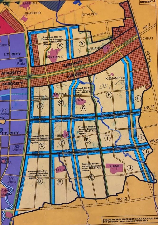
A study focussing on three villages affected by land acquisition for expansion Mohali Aero City, southwest of Shaheed Bhagat Singh International Airport, raised concerns over threats to rural livelihoods.
Proposed acquisition of 5,438 acres (2,200 hectares) of land from 14 villages – Bakarpur, Naraingarh, Kishanpura, Safipur, Rurka, Matran, Bari, Chatt, Saini Majra, Seon, Kurari, Chau Majra, Manauli and Paton – for AeroCity expansion, called ‘Aerotropolis’, was confirmed by Greater Mohali Area Development Authority (GMADA) in 2017. A 2021 article in the Journal of Land and Rural Studies by Thomas Reuter, Sarbjeet Singh, A.K. Sinha and Shalina Mehta, Land Grab Practices and a Threat to Livelihood and Food Security in India? A Case Study from Aerocity Expansion Project from S.A.S. Nagar, Punjab, analyses the project as an example of large-scale acquisition of highly fertile agricultural land. The authors describe ‘blatant land grab practices by the state authority in the name of development, which act as barriers to the food security and threaten the livelihoods of those whose land will be acquired’. The study focussed on three affected villages – Patton, Kurari and Seon. Fieldwork conducted in April 2019 included in-depth interviews with 50 displaced farmers.
A consolidated demographic profile of Patton, Kurari and Seon from the 2011 census showed that the total number of affected people was 3,031. A significant number, 955, belonged to the scheduled caste population, the most marginal rural people, many of them landless labourers, some of whom farm on leased land and other providing menial services. Land acquisition renders them homeless and they receive no compensation. The scheduled caste community of Patton village were marginal farmers owning only 1-2 acres of land. Scheduled caste people of Kurari and Seon did not own any land and depended entirely on agricultural activities. The working population was divided into two categories. ‘Main workers’ included marginalised individuals regularly hired by affluent farmers to work in their fields and people engaged in pastoral activities in a more favourable economic situation. ‘Marginal workers’ comprised migrant workers primarily from Uttar Pradesh and Bihar along with seasonal workers from other states coming to the area for work harvesting paddy and wheat. Agriculture was the primary economic activity in the three villages. Several farmers had modern equipment such as tractors, tillers and adequate irrigation with tube wells for which free electricity was provided by the state. Farmers getting cash compensation for surrendered land tend to lose these subsidies, along with minimum price support for cereal crops.
Narratives from three affected farmers
The article includes narratives from three farmers affected by land acquisition for the Aero City Expansion. A 59-year old man from Kurari village grieved that the pace of urbanisation would convert lush green fields into a concrete jungle. He worried that wheat, rice, maize and other cereal crops would disappear. GMADA and private builders offered different compensation packages, causing friction among those surrendering prime agricultural land and also between farmers and the state, resulting in litigations and delays in land acquisition and launch of construction activities. A respondent from Patton said that a decade ago the land was unsuitable for farming and nobody wanted to settle in the village. Residents worked hard and within two years had made all the available land suitable for agriculture. Most farmers grew vegetables and cereals which they sold at nearby farmers’ markets. When GMADA notified the village for land acquisition for the Aero City Expansion project farmers feared compulsory acquisition and sold their land to private builders. He said that when the government acquires land compensation is inadequate and the payment process often gets trapped in legislation. He had worked hard on the land he was forced to sell and was unsure of the productive capacity of new land he had purchased. A Seon villager whose land was acquired by GMADA for the Aero City Expansion had not been paid adequate compensation. He retained six acres but there was a possibility this would also fall under the proposed land acquisition, leaving him without any means of livelihood.
Loss of pastoral activities and social stability
Livestock provided an important subsidiary source of income in the three villages. Cows and buffalo were reared mainly for milk and cows also for manure. Pastoral activities in the three villages were mainly pursued by women waking up early to milk cows and buffalo. Land acquisition can deprive women of this primary economic activity making them far more vulnerable, especially when they run single-parent households. The case studies suggested that animal rearing as a livelihood became unviable because land used for pasture was no longer in villagers’ possession. Loss of agricultural land can cause cessation of pastoral activities, as most displaced households are not compensated with sufficient land to accommodate dairy animals.
Residents of the villages were content with acquisition of small portions of land along roads as it brought them improved connectivity. But acquisition of their fertile land for development of housing for wealthy urbanites and creation of infrastructure in which they were not equal stakeholders left locals feeling cheated. Their lives were marked with upheavals and displacement threatened close-knit social networks. The authors conclude that the Aero City Expansion project was ‘an ambitious ideas but executed without due diligence and groundwork’. Land acquisition brought revenue to the state but measures to support the interests of local residents were inadequate. Urban planners failed to foresee the risks of social tensions and the Aero City epxansion led to social and political instability. The article warned of agricultural decline and the prospect of food insecurity.
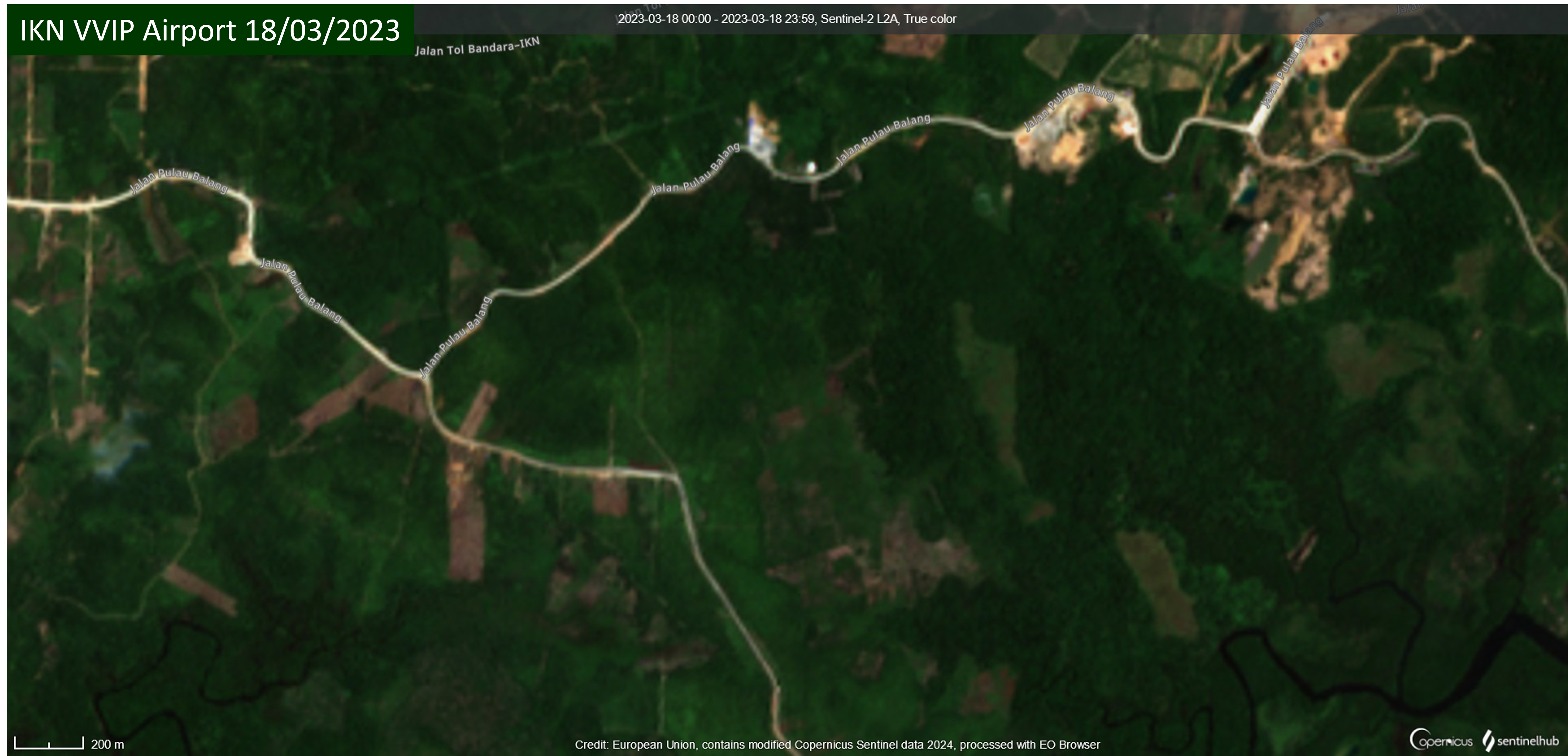
In East Kalimantan on the east coast of Borneo a new VVIP (Very Very Important Person) airport is being constructed to support development of Nusantara (IKN), the future capital city of Indonesia. With a VVIP and VIP terminal covering an area of 7,350 square metres and three helipads IKN VVIP Airport will support the mobility of the President, high-ranking officials, state guests and investors. The international airport will have a 3,000 metre runway to accommodate Airbus A400 military airaft and will be used in coordination with the Indonesian Air Force (IAF). Development of IKN VVIP Airport was accelerated by Presidential Regulation No. 31 on 6th June 2023.
Satellite imagery shows land clearance and earthworks. The image on the left is from 18th March 2023 before works began. On the right is an image from 16th February 2024 where development of the IKN VVIP Airport terminal, runway and access road are clearly visible.
Demarcation of a 360-hectare site began within a few days and triggered reaction from some affected residents. On 30th June Muslimah News reported that hundreds of residents from five sub-districts – Gersik, Jenebora, Pantai Lango, Kelurahan Riko and the Maridan village area in Sepaku – were protesting take-over of land they occupied by the Land Bank Agency for construction of the VVIP airport. They refused to hand over their land to the Land Bank Agency because stakes were installed without prior notice and the government’s promise, made the previous year, to provide land for agrarian reform had not yet been fulfilled. There was a lot of evidence that construction was consuming residents’ land and authorities were ignoring their protests. Protest was not just in response to construction of the airport; there was also some controversy over whether the land bank serves public interest or corporate projects. The Land Bank Agency made reassurances that residents’ rights to replacement land would be accelerated and that agrarian reform land was being prepared for this purpose.
On 3rd August 2023 many palm farmers gathered at their former plantation area where they unfurled banners and made speeches demanding compensation for land affected by the VVIP airport construction project. A lawyer representing some of the residents said that oil palm land previously managed by them was suddenly cleared with heavy equipment. Palm oil trees had been damaged and razed to the ground but the farmers said they had not received compensation and there had been no discussions or meetings with authorities.
Land clearance and installation of boundary markers continued and on 10th January 2024, during socialisation for communities impacted by construction of the VVIP airport and access toll road, it was announced that 400 hectares of replacement land had been prepared for them. Yet complaints about the land acquisition process continued. On 14th January 2024 TribunKaltim reported that some farmers whose land was used for construction of the VVIP airport were unable to farm the land and had no clarity regarding replacement land. The land declared for the airport was the only land they owned and they relied upon it for their livelihoods. Many affected farmers owned one or two hectares of land. Many residents who lost their land had still not received compensation.
On 9th February 2024 Acting Regent of North Penajam Paser, Makmur Marbun, said the number of people whose land was allocated for the VVIP airport but had not yet been acquired had reduced from 80 to 22, explaining that the land of these 22 people is in the area that will be the runway and vital for the airport project. The residents had brought a lawyer to the airport site where they met with officials but Makmur Marbun said he would continue to attempt to resolve the issue through discussions. Completion of IKN VVIP Airport and commencement of operations is targeted for early August 2024.
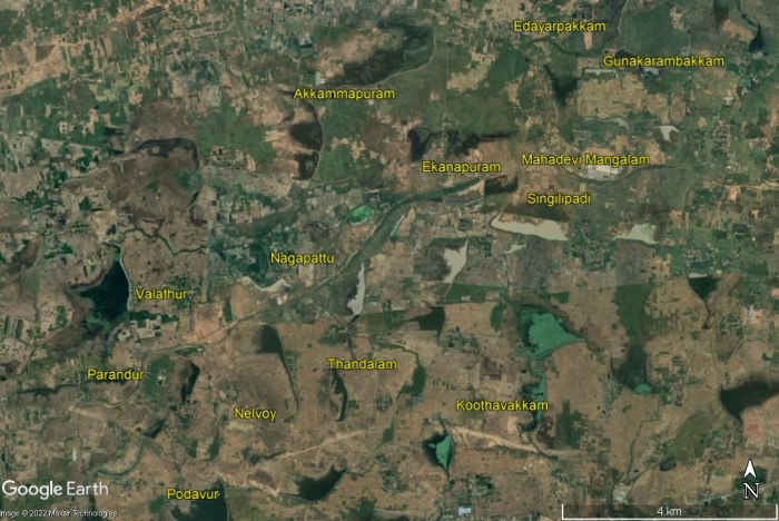
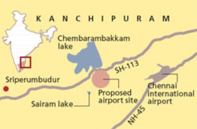
Thousands of farmers and residents have urged the Tamil Nadu state government and Central government of India not to implement a proposed second Chennai airport in Parandur that would destroy their agrarian activities and livelihoods. Parandur is an agricultural area in the Kanchipuram district and the State government plans to acquire land in 12 villages for the airport project. The proposed site in Purandur is approximately 57 kilometres eastwards of the existing Chennai Airport and to the north of the Chennai-Bangalore national highway which is being constructed in stages. Below is a slideshow of a map of the proposed airport site and Google Earth satellite imagery showing several of the villages that might be impacted by land acquisition.
A Times of India article states that the 12 villages from which land for the airport will be acquired are: Parandur, Valathur, Nelvoy, Thandalam, Polavur (Podavur), Madapuram, Ekanapuram, Akkammapuram, Singilipadi, Mahadevi Mangalam, Gunakarambakkam and Edayarpakkam. Other villages to be impacted by land acquisition are listed in other sources referenced in this blogpost, namely Nagapattu, Koothavakkam, Uthyarpakkam and OM Mangalam.
Concerns over acquisition of farmland and environmental issues
On 1st August Union Minister of State for Civil Aviation Vijay Kumar Singh announced that the Parandur site has been finalised after consultation with the Tamil Nadu government. Some Purandar residents demanded suitable replacement land and employment from the government in return for acquiring their land; others said that acquisition of their agricultural land will render them jobless as it is the only work they have known. Some villagers have spoken to media outlets about reluctance to give up their land and uncertainty over provision of compensation:
Ramasamy, from Ekanpuram village, said “A huge tract of our agricultural land would come under this project. We don’t want to lose our agricultural land for this project because farming is our sole source of livelihood.”
Jayakumar, a farmer from Singilipadi, said, “We have been living here for generations. We didn’t know that the airport is coming up here. No one has informed us. If the government suddenly takes away our homes and land, what would we do? Even if they provide compensation, we don’t know what that would be. I am shocked.”
Rajendran, a resident of Thandalam, said, “We are ready to give up land if needed. But we need assurance from the government about good compensation and employment.
Selvaraj from Parandur village said, “We’ve been here in the village for the last 50 years. As per the map released by the government, 5 villages would be destroyed for constructing a new airport. Even if the government gave us compensation for our land, we don’t know what to do for a living, since we know only farming. All of us are shocked by this decision and are planning for a big protest soon. Even last month, the district collector assured us that the airport would not be constructed in Parandur.”
Nachiyappan, a farmer from Koothavakkam, said, ”We are living by farming and if the government acquires our land what will we do for a living? I have small children and want to educate them and am the sole breadwinner for the family. The government will make all sweet talking, but in reality, nothing will happen and we will be the losers. We will protest strongly against this project that will destroy our livelihood as well as the flora and fauna of the area.”
A postgraduate in Economics from Koothavakkam, R. Bindu, said, “Around 800 houses would be demolished in the area and the agrarian economy will be totally destroyed. There are many people in this village who don’t have the patta or the legal rights of the land and they will be totally on the streets.”
Many villagers are employed by the Mahatma Gandhi National Rural Employment Guarantee Scheme (MNREGS) and are concerned that their livelihoods could be destroyed along with the agricultural fields.
An environmental expert pointed out several hydrological problems that might arise from construction of the airport, from decreased recharge of groundwater to deterioration of water quality and possible flooding during the monsoon. The 4,791-acre site is dotted with water bodies and a large proportion, 2,605 acres, is wetlands. A large number of migratory bird species, especially from eastern Europe, visit the site. Some of the birds fly south to Vedanthangal which would pose a bird strike risk to air traffic. Building a stable structure on wetlands would be challenging. Parandur has a lake where migrant birds – tufted ducks, flamingos and common pochards – are frequently spotted.
An airport on a 4,791-acre site, with a huge aerocity
The proposal is for the new airport, with two runways, to have capacity to handle 100 million passengers annually, almost five times higher than the capacity of the existing Chennai Airport, at 22 million passengers per year. Capacity at Chennai Airport is being increased to 35 million in a seven-year expansion project. The runways at the airport in Purandar would be larger than at Chennai Airport, enabling it to handle larger aircraft carrying more than 600 passengers. Tamil Nadu chief minister Muthuvel Karunanidhi Stalin said the initial estimated cost of the proposed airport is Rs20,000 Crore, more than USD2.5 billion. Details of the break-up of this sum, and the funding route, have yet to be made public.
A Times of India article states that ‘The plan is to develop a huge aero city with facilities for maintenance and repairs, aviation ancillary units, and commercial establishments’. Confederation of Indian Industry (CII) Tamil Nadu Chapter chairman Satyakam Arya has pushed for an aerocity around the new airport, which in addition to aviation related facilities could have a convention centre for global conferences and exhibitions. Shankar Vanavarayar, vice-chairman of CII Tamil Nadu, said the state may introduce special schemes and incentives for industries in order to spur industrialization from Chennai towards Parandur.
The proposed site for the Parandur airport, 4,791 acres (1,939 hectares), is certainly large enough to allocate a significant portion of the site for non-aviation facilities. It is larger than the world’s largest airport, Hartsfield Jackson in Atlanta USA, which, with five parallel runways and a site of 1,902 hectares, handled more than 110.5 million passengers in 2019, before traffic reduced worldwide due to the response to Covid-19. In addition to the 4,791-acre site a further 200 acres of land is required for construction of two airstrips, for which the process of surveys and land acquisition is likely to start soon.
Difficulties acquiring thousands of acres for the airport
Land availability has been the main hurdle stalling the second Chennai airport project since it was first mooted, in 1998. Many attempts at large-scale land acquisition failed until authorities zeroed in on Parandur and an article in The Hindu provides a timeline. In November 2000 a ‘futuristic terminal’ was anticipated on a 3,000-acre site likely to be at Porur in west Meenambakkam, north of the existing Chennai Airport. In May 2007 the then Chief Minister of Tamil Nadu, Muthuvel Karunanidhi, said that 4,820 acres would be acquired for the airport in Sriperumbudur. In 2016 the proposed greenfield airport, still planned in the vicinity of Sriperumbudur, was mired in land procurement problems. Union Minister of State for Civil Aviation Jayant Sinha said the thousands of acres required for the new airport were difficult to procure.
In January 2022 the Airports Authority of India (AAI) began to study four potential alternative sites identified by the State government: Pannur, Parandur, Padalam and Thiruporur. Subsequently this list was narrowed down to Pannur and Parandur. On 1st August 2022 Minister of State for Civil Aviation Vijay Kumar Singh said the Tamil Nadu government had shortlisted Parandur as the site for development of a second Chennai airport. The State government will now submit a proposal to the Ministry of Civil Aviation for ‘grant of site clearance’ for the finalised site. The State is also set to begin preparation of a detailed project report. Land acquisition is likely to begin once the State receives approval from the Centre. State government officials have confirmed they will conduct sittings in all affected villages allowing people to express their views to officials.
2010 protest against land acquisition in Sriperumbudur
The article with the project timeline in The Hindu does not mention that the 2007 identification of land for the airport in Sriperumbudur triggered mass protest by villagers resisting land acquisition. In 2010 Moverment against SEZs in Tamil Nadu reported that a 6,921-acre (2,800-hectare) site in Sriperumbudur, located eastward of Parandur and just 30 kilometres from Chennai’s existing airport, had been earmarked for a greenfield airport. The proposed land acquisition for the new airport threatened to displace 2,800 families, about 37,000 people, from 20 villages. Village representatives opposed the airport project and were not interested in compensation from the government. They said agriculture was viable in the proposed site where they cultivated rice paddies, mangos, jasmine trees and vegetables. The site also containing 77 lakes, 120 ponds and 10,000 trees which would be felled. Six village panchayats – Thirumanaikuppam, Vadamangalam, Vayalur, Thirupandiyur, Kottaiyur and Kiloy – passed resolutions opposing land acquisition in a gram sabha meeting.
Proposed site for a 2nd Chennai airport in Sriperumbudur, triggering mass protest in August 2010. Image: Down to Earth, 15/09/2010
Villagers drove away officials sent to survey the land on at least three occasions. On 12 August 2010, 3,000 people from 26 villages demonstrated against the project. Police attacked them with a lathi (baton) charge. Villagers who went to meet the District Officer and attempted to present a petition were beaten and around 20 of them had to be admitted to hospital. A jet fuel pipeline to Chennai Airport, routed through Sriperumbudur, seemingly hardwired the area for development of a new airport. Inaugurating the fuel pipeline in 2009 Praful Patel, Minister of State for Civil Aviation from 2004 to 2011, said, “This (pipeline) also passes through Sriperumbudur where another airport is planned. Once it comes up, the pipeline will be extremely useful.”
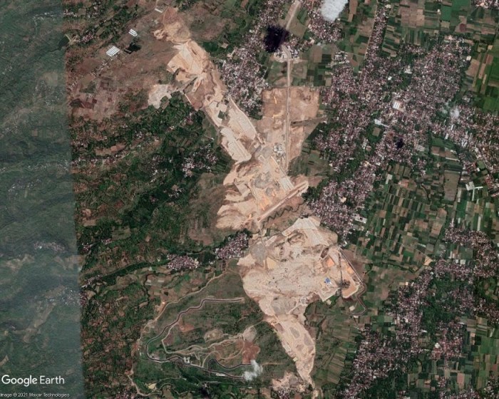
In the early days of the Covid-19 pandemic, on 15th April 2020, officials from the Indonesian government and the East Java province attended a virtual groundbreaking ceremony for a new airport in the Kediri regency. The event marked the official start of construction works that had actually begun three months earlier in January when heavy machines were levelling soil, following several delays that were partly caused by some affected residents refusing to release their land for the project due to unpaid compensation. Fewer than 20 families, in the villages of Bedreck and Bulusari, remained in the area. A villager told The Jakarta Post “If we accept the price, we won’t be able to buy land and build a house of similar value to what we have now”. She said none of the villagers wished to hamper development of the airport, they simply wanted fair compensation. The Kediri administration said that only 0.6 per cent of the 400 hectares of land required to build the airport had not been acquired.
Kediri Airport site area, April 2018
Kediri Airport site area, satellite imagery, June 2020
Kediri Airport site area, satellite imagery, November 2020
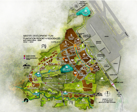
The Kediri Airport project (also referred to as Dhoho Airport) was approved in 2018. The first of the satellite images above shows the airport site area in April 2018, consisting of villages and farmland. The second image shows the same area in June 2020 after earthworks had levelled large areas of land. The third satellite image is from November 2020, by which time earthworks had progressed and impacted upon a larger area, transforming the landscape from verdant green to a pale expanse of crushed and compacted rock. Adjoining this area, extending to the southwest, additional earthworks and construction of roads can be seen. This airport-adjacent development is shown in the fourth and final image in the slideshow, a graphic of the Kediri Master Plan visualising a future tourism and residential complex in this area. Produced by ARKDESIGN Architects and Planners, the ‘MASTER DEVELOPMENT PLAN, PLANTATION RESORT & RESIDENCES’ shows two commercial development areas, a warehouse, utility complex and parking adjoining the airport terminal and cargo buildings. Extending to the southwest is an area allocated for hotels, residences and various tourism facilities including five lakes. Progress of construction of the one of these artificial lakes, near the centre of the planned development, can be seen in the satellite images. The graphic indicates proximity to Mount Wilis, a solitary volcanic massif amidst the surrounding low-lying plains. The route of a future toll road is shown extending from the southeast of the project site, between the airport and the adjacent development.
Controversy over land acquisition for Kediri Airport dates back to 2017, when residents, aware of large-scale land acquisition, questioned whether it was a government or private project. In March 2019 residents of one of the affected villages, Jatirejo, hung dozens of banners along village roads, stating their refusal to accept the prices offered by land buyers for agricultural land, that they said were too low. In October 2019 37 head of family residents of Bedrek Selatan hamlet, Grogol village, had not released their land for the airport project as they had not agreed compensation. The airport plan had caused the price of land around the project site to soar. Land prices had also gone up in Bulusari village where some residents were confused over where to relocate to. Some who had received compensation were experiencing difficulties in finding places to relocate to because of soaring land prices. A shift in the location of the airport runway had required acquisition of additional land, leaving residents with difficulties finding land to relocate to. In January 2020 45 residents of Grogol village rejected land acquisition, protesting over a drop in the compensation offer that would only be sufficient for them to buy land in far away suburbs. Residents’ coordinator said they were being pressured to give up their land for the airport. In February 2020, just two months before the groundbreaking ceremony, some residents had still not agreed to the compensation offers for land acquisition. Ten families were refusing eviction because, while the price of land in their village had dropped drastically, the price of land in new locations where they might settle had risen; they faced the prospect of a huge loss. A resident of Bedrek spoke of repeated visits by land buyers over several months and being pressured to accept the price offered for land.
At the time of writing some residents are still unwilling to leave their homes and suffer the impacts of airport construction works. Several villages – Tarokan, Tiron, Bangkan, Jatirejo and Grogol – have been demolished for the airport project and most of the inhabitants had left. Tugiyem, one of few villagers remaining in Mbandrek Selatan, spoke in the midst of swirling dust and roaring engines of construction vehicles, staring at a pile of dredged rocks. She had lived there since the 1960s and used to work gazing livestock, but her animals were left dying as the construction company had fenced off the land and she could not reach them. A metal fence erected on one side of Grogol, ostensibly to deter trespassing and reduce pollution from construction works, limits residents’ access to their village. One of the main roads connecting Grogol village has been blocked off to aid construction works. This had forced farmers taking their crops to the city to take longer routes and food stalls and shops near the road had to shut down. Within a month of closing access to the road four shops had gone bankrupt. Owners of surviving shops have to rely on custom from their neighbours, including Siti Anggirawan who was forced to close her textile shop. Waiting for customers outside her grocery store, Sri Katun said air quality in Grogol had deteriorated, “When a strong wind blows, construction dust drifts into the house. I often cough.” But she had no thoughts of giving up the land she had bought after years of saving up money, saying, “This house is witness to my ups and downs alongside my husband. We want to die on this land that has been part of our history.”
Earthworks for the airport project consisted of a cut and fill excavation up to 35 metres high. Rivers are being diverted away from the runway via two enormous box culverts, one 570 metres in length and the other 470 metres, made from reinforced concrete. A 3,300 metre runway is being built, to acommodate the largest world’s largest aircraft such as the Boeing 777 and Airbus A350. Construction of the airport proceeds even though plummetting air traffic since the start of the Covid-19 pandemic casts doubts on the feasibility of traffic predictions. And the projections for Kediri Airport, as reported in ACI World Airport Development News, Issue 4 2020, are ambitious. Upon completion of the first phase of construction, scheduled for April 2022, Kediri Airport is projected to handle 1.5 million passengers per annum, eventually rising to more than 10 million annually. A Transport Ministry offical said Kediri Airport would serve domestic flights for tourism, and might also be used for cargo related to possible future agricultural and industrial activity in East Java. Kediri Airport is the first in Indonesia to be fully funded by the private sector. Tobacco company Gudang Garam will spend up to USD732 million to acquire 457 hectares of land and a subsidiary, Surya Dhoho Investama, will oversee development of the airport.
A plan for a major city extending over up to 600 square kilometres around a new airport in Navi Mumbai diverges from the aerotopolis model of development; the land area and number of villages included in the jurisdiction has reduced.
NAINA (Navi Mumbai Airport Influence Notified Area) originated when the Indian government granted clearance for a second Mumbai airport, in Navi Mumbai. One of the conditions for approval of the new airport was ‘that the Master Plan, Development Plan of Navi Mumbai shall be revised and recast in view of the Airport development and to avoid unplanned haphazard growth around the proposed airport’. Factors considered in assessment of the Influence Zone around the new airport included ‘the requirements of International Airport as per the aerotropolis concept’, connectivity and operation of various planning authorities in the region. Appointment of a ‘Planning Authority for a Planned and orderly development within a radial distance of about 25km from the proposed International Airport site’ was deemed necessary. On 10th January 2013 City and Industrial Development Corporation (CIDCO) was appointed as the Special Planning Authority.
Even at this stage it was evident that NAINA (the pink shaded areas on the map) diverged from the aerotropolis model of development. The designated NAINA area was fragmented and not even contiguous with the Navi Mumbai International Airport site (shown on the map as an orange rectangular area to the west of NAINA). The new jurisdiction, encompassing 270 villages in six talukas in the Raigad and Thane districts, a mix of peri-urban and rural areas, was not the recilinear greenfield site of an archetypal aerotropolis.
A large land area was designated for NAINA, estimated at between 550 and 600 square kilometres (1.5 times larger than the city of Mumbai). Inception of NAINA transferred planning powers to CIDCO; notification specified that all proposals for development permission would henceforth be processed by CIDCO. Land acquisition for the initial phase met with opposition. In 2014, while a survey was being undertaken, residents of the 23 villages notified for development in phase 1 of NAINA (to the east of the Navi Mumbai International Airport site) voiced strong objection saying they were not informed about the project which would adversely affect agriculture, their main source of income.
A spokesperson for the 23 villages said people did not trust CIDCO because farmers who lost their land in the 1970s, for development of Navi Mumbai city, had still not been compensated. Affected families had been promised employment but many were still doing odd jobs to make ends meet. Villagers also raised objections to CIDCO’s practice of providing information in English, a language most of them did not understand. A hearing was rocked by protest and villagers claimed that developers’ land was being treated preferentially, left untouched while theirs was earmarked for public utility purposes.
In an article published in Economic & Political Weekly ‘Fragmentary Planning and Spaced of Opportunity in Peri-urban Mumbai‘ Malini Krishnankutty describes how the Interim Development Plan (IDP) prepared for the first phase of NAINA, encompassing 23 villages, ‘reinforces the planners’ lack of deep engagement with the rural’. NAINA’s role of amassing land for implementation of its master plan exemplified modern urban planning’s disregard for rural areas. Such planning interventions viewed land merely as a resource, the rural as a ‘tabula rasa’ destined for urban development, villages from ‘the narrow perspective of providing very specific social amenities or transport infrastructure’, thus rural villagers and their ways of life were rendered invisible. With regard to NAINA she writes:
‘Once again what is visible here is a superimposition of a vision of a city on these villages, a view of urbanisation that is a foregone conclusion, and a lack of engagement with the future of the villagers, once they are divorced from their lands and livelihoods. There is also no engagement of planners with any idea of conservation, tangible or intangible or of productive farmlands’.
NAINA’s proximity to the Navi Mumbai International Airport site had given impetus to speculative interest in the area. The airport and several major road and rail projects in the pipeline – Mumbai Trans Harbour Link (MTHL), Delhi-Mumbai Insustrial Corridor (DMIC) and a road + rail corridor extending from Virar to Alibaug linking peri-urban regions in the Mumbai Metropolitan Region (MMR) – all require land acquisition by the government that ‘inevitably means dispossession and loss of livelihoods’. In addition these infrastructure projects activate the ‘highway urbanisation’ that is prevalent throught India and the global south. Announcement of new infrastructure triggers commodification of land, opening up rural areas for urban development.
During June, July and August 2015 journalist Rahul Batia travelled along the path of the Virar – Alibaug road and rail corridor running through NAINA, talking with people affected by land acquisition for the project. The route of the road, a transportation corridor 126 kilometres in length and 120 metres wide, stretches from the city of Virar to the north of Navi Mumbai, running southwards through NAINA then curving easwards to the coastal town of Alibaug. On the interim development plan the transportation corridor appeared as ‘a thick white strip snaking through residential areas, growth centres, forests, and urban villages’. Twelve kilometres of the road were within NAINA phase 1 and impacts upon the 23 villages within this area loomed.
NAINA map showing route of road through Nere and other villages. Source: cidco naina
The poorest locals were the most perturbed by the ‘corridor of uncertainty’, believing it would ‘hit them hardest’; some were convinced that they had been ‘singled out for some kind of punishment’. There were allegations that the route being marked out for the road curved to avoid homes and land owned by rich and influential residents. Adivasis at a hamlet in Nere, one of the affected villages, came across a mark painted into an approach road and thought it was connected with the new transport corridor. The sarpanch (head of village) of Nere knew little about the road except that people would be relocated to make way for it, and did not know where they would go to. He had not seen the map of NAINA. Pointing out a notice with a yellow diagonal stripe marked ‘CH 51554’ he said, “They came here, made markings, and left. Nobody told us anything.” Inhabitants of the 23 villages in the first phase of NAINA lived in uneasy uncertainty. NAINA officials were holding consultations but many affected residents complained of a ‘disconcerting lack of information available about exactly what shape NAINA will take’ and said that rates for people wanting to build on their land were ‘exhorbitant’.
Opposition to land-pooling scheme
Unrest over NAINA plans continued into in 2016. In February farmers of 111 villages opposing NAINA united to form a committee, Shektari Utkarsh Samiti, and marched from Khargar to Panvel. They voiced many demands for changes to NAINA policy, including that the amount of their land to be given to CIDCO under the land pooling scheme, whereby groups of land owners hand over their land to a government agency for development of infrastructure, with a proportion of the land being returned to the landowners, be decreased from 40 per cent to 30 per cent. In September representatives of 36 villages in the Panvel taluka (administrative district) immediately to the east of the Navi Mumbai International Airport site, said they did not want to be part of NAINA and wished to be excluded from the plans and instead be included in the Panvel municipality. Together these villages cover 69.6 square kilometres, a substantial proportion of the total NAINA area.
Rajendra Patil, a representative of one of the villages, Kolkhe, said that waiting for finalization of NAINA plans had stalled development in their villages, and that the development model was tilted in favour of big developers whilst working against the interests of local farmers. Anesh Dawale, a former head of Shivkar village, said of NAINA’s land pooling scheme: “It is just a garb to release farm lands held by villagers to the builder lobby”. In particular, local people were of the view that the minimum land pooling norm of 18 acres favoured construction magnates. Dawale also said that the curbing of village council powers under NAINA had a negative impact on civic services, a view shared by Panvel’s MLA (Member of Legislative Assembly), Prashant Thakur.
In December 2016 it was reported that 14 villages on the outskirts of Navi Mumbai and included in NAINA feared losing their land due to the project. Community representatives said that authorities were reserving plots of land without consulting local people and that inclusion in NAINA was blocking development in their villages, in contrast with surrounding areas that were flourishing. The 14 villages repeated demands first made in July 2015 to be merged with the civic body NMMC (Navi Mumbai Municipal Corporation) instead.
NAINA area reduced
NAINA was described as ‘potentially the biggest smart city in India‘ at approximately 600 square kilometres in November 2014 but by May 2016 CIDCO appeared to favour polycentric urbanisation, in the form of ‘30 smart cities‘, Special Economic Zones and growth centres. CIDCO officials estimated that, in its initial years of operation, the new airport would handle two to three million passengers, a fraction of the widely publicised projection of 20 million passengers per year in the first phase, rising to 90 million when expanded to full capacity. By July 2017 many parcels of land in the 1st phase of NAINA had not been acquired due to opposition from villagers. The state urban development department had approved development of the 23 villages three months previously but the development plan was still not publicly available.
Map of NAINA, reduced to 474 sq km, September 2017. Source: CIDCO
CIDCO’s Modified Draft Development Plan for NAINA, published in September 2017, anticipates an inflow of passengers from the new airport, but there is no mention of mulitiple millions of passengers annually. The plan does not include the aviation-dependent tourism or freight facilities that form the mainstay of an aerotropolis. The plan details a substantial reduction in NAINA’s footprint and a map shows further fragmentation of the designated areas. Several villages were transferred to other jurisdictions, becoming part of Maharashtra State Road Development Corporation Limited (MSRDC – a development plan for the area along the Mumbai-Pune Expressway), Matheran Eco-Sensitive zone (MESC) and Maharashtra Industrial Development Corporation (MIDC). Thus the number of villages incorporated in the NAINA plan decreased to 224 and the land area was reduced to 474 square kilometres.
The voluntary land-pooling scheme was causing delays, so, in April 2018, at the request of CIDCO, the state government moved to fast-track the NAINA project by way of invoking town planning scheme (TPS) provisions for compulsory participation of villagers residing in areas encompassed in the development plan. Participation in the project was made compulsory for the 23 villages in Phase 1 of NAINA. A draft plan for this 37 square kilometre pilot area was published, giving villagers just 30 days to make suggestions and objections, enabling CIDCO tosanction the scheme in three months. CIDCO also moved to expedite road building, using a fast-track TPS process, allowing a total of 21 months from announcement to execution.
Diverting water to NAINA
NAINA will take up water as well as land. CIDCO’s September 2017 Modified Draft Development Plan for NAINA calculates NAINA phase 1 water demands to be 8.33 MLD (millions of litres per day) in 2021, rising to 29.75 MLD by 2031 then reaching 45.07 MLD by 2041. New sources of water are anticipated to meet the increasing demands of NAINA and other CIDCO projects: the Balganga dam from which 150 MLD would be available for NAINA and Khopta Area (another CIDCO project) and the proposed Kondhane dam from which CIDCO expects to receive 250 MLD. The state transferred the Kondhane dam project from the water resources department to CIDCO in August 2017. The dam will draw water from the Ulhas river.
Shortage of water supplies is a perennial problem in many areas of Mumbai. In 2018 water scarcity was exacerbated by construction activity for Navi Mumbai Airport, which put pressure on water supplies impacting on surrounding communities, including those within NAINA. By May 2018 Panvel had been suffering a severe water crisis for three months. Every summer water scarcity forced residents to rely on water tankers. But in 2018 the situation was more serious. Many areas in Panvel were only receiving water on alternate days. Villages under NAINA were only getting water every three or four days. A resident of Khanda colony, Vishnu Gavali, filed a public interest litigation (PIL) requesting the court to direct civic authorities to resolve the issue. The PIL states that, under the constitution, all citizens have the right to food, water and a decent environment, and that CIDCO was failing in its duty to provide basic amenities. Gavali said “As airport work has started, a lot of water is being used for the construction activities but sadly, the locals have been neglected.” A resident of Roadpali said “Cidco has given permissions for so many upcoming projects in the city, I don’t understand how they would fulfill water needs of so many projects.”
In March 2019 residents of Panvel gathered near the CIDCO water tank premises in protest over poor and erratic water supplies, denying their fundamental rights to a basic amenity. Leader of the delegation, Apoorva Prabhu, said they had suffered water scarcity for six months and were requesting regular water supplies of least two hours daily. In September 2019, with many areas facing water shortages, CIDCO took measures to ensure that NAINA would not be affected by the water crisis. A detailed project report (DPR) on Kondhane dam, to help ensure adequate water for NAINA, was expected to be completed within a year and revive the project.
Objections to NAINA plans
On 28th June 2019 the Times of India reported that the urban development department would publish the final approved plans for NAINA and Maharashtra State Road Development Corporation Limited MSRDC after the monsoon season. Citizens demanded the government publish the report of the planning committee on the objections and suggestions made by the public in order for there to be transparency over whether or not these concerns raised were addressed or not. Pankaj Joshi, architect and executive director of the Urban Design Institute said “Objections were raised to the government proposing industries in green zones in the metropolitan regional plan. The entire green belt will become brown if it is approved.”
Map of NAINA September 2019, area shrunk to 371 sq km. Source: Times of India
By September 2019 NAINA, promoted as India’s largest planned city in 2014, had shrunk to just over half its original size. The plan for a new city, spread over up to 600 square kilometres of land, had shrunk substantially, now occupying a 371 square kilometre plot. The map indicated further fragmentation of the NAINA area and the number of villages incorporated in the plan had reduced from 270 to 175. The most recent government notification granted sanction for the development plan for the remaining 152 villages covering 334 square kilometres, along with the 23 villages included in the 37 square kilometres allocated for phase 1.
Unrest among farmers affected by land acquisition for NAINA was reported again in January 2020. A protest against CIDCO had already taken place and farmers were planning further agitation. Several local leaders were raising their voices against the scheme. By 17th March CIDCO was reportedly ‘going ahead aggressively’ with implementation of NAINA, in the face of unrest by impacted people. About 10,000 farmers from the 23 villages of the first phase of NAINA were planning a demonstration. The farmers alleged that the town planning scheme was not beneficial to them and demanded a review. Vaman Shelke of NAINA Prakalpbadhit Shetkari Utkarsh Committee (NPSUC) said they were given notice if carrying out any construction work on their land, leaving them with no option but to accept the scheme. “This is a participatory scheme and we cannot be forced to join” said Shelke, explaining that farmers were demanding return of 50 per cent of developed land under the land pooling scheme instead of 40 per cent, along with additional benefits for loss of their agricultural land.
5,000 farmers from 20 villages are being displaced for a cargo airport in Ogun State, Nigeria. Residents of Igbin-Ojo and seven other communities have protested over land-grabbing. Crops have been bulldozed and they fear forcible eviction.
A major cargo airport is planned in the Wasimi area (also referred to as Wasinmi) of Ewekoro Local Government Area of Ogun State, near Nigeria’s southeast coast. On 18th December 2017 hundreds of farmers from the village of Igbin Ojo and seven other communities in Ogun State protested against land-grabbing for the airport. Appealing to the Ogun State Governor Ibikunle Amosun to intervene community leader Ademola Tiwalade Adisa stated that, on three occasions, groups of people came onto their land. Adisa reported that, on 17th November a group of people with a bulldozer invaded their land, then, on 24th November and 8th December a larger group of people encroached onto their land and began mapping portions of it. Below are photos of the 18th December protest published by The Sun Newspaper.
Igbin-Ojo residents protest against displacement
Farmland destroyed, cargo airport planned
Narrating their ordeal of 8th December 2017 Adisa said that heavily armed men of the Rapid Response Squad (RRS) had forcefully arrested a number of people and, at gunpoint, forced him and his elder brother to sign an undertaking stating that they would not disturb work on their land. Villagers claim that the land trespassing and mapping was led by former chair of the Ewekoro Local Government Area, Mr. Dele Soluade, but he has repeatedly denied all the allegations, dismissing the claims he had illegally invaded the land as “unfounded” and insisting that he was acting under the instructions of Governor Amosun.
Affected villagers had undertaken a survey before the trespassing and mapping exercise began, clarifying the status of their land with the state government. They had obtained a land information certificate dated 13th December 2017 which confirmed that the land in question is completely free of all known acquisitions. The land information certificate was published in the The Sun Newspaper. Farmers’ land rights claims were fortified by this document and Abisa said: “We, therefore, appeal to Governor Ibikunle Amosun to come to our aid before he wipes our communities out in his desperation to grab our lands.”
Farmers dispossessed and crops destroyed
A 4th February an article in The Guardian Sunday Magazine painted an alarming picture of the plight of residents of Igbin Ojo, ‘fighting the battle of their lives’ to resist displacement from their ancestral land. Over the course of a few weeks crops worth millions of Naira, including cassava and pineapple plantations, had been destroyed by bulldozers and caterpillars. Farmland measuring nearly 164 hectares serving as their providing main source of income had been leveled and forcibly taken away. Fear had enveloped other farmers, including people who had invested heavily in poultry facilities which they feared losing. Farmers were distraught, dispossessed of their land and anticipating being evicted from their homes, desperately worried about their own survival and the future for their children. One woman said that that the entire community was living in fear and hunger and that children were unable to attend school because parents were unable to afford the fees.
One of the community elders, Pa Emmanuel Olukunle Opeagbe, said that the community had enjoyed ownership of the land from time immemorial up until 17th November 2017 when the first land invasion took place. He confirmed community leader Abisa’s account of land invasions by a group of people, which he described as “fierce-looking thugs”, and a bulldozer. He backed up community leader Adisa’s allegations of Soluade leading the land invasions and resorting to abuse, harassment, intimidation and threats to bulldoze people along with the crops. Opeagbe reported that Soluade had told villagers that their community would cease to exist. Along with Adisa, Opeagbe had been arrested and forced at gunpoint to sign an undertaking not to interfere with trespassing on the land.
Residents appealed to the Federal Government, Amnesty International and human rights activists for support. On 16th February the Civil Liberties Organisation (CLO) responded, petitioning Governor Amosun over the unlawful acquisition of land and threat to their lives. State chair of CLO, Joseph Enitan, said intervention of the governor is urgently needed because Soluade is acting under his instructions to trespass and grab lands. Farmland was being invaded and destroyed, in the name of constructing a cargo airport. Community members including council chairman Kehinde Adepegba were shocked by recent developments. New areas of land had been claimed for the airport project and encroached upon, even though the land required for the airport was allocated to the project many years previously.
A large portion of land had already been acquired for the proposed Ogun cargo airport, which was first conceived in 2005. Yet, shortly before the reports of land grabbing, in May 2017, the project languished abandoned; the only physical infrastructure that had materialized was a perimeter fence around an area of land measuring 5 x 5 kilometers. Farmers from about 35 communities, who had grown crops like rice and high-yield cassava had been displaced for the project, but they had not received compensation for the loss of their land and livelihoods. Opeagbe said the large portions of land that were “compulsorily taken for the project years back are yet to be compensated for” and that people had not protested against the airport because they believed it would bring development to their area and they would benefit from it.
Farmland is being destroyed, and farmers displaced, for an airport project which aims to export farm produce; the Ogun airport project has been described as an ‘agro-cargo airport‘. It appears that the primary purpose of the airport is envisaged as ‘transportation of agricultural products to other parts of the world’, also referred to as export of perishable (temperature controlled) goods. Only cursory mention has been made of other potential functions for the airport such as import of consumer goods, machinery and industrial raw products, pilot training school, aircraft maintenance facility, helicopter and air taxi services.
Compensation and a possible court case
At the end of February Governor Amosun announced that 500 million Naira (nearly US$1.4 million) had been allocated for payment of compensation to farmers losing their land for the airport, saying that the money would be disbursed to 20 villages directly affected by the airport project. He also said that affected farmers would be relocated to an appropriate location where they could continue their farm business, making assurances that his administration would not bring hardship to the people. It was then reported that 1,000 farmers had been compensated for loss of their agricultural land and crops and the remaining 4,000 would receive compensation within the next few weeks. If it is indeed the case that US1.4 million has been earmarked for compensation of 5,000 farmers, then assuming the same amount is to be allocated per farmer this adds up to a mere US$280 each. Igbin Ojo is one of the villages listed as beneficiaries of the first phase of compensation, along with Pataleri, Igbagba, Mosan, Igbin Orola, Igbin Arowosegbe, Idele and Balagbe.
— Independent Nigeria (@IndependentNGR) March 1, 2018
Since this announcement GAAM has not found any reports of affected villagers’ response to the compensation offer, aside from a single resident of Igbagba village reportedly appreciative of prompt payment. There have been newspaper reports of officials making statements urging people to support the project, and exhorting its supposed benefits of employment for local people, economic development and attracting foreign investors. But it is evident that land acquisition for the airport is not supporting development, it is destroying communities. As officials proclaim potential positive impacts of the airport GAAM has not found any information on such vital matters as how the project will be funded and which firms and/or government bodies will be responsible for constructing, operating and managing the facility. But it is evident that a truly gargantuan megaproject is in the works. As he again implored residents to support the cargo airport Governor Amonsun said that ‘thousands of hectares‘ would be required for the project.
Communities resisting loss of their land for Ogun cargo airport are dragging Soluade to court in an attempt to bring the land grabbing to a halt. Their struggle has parallels with farmers’ resistance to the Ekiti airport project, north of Ogun state. In October 2015 the state government of Ekiti sent in bulldozers to clear 4,000 hectares of farmland for an airport, without even discussing the project with affected farm owners in five villages. Farmers succeeded in stalling the land clearance and suspending the airport project. Opponents from within the state government supported the farmers, arguing that the project had begun illegally without adhering to due process and criticized the high level of state funding. The farmers protested and filed a suit seeking damages for unlawful land acquisition, and in March 2016 were vindicated with a court victory upholding their claims. But in the interim ten Ekiti farmers died. Community members attributed their deaths to the terrible trauma of the injustice perpetrated by the state.