Sudden felling of forest next to Fortaleza Airport, in northeatern Brazil, to make way for a large logistics center met with protest from citizens and environmental groups, suspension of the project and proposals for an environmental protection zone around the airport.
On 23rd September 2025 it was reported that 32 hectares of forest adjacent to Fortaleza Airport (also known as Pinto Martins International Airport), an area known as Airport Forest, had been felled to make way for a logistics center. The trees had been removed before the requisite documentation, submitted by project developer Aerotrópolis Empreendimentos and airport operator Fraport Brasil, had been evaluated by Instituto Brasileiro do Meio Ambiente e dos Recursos Naturais Renováveis (IBAMA), (Brazilian Institute of the Environment and Renewable Natural Resources) which requested evaluation of documentation in response to allegations that the licensing process had violated Atlantic Forest Law.
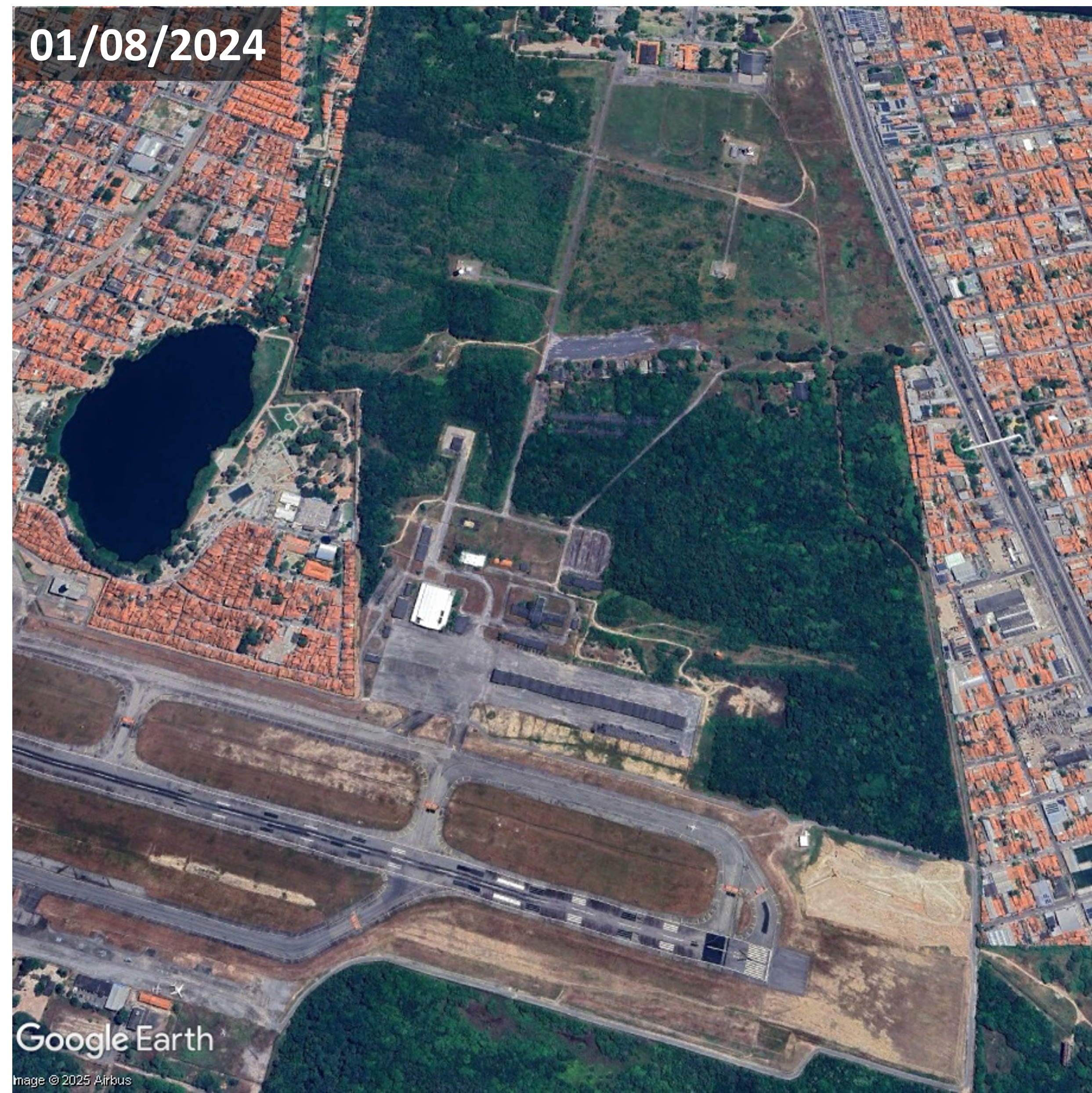
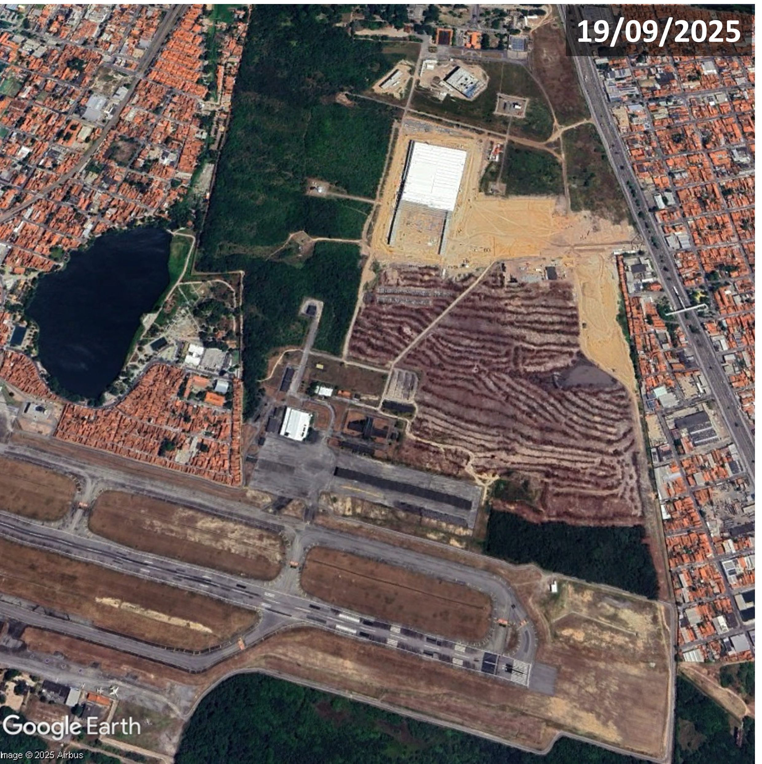
Aerial imagery of Fortaleza Airport showing deforestation that was reported in September 2025
Deodato Ramalho, IBAMA superintendent, said the forest around Fortaleza Airport and Cocó state park are the only city’s only remains of the Atlantic Forest, extending along a long stretch of Brazil’s Atlantic coast and important for temperature regulation and flood prevention. Ecologist and Fortaleza city councillor Gabriel Aguiar said trees had been felled with chainsaws and reforesting the area would take many years. Daniel Pagliuca, an environmental lawyer and professor at Baturité Massif University Center, said forest clearance can be permitted for projects with public utility, but a logistics center would not directly benefit the local population. Animal rights experts raised concerns that many animals’ lives were in danger as forest clearance forced them into urban settlements. Images on social media showed animals climbing walls and poles around the airport.
Following analysis and site investigation Aerotrópolis Empreendimentos’ license and authorisation were suspended due to intervention in a Preservação Permanente (APP), (Permanent Preservation Area) and wildlife management inadequacies. Aguiar said the tree felling around the airport was the largest deforestation in a decade. Before and after satellite images showed total removal of trees and partial construction of a warehouse in the project area, immediately north of the western end of the runway. Residents and environmental and civil society organizations raised concerns over the logistics center project’s environmental impacts and demanded improved transparency in the licensing process.
During the 2nd October 2025 Encontro Nacional de Gerenciamento Costeiro (National Coastal Management Meeting) members of several social movements protested devastation of the Atlantic Forest around Fortaleza Airport. Environmental leaders from all over the country along with Ceará citizens called for revocation of Fraport’s license, accountability for the firms involved and reforestation of the deforested area. A banner read ‘Who killed the airport forest? 40 hectares of Atlantic forest devastated’ and signs stated that Atlantic Forest had been felled in the absence of a socio-environmental study or wildlife management. A total of 46-hectares had been cleared for construction of a logistics center, which has the potential to be one of the largest facilities of its kind in northeastern Brazil with seven warehouses, a truck service center, gas station and fuelling point. Residents around the impacted area were experiencing higher temperatures; preliminary research comparing surface temperatures from the same time period the previous year indicated an increase of at least 6 per cent, thought to be related to the deforestation.
After an inspection uncovered irregularities including removal of vegetation exceeding authorized limits SEMACE issued Aerotrópolis Empreendimentos with a USD37,315 fine and suspended land use permits in the affected area. At a conference considering amendments to the draft Fortaleza Master Plan a 200-hectare Zona de Preservação Ambiental (ZPA), (Environmental Protection Zone) around Fortaleza Airport, encompassing the deforested land, was approved. Professor Renato Pequero said the designation increased the possibility that the deforested area might be restored. Gabriel Aguiar welcomed the victory and called for the city’s biggest ever mobilization to ensure approval of the ZPA proposal.
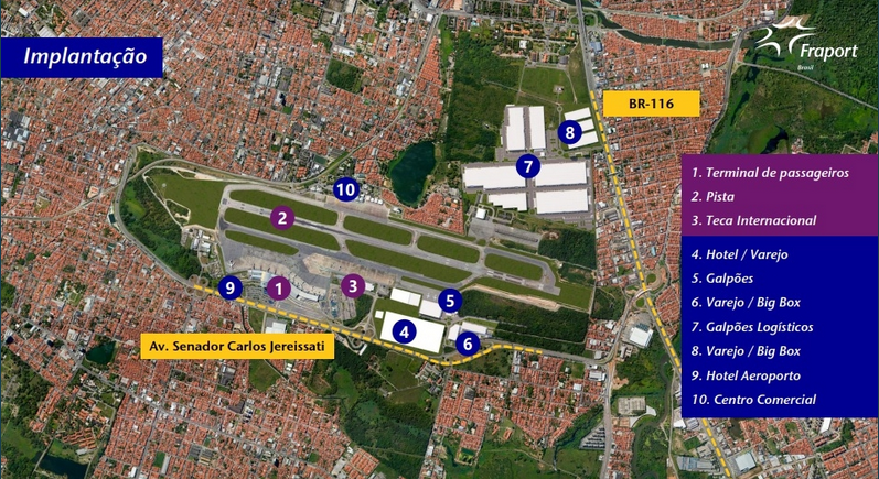
Fortaleza Airport City plan graphic – Fraport announced expansion on land adjacent to Fortaleza Airport in 2022. Source: Fraport Brasil
The logistics center next to Fortaleze Airport is part of a larger airport city project. In July 2022, Fraport Brasil announced expansion onto land adjacent to the airport for Fortaleza Airport City, a development of over 80 hectares. Along with a logistics center planned facilities included two hotels with independent access to the airport, shopping mall and supermarket. A graphic published with the announcement shows logistics warehouses, big box retail, a hotel and commercial center.
For more information including references for all source material, photos and videos see the case study on EJAtlas, the world’s largest, most comprehensive online database of social conflict around environmental issues – Deforestation around Fortaleza Airport, Brazil
Many local and diaspora organisations are opposing Esencia, a luxury tourism and residential megaproject with a private airport, in Cabo Rojo. The development has been granted generous tax credits and would require vast volumes of water.
In May 2024 two real estate firms, Reuben Brothers and Three Rules Capital, filed a master plan for Esencia, a USD2billion development in Boquerón Bay, Cabo Rojo on the west coast of Puerto Rico. Anchored by international hotel operators Mandarin Oriental Hotel Group, Aman Group and Rosewood Hotels and Resorts and containing up to 500 luxury hotel rooms and 900 tourist residences the complex would have a private airport. The Esencia website says the new ‘residential and hospitality community’ will have 3 miles (4.8km) of ‘pristine beachfront’. Plans also included two golf courses, spa, wellnesses centre, health clubs, equestrian centre, hiking and biking trails and a school.
The proposed Esencia plan, with sea views and a private airport, includes luxury hotels and residences and two golf courses. Image source: Reuben Brothers
The Esencia project was granted more than USD497 million in tax credits and in August 2024 four new tax exemptions of between 90 and 100 per cent were approved. A new decree granting 100 per cent fuel tax exemption for tourism-related activities was criticised for incentivising high levels of fossil fuel usage. Comité por la Verdadera Esencia del Suroeste sent statements to multimedia platform Marea Ecologista concerning the proximity of the project site to protected ecologically sensitive areas providing habitats for endangered birds such as the Puerto Rican nightjar. Responding to the absence of public hearings on permits and boundary demarcation for the Esencia project a town hall was convened by local community, environmental and cultural groups on 28th September 2024 where further detail of Esencia project components, including shopping malls and renovation of an airstrip to accommodate small aircraft, was shared.
The land within the site is rural and falls under two classifications. One category is rural land protected because of its ecological importance as it is located between two nature reserves and serves as a corridor for many species and also for its recreational value. The second category is rural land where there is more flexibility regarding development and in recent years mechanisms to evade compliance with the land use plan have been deployed such as declaring projects to be strategic or of critical importance. The project area contains at least 24 archaeological sites from the colonial and pre-colonial eras, many of which have not yet been explored.
On the first day of public hearings in March 2025 Cabo Rojo’s streets were filled with protesters holding posters and banners, many declaring ‘No to Esencia’ and calling the project an enclave for a small number of billionaires. The hall was not big enough to accommodate all the people opposing the project so many watched the proceedings on a screen in a tent outside. Puerto Rican groups opposing the project joined forces under the slogans ‘Defend Cabo Rojo’ and ‘No to Esencia’. The anti-Esencia movement gained support from Puerto Rican diaspora and pro-independence organisations, amplifying locals’ calls for cancellation of the project and holding protests throughout New York. For example, protesters occupied the lobby of the Mandarin Oriental Hotel and unfurled banners in the luxurious Columbus Circle shopping mall.
Officials said the project’s environmental impact statement (EIS) did not address the impacts on infrastructure and ecosystems and lacked hydrological studies. Esencia would place additional strain on water supplies, consuming more than 1.25 million gallons per day, a volume equal to more than a third of current consumption in the Cabo Rojo Municipality. This is a low estimate as it does not include the project proposal’s two golf courses which would increase the volume of water consumed per day to 2 million gallons. The development would require extraction from aquifers or connection to the existing drinking water system but neither of these options are feasible. Local fishers expressed concerns over the risk of damage to oyster beds and disruption of freshwater and saltwater flows that are essential to the health of the estuarine environment.
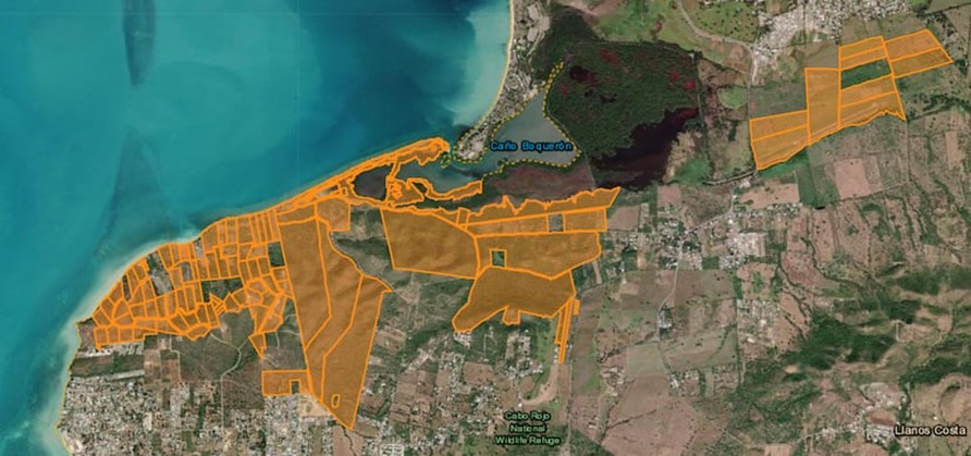
Many of the properties purchased for the Esencia project are shown in orange, agricultural land purchased in August 2025 is shown to the right. El Nuevo Día, 20/09/2025
By September 2025 project investors had spent approximately USD147 million on properties for Esencia and were on track to acquire the target of 809 hectares of land. Recent land parcel purchases were part of the Reserva Agrícola del Valle de Lajas (Lajas Valley Agricultural Reserve) and an airstrip. On 12th September the Department of Natural and Environmental Resources (DNRA) published a 29-page report firmly reiterating its opposition to the Esencia project and concluding that the plans did not comply with environmental laws. Significant findings included fragmentation of habitats hosting endangered bird species, severe impacts on Catesbaea melanocarpa, a rare, endangered lily and threats to the habitat of Anolis poncensis, a rare lizard species. The project’s so-called ‘ecological corridors’ lacked the connectivity of existing ecosystems and golf courses, artificial ponds and landscaping claimed to be mitigations would be part of the project’s negative impacts.
For more information including references for all source material and photos see the case study on EJAtlas, the world’s largest, most comprehensive online database of social conflict around environmental issues – Esencia project, Puerto Rico
Construction of the Great Transfiguration Project – a mega tourism development n the St. Catherine areacomprising luxury hotels, villas, chalets, visitors centre, shopping bazaars, housing and roads –is linked to expansion of St. Catherine Airport.
Great Transfiguration Project (GTP) area, Egypt. Aerial imagery: 2nd July 2023
The Great Transfiguration Project (GTP), a mega tourism development project including hotels, villas, chalets, private housing, shopping bazaars, other facilities and roads in and around the St. Catherine area – a designated UNESCO World Heritage Site which includes St. Catherine’s Monastery and Mount Sinai – was announced by the Egyptian government in March 2021. Within weeks demolitions and construction works by private companies began. An August 2022 statement by the Egyptian Human Rights Forum (EHRF) detailed the project components, situation on the ground, impacts on and response from local communities and NGOs and comments from experts. Many contributors confirmed that GTP implementation had already caused serious, irreversible damage of nature, ecosystems, heritage and negative impacts on local people. EHRF’s statement said authorities had not included the local Jebeleya Bedouin tribe or the wider local community and that local organisations, community representatives, experts and representatives of St. Catherine’s Monastery (one of the oldest continuously inhabited monasteries in the world) and its inhabitants had not been consulted. A St. Catherine’s expert said homes were being demolished without compensation, part of the mosque had been demolished and the cemetery dug up. An eyewitness said many old olive and pistachio trees had been removed and some locals had worked together to replant them in different gardens. Construction of a 70km highway connecting St. Catherine with Al-Tur, on the Gulf of Suez, raised concerns over the environmental impacts. An expert on St. Catherine’s natural environment said, “This highway destroys an area designated by Egypt’s government as a nature protectorate, it cuts through the protected area and splits it in two, causing environmental ruin.”
In March 2022 a Middle East Eye correspondent gathered testimony from several local people concerned about the impacts of the GTP. One resident spoke of concern for the future of the heritage site, saying, “What is sold to us as development is in fact ruining this ancient and beautiful city.” A tourism worker, one of several people commenting on social media and posting photos of demolished buildings, said, “The view to most of the ancient sites of the city will be blockade by the concrete buildings now constructed in it”. One resident spoke of bulldozers tearing down important buildings, replacing them with blocks of concrete. Another resident said, “We wake up every day to discover that some buildings have been demolished and other made of cement constructed instead of them.” Mada Masr reported that two anonymous sources said the government began implementation of the project before submitting environmental impact assessments. A resident raised concerns over the project’s water consumption in a city reliant on wells and tanker trucks from Al-Tur saying, “Where will you get water for those employed in hotels, chalets and homes? They’re building swimming pools while people still wait for the water trucks once a week.” Accommodation built for relocation of residents, apartments in multi-storey buildings, some of which were already housing displaced residents, were very different from Bedouin’s traditional single-floor dwellings with gardens. One resident said, “These do not look like our homes nor do they align with our customs. We would not know how to live comfortably. But when they relocate us, we will have no other choice.”
Concluding a 10th March 2024 inspection tour in St. Catherine to assess the development projects Prime Minister Mostafa Madbouli said the GTP would be Egypt’s gift to the entire world. He said the state had made significant efforts to implement the project, beginning with development of St. Catherine International Airport, located 20km northeast of the city, into an international airport. A World Heritage Watch press release entitled ‘Mount Sinai: A Sacred Landscape Disfigured by a Megatourism Project’, issued on 18th December 2024 stated, “A new urban world is being built around a people of nomadic heritage,” It stated that the site surrounding St. Catherine’s monastery had been transformed. Landscapes had been damaged, the rights of indigenous people violated, houses demolished, important cultural sites destroyed and Bedouins had lost tribal territories. Heritage groups around the world had raised the alarm about the scale of commercial and infrastructure development in St. Catherine. Fourteen plots of land confiscated from the monastery by the Court of Appeals included agricultural land, gardens and buildings protected as antiquities including Saint Panteleimon Church on Mount Sinai which dates back to the 6th-7th centuries. In 2023, UNESCO had asked the Egyptian government to halt further development projects, evaluate the impacts and prepare a conservation plan for the area. The requests were ignored and construction of concrete buildings including luxury hotels, new roads and development of St. Catherine’s Airport into an international facility with a 3km runway, enlarged terminal and VIP lounge continued. Speaking to New Lines Magazine in June 2025 an anonymous resident said, “the fate of personal property that falls in the way of this construction remains unclear. Assurances and fake promises change day by day.” An anonymous expert said Jebeleya people’s homes were being demolished with no compensation. The aforementioned bulldozed cemetery had been paved over to create a parking lot. Plans for 700 new housing units caused worries that Bedouins might be displaced. An anonymous expert said, “Many fear they could be compensated with an apartment, which does not suit their way of life. They need outdoor space – for their livestock and to plant.”
For more information including references for all source material see the case study on EJAtlas, the world’s largest, most comprehensive online database of social conflict around environmental issues – Great Transfiguration Project, Egypt
Guwahati Airport and the villages of Azara, Garal and Mirzapur. Satellite imagery: 03/04/2024
A land acquisition notice for a proposed Aerotropolis near Guwahati Airport – the primary airport of northeast India located in the west of Assams’ largest city and also known as Lokpriya Gopinath Bordoloi International Airport (LGBI) – met with anxiety, anger and opposition from many affected residents. Issued on 25th July 2025 by the Kamrup Metropolitan District Administration the notice encompassed 400 bighas (101 hectares) of inhabited and uninhabited land in the villages of Azara, Garal and Mirzapur and impact upon more than a thousand families. Many villagers had given land for construction of Guwahati Airport decades ago and feared loss of their homes and livelihoods. An Azara resident said, “We have already given away vast stretches of land. Now this fresh move will leave many of us homeless.” In Garal village, where the district administration moved to acquire 70 bighas (17.7 hectares) of land for the Aerotropolis project, over 100 pattadars (landholders) were named in the land acquisition notice. Critics of the project claimed the land acquisition process lacked transparency, consultation or a clear plan to rehabilitate affected people and that the main beneficiary would be a private company. Guwahati Airport is owned by Adani, one of India’s largest multinational conglomerates. A local committee member said, “Guwahati Airport is now under Adani’s ownership. So the land being acquired in the name of an airport township will ultimately go to Adani.”
Affected families began to protest the land acquisition process, demanding transparency, a thorough impact assessment and guarantees that they would be rehabilitated. “We are not against development”, said an affected farmer, “But we deserve clarity, transparency and fair compensation. Right now everything feels juggled up and a lot is hidden from the public.” Protests took place in many affected areas. Leader of the Opposition Debabrata Saikia described the move to acquire land for the ‘Aerocity‘ as anti-indigenous and serving corporate interests. He said more than 1,116 families were affected, some of which had held land titles for nearly 200 years. He also warned that, in addition to the families facing displacement, local entrepreneurs in the area running guesthouses and restaurants would be adversely impacted. The location of the project site, near the Deepor Beel freshwater lake, a Ramsar site (designated as of international importance under the Ramsar Convention) raised environmental concerns.
Land acquisition for the aerotropolis had been requested by the managing director of the Assam Industrial Development Corporation (AIDC). Akan Chandra Das, president of Mirzapur Anchalik Bhumi Suraksha Samiti, the committee representing affected residents of Mirzapur, Azara and Garal villages, said, “Already nine to ten times, our families gave land to the government post-independence, for development of the airport, adjacent roads, and defence establishments near the Guwahati airport. If the remaining land is also taken for development projects, where will we go? How will our children survive if they don’t get jobs in other sectors?” Basudev Mali, a retired teacher and owner of 10 bighas (2.53 hectares) of land near the airport, in Mirzapur, said, “If the government continues to take over our lands for airport expansion or for aerotropolis development now, who will ensure the survival of our children? The remaining farmlands were our only hope, but the government wants to take that also.”
A residents’ delegation met with Chief Minister Himanta Biswa Samra, but his attempts to reassure them that only vacant land would be used, for public projects were unsuccessful. Locals remained reluctant to give up their land for either government or private projects. Villagers attending a public meeting in Mirzapur unanimously resolved not to give their land to the government under any circumstances, declaring, “Our land is our identity and livelihood. We will not give it away at any cost.” At the beginning of September 2025 the Guwahati Metropolitan Development Authority (GMDA) suspended building permits and land sales in the proposed aerotropolis area around Guwahati Airport. Additional restrictions were also imposed. The suspension affected Azara, Garal and Mirzapur villages where hundreds of indigenous families were unwilling to vacate their land for the aerotropolis project. They also opposed the notice issued by GMDA as it restricted their rights as landowners.
A new international airport under construction in the Pedernales province in the southwest of the Dominican Republic, for commercial and private flights, is integral to development of a high-end coastal tourism complex.
Cabo Rojo International Airport construction site. Satellite image 09/09/2024
In January 2024 the government of the Dominican Republic announced construction of a new international airport in the Pedernales province in the southwest of the country. The site is in the Manuel Goya community, part of the Oviedo municipality. A Spanish firm, Acciona Construction SA, was awarded the contract to build Cabo Rojo International Airport, even though its bid was the most expensive. The RD$3,961 million (€62 million) contract, awarded in June 2024, included construction of a 3.1 kilometre runway, taxiway, aprons for Boeing 777 aircraft (the world’s largest twin-jet aircraft accommodating up to 368 passengers) and drainage works. The new airport will serve luxury tourism and private aircraft (private jets). Director of the Airport Department, Víctor Pichardo, highlighted the new airport’s potential to transform tourism in Pedernales by attracting both commercial flights and private aviation, noting that each year more than 40,000 private aircraft fly over the Carribean. He said the new airport would position the Dominican Republic as a hub for high-end tourism. Construction of the new Cabo Rojo Airport (also known as Pedernales Airport) is scheduled to be complete by the end of 2025; it is anticipated to handle up to 1 million passengers annually within 17 years, making it the third busiest airport in the country.
Artist rendering of development of planned luxury tourism development near the new Cabo Rojo International Airport and expansion of Port Cabo Rojo. Image: Dominican Today
The new Cabo Rojo International Airport, will form the basis for a new coastal tourism complex with 12,000 rooms located just 15 minutes away (about 25 km). The two locations are already connected by a major highway: DR Route 44. The tourism complex site is near the existing Cabo Rojo Domestic Airport, a civic/military airport currently receiving a few small aircraft, carrying 2-30 passengers, per week and serving operations of the Dominican Air Force. Tourists will also be delivered to new resorts via Port Cabo Rojo, which is expanding into a facility capable of receiving two large cruise ships carrying up to 15,000 visitors. Large volumes of fresh water will be diverted to the tourist area via a new aqueduct which will supply 8,000 tourism rooms. As of July 2024 the ProPedernales tourism development trust, a Public-Private Partnership (PPP) with the government holding a 52% stake and the private sector holding 48%, reported a total investment of USD130 million on Cabo Rojo tourism, focused on the first three hotels and the airport runway. In addition, the Dominican Government had spent nearly USD30 million on water projects, site conditioning, planning and design to prepare for and support the initiative.
Six major international hotel chains, ‘a who’s who of luxury and all-inclusive resorts’, are building new properties in Cabo Rojo: Hilton, Marriott International, therostar Group, Karisma Hotels & Resorts, Amresorts (part of World of Hyatt) and Sunwing. Luxury tourism development just 15 kilometres away from the border with Haiti, gripped by gang violence and a humanitarian crisis, might seem incongruous. But the Dominican Republic has reinforced the border with Haiti with more than 13,000 troops and the first phase of a high-tech ‘smart’ border wall with drone patrols, surveillance towers and night vision cameras is nearing completion. The exclusivity and high security requirements of luxury tourism can go hand in hand with militarisation; the established Cabo Rojo Airport nearby already serves the Dominican Air Force.
At a June 2025 National System of Protected Areas (SNAP) conference a number of environmental experts stressed the importance of responsible tourism development in Cabo Rojo, avoiding repeating the mistakes of some other Dominican tourist destinations by protecting the region’s ecology and directly benefitting local communities. But problems have been reported in the earliest stages of Cabo Rojo’s tourism development. In August 2024 environmental organisation Grupo Jaragua said the project was proceeding without clear compensation plans for affected residents of the Oviedo municipality, where the airport is being constructed. A community leader reported that tractors had destroyed land. Two months later a truck drivers’ union took strike action protesting non-payment for tranport of fill materials used for airport construction, saying the amount being paid per kilometre was not even sufficient to cover their fuel costs. The government is providing a high level of financial and infrastructural support to tourism and airport megaprojects that will primarily benefit airlines, major international hotel chains and cruise ship lines, not local businesses, and only wealthy visitors will be able to afford to stay in the luxury hotels. And the new high-end tourism complex may well boost the number of private aircraft flights, only affordable to a small number of very wealthy people, at Cabo Rojo Domestic Airport.
Vlora Airport, opposed by many environmental organisations, has received a high level of government support and will serve luxury tourism developments.
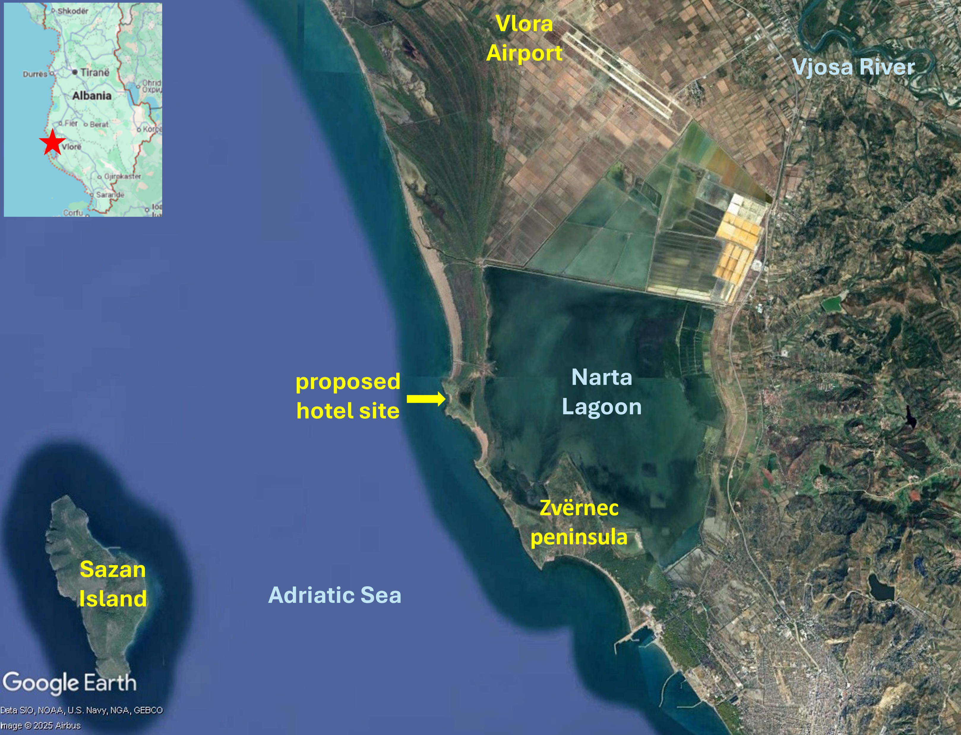
Map of southern Albanian coast showing Vlora Airport, Sazan Island and Zvërnec peninsula. Satellite imagery: 29/08/2023
Vlora Airport, a major construction project nearing completion in the Vjosa-Narta Protected Landscape on the South Albanian coast, has been opposed by many environmental organizations, including Protection and Preservation of Natural Environment in Albania (PPNEA) and EuroNatur, since it received parliamentary approval in February 2018. The project site is near Narta Lagoon, a habitat for many iconic bird species such as flamingos and the endangered Dalmatian pelican. The wider Vjosa Delta area, a complex of wetlands, marshlands, woodlands, reedbeds and sandy beaches, is vital for bird migration routes. A March 2021 letter from a coalition of NGOs to members of the European Commission and Parliament, calling for support in urging the Albanian government to respect national laws and international conventions it has ratified, and to reconsider plans for the airport, was signed by 41 organizations. In the same month it was announced that Mabco Constructions had been awarded the tender for constructing Vlora Airport.
On 7th May 2025, the day before the first test flight landed on the Vlora Airport runway, environmental activists, including representatives of PPNEA and citizens, protested in front of the Supreme Court. For over a year the court had not made a decision on returning a case against construction of Vlora Airport to the Court of Appeal; the lawsuit had been filed on 23rd November 2022. Protesters said the Supreme Court had deliberately delayed the legal process in order to facilitate completion of Vlora Airport. The first plane to land at Vlora Airport, on 8th May 2025, was the private plane of Behgjet Pacolli, owner of Mabco Constructions, the majority shareholder of the consortium constructing the airport. EuroNatur dismissed the test flight, showcasing Vlora Airport just three days before parliamentary elections, as a “big PR show”. The airport was not yet fully operational, neither the runway nor the terminal had been completed. Alexander Trajce, PPNEA Executive Director, said, “While the government is flying-high with the propaganda for the airport, what’s actually happening on the ground involves a rushed and chaotic development built inside a protected area, a myriad of safety concerns both during construction and for future operations.”
Construction fatality and investigation into possible corruption
Just 19 days before the test flight an accident a construction accident resulted in a fatal injury. A 38-year-old worker at the Vlora Airport site died on 19th April 2025 after falling from a height. Two construction company employees were arrested on suspicion of violation of workplace safety regulations. Construction of Vlora Airport has also triggered investigation into possible corruption. The Special Prosecution Office against corruption and Organised Crime (SPAK) announced the investigation in early July 2025, stating, “The Special Prosecution Office against Corruption and Organized Crime has registered criminal proceedings regarding the Vlora Airport concession contract. This proceeding is in the preliminary investigation phase.” SPAK is investigating the details of the agreement between Mabco Constructions owner Behgjet Pacolli and the Albanian government and the contract for Vlora Airport construction.
An unprotected delta and Law 21/2024
Conservationists had been hopeful that the government’s creation of Vjose Wild River National Park in 2023 would protect the Vjosa Delta from further destructive development. But the designation only covers the river and streams, not the delta which remains a target for commercial development, with only limited protection subject to Prime Ministerial veto. As airport construction continued, near Narta Lagoon at the heart of the delta, Zydjon Vorpsi of PPNEA warned that while the lagoon may still exist as a water body there will be serious hydrological impacts and aircraft noise and bright lights will disorientate and frighten away birds and turtles. Vorpsi also said Vlora Airport would lead to other development that will “transform the area, resulting in complete urbanisation of the delta”. Development in areas surrounding Vlora Airport has been facilitated by Law 21/2024, a change to the law on protected areas that was rushed through the Albanian parliament in February 2024. Many environmentalists were critical of the new legislation as it enables existing laws to be swept aside to permit construction of upmarket, luxury, five-star, tourism resorts in unprotected areas of the delta. PPNEA, EuroNatur and other environmental and conservation groups said the new law conflicts with international conventions signed by the Albanian government, including the Bern Convention on the Conservation of Wildlife and Natural Habitats. In 2023 the convention’s Standing Committee urged the Albanian government to halt construction of Vlora Airport pending a thorough environmental impact assessment. Law 21/2024 was ratified by President Bajran Begaj only three days after plans for two luxury tourism developments in the delta area were announced by US President Donald Trump’s son-in-law, Jared Kushner.
Luxury tourism proposals – Zvërnec peninsula and Sazan Island
The sites of both proposed tourism projects – the Zvërnec peninsula and Sazan Island – are within protected areas. The Zvërnec peninsula is part of the Pishë Poro-Nartë protected area and Sazan Island is in Karaburun-Sazan national marine park. The Zvërnec peninsula, to the south of Vlora Airport, is a promontory with pine forest and attractive beaches, connected by a wooden bridge to the remains of St. Mary’s, a 13th century Byzantine monastery on a small island in Narta Lagoon. Zvërnec would look very different if the tourism development goes ahead; a 445-hectare luxury resort is envisaged hosting about 6,000 hotel rooms and villas. Architectural renderings of the project published by Kushner’s Miami-based investment company, Affinity Partners, show rows of modern, multi-storey buildings alongside Narta Lagoon and on the dunes, headlands and beaches, a commercial centre, swimming pools, marinas, yachts and a cruise ship.
Plans for a 567-hectare development on Sazan Island are equally high-end. Nearly 10 kilometres west of Narta Lagoon, Sazan is currently uninhabited and one of only a few undeveloped islands in the Mediterranea. Interest in the remains of a heavily fortified military base have made Sazan Island into a tourist attraction; in summertime several ships and dozens of boats provide day trips. The island has a subtropical climate and highly biodiverse vegetation including ash, hornbeam, maritime pine and holm oak trees along with rare ferns. Marzio Mian asked Asher Abehsera, a real estate executive overseeing the Affinity Partners projects, whether the Sazan Island would still be accessible to local people. He replied, “I think everyone should have the opportunity to visit the island”. Kushner’s response seemed more indicative of plans for an exclusive enclave, “We’re creating a very high-end luxury product … One of the most compelling points about the island is just the ability to have privacy … But I also think there are certain aspects of the island we can build out that will give people the opportunity to come visit and enjoy some of the food and the trails.”
Strategic investor status for Sazan Island project
The Albanian government approved Kushner’s request to develop Sazan Island in January 2025 when it granted the project strategic investor status. The government announcement reads: “The projected investment of Sazan Island Touristic Resort of 1.4 billion euros fulfils the criteria foreseen in the legislation on strategic investments.” The project also met the criteria relating to employment, anticipated to be 1,000 people during the construction and operational phases. Strategic investor status will grant Affinity Partners zero taxes in the construction phase and the government will provide all the requisite infrastructure including electricity, water and sewage. Director of EcoAlbania, Olsi Nika, a marine biologist voiced concerns about beaches and waters protected by the Karaburun-Sazan maritime national park designation, saying, “What will large public works, the building of docks, yacht traffic and sewage run-off do to the place?”
Albania’s luxury tourism strategy
Vlora Airport and Affinity Partners’ proposed tourism developments are important components of Prime Minister Edi Rama’s campaign to transform Albania into a “champion of tourism”. PPNEA’s Zydjon Vorpsi said this would come at a huge ecological cost including to birdlife and cast doubt on the purported economic benefits. An influx of visitors to seasonal resorts in summer would place a strain on local infrastructure, leaving empty “ghost towns” in the winter. He also said it was likely that most of the tourism revenue would accrue to the firms owning the developments, not to the local community. Kushner has welcomed the government’s support for Affinity Partners’ luxury tourism projects and development of Vlora Airport. Writing in The Guardian, Marzio Mian recalled a conversation in which Kushner described Rama as a “great partner” and said of the government, “They’re building an airport right there”. Noting that in 2024 almost 12 million foreign visitors, a 15 per cent increase compared to the previous year, had travelled to Albania, Mirela Kumbaro, minister for tourism and the environment, said the number was too high, “too many for us, and too much pollution”. Kumbaro said, “Sazan is the way to go. The ideal recipe: nature and luxury tourism.” The Albanian government is extending a great deal of support to elite tourism which will benefit a small number of wealthy visitors. And the focus on developing exclusive resorts in the undeveloped southern coast appears to be at odds with the scale of Vlora Airport. The 3.2 kilometre runway is the longest in the Balkans and Vlora Airport is expected to become the second-largest in Albania with an initial capacity for 2 million passengers per year, expanding to accommodate ten million within a decade.
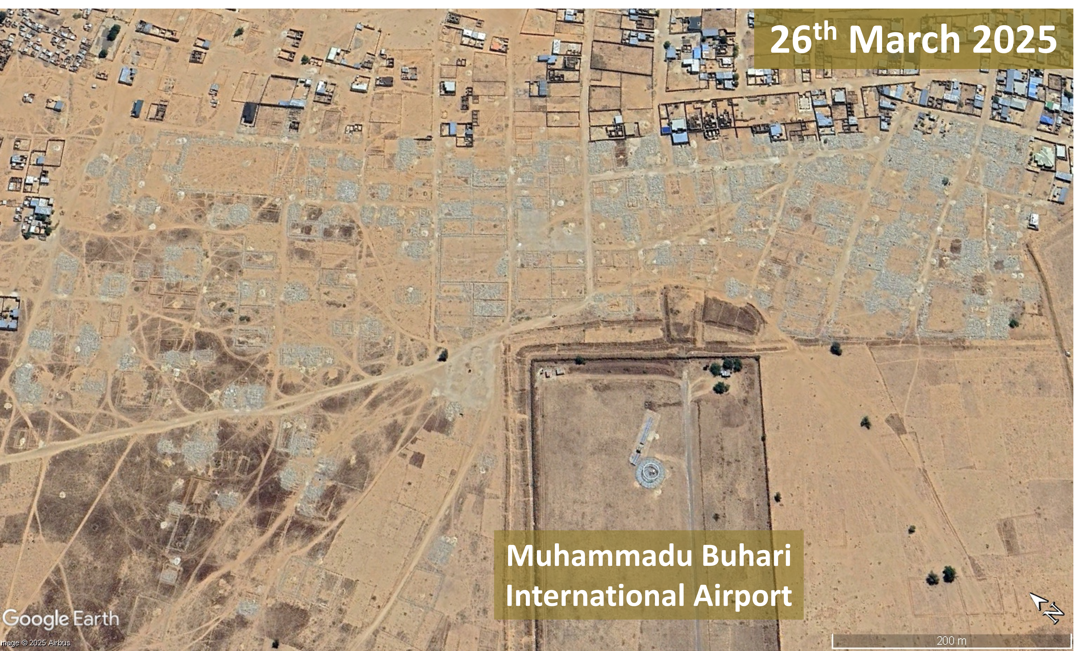
Hundreds of people were displaced by a demolition exercise to make way for expansion of Muhammadu Buhari International Airport
On 30th January 2025 a number of residents of Shuwari 5 ward in Maiduguri, near the Muhammadu Buhari International Airport runway, reported that the Borno State Government was demolishing their houses. A bulldozer destroyed houses while residents retrieved essential household items. People whose houses were still standing but had been marked for demolition worked to remove roofs from their houses. One resident said people had received only three days’ notice before their homes were demolished and appealed to the Borno State Governor to provide compensation or alternative shelter for affected residents as they had no other place to go to.
Aerial imagery of the Shuwari 5 area near the end of Muhammadu Buhari International Airport runway before and after the demolition exercise beginning on 30th January 2025 shows buildings reduced to rubble.
On a visit to Borno State in October 2024 Minister of Aviation and Aerospace Development, Festus Keyamo, had announced that Muhammadu Buhari Airport had been upgraded to international status and would commence operation as an international airport from 1st January 2025. The General Manager of Borno State Urban Planning Development Board, Liman Mustapha, said the purpose of the demolition exercise beginning on 30th January 2025 was to secure land for upgrade of the airport. He also said there would be no compensation for affected house owners and that residents had been informed that their occupation of the land was illegal in 2020 and since then authorities had attempted, unsuccessfully, to stop construction of houses on the land.
The demolition exercise targeted the area up to 500 metres from the airport fence, beginning with the area within 200 metres. Adamu Matankolo, Acting Regional Manager of the airport, said upgrade of the airport to international status by the federal government necessitated its expansion. He said, “We sympathise with the people who don’t want to obey this order. We have our plan and out plan is that the area slated for demolition is a buffer zone.”
Premium Times reported that more than 100 houses were demolished and many of the affected people had occupied the area for over 10 years having been displaced by the Boko Haram insurgency. The IDPs (Internally Displaced Persons) thought their resettlement was permanent until the state government demolished their houses. An IDP and single mother of three children said residents received a notice from the Borno State Geographical Information Service (BOGIS) just a few hours before the demolition exercise began.
Many people criticised the State government’s handling of the demolition exercise on social media, in the context of the Borno state’s socio-economic problems caused by the Boko Haram insurgency and a recent flood impacting 40% of the city of Maiduguri. Commenting anonymously a Maiduguri-based lawyer gave a detailed statement on the government’s obligations regarding compensation, concluding: “Thus, if a house is built on government land without approval, the owner is generally not entitled to compensation. However, if the government initially allowed of overlooked the development, there is scope for negotiation or legal redress.”
HumAngle, a media platform focussed on conflict, humanitarian, and development issues in Africa, reported that the demolition had displaced hundreds of people. One of them, a widow raising four children who had lived in Shuwari 5 for 17 years, said the government only notified people about the demolition two days before bulldozers arrived, not even giving enough time for gathering belongings. She said at least three affected people had died of shock and more than 20 had fallen ill due to trauma.
Liman Gana, head of Borno State Building Planning Authority, said 306 structures had been demolished, including 64 fully occupied houses, 42 incomplete structures and 17 incomplete buildings. A Federal Airports Authority of Nigeria (FAAN) official gave technical and safety reasons for the demolition exercise, saying structures built too close to the runway posed safety risks. Many displaced residents insisted that they were not informed of these risks before they bought or built their homes and said resettlement should have been planned and implemented before the demolitions took place.
Up to 70,000 climate refugees face displacement to make way for Cox’s Bazar Airport and Air Force Base expansion and more than 20,000 could be ineligible for replacement flats in the Khurushkul Ashrayan Project. On 7th January 2025 thousands of people protested against eviction.
Map of Cox’s Bazar Airport, Bangladesh Air Force (BAF) base and Khurushkul Ashrayan Project. Satellite imagery 25th March 2025
Since 1981 climate refugees – people displaced by cyclones, river erosion and tidal surges from many of Bangladesh’s coastal areas – have resettled in Ward 1, Cox’s Bazar Municipality. The area is government-owned ‘khas’ land between the Bay of Bengal and Cox’s Bazar Airport and the adjoining Bangladesh Air Force (BAF) base. The largest influx of climate refugees occurred in the aftermath of a cyclone and tidal wave on 29th April 1991 when about 40,000 people displaced from Kutubdia Island settled in the area. In February 2011 several local leaders demanded cancellation of a project to expand Cox’s Bazar Airport. Officials had moved to acquire 16 areas in Ward 1 – including Kutubdiapara, Samitypara, Fadnerdail, Bandarpara and Naziraratek – and 40,000 people would become homeless. In 2012 the Civil Aviation Authority of Bangladesh (CAAB) began a project to extend Cox’s Bazar Airport runway. In 2021 an agreement for another runway extension, lengthening it northwards into the Maheshkhali Channel through land reclamation, was signed.
Climate refugees face eviction
An in-depth investigation of the climate refugees from Kutubdia Island who had settled in Ward 1 was published in December 2024. They were still vulnerable to extreme weather; storms would leave many homes flooded with seawater and the area lacked cyclone shelters. Neither Cox’s Bazar Municipality nor the Chittagong District had precise data on the number of people living in Ward 1 but Akter Kamal, elected three times to represent Ward 1 and now a former councillor, said at least 52,000 people resided there. The investigation found that ‘Every household in the climate refugee camp lives inconstant fear of eviction. All the khas land in the area has been acquired for the expansion of Cox’s Bazar Airport’s runway and the construction of an air force base’.
Resettlement in the Khurushkal Ashrayan Project
The Khurushkal Ashrayan Project, located 3 kilometres east of Cox’s Bazar Airport, was described as ‘the world’s biggest climate refugee rehabilitation project’ when the then Prime Minister Sheikh Hasina inaugurated the first phase, housing 600 families, on 23rd July 2020. It was stated that upon completion 139 five-storey blocks would rehabilitate 4,409 families, the majority living in the Cox’s Bazar Airport area since being displaced by the 1991 cyclone. By December 2024 another 85 buildings had been completed which would accommodate 2,270 families. But former councillor Akter Kamal said that at least 20,000 climate refugees living in Ward 1 were ineligible for flats. Changes to the list of project beneficiaries had caused anxiety to between 20,000 and 22,000 climate refugees who were excluded from the resettlement plan.
Thousands protest eviction plan
On 7th January 2025 thousands of climate refugees, including residents of Samitypara and Kutubdiapara, held a protest demanding cancellation of the eviction plan linked to Cox’s Bazar Airport expansion. Demonstrators blocked roads causing traffic disruption with several thousand people blocking the main city road for 2½ hours, protesting eviction and calling for long-term settlement and holding a rally in front of the Deputy Commissioner’s office. They had lived in their settlements in Ward 1 for 20-30 years but instead of rehabilitating them plans were being made to evict them. Former councillor Akter Kamal told Prothom Alo that between 60,000 and 70,000 climate refugees were living in the area and land had been acquired for Cox’s Bazar Airport runway expansion and air force base construction. He estimated the number of families not entitled to flats in the Khurushkal housing project as approximately 4,000. Protestors said they would bring the city to a standstill if the government did not reverse its decision to evict them.
Clash between locals and BAF personnel
On 24th February 2025 Shihab Kabir Nahid, a 30-year-old local trader, was killed in a clash between locals and BAF presonnel. His mother said he was standing in the doorway of their house and died after being shot in the head. The Inter Services Public Relation Directorate (ISPR) stated that Cox’s Bazar Air Base had come under a “sudden attack” by unidentified people from the neighbouring Samitypara area. But local residents alleged that the clash was triggered by altercations over BAF’s attempts to acquire land and relocate residents for expansion of Cox’s Bazar Airport and the air base. A Samitypara resident said the clash began as local representatives were on their way to a scheduled meeting with BAF officials about relocation for airport expansion. The Borderlens published an account of the violent incident and the circumstances leading up to it. Climate refugees in Ward 1 had lived in fear for many years, their homes on land earmarked for air base expansion and denied land ownership rights or resettlement. In recent months the eviction drive for air base expansion had intensified. Families’ appeals to the district administration went unanswered and BAF personnel were making threats. Gunfire began after a scuffle and social media footage showed air force personnel firing at unarmed protesters throwing bricks and stones.
Runway expansion impacts on waterway navigability
By March 2025 the runway expansion was 84% complete and aircraft navigation aid lights had been installed on concrete piles extending across the mouth of the Maheshkhali Channel. On multiple occasions the Bangladesh Inland Water Transport Authority (BIWTA) had raised concerns about lack of approvals, consultation and surveys pertaining to the risk of loss of navigability for waterway traffic, but the warnings had been ignored. A report by a committee of experts stated that the pillars in the river obstructed water flow and caused accumulation of sediment at the base of the pillars, narrowing the mouth of the Maheshkhali Channel and reducing navigability. An alternative channel that had been dug out was expanding westwards, posing risks to residents of Sonadia Island. The BIWTA report warned that sediment build-up could affect water routes along the coast from Chattogram to Cox’s Bazar along with the southward route to Saint Martin’s. The report recommended removal of the piling in the Maheshkhali Channel.
For more information, including references for source material, see the case study on EJAtlas, the world’s largest, most comprehensive online database of social conflict around environmental issues – Cox’s Bazar Airport and Air Force Base expansion
A plan for an ‘eco-luxury and tourism project’ encompassing nearly half of Bugsuk Island is the latest of a series of projects triggering a 50-year struggle for recognition of ancestral land and water rights.
Satellite imagery of Bugsuk Island, Balabac municipality, Palawan province, 27th October 2024. Bugsuk Airport and other facilites are indicated.
In 1974 indigenous Pala’wan, Molbog and Cagayanin people were expelled from Bugsuk Island, part of the Balabac Municipality off the southern tip of Palawan, the westernmost point in the Philippines. An article by Indigenous Peoples’ Rights International (IPRI), based on an interview with Jomly Callon, President of the Sambilog-Balik Bugsuk Movement (Association of Indigenous Peoples and Small Fishers from the Southernmost Tip of Palawan), an indigenous people’s group, outlines a 50-year history marked by projects, facilitated by a series of policy decisions, taking the place of agricultural and fishing livelihoods. The land was awarded to Danding Cojuangco, Chief Executive of San Miguel Corporation (SMC), one of the Philippines’ largest business and industrial conglomerates, who established a nursery for hybrid coconut trees. In 1979 Cojuangco, in partnership with a French businessman, Jacques Branellec, formed the Jewelmer International Corporation which established a pearl farm in ancestral waters. Sambilog was formed in the year 2000 in response to land grabbing and reducing access to fishing grounds, working to gain recognition of ancestral land and water rights. They made an application for a Certificate of Ancestral Domain Title (CADT) which has still not been approved by the government. Indigenous people’s access to traditional fishing grounds was eroded further in 2005 when, without consulting indigenous people, the Balabac municipality was declared a ‘protected marine eco-region’, prohibiting indigenous people from fishing in their traditional fishing grounds. In 2014, following Sambilog protests in Manila calling for return of their lands through the Comprehensive Agrarian Reform Program Extension with Reforms (CARPER) the Department of Agrarian Reform (DAR) issued a Notice of Coverage over agricultural lands for distribution to the people of Bugsuk Island. But DAR did not implement its decision to return the land to those affected by displacement.
After Cojuangco’s death in 2020 Ramon Ang took up the role of CEO of SMC. Bugsuk Airport (also referred to as Bonbon Airport) was built by SMC to support the coconut plantation. In February 2022 Jose Alvarez, Governor of Palawan, speaking about Bugsuk Airport and a Philippine Air Force (PAF) facility in Barangay Catagupan being ‘crucial to the transformation of Palawan’s southernmost region as a new tourist haven‘, said the coconut plantation had failed but that Bugsuk Airport was still under development with the runway already operational and used by people travelling to Balabac. Satellite imagery of Bugsuk island shows Bugsuk Airport, an airstrip near the southern tip of the island that is being developed for the PAF and a helipad. In 2023 the DAR revoked the Notice of Coverage that was issued in 2014 and under which the land would be returned to its original owners. The reason given for the cancellation was that the area is unsuitable for agriculture. Callon, countered this, explaining that residents were cultivating the land, growing many types of vegetables and fruit trees.
Environmental Impact Statement and Master Plan for resort taking up half the island
Bricktree Properties Inc., a subsidiary of SMC, plans to construct various so-called ‘eco’ tourism facilities surrounding Bugsuk Airport. Bricktree’s presentation at a public scoping event held in Bugsuk Community Center, Bugsuk Island on 25th May 2023 contains a timeframe for 2023-24 which includes access road clearing and construction, tree cutting, land clearing, construction of campsites, perimeter fencing and soil compaction. A number of ‘identified environmental impacts’ includes ‘Land tenurial issues and incompatibility with existing land use’, ‘Potential lost (sic) of fish related livelihood and conflict on the access/navigation of locals’ along with potential changes in water quality, water competition and dust from land clearance. The Environmental Impact Statement Summary for the Proposed Bugsuk Island Eco-Tourism Development Project, prepared for Bricktree, contains maps of the proposed site and a Proposed Master Plan comprising serveral zones taking up much of the south of the island along with a port on the northern tip.
The Environmental Impact Statement Summary states ‘The Proposed Project aims to be an eco-luxury leisure and tourism destination governed by sustainable development principles’. A project schedule from 2023 to 2038 is indicated. The project location spans two barangays (districts) – Bugsuk and Sebaring – and the estimated total project land area is 5,567.54 hectares (nearly half of the 11,900 hectare island). Supporting infrastructure plans include power generator, solar farm, water supply primarily from Bugsuk River Lagoon, wastewater and sewage management, telecommunications, materials recovery facility, landfill and beach front maintenance on the Bonbon beach shoreline. The area earmarked for structures, roads and other facilities is 1,141.84 hectares, with the remaining 4.425.7 hectares consisting of areas for future development, open spaces and leasable space. A map of the Proposed Master Plan shows various zones centred around the airport and airport facilities and connected by a road network:
Eco-tourism area immediately to the south of the airport
Resort development on the southeast coast
Two forest / tourism areas
Four commercial areas
Low density and high density residential areas
Recreation area
Light industrial area
Employee facilities
Agriculture zone
An area for port facilities on the northern tip of the island
Tinig ng Plaridel, the official student publication of the University of the Philippines College of Mass Communication, challenged the statement in the document that resolutions endorsing the proposed project without objections were obtained from Barangay Bugsuk in September 2023, saying that hundreds of locals oppose the project.
Intimidation and harassment of Mariahangin residents
During the 1974 expulsion of indigenous people from Bugsuk Island the people of Mariahangin (also spelled Marihangin), a small 38 hectare island north of Bugsuk Island, resisted; the eviction was stopped and people remained on the island. But 50 years later Mariahangin residents say the presence of armed men is pressurising them to leave. On 27th June 2024 DAR officials arrived on Mariahangin, to inform residents that their homes would be demolished to make way for an eco-luxury tourism project covering over 5,000 hectares in Barangay Bugsuk. Just two days later, early in the morning of 29th June 2024 16 unidentified armed guards arrived on Mariahangin Island. On 13th September a group of indigenous people from Mariahangin Island arrived in Manila to campaign for land reform, the return of the 10,821 hectares of land awarded to Cojuangco in 1974, for the National Commission on Indigenous Peoples to process their CADT application and to raise awareness of the 50-year struggle. The group included an 18-year old witness to the presence of armed men in Mariahangin in June who said a man wearing black headgear and a black mask had pointed a gun at him.
Satellite imagery of Mariahangin Island, 27th October 2024
SMC denied involvement in the shooting incident and stated it has no connection with anyone involved in the incident and does not own any property holdings on Mariahangin Island. Yet, as reported by Bulatlat, residents claim that SMC does have an interest in Mariahangin Island and, in 2023, presented families with a ‘resettlement programme’, increasing an initial offer to P400,000 (USD6,852) per family to leave their ancestral land. In September 2024 the Philippine Misereor Partnership Incorporated (PMPI), a network of more than 230 social development and advocacy groups, expressed deep concern over human rights violations faced by the Molbog and Palaw’an communities arising from a land grabbing case. Mariahangin residents’ representatives, supported by the National Federation of Peasant Organisations (PAKISAMA) presented testimonies to the Commission on Human Rights (CHR) reporting reported ‘alarming incidents, including threats at gunpoint to force them out of their ancestral lands and intrusive surveillance and intimidation that profoundly disrupt their daily lives and livelihoods’.
On 2nd December 2024, contradicting Bugsuk residents’ assertion of their land rights, SMC reiterated its stated legal ownership of 7,000 hectares of titled properties on Bugsuk Island, saying that the titles had been held since original issuance during redistribution of agricultural land in 1974, predating the 1997 Indigenous People’s Rights Act. Earlier that day, nine indigenous Sambilog leaders began a nine-day fasting and praying event outside the DAR headquarters in Quezon City to amplify the 50 year land struggle of indigenous Bugsuk Island communities. They pointed out that Mariahangin land is agricultural – seaweed farming is the main source of residents’ livelihoods, followed by corn cultivation – so therefore the land should be returned to them under the provisions of the 1998 Comprehensive Agrarian Reform Law which states that all public and private agricultural lands are encompassed by the coverage for distribution to the people. An ILC Asia (International Land Coalition) statement in support of the seaweed farmers of Mariahangin Island raises concerns over loss of mangroves in a country particularly vulnerable to climate disasters and notes that mangroves on Bugsuk Island have already been cleared to make way for a 20km white sand beach.
In February 2025 Mariahangin residents refuted government dismissal of their allegations of harassment, land grabbing and restriction of access to fishing grounds. Residents said police and people suspected of being SMC representatives attempted to enter the community on 18th and 20th November and that armed guards had been stationed about 500-500 metres from Mariahangin. One resident said, “People there can barely earn a living because they’re constantly guarding against those armed men at the edge of the island.” Residents guarding the area reported threats from armed guards. Fishermen said guards were blocking access, seizing their equipment nad harassing them, with some being hit with paddles and illegally detained. One fisherman said his boat had been destroyed. On 5th March 2025 The Guidon reported that eight Mariahangin residents had been subpoenaed over allegations of assault and an individual received a subpoena for alleged cyberlibel. residents described these legal proceedings as part of “a pattern of relentless harassment” amidst their long-running land dispute with SMC over ancestral land on Bugsuk Island.
Construction of Africa’s biggest airport, a Mega Airport City, in Bishoftu, Ethiopia, is set to take up a vast 35 square kilometre site and a budget of USD6 billion just for the first phase and has met with resistance from farmers impacted by the resettlementprocess.
Artist rendering of planned Mega Airport City in Bishoftu, Ethiopia. Photo: Ethiopian Airlines, September 2024
Ethiopian Airlines announced plans for an airport city in Abusera (in Bishoftu, part of central Ethiopia’s Oromia region, about 40 kilometres southeast of Addis Ababa) in September 2018. CEO Tewolde Gebremariam said the location was selected because of its elevation; at about 1,900 metres above sea level it is considerably lower than Addis Ababa at 2,400 metres. This would bring the advantage of improved fuel efficiency for flights in comparison with Ethiopia’s existing main airport, Addis Ababa Bole International Airport. French engineering firm ADP Ingénierie (ADPI) conducted a site selection study and in February 2019 the Council of Ministers was set to endorse the proposed site in Abusera. Gebremariam said the mega-hub would not just be an airport, costing USD4 billion with four runways and capacity to handle 80 million passengers per year; it would include other infrastructures making it an airport city with a large duty-free shopping area, entertainment centres, hotels, business centre, logistics centres and real estate development. By January 2020 the airport city plans had become even more ambitious; passenger capacity had increased to 100 million per year. The anticipated cost had also risen significantly. Gebremariam said “We have identified 35sqkm land to be developed as an airport and it is about a $5bn project – larger than the Grand Ethiopian Renaissance Dam (GERD). It is going to accommodate 100m passengers; larger than Dubai and more or less equal to the new Istanbul airport.”
In February 2024 Ethiopian Airlines announced that the designated land for the airport city had been secured and that the project would encompass an area of 38 to 40 square kilometres. A spokesperson said the Oromia Regional Government, in collaboration with the Federal Government, was evacuating residents from the site to make way for construction to begin. The estimated cost of the megaproject had escalated again. In August 2024 Ethiopian Airlines was searching for USD6 billion in financing just for the first phase of what was now called a ‘Mega Airport City’. Projected passenger capacity increased again, to 110 million per annum, and the Dar Al-Handasah consultancy was awarded the contract for design and supervision of the Mega Airport City. At the signing ceremony Ethiopian Airlines stated, ‘The architectural team will incorporate elements of Ethiopian heritage to establish a people-centric, intuitive airport characterised by sustainability, resilience, and future-readiness.’
The claim to be ‘intuitive airport’, ascribing sentience to infrastructure, is just meaningless corporate guff. And the claims to be ‘people-centric’ boasting the qualities of ‘sustainability’, ‘resilience’ and ‘future-readiness’ disregard the airport city’s impacts on the people most directly affected, those who are being displaced to make way for it. Simultaneous with the search for USD6 billion to finance the airport city it was announced that construction could only go ahead if up to 2,500 farmers currently residing on and surrounding the site were resettled. Mesfin Tassev, CEO of Dar Al-Handasah, said a 740-hectare plot had been allocated by the Oromia Regional Government for this purpose, along with 17 billion Birr (USD172.5 million) for resettlement and development works. Design work was anticipated to be complete by December 2025 followed by construction of housing and other basic facilities along with development of employment opportunities for relocated residents by the end of 2026. Mesfin told The Reporter, “The construction of the airport city depends on the resettlement of the farmers. It will commence as soon as they move.”
The resettlement process is not proceeding smoothly. By January 2025 it was reported that Africa’s biggest airport was under construction but ‘faced significant challenges’ regarding coordination of finances, geopolitical dynamics, environmental concerns and the complex task of relocating affected communities. The airport city has triggered local resistance. Affected farmers, many of whom depend upon their land for subsistence and farming livelihoods, are concerned about compensation and resettlement. Many of them feel inadequately compensated and there are reports that the compensation offer was far less than the land’s market value. Resettlement has also caused discontent. Some farmers claim that clear plans for relocation and support for finding new livelihoods have not been provided. During a local meeting held to discuss the project one farmer said, “I’ve cultivated this land for decades. It’s not just my home. It’s my history and my family’s future.”