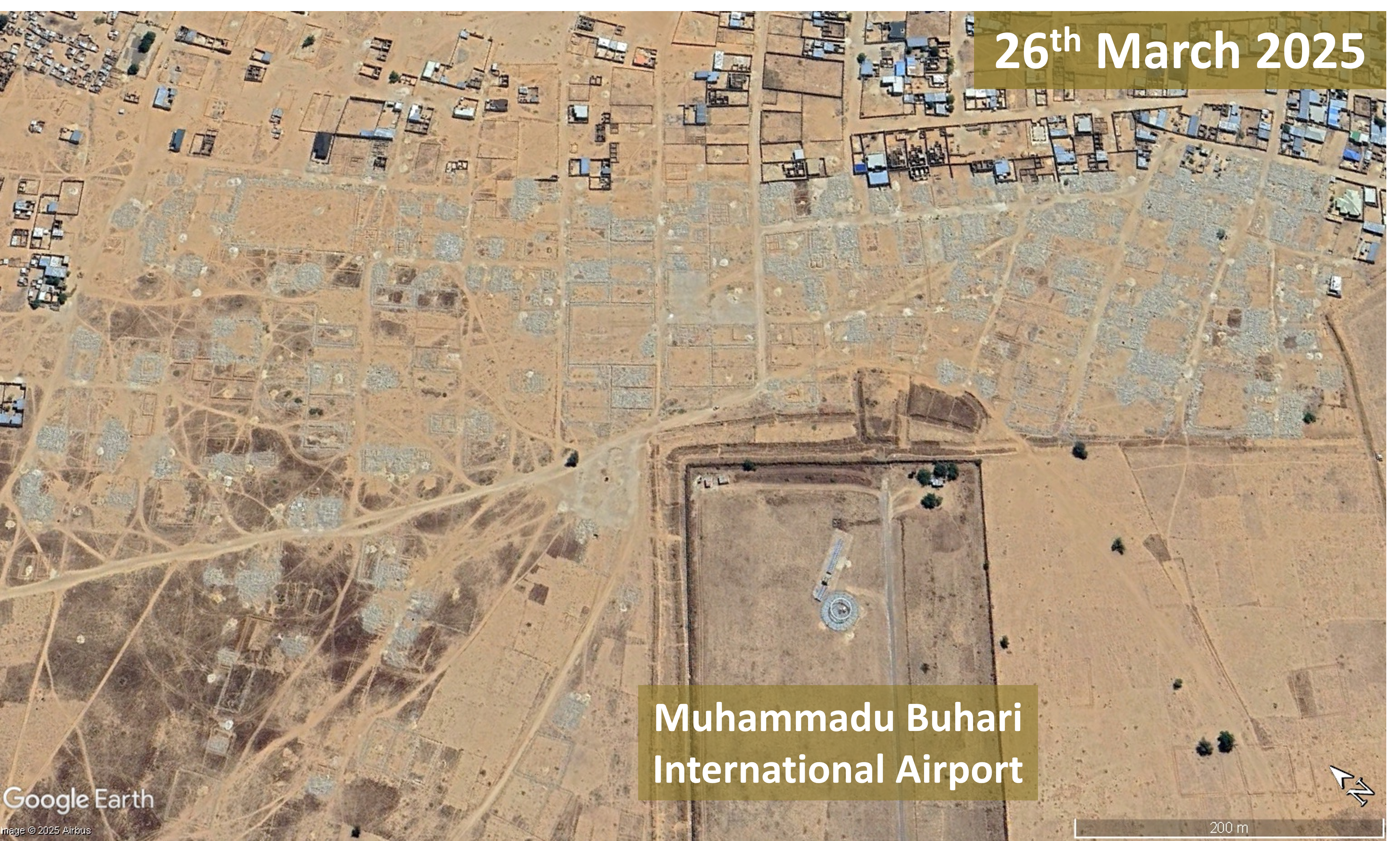
Vlora Airport, opposed by many environmental organisations, has received a high level of government support and will serve luxury tourism developments.
Vlora Airport, a major construction project nearing completion in the Vjosa-Narta Protected Landscape on the South Albanian coast, has been opposed by many environmental organizations, including Protection and Preservation of Natural Environment in Albania (PPNEA) and EuroNatur, since it received parliamentary approval in February 2018. The project site is near Narta Lagoon, a habitat for many iconic bird species such as flamingos and the endangered Dalmatian pelican. The wider Vjosa Delta area, a complex of wetlands, marshlands, woodlands, reedbeds and sandy beaches, is vital for bird migration routes. A March 2021 letter from a coalition of NGOs to members of the European Commission and Parliament, calling for support in urging the Albanian government to respect national laws and international conventions it has ratified, and to reconsider plans for the airport, was signed by 41 organizations. In the same month it was announced that Mabco Constructions had been awarded the tender for constructing Vlora Airport.
On 7th May 2025, the day before the first test flight landed on the Vlora Airport runway, environmental activists, including representatives of PPNEA and citizens, protested in front of the Supreme Court. For over a year the court had not made a decision on returning a case against construction of Vlora Airport to the Court of Appeal; the lawsuit had been filed on 23rd November 2022. Protesters said the Supreme Court had deliberately delayed the legal process in order to facilitate completion of Vlora Airport. The first plane to land at Vlora Airport, on 8th May 2025, was the private plane of Behgjet Pacolli, owner of Mabco Constructions, the majority shareholder of the consortium constructing the airport. EuroNatur dismissed the test flight, showcasing Vlora Airport just three days before parliamentary elections, as a “big PR show”. The airport was not yet fully operational, neither the runway nor the terminal had been completed. Alexander Trajce, PPNEA Executive Director, said, “While the government is flying-high with the propaganda for the airport, what’s actually happening on the ground involves a rushed and chaotic development built inside a protected area, a myriad of safety concerns both during construction and for future operations.”
Construction fatality and investigation into possible corruption
Just 19 days before the test flight an accident a construction accident resulted in a fatal injury. A 38-year-old worker at the Vlora Airport site died on 19th April 2025 after falling from a height. Two construction company employees were arrested on suspicion of violation of workplace safety regulations. Construction of Vlora Airport has also triggered investigation into possible corruption. The Special Prosecution Office against corruption and Organised Crime (SPAK) announced the investigation in early July 2025, stating, “The Special Prosecution Office against Corruption and Organized Crime has registered criminal proceedings regarding the Vlora Airport concession contract. This proceeding is in the preliminary investigation phase.” SPAK is investigating the details of the agreement between Mabco Constructions owner Behgjet Pacolli and the Albanian government and the contract for Vlora Airport construction.
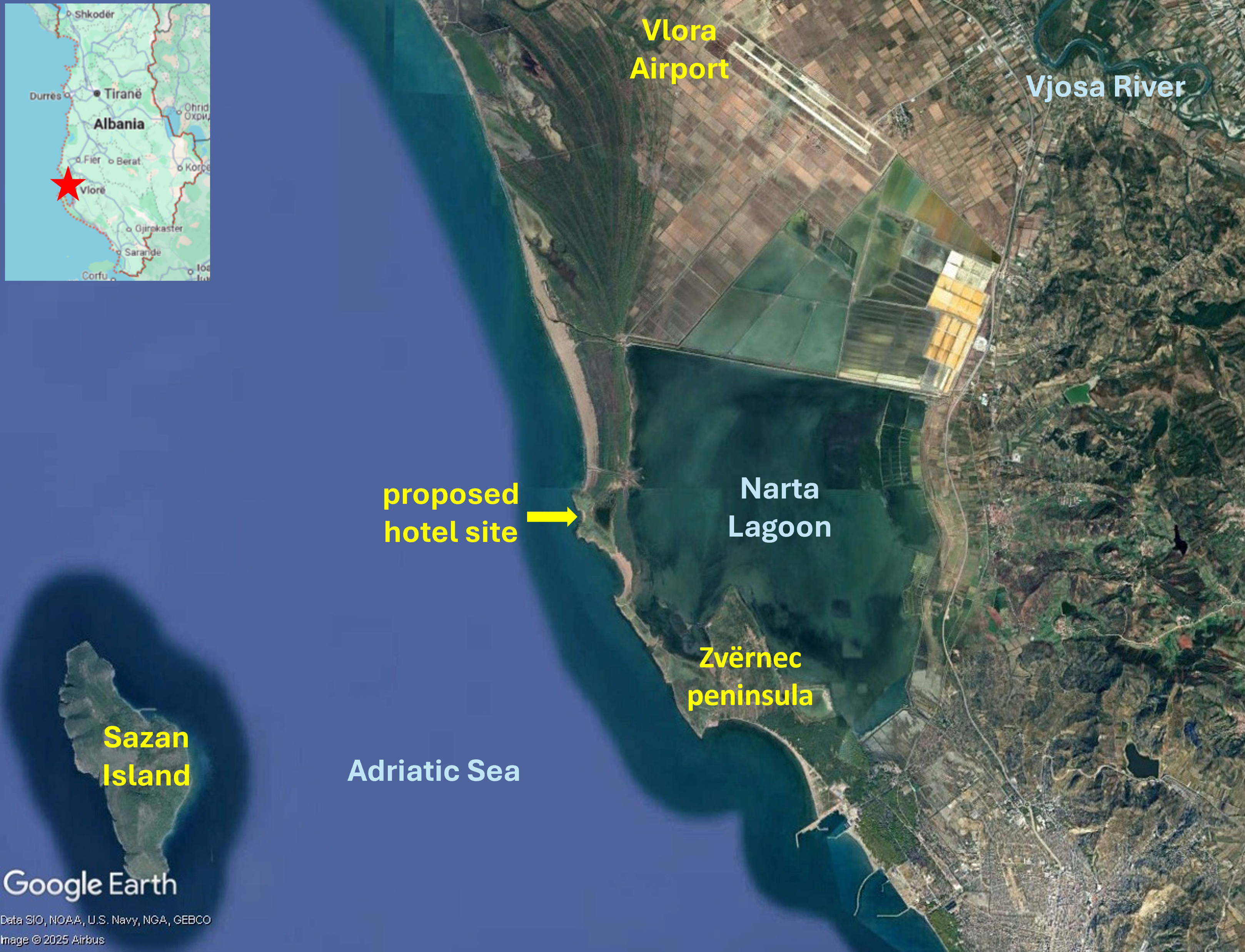
An unprotected delta and Law 21/2024
Conservationists had been hopeful that the government’s creation of Vjose Wild River National Park in 2023 would protect the Vjosa Delta from further destructive development. But the designation only covers the river and streams, not the delta which remains a target for commercial development, with only limited protection subject to Prime Ministerial veto. As airport construction continued, near Narta Lagoon at the heart of the delta, Zydjon Vorpsi of PPNEA warned that while the lagoon may still exist as a water body there will be serious hydrological impacts and aircraft noise and bright lights will disorientate and frighten away birds and turtles. Vorpsi also said Vlora Airport would lead to other development that will “transform the area, resulting in complete urbanisation of the delta”. Development in areas surrounding Vlora Airport has been facilitated by Law 21/2024, a change to the law on protected areas that was rushed through the Albanian parliament in February 2024. Many environmentalists were critical of the new legislation as it enables existing laws to be swept aside to permit construction of upmarket, luxury, five-star, tourism resorts in unprotected areas of the delta. PPNEA, EuroNatur and other environmental and conservation groups said the new law conflicts with international conventions signed by the Albanian government, including the Bern Convention on the Conservation of Wildlife and Natural Habitats. In 2023 the convention’s Standing Committee urged the Albanian government to halt construction of Vlora Airport pending a thorough environmental impact assessment. Law 21/2024 was ratified by President Bajran Begaj only three days after plans for two luxury tourism developments in the delta area were announced by US President Donald Trump’s son-in-law, Jared Kushner.
Luxury tourism proposals – Zvërnec peninsula and Sazan Island
The sites of both proposed tourism projects – the Zvërnec peninsula and Sazan Island – are within protected areas. The Zvërnec peninsula is part of the Pishë Poro-Nartë protected area and Sazan Island is in Karaburun-Sazan national marine park. The Zvërnec peninsula, to the south of Vlora Airport, is a promontory with pine forest and attractive beaches, connected by a wooden bridge to the remains of St. Mary’s, a 13th century Byzantine monastery on a small island in Narta Lagoon. Zvërnec would look very different if the tourism development goes ahead; a 445-hectare luxury resort is envisaged hosting about 6,000 hotel rooms and villas. Architectural renderings of the project published by Kushner’s Miami-based investment company, Affinity Partners, show rows of modern, multi-storey buildings alongside Narta Lagoon and on the dunes, headlands and beaches, a commercial centre, swimming pools, marinas, yachts and a cruise ship.
Plans for a 567-hectare development on Sazan Island are equally high-end. Nearly 10 kilometres west of Narta Lagoon, Sazan is currently uninhabited and one of only a few undeveloped islands in the Mediterranea. Interest in the remains of a heavily fortified military base have made Sazan Island into a tourist attraction; in summertime several ships and dozens of boats provide day trips. The island has a subtropical climate and highly biodiverse vegetation including ash, hornbeam, maritime pine and holm oak trees along with rare ferns. Marzio Mian asked Asher Abehsera, a real estate executive overseeing the Affinity Partners projects, whether the Sazan Island would still be accessible to local people. He replied, “I think everyone should have the opportunity to visit the island”. Kushner’s response seemed more indicative of plans for an exclusive enclave, “We’re creating a very high-end luxury product … One of the most compelling points about the island is just the ability to have privacy … But I also think there are certain aspects of the island we can build out that will give people the opportunity to come visit and enjoy some of the food and the trails.”
Strategic investor status for Sazan Island project
The Albanian government approved Kushner’s request to develop Sazan Island in January 2025 when it granted the project strategic investor status. The government announcement reads: “The projected investment of Sazan Island Touristic Resort of 1.4 billion euros fulfils the criteria foreseen in the legislation on strategic investments.” The project also met the criteria relating to employment, anticipated to be 1,000 people during the construction and operational phases. Strategic investor status will grant Affinity Partners zero taxes in the construction phase and the government will provide all the requisite infrastructure including electricity, water and sewage. Director of EcoAlbania, Olsi Nika, a marine biologist voiced concerns about beaches and waters protected by the Karaburun-Sazan maritime national park designation, saying, “What will large public works, the building of docks, yacht traffic and sewage run-off do to the place?”
Albania’s luxury tourism strategy
Vlora Airport and Affinity Partners’ proposed tourism developments are important components of Prime Minister Edi Rama’s campaign to transform Albania into a “champion of tourism”. PPNEA’s Zydjon Vorpsi said this would come at a huge ecological cost including to birdlife and cast doubt on the purported economic benefits. An influx of visitors to seasonal resorts in summer would place a strain on local infrastructure, leaving empty “ghost towns” in the winter. He also said it was likely that most of the tourism revenue would accrue to the firms owning the developments, not to the local community. Kushner has welcomed the government’s support for Affinity Partners’ luxury tourism projects and development of Vlora Airport. Writing in The Guardian, Marzio Mian recalled a conversation in which Kushner described Rama as a “great partner” and said of the government, “They’re building an airport right there”. Noting that in 2024 almost 12 million foreign visitors, a 15 per cent increase compared to the previous year, had travelled to Albania, Mirela Kumbaro, minister for tourism and the environment, said the number was too high, “too many for us, and too much pollution”. Kumbaro said, “Sazan is the way to go. The ideal recipe: nature and luxury tourism.” The Albanian government is extending a great deal of support to elite tourism which will benefit a small number of wealthy visitors. And the focus on developing exclusive resorts in the undeveloped southern coast appears to be at odds with the scale of Vlora Airport. The 3.2 kilometre runway is the longest in the Balkans and Vlora Airport is expected to become the second-largest in Albania with an initial capacity for 2 million passengers per year, expanding to accommodate ten million within a decade.